All Activity
- Past hour
-

MO/KS/AR/OK 2025-2026 Winter Discussion
NWAflizzard replied to stormdragonwx's topic in Central/Western States
This is just a monster storm. Like two and a half to three day event. Somebody is really going to cash in if this thing comes a little more north. -
It's genuinely probably because the GFS is a terrible model. I'm not even joking.
-
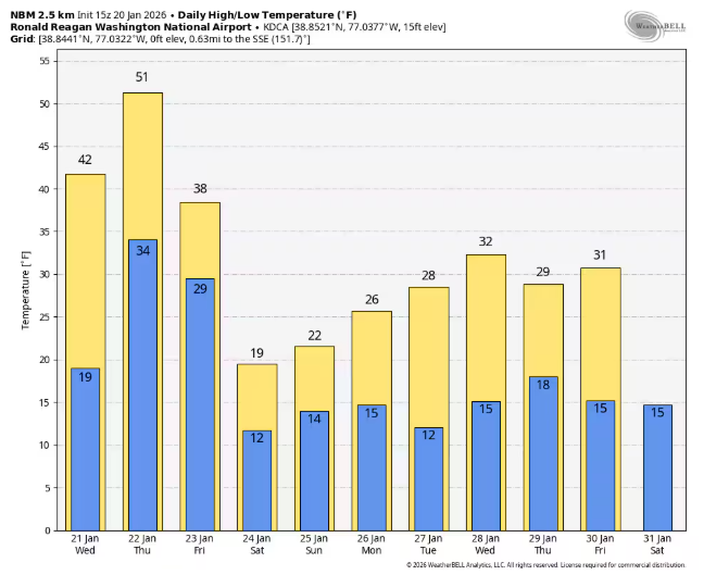
Yep. NBM, courtesy of CWG's article
-
Any further word on the 18Z GEFS? I take it they at least held from 12Z and look solid?
-
Okay, then what would make it jump like it did withoutany new data? I'm trying learn.
-
I don’t smoke but I need a cigarette
-
Southern edge is super sharp. Sleet and snow line will be key. Very difficult to forecast .
-
There was that one GFS off run (hmmm - kind of similar!) with it south... only to turn around and bring the big stuff... MAN! Remember the radio show before that one! DT was on it when he was kind of tolerable... LOL!
-
0z going to have a cutter to Detroit. But glad it and the AI shit out all tha bad chili from 12z
-
Disconcerting that it’s such an incredible change
-
I don't think those things are going to get sampled until tomorrow.
-
 The 1/20 18z GFS showed better phasing as both the northern and southern branches of the jet stream were better aligned. The result is that snowfall got into the New York City area unlike with the 12z GFS. The 12z ECMWF, GGEM, and UKMET continued to show a snowier outcome for New York City. Historical data for 6" or above Washington DC January-February snowstorms also argues strongly against a shutout in the New York City area. Within the next day or two, model skill will improve and confidence in the solutions will increase. Key factors to be resolved: 1) Jet stream interaction/Degree of phasing 2) Strength and position of Arctic high and confluence There remains a risk of suppression and/or a sharp cutoff of precipitation on the northern edge of the storm. However, New York City and its suburbs still remain very much in the game for a moderate or significant snowfall, especially when the more skillful guidance is considered. The 1/21 0z runs will provide additional insight.
 -
 early afternoon Sunday should be snowing 2pm or so!
 -
Still a ways to go but things aren't backing off yet. However, I would 10000% be prepared. That run was ... mind blowing.
-
Question, would the difference be due to sampling some of pieces that are needed to make this the storm
-
Also pretty cool that it doesn't seem to get above freezing for at least the week after the storm.
-
Nothing safe with this one.
-
Not liking the north trend with the snow line here. Going the wrong direction. That warm nose means business.
-

January 2026 regional war/obs/disco thread
DavisStraight replied to Baroclinic Zone's topic in New England
Lewiston sled shop in the news, you know it dryslot? Says they need another 6 inches for ideal sledding. -
GFS really is out to lunch lmfao. I should learn this by now. How does a model go from literally nothing to warning level snowfall in 1 run
-
The southern edge is sharp as a knife. Be careful within 100 miles of that. Have your weather kit prepared. Ice ice baby .
-
Probably the best GFS run I have ever seen for WNC. That was impressive and it starts precipitation late Friday night. 48 hour event.
-
Hi 24, low 16 Tuesday.
-
Also, as you head north the ratios increase incrementally so the northern tier of the snow maps will be higher and more uniform due to the higher ratios.
-
The real question becomes...where does that sleet line set up?


