All Activity
- Past hour
-
There were still some real nasty localized winds, but thankfully this one doesn't seem to be as widespread as the Wednesday one.
-

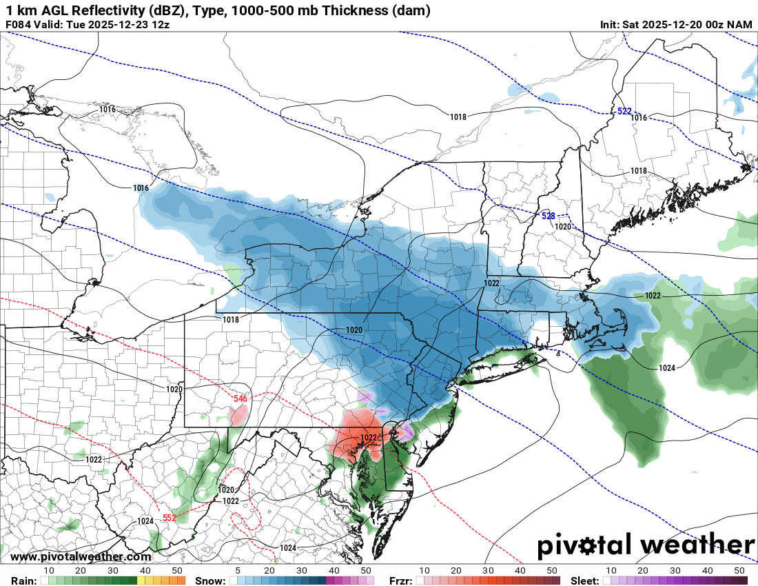
Possible Light Snowfall (1" - 3") on Tuesday Dec 23
MJO812 replied to Northof78's topic in New York City Metro
Nam and Icon
.thumb.png.2de8b61bf989ae9b5002f9d3f6b07a14.png)
-
Icon
.thumb.png.0681e1087e60beb25901d23204845af8.png)
.thumb.png.eeb3bd0670efaf1e155ed36288614cbe.png)
-
Happy Anniversary!
-
Actually under a good burst right now…
-
26° less than half an inch of snow which turned into sheer ice on the roads, highway department is out but it’s treacherous
-
Snow squall warnings up along the Canadian border. Some good reflectivity sagging into NNE.
-

December 2025 regional war/obs/disco thread
WinterWolf replied to Torch Tiger's topic in New England
You know what I mean…everything in the future is an IFFFFF. -
If ifs and buts were candy and nuts, we'd all have a merry Christmas
-

December 2025 Short/Medium Range Forecast Thread
Golf757075 replied to John1122's topic in Tennessee Valley
That image i posted earlier would be a TOTAL game changer if it happens. Still preliminary of course. -
December 2025 regional war/obs/disco thread
WinterWolf replied to Torch Tiger's topic in New England
Let’s juice this beotch up as we close in dammit. -
Juicy

-
I know it’s extending the Nam out, but looked like it would be good for a lot of SNE. Fairly cold.
-
Northern queens, nyc
-
So.......you folks that live near a ski area.......how bad was the damage?
-
December 2025 regional war/obs/disco thread
WinterWolf replied to Torch Tiger's topic in New England
+TNH…don’t think I’ve heard of that tele before? -
And out goes my power, off, on, off on off. Thank God for a standby generator
-

December 2025 regional war/obs/disco thread
40/70 Benchmark replied to Torch Tiger's topic in New England
His thoughts..not mine, but I guess I could see it as a phase change to my +TNH -

December 2025 Short/Medium Range Forecast Thread
Holston_River_Rambler replied to John1122's topic in Tennessee Valley
Here be ye olden control: MrGolfman, here ye go, the weeklies mean: -

December 2025 regional war/obs/disco thread
Kitz Craver replied to Torch Tiger's topic in New England
Wherever they rest their little moose heads -

Central PA Winter 25/26 Discussion and Obs
Voyager replied to MAG5035's topic in Upstate New York/Pennsylvania
Got the roads clean of salt and all the snow out of my yard, and guess what? It's f-ing snowing here and everything is starting to get white... - Today
-

December 2025 Short/Medium Range Forecast Thread
Carvers Gap replied to John1122's topic in Tennessee Valley
That control @Holston_River_Rambler. Delta from high to low...9! The good thing is the mean is negative. I actually favor the control run - wild swings likely. AO looks pretty much the same. This has gotta be that SSW moving things around. This also fits QBO climatology which favors HL blocking. Probably all of that is connected in some way. -
.thumb.jpg.6a4895b2a43f87359e4e7d04a6fa0d14.jpg)
Central PA Winter 25/26 Discussion and Obs
Yardstickgozinya replied to MAG5035's topic in Upstate New York/Pennsylvania
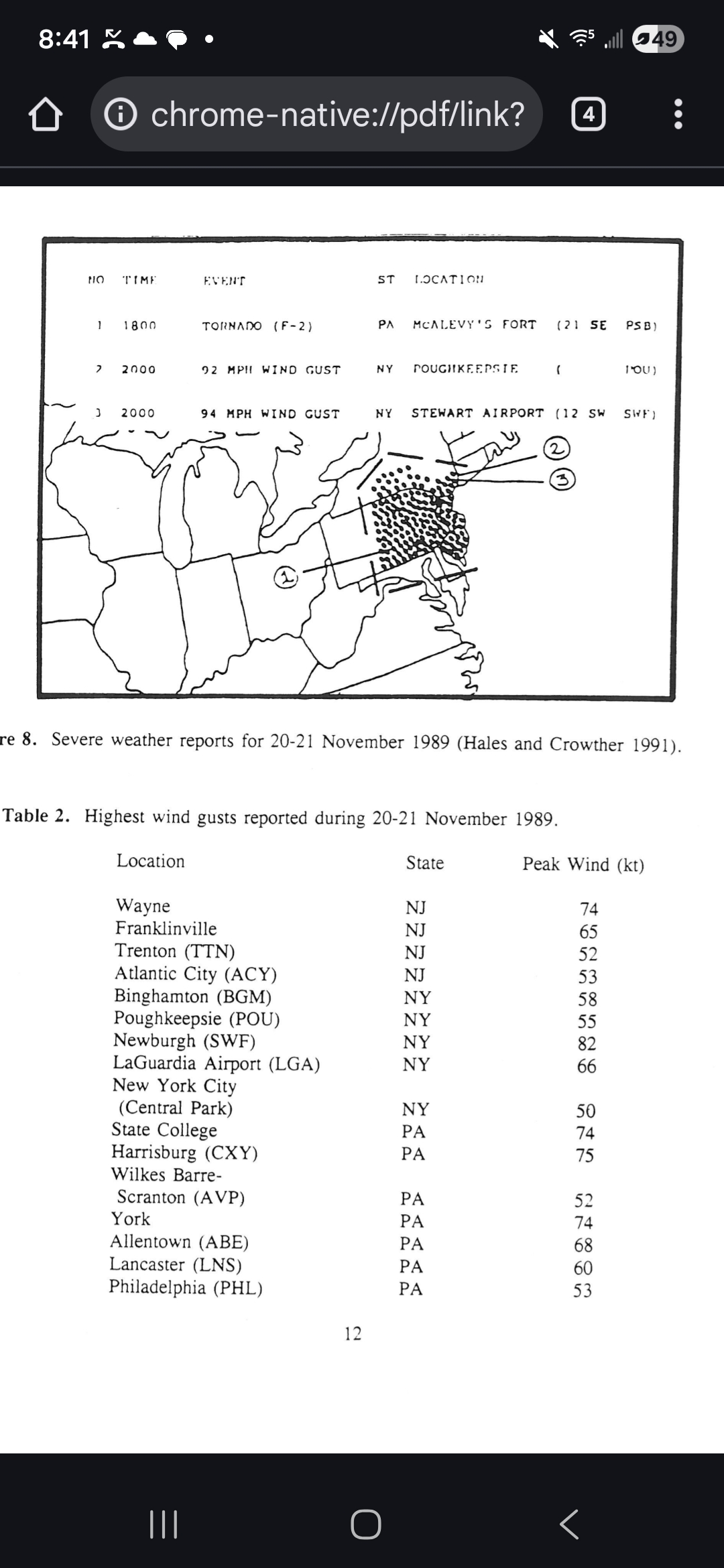
There's definitely no hype to some of these wind events this fall and early meteorological winter. As I said before I find in my general area that these events usually can't get there advertised winds to the ground and that hasn't been the case over the last few months. I've also had several extra truckloads of tree debris from all my clients this year from Union Deposit to Dillsburg. This morning is possibly one of the most gnarly wind event I can remember at my home since the historic low dew point derecho of 1989. Below is some information on the 1989 low dewpoint Derecho. One of the most interesting and rare weather event most of us got to experience in our lifetimes. https://www.google.com/url?sa=t&source=web&rct=j&opi=89978449&url=https://repository.library.noaa.gov/view/noaa/6824/noaa_6824_DS1.pdf&ved=2ahUKEwiai_iXisuRAxVzFlkFHbeBElcQFnoECFoQAQ&usg=AOvVaw2L8H8kDzIM5k9RkZFJmF4U
-
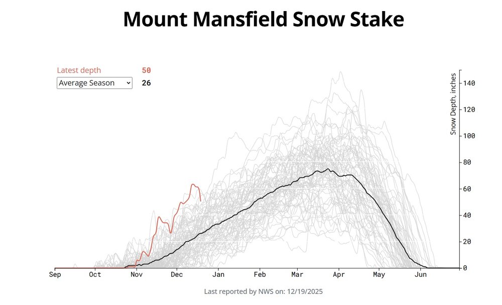
Yeah, Mansfield depth dropped a healthy 10" but really just the air came out of the fluff. Couple inches of new snow up there after the changeover. Snowpack looked fine leaving at 5pm with a coating at 1,500ft. Dropped down to 4th deepest depth for the date since 1954, ha. Nice to have a thaw result in "falling" to a still top-5 snow depth.
-
Ha! A lot you know. Moose don’t have dens!