All Activity
- Past hour
-
SE MA cleaned up unbelievably in that 15 year stretch....they were easily the most AN for snowfall anywhere in New England during that timeframe. They are a decent spot for big storms already, but those years just went crazy bonkers with the frequency of biggies.
-
I just counted the # of days in Jans 1975-89 by MJO phase: there are stark differences vs Jans 2011-25 as was suspected:# of days per phase Jans 1975-89 (465 total days)/% of Jan days per phase1: 39 (8%)2: 67 (14%)3: 67 (14%)4: 57 (12%)5: 46 (10%)6: 51 (11%)7: 63 (14%)8: 75 (16%)Compare to this that I posted yesterday:# of days per phase Jans 2011-25 (465 total days)/% of Jan days per phase1: 17 (only 4%)2: 26 (only 6%)3: 67 (14%)4: 51 (11%)5: 57 (12%)6: 101 (a whopping 22%)7: 104 (a whopping 22%)8: 42 (9%)So, what changed the most in Jan when comparing 1975-89 to 2011-25?# of 8-1-2 Jan days dropped sharply# of 6-7 Jan days rose sharplyJan 1975-898-1-2: 39%6-7: 25%Jan 2011-258-1-2: 18%6-7: 44%So for Jans when comparing 2011-25 to 1975-89, the # of 8-1-2 days dropped way down from 181 to only 85 (drop of 96 days) while the # of 6-7 days rose sharply from 114 to 205 (rise of 91 days)! Phase 8 went from having the largest # of days of any phase Jan 1975-89 to having only 40% of the largest # of days of any phase Jan 2011-25! @donsutherland1@bluewave@40/70 Benchmark@snowman19
-

January 2026 Medium/Long Range Discussion
SomeguyfromTakomaPark replied to snowfan's topic in Mid Atlantic
12z GFS not interested in dropping that energy through the Rocky's and phasing like the ICON does. -

January 2026 regional war/obs/disco thread
dendrite replied to Baroclinic Zone's topic in New England
Like I said last night though…the midnight high can net you 2 days of 50° if the fropa timing is right. Let’s butcher those negative anomalies with some bush league tactics. -
Unfortunate waste of potential in both the and departments. Could have done something significant with a little more antecedent cold air to pull in on the back side and different timing/better lapse rates in the warm sector.
-

January 2026 regional war/obs/disco thread
ORH_wxman replied to Baroclinic Zone's topic in New England
Need to get past 1/15 for cold to return....we can sneak in marginal snow before that, but my best guess is the 1/15-1/20 period is one that needs to work out in order to turn the month into a potential AN snowfall month. Don't want to count on the final 10 days to drop double digits. -
Ready2rumble Spring vibes today
-
So far w/ the 12z suite is rolling: 1. The ICON hass a coastal system and could trend much bigger if real... 2. The GFS and RGEM both have pretty decent snow shower activity Sunday.
-
FWIW, the 0z CMC/GDPS did phase some of the southern stream like the 12z ICON. Not perfectly clean, but enough.
-

Central PA Winter 25/26 Discussion and Obs
pasnownut replied to MAG5035's topic in Upstate New York/Pennsylvania
After the walk down memory lane..... Well looky at Z Icon. Staring the nooners off w/ a bang. -
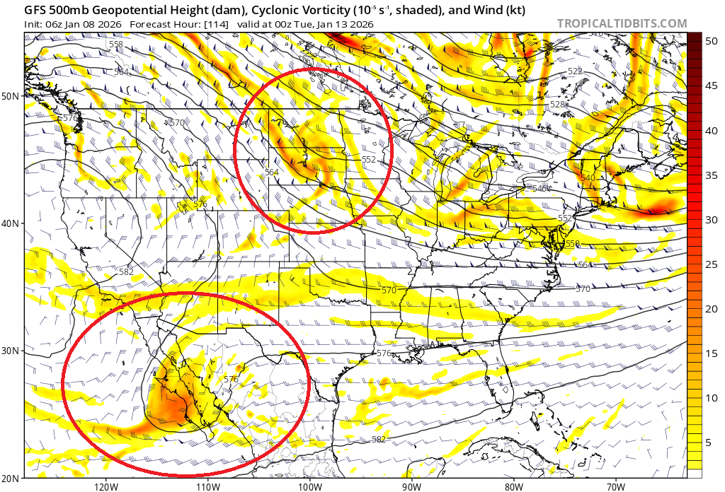
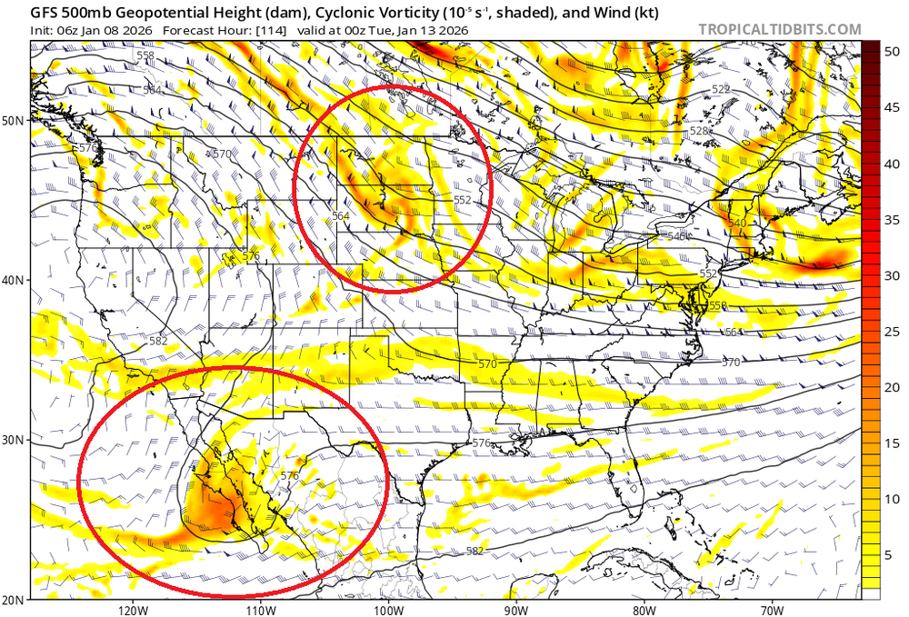
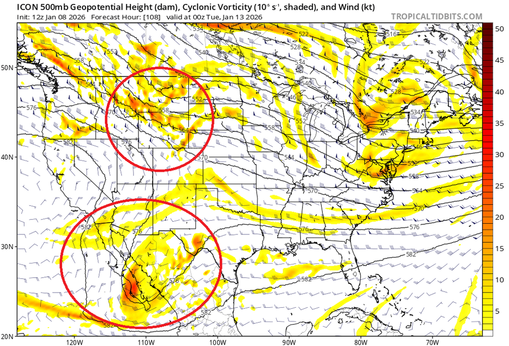
The ICON would be a nice snowstorm for most of our area if it played out that way. But the 12z ICON is significantly different than the 6z GFS and 0z ECM plus almost all individual ensemble members. By 0z Tue, the initial shortwave energy to eventually carve out the longwave trof in the MS valley is in WYOMING on the ICON. But it is noticeably further east through the DAKOTAS on the GFS and ECM. Related to this feature is the phasing of the upper level low in the Southwest US. The further west positioning of the northern stream shortwave on the ICON allows most of the southern stream energy to phase into the developing longwave trof, which sets the stage for a much better trof orientation and 500mb height field. I think the ICON is wrong with this feature, but I'll be watching subsequent runs closely.
-
Not too many posters have probably been paying attention to this storm but there has been a huge NW/stronger trend with this over the last few days. It doesn't mean much to most here but to see systems becoming stronger as they get closer in time instead of weaker like we've seen the last 10 years is different.
-
Source region is rebuilt in western Canada by MLK weekend, offering a new cold air supply that should leak into the northeast. I am seeing more signals for active southern stream as well. Think end Jan to early Feb looks pretty decent setup wise at this early juncture as well.
-

January 2026 regional war/obs/disco thread
Snowcrazed71 replied to Baroclinic Zone's topic in New England
I'm sorry you're feeling pretty defeated. But I have to disagree with you. Keeping it real is one thing, but you've teetered over to the point of self-loathing. I'm not trying to read you at all, but once you get to this point, everything is a negative. Is the pattern amazing, no, but is there there some real good guidance to the pattern becoming much better, yes. So your garbage pattern theory might be good for the next week but after that not so much. My biggest hope is we do get a really good storm that will brighten everyone up including you and give everybody what they're looking for. -

January 2026 regional war/obs/disco thread
Cyclone-68 replied to Baroclinic Zone's topic in New England
Not much on the ground here and it looks like it’ll completely disappear by tomorrow. -
Looking at the numbers, map looks pretty accurate. For the period since December 15, Omaha had it warmest mean high temps (by more than 2F!). With Des Moines in 4th place by the same metric: Moline officially in 13th place by this metric, but 4 of those years predate the start date of IEM's analysis. So 9th warmest since 1893.
-
Yup I remember that.. the Dgex nailed it!!!!
-

Central PA Winter 25/26 Discussion and Obs
Itstrainingtime replied to MAG5035's topic in Upstate New York/Pennsylvania
Well that sucked. I always assumed that Lancaster City and Columbia Borough were the last 2 districts to close, but I didn't pay attention that super close. -
why was the thread deleted? We might've jinxed it here lol
-
Seems like a 50/50 low locks everything in? Not a terrible spot for the antecedent high, not great either. IIRC, that setup worked for 12/19/09 too.
-

January 2026 Medium/Long Range Discussion
NorthArlington101 replied to snowfan's topic in Mid Atlantic

-
DGEX and then the DGEX and Canadian for the 2/10 event.
-
I’m not disputing Eric, but it seems somewhat counterintuitive that the cold E US is still favored in Feb even with a +AO/+NAO. Wx history is so fascinating!
-

2025-2026 ENSO
so_whats_happening replied to 40/70 Benchmark's topic in Weather Forecasting and Discussion
Yea it is a fascinating climo around here. Yea I was on shift when we got that .2" lol did not expect the season to be just horrid. Unfortunately Baltimore may have some snow total issues for storms in the future. We are no longer measuring as weather observers it is across the airfield now, measured by EMS. -
The low pressure over the lakes will not allow this storm to come up north. It acts as a kicker and pushes the weak low pressure out to sea. Regardless of any model surface map depictions, as long as you see that Great Lakes low, you can pretty much write off a storm climbing up the coast. Western ridge is in good spot. This is one of the times where we would want a western Atlantic ridge to try to trap that storm in. Still plenty of time for changes but until that changes, this threat is non existent