All Activity
- Past hour
-
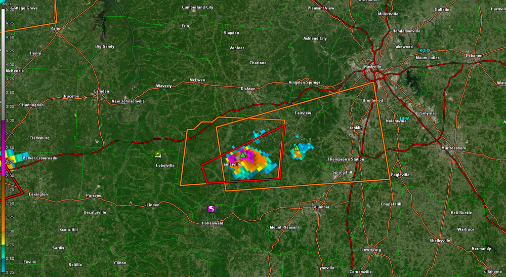
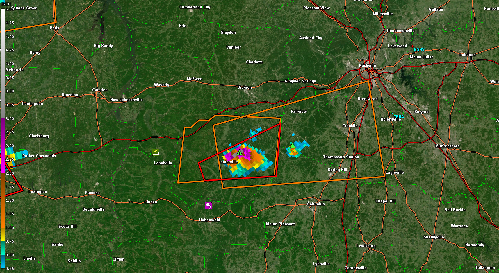
Some big hail ,the Centerville cell
-
38.3 here last night. Probably not done with the 30s quite yet this spring but glad it didn't go much below that. Spent several weekends planting recently and it would suuuuuck having to redo that.
-

2025-2026 ENSO
Stormchaserchuck1 replied to 40/70 Benchmark's topic in Weather Forecasting and Discussion
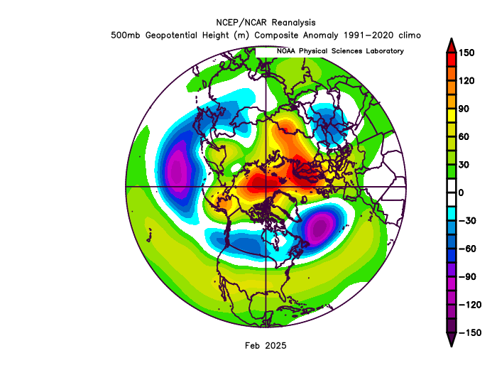
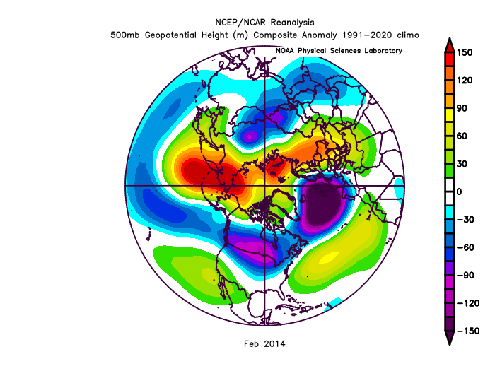
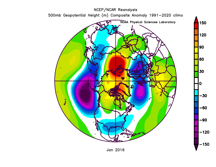
^I would say there was more +PNA, low pressure over the north Pacific in those two analogs. Feb 2014 looks like a pretty good N. Hemisphere 500mb match though. It takes about 6 days for a Pacific-PNA change to work its way to the SE ridge. We had a strong Aleutian High late Jan-early Feb. The south-based +NAO kept the SE ridge amped, without a major North Pacific trough present to cut it down. -
But similar patterns with great -AO blocks over 90N didn’t have any issues producing KU snowstorms in February 2014 and January 2016. So we can’t blame the +NAO either since the vortex near Iceland was much stronger those two months than this February. It comes back to the overpowering Northern Stream of the Pacific Jet which was much weaker in February 2014 and January 2016.
-
It'll be interesting to see how your actual vs. forecast verifies. I bust low/high (sometimes significantly) depending on the setup. Radiational cooling nights I always bust low. Sunny/dry I always bust high. What's the elevation of your cabin?
-
2025-2026 ENSO
Stormchaserchuck1 replied to 40/70 Benchmark's topic in Weather Forecasting and Discussion
Nice link! That -AO was completely over 90N, and the NAO was raging positive to the south of Greenland, putting a ridge over Europe and a SE ridge. I don't see that pattern as all that anomalous. When the AO first went negative, we had to have to some time to change the heavy Aleutian ridge that happened in Late January/early Feb. Remember how the Polar/mid-latitude Cell's work - a ridge centered over 90N puts a trough at 45N. And in the Atlantic at 45-50N was a massive low, since this one was closer it impacts us more. -5 AO's of the past had an arctic high pressure further south. -
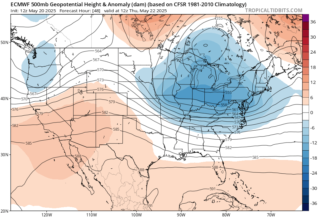
The big cutoff low which has become a familiar late May repeating pattern over the last 10 to 15 years.

-
Confirmed tornado moving through a very populated area near Jackson TN, though luckily it doesn't look particularly strong on radar.
-
Look like the event is trending drier for Wednesday into Thursday east of I-81?
-
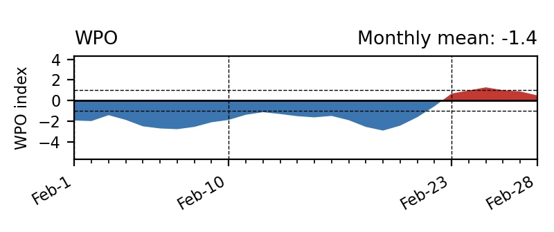
We can’t blame the WPO for last winter since there was a decent -WPO interval during the Feb 1 to Feb 21 with a solid block in the Bering Sea.This also coincided with a -5 daily -AO which reliably produced KU snowstorms in the past. Very difficult to pull off with such a powerful Northern Stream of the Pacific Jet which gave us a potent Great Lakes cutter at the some time the -AO was down near -5. So another Southeast Ridge link up with Greenland to Iceland blocking. https://www.ncei.noaa.gov/access/monitoring/monthly-report/synoptic/202502
-
We've really lost May as a summer month. Been replaced by April.
-
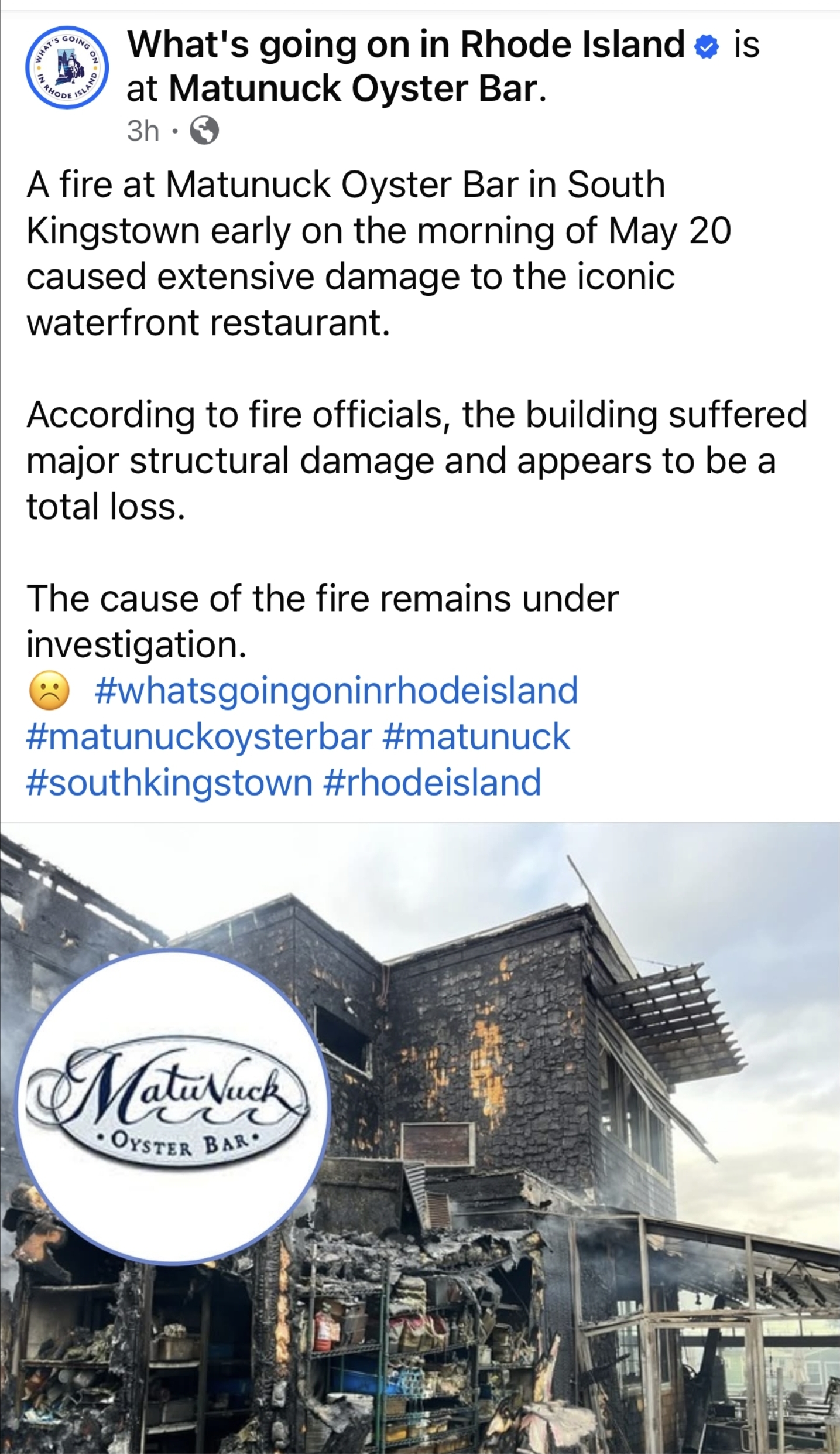
This sucks. https://www.wpri.com/news/local-news/south-county/fire-breaks-out-at-matunuck-oyster-bar/

-
Beautiful day in the Annapolis area to watch the Blue Angels!
-
Confirmed Tor headed towards maybe Duck River
-
Confirmed Tor headed towards maybe Duck River
-
Nothing stops lawn domination not even footwear!
-
If we could’ve gotten any of the colder periods this winter to match with decent moisture it would’ve been a 40-50” snow winter in NYC. Instead we had the roaring Pacific destructively interfere potential setups to death over and over, favor more garbage SWFEs and keep other storms suppressed that could form. I’m not as concerned about the rising average temps (although that’s of course hampering our making any marginal temp setup work) as getting the Pacific to slow down and allow amplified setups in a good location for B/M tracks. We can get absolutely blitzed by a storm or two and end up well above average like in 15-16 despite near record warmth overall. Feb 2016 was also an underrated snowy month around NYC and east.
-

2025 Short Range Severe Weather Discussion
A-L-E-K replied to Chicago Storm's topic in Lakes/Ohio Valley
counterpoint: send 'em up - Today
-
Gray skies, sweater weather and fall feels in late may. No complaints here!
-

2025-2026 ENSO
michsnowfreak replied to 40/70 Benchmark's topic in Weather Forecasting and Discussion
All good points. There is way, WAY too much focusing by some on how much a temp has risen at any given location than there is to the overall pattern. The snow season spans a minimum of half the year for most northern locations, same as it always has. The key is the pattern, the indices, the storm tracks, the available moisture. Its actually gotten comical how some have tried to push the record snow from a decade ago as being in the far distant past or in a different era. -

2025 Short Range Severe Weather Discussion
IWXwx replied to Chicago Storm's topic in Lakes/Ohio Valley
Stay downstate. -
60/45 Summeh.
-
Found out today my coworkers family cabin burned down due the fires up north. They can’t even clean up until the insurance adjuster comes out which isn’t for another week. Ironically he showed me a picture of unscathed plastic chairs surrounded the fire pit. Nearing 2” storm total precipitation in Minneapolis. Perfect long duration event. Wish it would spread further north.
-
I was hot last night. Mowed the lawn this morning in shorts and flip flops, lol
-
2025-2026 ENSO
Stormchaserchuck1 replied to 40/70 Benchmark's topic in Weather Forecasting and Discussion
I think the more realistic scenario is by the time the decadal NAO shifts to negative (could be 20 years), the global temperature would have caught up with the impacts of the index, neutralizing it a little bit. However, this 7-10 year snow drought is so extreme, that we will probably see a bump when more -NAO conditions prevail.

.thumb.JPG.418e8a9a2902ae687ec35ff4bc0e038e.JPG)