All Activity
- Past hour
-
Let me get this straight: So for a major east coast snow storm we need: -AO, +PNA, -NAO, -WPO, -EPO, weak SPV or SW, MJO in phases 1-3, low sun angle during the day, Modoki El Niño SST in Pacific and below normal in Atlantic to keep SER in check, and all cows farting SE in the upper Midwest to push down enough cold air. At the same time at the surface, we need an upper level low in the TN valley, an arctic High over Quebec, and a surface low tracking NNE off of Hatteras....oh and a truckload of luck. What am I missing!!!?
-

January 2026 regional war/obs/disco thread
40/70 Benchmark replied to Baroclinic Zone's topic in New England
Right, but they were all better for snowfall IMBY....thus far. And I see very little hope of that reversing for at least 2 weeks. -
January 2026 regional war/obs/disco thread
40/70 Benchmark replied to Baroclinic Zone's topic in New England
You almost have to hope for a mild pattern and roll the dice with a random bowling ball...I mean, at least in a mild pattern, you have dice to roll. We just can't get any phasing or moisture in these colder regimes. I'm just completely and utterly desperate for a break at this point. -

January 2026 regional war/obs/disco thread
Krs4Lfe replied to Baroclinic Zone's topic in New England
That and 2024 were among the biggest ratters in NYC. We have more snow now than we had those winters. I’ll take almost anything other than 2012,2020,2023,2024. Putrid and barely any cold in those either -
(002).thumb.png.6e3d9d46bca5fe41aab7a74871dd8af8.png)
Central PA Winter 25/26 Discussion and Obs
ChescoWx replied to MAG5035's topic in Upstate New York/Pennsylvania
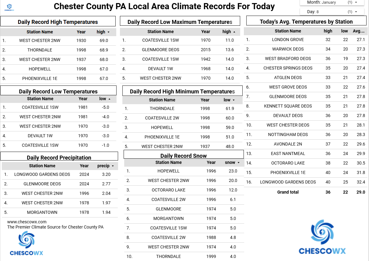
Some large temperature spreads this morning across the area with lower valley locations like Warwick Township with a low at 25.8 degrees while higher spots like here in East Nantmeal could go no lower than 35.7 degrees. Our mild weather continues through Saturday before we turn back to temperatures not too far either side of average for January by Sunday and through much of next week. We have rain chances increasing by later tomorrow and lasting till toward midnight on Saturday night. This could be one of our more significant rain events in the last few months with some models hinting at over an inch of rain. Looking further ahead it appears likely we turn significantly colder by next weekend but at this point no significant winter events are on the horizon. For those on Team No Snow fingers crossed it stays that way!

-

January 2026 regional war/obs/disco thread
moneypitmike replied to Baroclinic Zone's topic in New England
The lawn in Mattapoisett is looking great. A little frost on it this morning......but it's ready to green up. -
E PA/NJ/DE Winter 2025-26 Obs/Discussion
ChescoWx replied to LVblizzard's topic in Philadelphia Region
Some large temperature spreads this morning across the area with lower valley locations like Warwick Township with a low at 25.8 degrees while higher spots like here in East Nantmeal could go no lower than 35.7 degrees. Our mild weather continues through Saturday before we turn back to temperatures not too far either side of average for January by Sunday and through much of next week. We have rain chances increasing by later tomorrow and lasting till toward midnight on Saturday night. This could be one of our more significant rain events in the last few months with some models hinting at over an inch of rain. Looking further ahead it appears likely we turn significantly colder by next weekend but at this point no significant winter events are on the horizon. For those on Team No Snow fingers crossed it stays that way!
-
2025-2026 ENSO
40/70 Benchmark replied to 40/70 Benchmark's topic in Weather Forecasting and Discussion
If it becomes that strong, the EMI will be crucial.....Modoki of that intensity and we are talking 2002-2003/1957-1958 analogs.....east-based would mean to shield your eyes and hope for a random juggernaut. 2009-2010 had much more favorable solar considerations... -
1/31-2/1/21 was great too. 18” in NYC. Last time we had any storm over 12”. Solid 9-12” during 1/29/22 blizzard though
-

Central PA Winter 25/26 Discussion and Obs
mahantango#1 replied to MAG5035's topic in Upstate New York/Pennsylvania
I remember back in the late 70s we had a snowstorm on a Monday,Wednesday and Friday the same week. I don't remember what month it was. It was either January or February. Each storm dumped a foot each time. I remember Penndot was working around the clock that whole week plowing. Would be nice to see that again. -

January 2026 regional war/obs/disco thread
Great Snow 1717 replied to Baroclinic Zone's topic in New England
I love cold weather but with that said the pattern as been a total borefest....multi year snow drought continues to roll on.. -
I think we’ll bust warm here in NYC today. Full sun out, no breeze, feels like spring. Warmest weather yet to come this weekend, could be well into the 50s
-
One big one could get us closer to seasonal average. Would make this torch all the more worthwhile
-
2025-2026 ENSO
40/70 Benchmark replied to 40/70 Benchmark's topic in Weather Forecasting and Discussion
I won't delve into that too deeply until the summer, but given that El Nino looks to become reasonably strong, I expect it to get at least neutralish...I don't anticipate a repeat of 2023-2024, which was at the height of the cold phase. Transition to warm phase should come around the turn of the decade. -

Central PA Winter 25/26 Discussion and Obs
pasnownut replied to MAG5035's topic in Upstate New York/Pennsylvania
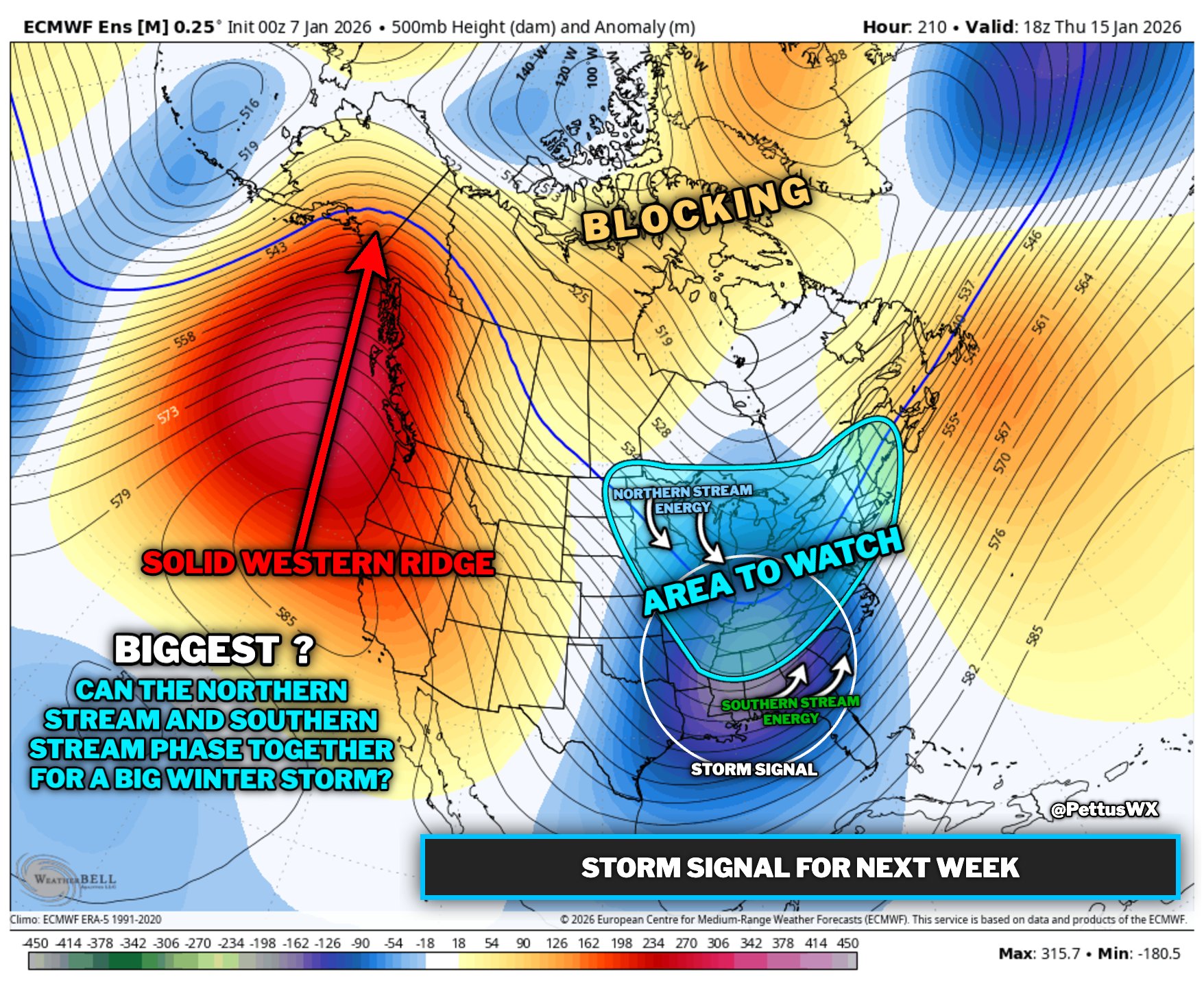
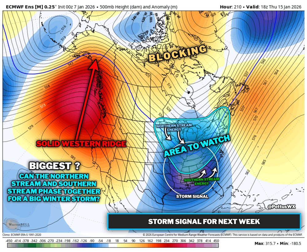
Been thinking the same. Looking at pattern evolution doesnt have that look....but seeing southern stream getting active and lots pinwheeling through the NS, you can see how chances are increasing, and it's litterally a matter of time(ing) till somethin pops. At the minimum it really looks active, so me thinks much modelwatching is about to happen. Prepare for blizz's snowmaps -
-
2025-2026 ENSO
40/70 Benchmark replied to 40/70 Benchmark's topic in Weather Forecasting and Discussion
I'm still around 60", that that is in decline at the moment....it probably peaked around 65" several years back, but I'm staring an 8th consecutive dud in the face. 19.9" (1979-1980) and 127.5" (1995-1996 *sorry*) -
You can get SSTA maps and figures here. Use the Oisst instead of CRW under the "Option" as it's more accurate. https://cyclonicwx.com/sst/
-

January 2026 regional war/obs/disco thread
CoastalWx replied to Baroclinic Zone's topic in New England
Everything looks weird and seems off which is what I was alluding to last night. There’s a chance, but not really excited at the moment. -

January 2026 Medium/Long Range Discussion
BTRWx's Thanks Giving replied to snowfan's topic in Mid Atlantic
Anyone know why the Physical Sciences Division stopped updating ssts? Is this the end for it? https://psl.noaa.gov/map/clim/sst.shtml -
u keep doing u comrade
-

January 2026 regional war/obs/disco thread
Typhoon Tip replied to Baroclinic Zone's topic in New England
Kind of with Scott on the mid monther ... for the time being, anyway. I'm open to changes at 7+ days of course, but ugly overnight. I didn't like 00z GEFs or the EPS regarding that period. They were not representative of a type of system we'd expect to see emerging - better hints in prior cycles have regressed to ...something else. This is all given to the blah blah PNA gobble-dee goop. Both look like some kind of polar boundary with maybe a clipper on it? not very clear what that is... but the passage is NW-SE and not including much of any coherency to a coastal. Basically unremarkable with what they do illustrate. Meanwhile, the operational GFS' 0z and slightly less so, 06z kind of does, but they just look weird. So does the GGEM... -
January 2026 regional war/obs/disco thread
40/70 Benchmark replied to Baroclinic Zone's topic in New England
Snowfall up....heating bill and salt usage down..... -
Last January I remember being elated that it snowed on my birthday. This birthday it will be 73 degrees in the exact same location.
-
I was just looking at my Facebook memories from last January. What a different a year makes lol. Last year it was winter. This year were stuck in November weather like our classic shitty winters lol