All Activity
- Past hour
-

November 2025 general discussions and probable topic derailings ...
Ginx snewx replied to Typhoon Tip's topic in New England
Models are missing the push of the negative EPO. Seen it many times. -
Congrats on taking number 1
-
November 2025 general discussions and probable topic derailings ...
Ginx snewx replied to Typhoon Tip's topic in New England
Omg yes yes yes. -
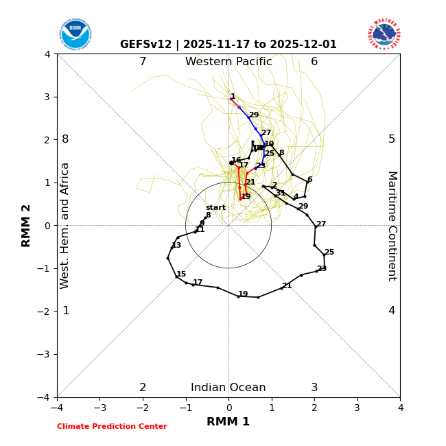
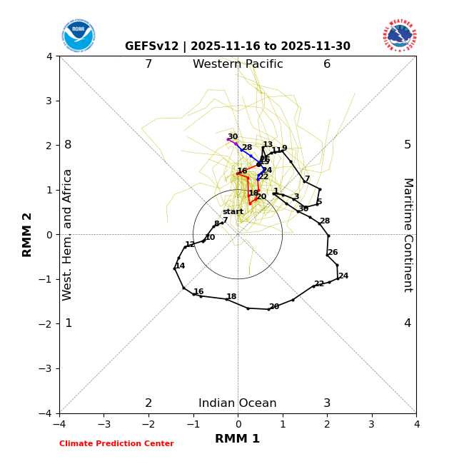
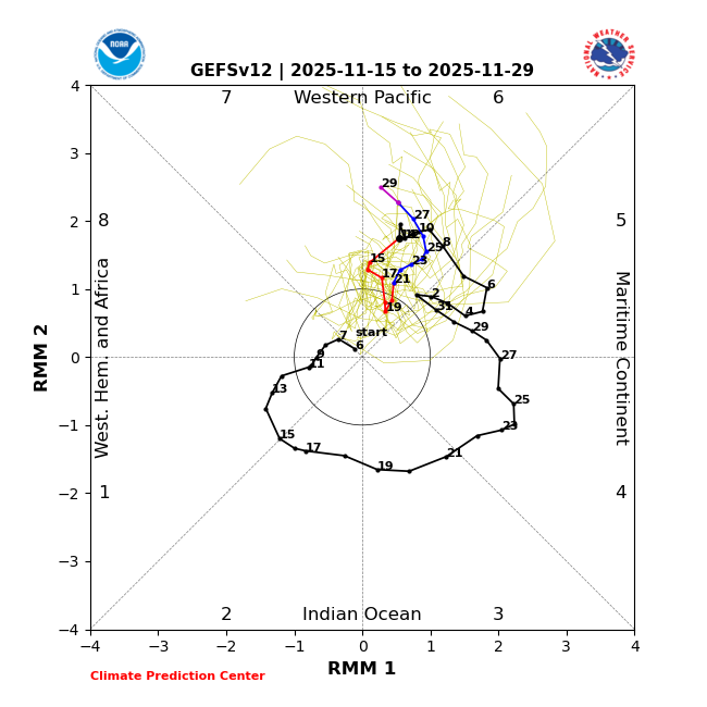
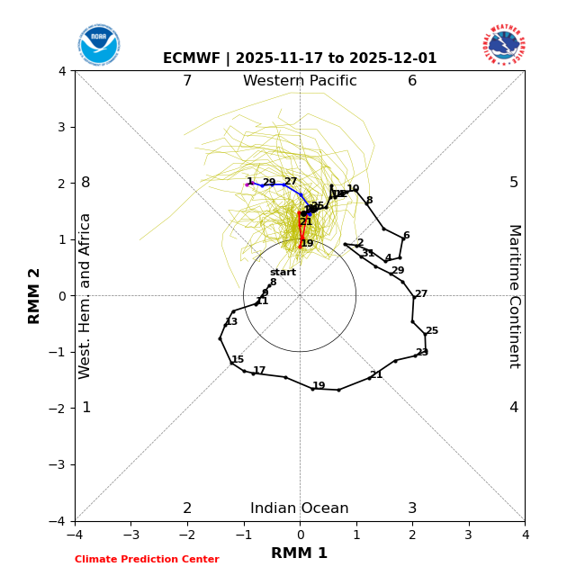
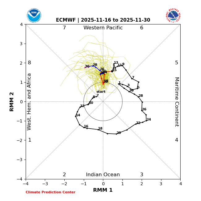
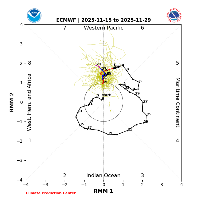
The main issue in recent years with MJO forecasts in general has been the record warm SSTs over the tropical WPAC into EIO stalling convection there. So even if the RMM charts show the MJO going into phase 8, the VP charts will often have convection lingering over the WPAC. Our last clean MJO 8 was back in January 2022. Recent MJO 8 passages on the RMM charts didn’t match the classic MJO VP composites. Since the RMM charts did show a phase 8 but convection lingered near the Maritime Continent. Plus another issue has been the convective forcing stalling in 6-7 before going into the circle or only a very low amplitude MJO 8. So it’s better to monitor the velocity potential charts along with the RMM charts to get a complete picture of the convective forcing.
-

November 2025 general discussions and probable topic derailings ...
WinterWolf replied to Typhoon Tip's topic in New England
It’s been a quintessential autumn in SNE…just what it should be. -

Central PA Fall Discussions and Obs
Jns2183 replied to ChescoWx's topic in Upstate New York/Pennsylvania
I see nothing beneficial in long term. I do see a chance for showers the entire work week Sent from my SM-X210 using Tapatalk -
Yeah, its been spitting flakes off and on over the past hour in this neck of the woods.
-
DT warned yesterday that the MJO push into phase 8 is looking like it’s going to be delayed…
-
IF (If) the GEFS, EPS and GEPS are correct in how far west the ridge is going to set up (Bering Sea/Aleutians) in the long range, then yep, they are underestimating the SE ridge
-
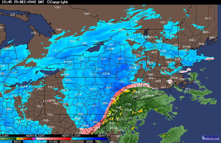
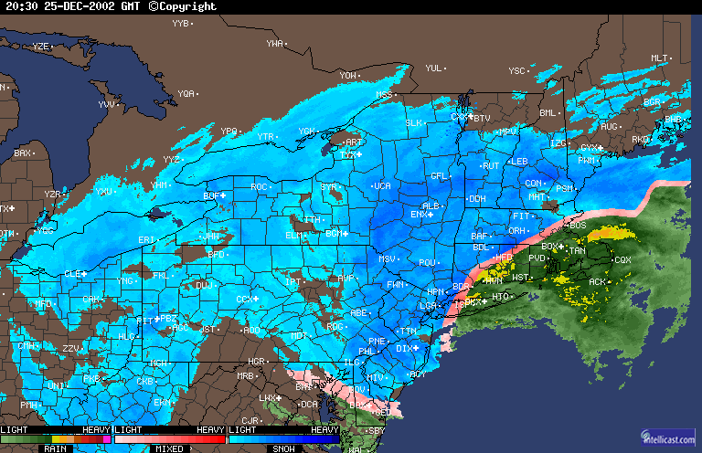
7 to 10 inches here, completely unexpected. Thundersnow by LGA around 4 to 5PM. My car managed to get parked in front of my then girlfriend's house for her parents' Christmas party and there it stayed overnight lol It was a rear wheel drive stick shift with low profile performance tires. Basically the worst combination for driving in heavy, pasty snow.
-

November 2025 general discussions and probable topic derailings ...
GCWarrior replied to Typhoon Tip's topic in New England
Deep winter feel out here in the Berkshires! -

2025-2026 ENSO
brooklynwx99 replied to 40/70 Benchmark's topic in Weather Forecasting and Discussion
I’m pretty sure the GEFS has a strong/cold bias with the SPV, but i could be wrong -
Interesting they were all working for me…
-

Central PA Fall Discussions and Obs
mahantango#1 replied to ChescoWx's topic in Upstate New York/Pennsylvania
Wonder when we're gonna get some benifical rain? My total for the month so far is only .26 -

November 2025 general discussions and probable topic derailings ...
Layman replied to Typhoon Tip's topic in New England
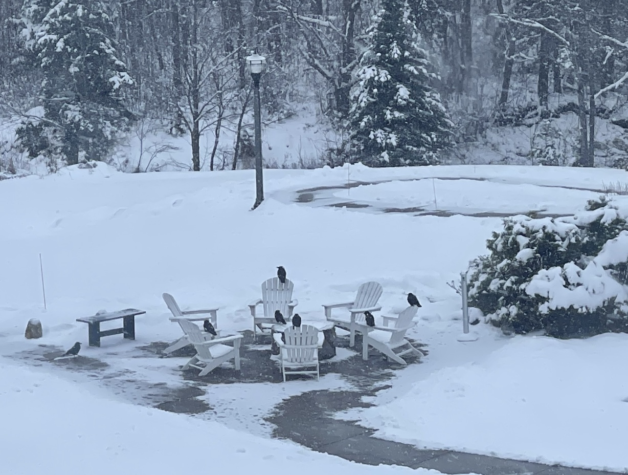
Still snowing nicely up north. The crows seem to have formed a committee to hash out the details of the pending warmup.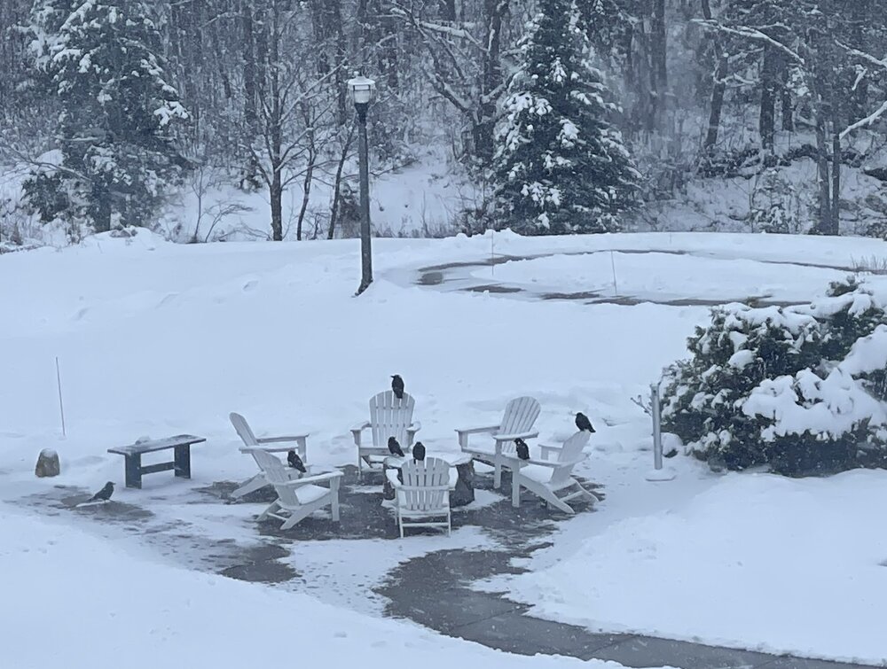
-

Fall 2025 Medium/Long Range Discussion
ChiTownSnow replied to Chicago Storm's topic in Lakes/Ohio Valley
That somehow did not turn out to be a clown -
11/17/25 MJO forecasts is mixed bag: 1) 11/17/25 GEFS backtracked to ~2 days slower than yesterday’s slightly more progressive/weaker run to being nearly identical to the more lethargic and stronger run of 11/15 (not what I wanted to see): GEFS 11/17: stronger/less progressive vs GEFS 11/16 and close to GEFS 11/15 GEFS 11/16: was slightly more progressive/weaker than GEFS 11/15 GEFS 11/15: ————— 2) However, 11/17/25 EPS remains similar to yesterday’s slightly more progressive run and continues to be a good bit more progressive/weaker than GEFS, two things I like: 11/17 EPS: similar to 11/16 EPS and more progressive/weaker than 11/17 GEFS 11/16 EPS: slightly more progressive than 11/15 EPS 11/15 EPS:
-
Good ol Nina
-
One of the rare times backside snow worked out around here. Had about 8-9 inches of cement from that one here...
-
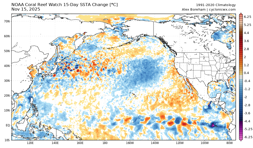
15 day change
-
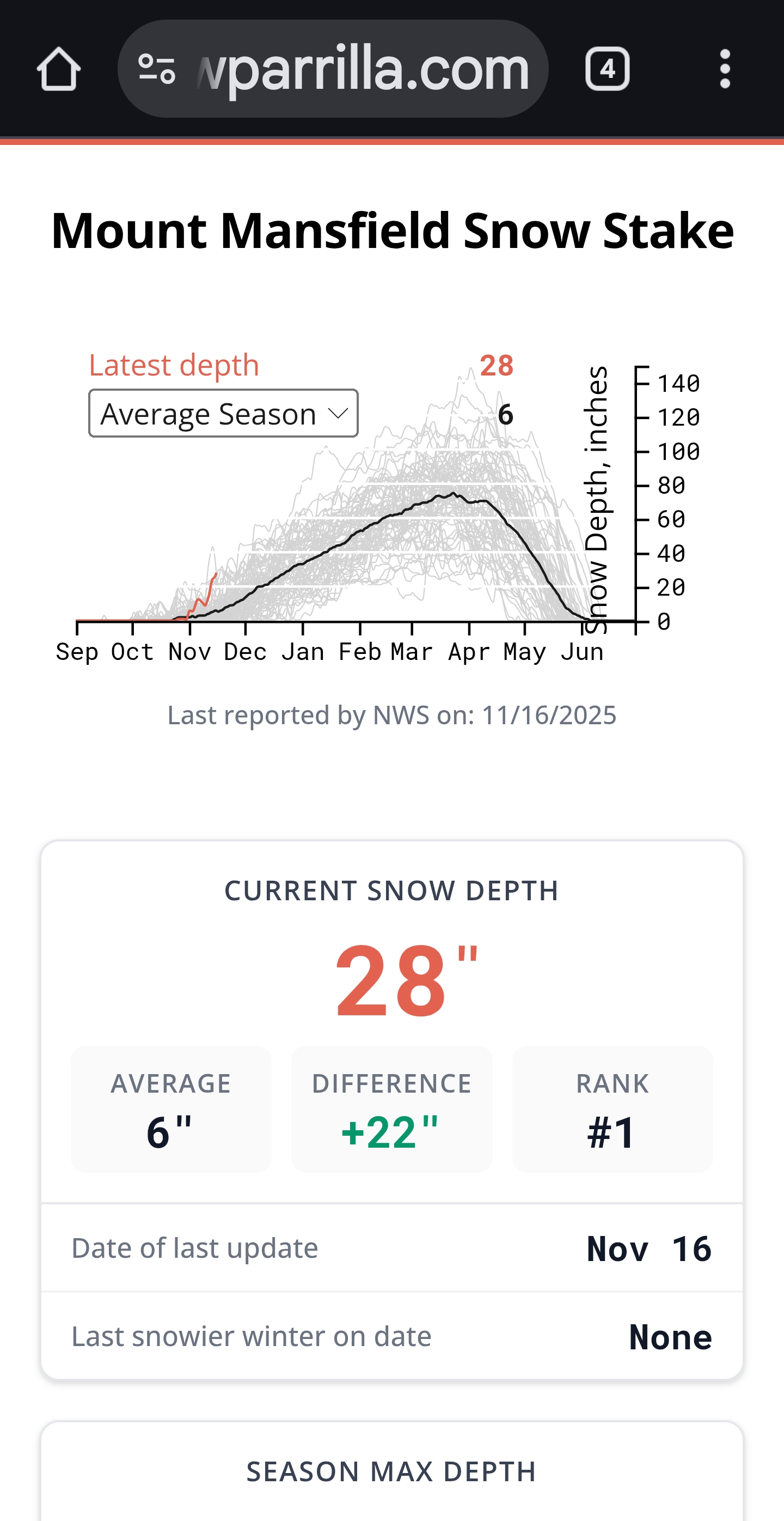
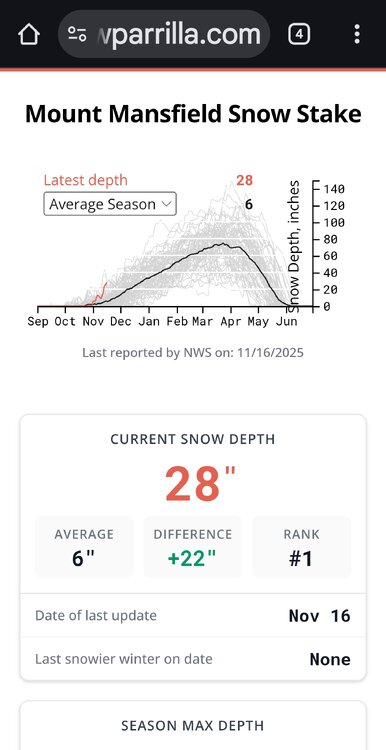
#1 for this date all time and with lots more on the way, not even close… .
-
That was really my only time in Long Beach when a .50 of rain with thunder and low 40s ever transitioned into greater than a 6” snowstorm.
-

November 2025 general discussions and probable topic derailings ...
Spanks45 replied to Typhoon Tip's topic in New England
A true trace, same here....the black pool cover looks like it has salt sprinkled on it. The younger kids were excited -
BWI: 31.2 DCA: 24.3 IAD: 27.8 RIC: 18.1 SBY: 12.5
-
Records: Highs: EWR: 71 (1953) NYC: 71 (1953) LGA: 72 (1953) JFK: 64 (2006) Lows: EWR: 18 (1933) NYC: 19 (1933) LGA: 27 (1959) JFK: 26 (1959) Historical: 1869 - Southwest winds of hurricane force swept the Berkshire and Green Mountains of New England causing extensive forest and structural damage. (David Ludlum) 1894: The temperature at Oklahoma City, OK fell to 9°, establishing their coldest reading for so early in the season. (Ref. Wilson Wx. History) 1927 - A tornado cut a seventeen mile path across Alexandria and southeastern Washington, DC, injuring 31 persons. The tornado struck the Naval Air Station where a wind gust of 93 mph was recorded. A waterspout was seen over the Potomac River ninety minutes later. (David Ludlum) (The Weather Channel) 1927: A tornado (at times to 260 yards wide) cut a seventeen-mile path through Alexandria, Virginia across the District of Columbia from the Navy yard to Benning Rd. & 19th St. NE and Northeast to East Riverdale, Maryland. This storm injured 31 people. The tornado struck the Naval Air Station where a wind gust of 93 mph was recorded. 1933: A cold wave dropped the minimum temperature to 17 °F in Washington, DC. (Ref. Washington Weather Records - KDCA) 1953 - The temperature at Minneapolis, MN, reached 71 degrees, their warmest reading of record for so late in the autumn. (The Weather Channel) 1955: An early season cold snap finally came to an end throughout Montana. Helena, MT experienced 138 consecutive hours of subzero temperatures, including a record low of -16°. Other locations from the Northwest to the southern Plains reporting record lows for the date included: Havre, MT: -26°, Sheridan, WY: -13°, Rapid City, SD: -5°, Billings, MT: -6°, Denver, CO: 5°, Spokane, WA: 9°, TX: 23°-Tied, Dallas (DFW), TX: 26°, Dallas, TX: 29°-Tied. (Ref. Wilson Wx. History) 1958: A deep upper level trough covered most of the west bringing record low temperatures. Bishop, CA recorded a low temperature of 5° which is the coldest November reading ever. This also broke their previous record by 11°. It was 10° in Idyllwild, CA tying their lowest temperature on record for November. Other record low temperatures for the date included: Alamosa, CO: -10°, Casper, WY: -9°, Flagstaff, AZ: -8°, Reno, NV: 1°, Burns, OR: 4°, Tucson, AZ: 24°. (Ref. Wilson Wx. History) 1959: The most severe November cold wave in U.S. history was in progress. Many locations from the Plains to the Appalachians reported record low temperatures: Williston, ND: -10°, Rapid City, SD: -9°, Duluth, MN: -9°, Aberdeen, SD: -8°, Sioux Falls, SD: -7°, St. Cloud, MN: -6°, Sioux City, IA: -4°, Rochester, MN: -4°, Waterloo, IA: -3°, Grand Island, NE: -2°, Scottsbluff, NE: -2°, Des Moines, IA: -2°, Madison, WI: -1°, Marquette, MI: -1°, Green Bay, WI: 0°, La Crosse, WI: 0°, Rockford, IL: 0°, Milwaukee, WI: 1°, Houghton Lake, MI: 1°, Chicago, IL: 3°, Peoria, IL: 3°, Columbia, MO: 4°, Springfield, MO: 4°, Springfield, IL: 4°, Indianapolis, IN: 4°, South Bend, IN: 4°, Ste. St. Marie, MI: 4°, Lincoln, NE: 5°, Topeka, KS: 5°, St. Louis, MO: 6°, Fort Wayne, IN: 6°, Kansas City, MO: 7°, Lansing, MI: 7°, Wichita, KS: 8°, Grand Rapids, MI: 9°, Dayton, OH: 9°, Lubbock, TX: 10°, Evansville, IN: 10°, Cincinnati, OH: 10°, Toledo, OH: 10°, Tulsa, OK: 11°, Pittsburgh, PA: 11°, Lexington, KY: 12°, Paducah, KY: 12°, Detroit, MI: 13°, Columbus, OH: 13°, Louisville, KY: 13°, Buffalo, NY: 13° ,Cleveland, OH: 14° , Wichita Falls, TX: 15°, Rochester, NY: 15° -Tied, Charleston, WV: 16°, Huntington, WV: 16° -Tied, Abilene, TX: 17°, Nashville, TN: 18°, Dallas (DFW), TX: 20°, San Angelo, TX: 20°, Bristol, TN: 20°, Dallas, TX: 21°, Oak Ridge, TN: 24°, Waco, TX: 25°, Austin, TX: 28°, San Antonio, TX: 30°. (Ref. Wilson Wx. History) 1987 - A storm in the Rockies produced 21 inches of snow at the Monarch ski resort in Colorado, with 14 inches reported at Steamboat Springs CO. Early morning thunderstorms in the southeastern U.S. drenched Mary Esther FL with 4.43 inches of rain. Gale force winds over the Great Lakes Region gusted to 49 mph at Johnstown PA. (The National Weather Summary) (Storm Data) 1988 - Another in a series of storms brought heavy snow to the mountains of the western U.S. Totals ranged up to 17 inches at Bob Scott Summit in Nevada. Winds around Reno NV gusted to 80 mph. The Alta and Sundance ski resorts in Utah received 14 inches of snow. (The National Weather Summary) (Storm Data) 1989 - Freezing temperatures overspread the southeastern U.S. in the wake of the severe weather outbreak of the previous two days. Eight cities reported record low temperatures for the date, including Gilbert AR with a reading of 8 degrees. A fast moving storm blanketed the Great Lakes Region and Upper Ohio Valley with snow during the night. Totals ranged up to 12 inches at Pellston MI and Little Valley NY. (The National Weather Summary) (Storm Data) 2008: Santa Ana winds blew across southern California courtesy of high pressure across the Great Basin. Winds gusted over 70 mph in the Santa Ana Mountains and over 60 mph in the northern Inland Empire. The Freeway Complex Fire burned from Corona through Chino Hills and Yorba Linda. This fire destroyed or damaged over 300 homes and four businesses. More than 30,000 acres burned and more than 40,000 evacuated. The ridge was responsible for record high temperatures including: Downtown Los Angeles, CA: 91°, Phoenix, AZ: 87°, Tucson, AZ: 87°, Bakersfield, CA: 84°, Hanford, CA: 82°, Merced, CA: 82°, Fresno, CA: 81°, Las Vegas,NV: 81°, Madera, CA: 80°, Bishop, CA: 77°, San Francisco, VA: 73°-Tied, Eugene, OR: 70°-Tied, Ely, NV: 69°-Tied and Quillayute, WA: 60°. (Ref. Wilson Wx. History) 2013: An unusually powerful storm system spun up five dozen tornadoes from the Great Lakes to the Tennessee Valley. Two EF4 twisters struck Illinois, hitting the communities of Washington and New Minden. 2014: As of the midday hours on Tuesday Nov. 18th, an unofficial snowfall measurement of 60 inches has been recorded in the past 24 hours in Lackawanna, New York, just south of Buffalo. However, snowfall of 4 feet or more has been observed in some of the south towns. Depending on the investigation of snowfall measurement activities, and if the intense snow continues through the evening Tuesday, there is a chance the 24-hour United States snowfall record may fall. That official record belongs to Silver Lake, Colorado, with 76 inches, spanning April 14-15, 1921. A report of snowfall of 77 inches in 24 hours at Montague, New York, was thrown out by officials from January 1997. Snowfall measurement of 60 inches just south of Buffalo, NY