All Activity
- Past hour
-
With Friday's 1.7" of snow, GRR has passed 1905-1906 ending any talk of futility before winter officially started. While this last week has been a dud it has been a pretty good start to winter so far and looking forward to hopefully much more snow to come this winter.
-

Central PA Winter 25/26 Discussion and Obs
Blizzard of 93 replied to MAG5035's topic in Upstate New York/Pennsylvania
No disappointment here, just a super busy time of year with the holidays! -
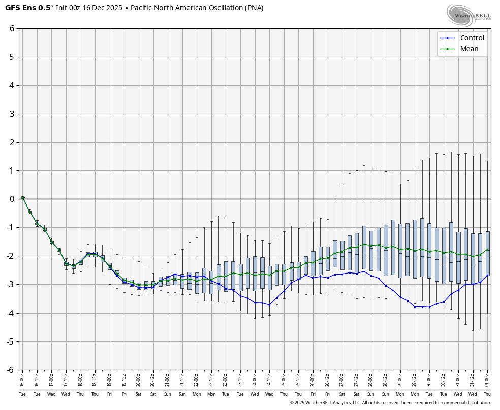
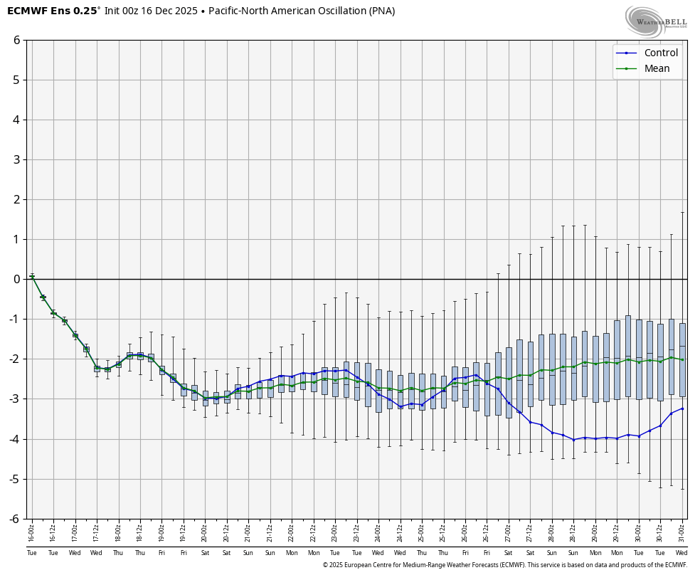
Note that this major evolution of the EPS over this one week period of runs has occurred with the Aleutian ridge not budging but at the same time the -NAO gets stronger and forces the rise of the PNA/big colder E US change from the NE!
-

Central PA Winter 25/26 Discussion and Obs
Eskimo Joe replied to MAG5035's topic in Upstate New York/Pennsylvania
1 inch of snow on the ground on 12/25. -

December 2025 regional war/obs/disco thread
Sey-Mour Snow replied to Torch Tiger's topic in New England
Figured -

December 2025 regional war/obs/disco thread
Damage In Tolland replied to Torch Tiger's topic in New England
That’s what the meltdown was about -
December 2025 regional war/obs/disco thread
Sey-Mour Snow replied to Torch Tiger's topic in New England
Just wait til 12z is congrats DC to Philly Friday and Monday .. they will all come back to bitch.. -

Central PA Winter 25/26 Discussion and Obs
mahantango#1 replied to MAG5035's topic in Upstate New York/Pennsylvania
PA Weather Plus, LLC ** LATE - WEEK POTENTIAL WINTER STORM ** Before I post today's blog post with the winter system expected tonight - Tuesday morning, I want to bring attention to the end of the week storm system, as there hasn't been a lot of talk about it. What originally looked to be a warm and dry Christmas and post-Christmas period, we are now watching the risk for a potentially more significant winter/ice storm to impact Pennsylvania. Right now, the coldest air is favored to be across central and eastern Pennsylvania, favoring either significant icing or snowfall. The CMC scenario currently remains the tamest, but still brings icing to northeastern Pennsylvania. I will continue to watch trends and bring you the latest updates throughout the week -stay tuned! -
Yeah, just wouldn't be surprised to see changes happen a couple or few days before the 15th is all I'm saying. Nothing crazy. That is a good point about the vortex too. Absolutely.
-
The issues began when the NWS left NYC back in 1993. The trees over grew the site and the temperatures started running cooler than the other stations. Then the snowfall began to regularly get under measured. This is why I have been leaning more on using EWR and LGA for snow and temperatures. There was some interest from the media over 20 years ago on the topic. More recently there was a crew that measured about 1” more last week and Sam Champion measured about 1” higher with another event in recent years. I calculated that if the trees didn’t over grow the site, that NYC would have closer to 28 to 29 days reaching 90° each year on average since 2010 instead of the reported 17 to 18 days. The under measurement for snowfall isn’t as great as the temperatures. The NYC snowfall average last 7 seasons is only -1.1” under LGA and -2.4” below Newark. So anyone using NYC for temperature and snowfall contests should consider switching to LGA and EWR. Central Park Weather: Vegetative Overgrowth Affecting Weather Readings - WABC-TV (New York-WABC, August 22, 2003) - Forecasting the weather is not easy. Government equipment can often be blamed for giving faulty weather information. As Bill Evans explains, a big culprit may be some of the equipment buried in Central Park. Rainfall, snowfall, and the temperature are all vital information recorded 24 hours a day at the weather station located in the heart of Central Park. But meteorologists like Michael Schlacter have serious concerns about the accuracy of the stations data. It sits amid overgrown vegetation and he says thats the problem. The leaves can trigger snow gauges and trees can warp rain and wind measurements. On this hot day, a temperature gauge is in the shade instead of direct sunlight. Michael Schlacter, Weather 2000: "Its kind of like driving a car without a speedometer, odometer, and gas gauge. You are running with false information." The weather instruments at Belvedere Castle have long adorned the top. There used to be a government meteorologist here in the city to keep an eye on them. But now the nearest meteorologist is 60 miles that way. But National Weather Service meteorologists say they knew the weather readings in the park would never be as keenly accurate as the ones at the airports where guidelines prevent foliage from being within 100 feet of the station. Schlacter: "We knew that at times we would have flaky readings, that leaves would fall in gauges, that we would have problems with visibility sensors." [NWS Meteorologist-in-Charge Michael] Wyllie says the weather station is there because it was historically significant to maintain its presence in the park. He says theres been a lot of growth because of the wet spring at so much in fact that temperatures have routinely been recorded lower in the park than at the airports. Wyllie: "We are actually having a micro climate system there because of the vegetation." Imperfect perhaps but nonetheless the system provides the official record of weather for the country's largest city. And Michael Schlacter says its a city that deserves better. Schlacter: "I think New Yorkers deserve a lot better, and I think they deserve the best weather station money can buy." Copyright 2003 ABC Inc., WABC-TV Inc.
-
December 2025 regional war/obs/disco thread
Damage In Tolland replied to Torch Tiger's topic in New England
That’s what I said to the melters -
GEFS AI 1 pm Friday is 38 degrees.
-
24.4° - got a bit lower than I had anticipated
-

E PA/NJ/DE Winter 2025-26 Obs/Discussion
anthonyweather replied to LVblizzard's topic in Philadelphia Region
I’ll take the euro. Bring on the mayhem . -
December 2025 regional war/obs/disco thread
Sey-Mour Snow replied to Torch Tiger's topic in New England
It's just very very odd to be near 8am and no weather posts, considering Friday's potential and Monday's trends if continued.. -

White Christmas Miracle? December 23-24th
UnitedWx replied to Baroclinic Zone's topic in New England
Same here. Just a couple inches would be nice -
Me as well. Over all these years I think I've only stayed up for the Euro a couple times, one was 2013 for sure. Shit, I barely ever stay up for the 0Z GFS... it's always there at 5 A.M.
-

December 2025 regional war/obs/disco thread
40/70 Benchmark replied to Torch Tiger's topic in New England
Weekends I always am, but only post if it's very interesting. -
Still looks better than that 70 did yesterday lol
-
(002).thumb.png.6e3d9d46bca5fe41aab7a74871dd8af8.png)
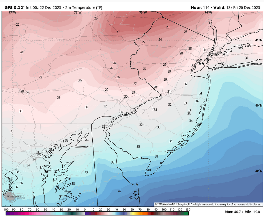
E PA/NJ/DE Winter 2025-26 Obs/Discussion
ChescoWx replied to LVblizzard's topic in Philadelphia Region
This may be the largest temperature swing over 1 run I have ever seen on a model. The other models have similar cold trends.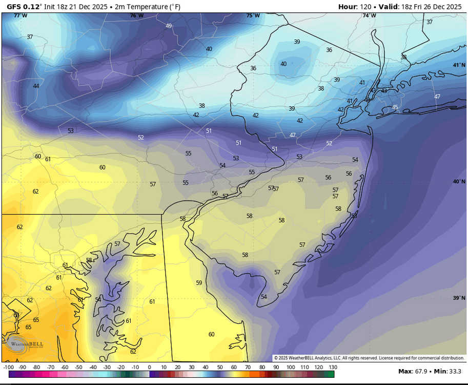
-
?? Did the posts get deleted?
-

December 2025 regional war/obs/disco thread
Kitz Craver replied to Torch Tiger's topic in New England
Why melt when things look to be improving? -
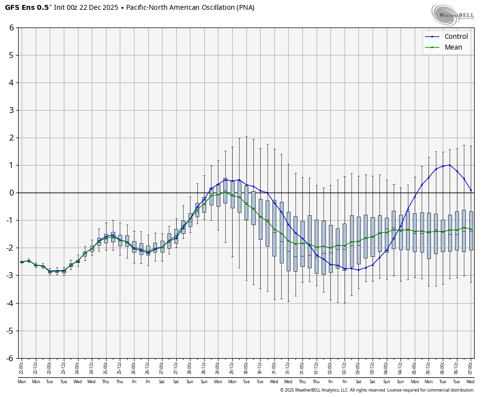
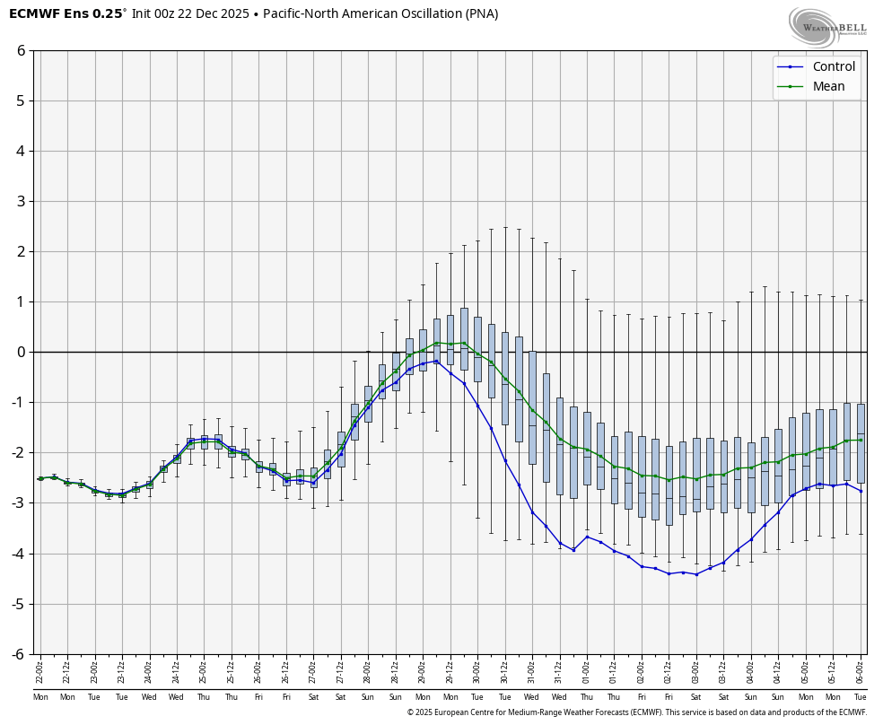
Look at how much the PNA has risen for a week from now: From ~-2 as of 2 weeks out GEFS: EPS: To ~0 one week out: GEFS: EPS:


-
December 2025 regional war/obs/disco thread
Sey-Mour Snow replied to Torch Tiger's topic in New England
I agree.. only a special storm for me will keep me up for euro -
WB 6Z GEFS. No support for operational run in the 5 day storm,