All Activity
- Past hour
-
Best weather in the Nation
-

Strong Nor'Easter/Hybrid Storm Late September 2026
uofmiami replied to Rjay's topic in New York City Metro
3.39” in Syosset. Have a large limb snapped up top & hanging on by a thread on one of my maple trees. -

2026-2027 Record-breaking El Nino
bluewave replied to Stormchaserchuck1's topic in Weather Forecasting and Discussion
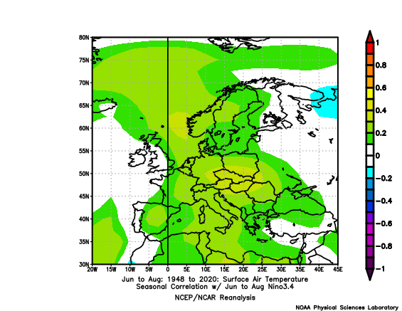
Not really when you consider the strongest El summer composite of 2023, 2015, 1997, 1982, and 1972 was cool in France which experienced the historic heat and drought this summer.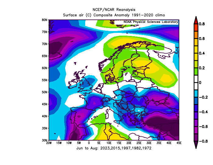
-
 Hmm.. looks closer than not to me
 -
Las Barrancas, Baja California Sur, Mexico looks like it could be close to the approximate landfall point for Hurricane Polo. It's a small fishing village with less than 1k residents.
-

October Comes Early: Late September Multi-Hazard Hybrid Storm
SouthCoastMA replied to WxWatcher007's topic in New England
5.15"..maybe a run at 6 if more develops -

October Comes Early: Late September Multi-Hazard Hybrid Storm
WinterWolf replied to WxWatcher007's topic in New England
So much for not putting much faith in the amounts…will you ever learn? -

October Comes Early: Late September Multi-Hazard Hybrid Storm
ScituateWX replied to WxWatcher007's topic in New England
5.58 here in Pembroke still pouring -
2026-2027 Record-breaking El Nino
bluewave replied to Stormchaserchuck1's topic in Weather Forecasting and Discussion
This was the reverse of the typical El Niño summer in Europe since the warmest anomalies were over Western Europe instead of Eastern Europe and Scandinavia.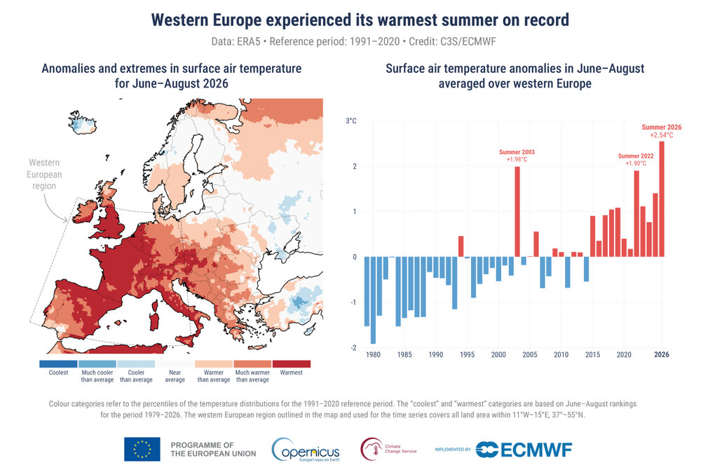
-

October Comes Early: Late September Multi-Hazard Hybrid Storm
40/70 Benchmark replied to WxWatcher007's topic in New England
NBD here...pretty boring. -

Strong Nor'Easter/Hybrid Storm Late September 2026
GaWx replied to Rjay's topic in New York City Metro
The new LGA update shows much longer delays than earlier with the quite strong winds along with lingering light rain/fog: LAGUARDIA ARPT LGT RAIN 61 59 93 NE30G47 29.54R FOG Due to WEATHER / WIND and WEATHER / WIND, there is a Traffic Management Program in effect for traffic arriving La Guardia Airport, New York, NY (LGA). This is causing some arriving flights to be delayed an average of 1 hour and 43 minutes. To see if you may be affected, select your departure airport and check "Delays by Destination". Delays by Destination: Due to WEATHER / WIND, departure traffic destined to La Guardia Airport, New York, NY (LGA) is currently experiencing delays averaging 1 hour and 43 minutes. General Departure Delays: Due to WX:Wind, traffic is experiencing Gate Hold and Taxi delays between 1 hour and 1 minute and 1 hour and 15 minutes in length and increasing. -
October Comes Early: Late September Multi-Hazard Hybrid Storm
40/70 Benchmark replied to WxWatcher007's topic in New England
I had .61" event total as of midnight. .03" Friday and .58" yesterday. -
September 27 1942: Minneapolis has a high temperature of only 40 degrees. 1898: A heat wave produces highs of 91 degrees at Beardsley and 90 at Moorhead. For Sunday, September 27, 2026 1816 - A black frost over most of New England kills unripened corn in the north resulting in a year of famine. (David Ludlum) 1959 - A tornado 440 yards in width traveled twenty miles from near Hollow, OK, to western Cherokee County KS. Although a strong tornado, it was very slow moving, and gave a tremendous warning roar, and as a result no one was killed. (The Weather Channel) 1970 - Afternoon highs of 103 degrees at Long Beach, CA, and 105 degrees at the Los Angeles Civic Center were the hottest since September records were established in 1963. Fierce Santa Ana winds accompanying the extreme heat resulted in destructive fires. (The Weather Channel) 1985 - A record early season snowstorm struck the Central High Plains Region. The storm left up to nineteen inches of snow along the Colorado Front Range, and as much as a foot of snow in the High Plains Region. (Storm Data) 1985 - Hurricane Gloria swept over the Outer Banks then rushed across Long Island, New England, and Canada. It was the first significant hurricane to hit New England in twenty-five years and brought heavy rains and high winds to the Mid-Atlantic states as well. 1987 - While those at the base of Mount Washington, NH, enjoyed sunny skies and temperatures in the 70s, the top of the mountain was blanketed with 4.7 inches of snow, along with wind gusts to 99 mph, and a temperature of 13 degrees. Severe thunderstorms developed along a cold front in the south central U.S. A thunderstorm west of Noodle TX produced golf ball size hail and wind gusts to 70 mph. (The National Weather Summary) (Storm Data) 1988 - Thunderstorms developing ahead of a cold front produced large hail in southeastern Wyoming during the afternoon, with tennis ball size hail reported at Cheyenne. Strong winds ushering the cold air into the north central U.S. gusted to 59 mph at Lander WY. (The National Weather Summary) (Storm Data) 1989 - Freezing temperatures were reported in the Great Lakes Region and the Ohio Valley. Houghton Lake MI reported a record low of 21 degrees. Thunderstorms in the western U.S. produced wind gusts to 50 mph at Salt Lake City UT, and gusts to 58 mph at Cody WY.(The National Weather Summary) (Storm Data) Observances: 27 Sun National Crush Day 27 Sun Gold Star Mother's Day 27 Sun World Tourism Day 27 Sun International Daughters' Day 27 Sun World Rivers Day 27 Sun Ancestor Appreciation Day 27 Sun Morning Show Hosts Day 27 Sun National AJ Day 27 Sun National Chocolate Milk Day 27 Sun National Corned Beef Hash Day 27 Sun National Scarf Day
-

Strong Nor'Easter/Hybrid Storm Late September 2026
Brian5671 replied to Rjay's topic in New York City Metro
would have turned to rain with the storm moving inland over NJ -

October Comes Early: Late September Multi-Hazard Hybrid Storm
jsw replied to WxWatcher007's topic in New England
Brattleboro, .10? Last hour it has been heavier off and on, so maybe .25 now. No rain gauge, going on KEEN totals. Not much in the way of wind. -
2026-2027 Record-breaking El Nino
40/70 Benchmark replied to Stormchaserchuck1's topic in Weather Forecasting and Discussion
Man, Cosgrove sounds aggressive....have 2014 a shoutout. -
Yup. Those are from last year that I picked up from a grower in Mass.
-
Dendrite is that from a grafted tree ? Those look just like the ones I’ve been eating.
-

October Comes Early: Late September Multi-Hazard Hybrid Storm
HIPPYVALLEY replied to WxWatcher007's topic in New England
Wow, you tripled up my totals. Not even .40” here. -
Looking forward to a nice 3 day return to summer. Could be our last 80 plus day?
-

2026-2027 Fall/Winter Mountain Thread
Maggie Valley Steve replied to BlueRidgeFolklore's topic in Southeastern States
Looks like our rain chances increase next weekend as moisture from Polo makes landfall on the Baja Peninsula spreads inland across Texas and combines with a strong Fall Cold Front and a surge of tropical moisture from the Gulf. Still a lot of details to iron out, but the potential is there for another heavy rainfall event followed by another push of cold air. Welcome to a strong El Nino Fall and Winter. This early September Nor'easter is a harbinger of things to come! -

Strong Nor'Easter/Hybrid Storm Late September 2026
winterwarlock replied to Rjay's topic in New York City Metro
1.27 2 day total imby -

Strong Nor'Easter/Hybrid Storm Late September 2026
nycwinter replied to Rjay's topic in New York City Metro
thank goodness this was not a winter storm all the people would be upset because we are in the dreaded dry slot.. -
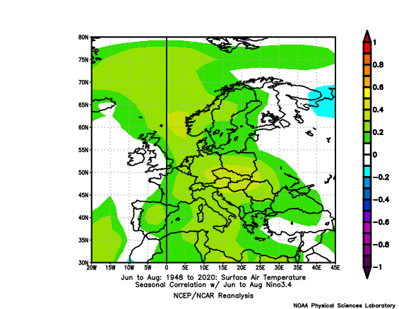
El Nino's are warmer Summers in Europe
-
 thanks, we work hard all offseason for this. No days off