All Activity
- Past hour
-

-
It is blazing out there but at least the dewpoint isn't in the 70's.
-

2026-2027 Strong/Super El Nino
bluewave replied to Stormchaserchuck1's topic in Weather Forecasting and Discussion
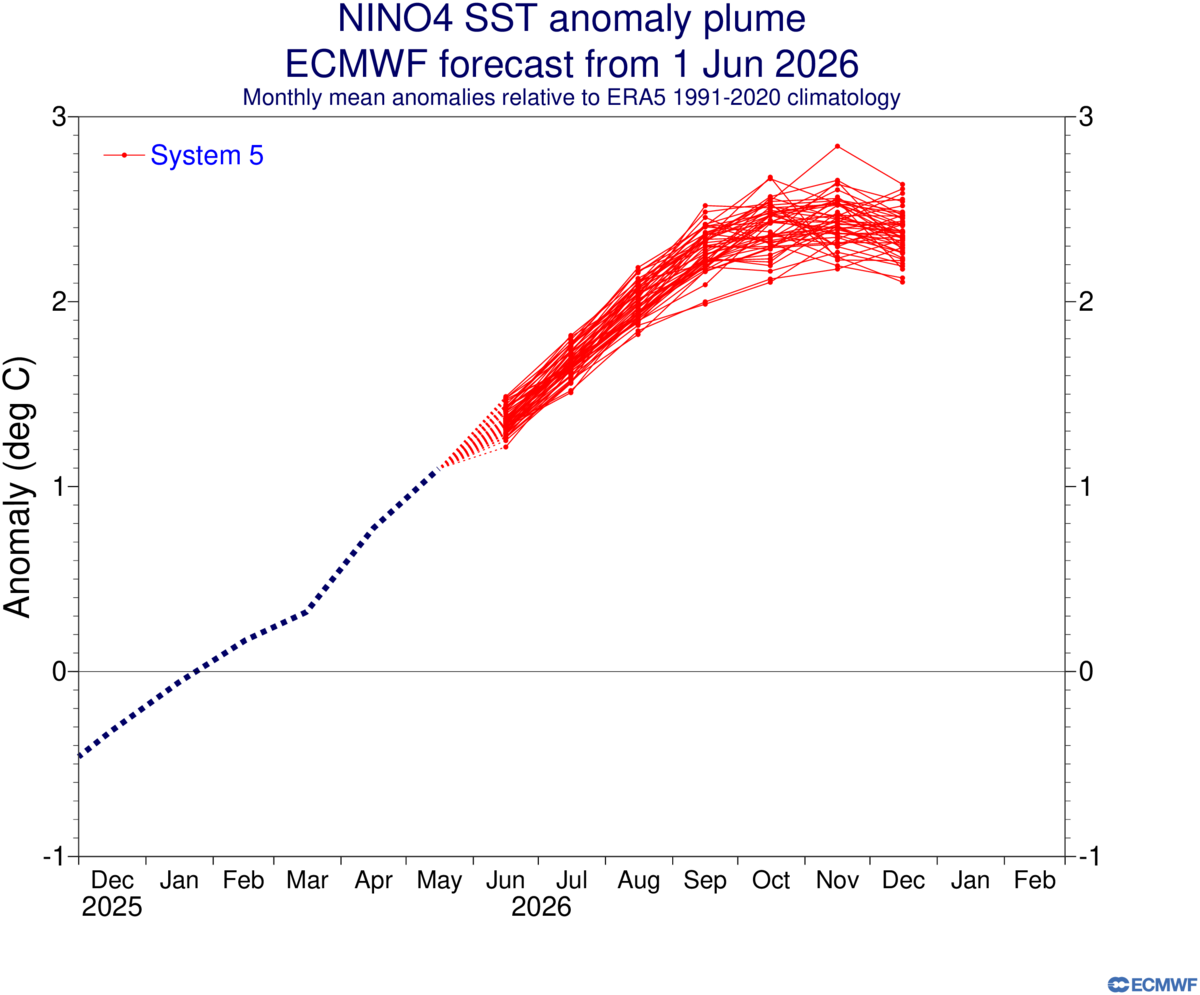
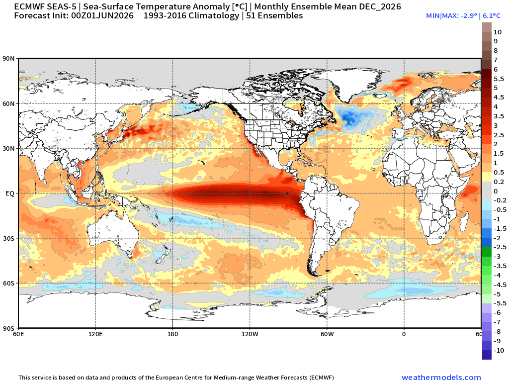
The core of the 30C + SSTs will probably shift over closer to MJO 7 and Nino 4 as the current forecast would surpass even 2015-2016 and 2023-2024 in those locations. The Euro has Nino 4 exceeding +2.0 which would be a first if it verifies. The previous Nino 4 record was 30.21C and +1.51 back in November 2023. Perhaps some areas could approach +31.0C. Even Nino 3.4 could get close to +30.0 C like in 2015-2016. The Euro has the warm pool east of Japan continuing. The IOD peaks in October and the SSTs near the Maritime Continent begin to rebound by December. So an historic and extensive area of extreme SSTs from the WPAC into the ENSO regions being forecast. https://www.cpc.ncep.noaa.gov/data/indices/ersst5.nino.mth.91-20.ascii 2015 11 23.93 2.28 27.95 2.84 30.13 1.44 2023 11 23.73 2.07 27.20 2.10 30.21 1.51
-
Cell in EC MN moving towards Hinckley has a strong hail sig. Complex moving into N WI. Looks like a miss S for me.
-
Looks like tonight may miss south too lol. Guess we'll try again on Sunday.
-

2026-2027 Strong/Super El Nino
csnavywx replied to Stormchaserchuck1's topic in Weather Forecasting and Discussion
We ain't getting a CP or "basin wide" event. Too much off-equator WWB activity, which focuses WWV onto the equator via Eckman transport and causes EKWs to break and surface later. If you want a CP/basin wide or w/e, you def want your bursts narrowly focused with some trade wind resistance like we had in the '99-'22 era. There was arguably a bit of that left in the '23/'24 event but we've had no issues killing off the trades, even well away from the equator. This is *much closer* to the '72-'98 environment in that respect. I can't be the only one who remembers how tough it was to kill off the trades even in the '15/'16 event. It languished for a while in the summer because of it and we had two false starts ('12 and '14) before that one took off. We are miles away from that. -

2026-2027 Strong/Super El Nino
GaWx replied to Stormchaserchuck1's topic in Weather Forecasting and Discussion
Indeed, Don, the Euro’s June prog has the strongest (“monster” as you said) on record. And I agree it’s looking E based. But it’s not currently looking nearly as E based as 97-8 based on peak fall/winter differences between 1+2 and 3.4/4 per the latest Euro. And it’s not even looking as E based as 1982-3 per these same differences. -
Currently 90F here, after an overnite low of 59F.
-
That supercell from Albany to New Haven still has to be one of the most classic left moving supercells on record
-
70 midday with low 60's dew. Feels good. A little rain has helped with RH levels.
- Today
-

Late May/June 2026 Medium/Long Range
SomeguyfromTakomaPark replied to JenkinsJinkies's topic in Mid Atlantic
Looks like the humidity arrives next week and will be sticking around- 135 replies
-
- 1
-

-
- we got burned
- rugpull central
- (and 1 more)
-
July 10, 1989, virtually no sun in SNE after late morning from a thick high OVC. Didn't matter. BDL went from 68 to 86 no problem and a 10 deg DP rise into the 70s almost all on advection once the warm front passed. A kiddie Scott had no idea a spinner would occur in Brockton that day!
-

2026-2027 Strong/Super El Nino
buckeye replied to Stormchaserchuck1's topic in Weather Forecasting and Discussion
back at ya, sometimes i miss the old days when subs based on geography weren't a thing. ...sometimes -
Scott shying away from his winter weenie passion?
-
12z GFS floods
-

2026-2027 Strong/Super El Nino
donsutherland1 replied to Stormchaserchuck1's topic in Weather Forecasting and Discussion
Yes. It's looking like a monster east-based El Niño event. -

2026-2027 Strong/Super El Nino
WX-PA replied to Stormchaserchuck1's topic in Weather Forecasting and Discussion
Not bad but that storm track could mean lots of rain..doubt there is much cold air with the Super Nino -
Agree with this 100%. When I did my presentation at the TriState Weather Conference back in 2022 I think it was on the November 13, 2021 tornadoes I mentioned having the higher dews advecting in ahead of the storms likely played a factor in not only destabilizing but because of the advection, the destabilizing was occurring more rapidly which can enhance updraft strength. One thing I'm also noticing too about tomorrow is a trend towards steeper mid-level lapse rates.
-
I think the only thing concerning to me is cloud cover. If that keeps temps down several degrees then expect less coverage. Otherwise, instability is modest….but lots of things advect in late day like higher 925-850theta-e, 500 PVA and falling temps, some better lapse rates etc. I like when things advect in vs already being in place. I think it helps destabilize. Just need to watch cloud cover.
-

2026-2027 Strong/Super El Nino
FPizz replied to Stormchaserchuck1's topic in Weather Forecasting and Discussion
Same for all the X posts that were wrong. You better go tell everyone! -
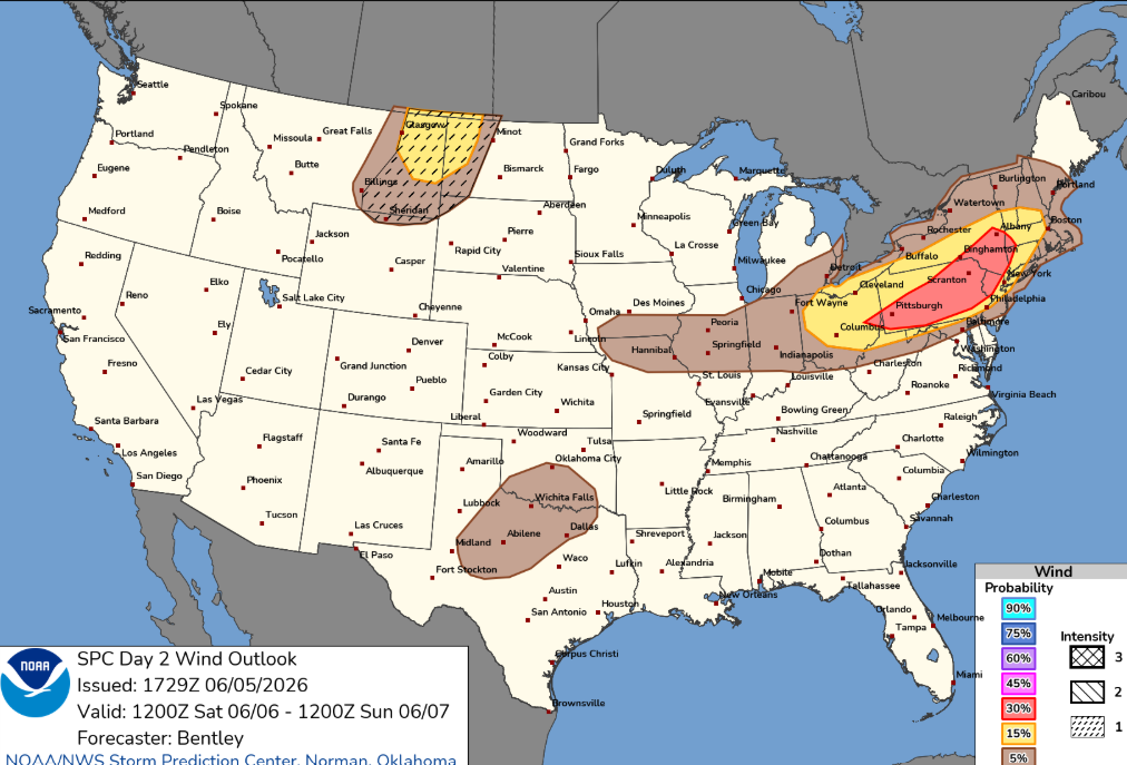
I wonder if we'll see a 30% wind area added in E NY into NW MA/SW VT. 12z bufkit soundings within this corridor look solid for wind potential with inverted V profiles and steep llvl lapse rates. One concern I have is potential for too much dry air in the mid-levels which may be a reason why CAMs aren't widespread with activity.
-
still haven't installed, these past few nights have been gloriously cool and perfect for sleeping.
-
hope we get a good soaker tomorrow or the lawns will be crying for wawa
-

2026-2027 Strong/Super El Nino
snowman19 replied to Stormchaserchuck1's topic in Weather Forecasting and Discussion
-

2026-2027 Strong/Super El Nino
SnowGoose69 replied to Stormchaserchuck1's topic in Weather Forecasting and Discussion
There is no question there is some type of correlation too, at least for places like AL/GA/MS/SC for the frequency to be higher during the cold AMO periods. That does not seem to be as much a factor for TN/NC/AR/OK/TX. But there is a higher peak, even in El Nino winters for those other 4 states in the 70s/80s and even during the more neutral or weaker warmer AMO period of the 40s/50s. I don't know if that is purely that colder outbreaks are more common then or perhaps/phasing amplified systems that cut north of them are less likely.