All Activity
- Past hour
-
Just saw a stat that the Vikings had 19 3rd or 4th downs and threw the ball on all of them. Just a terrible coaching day by KOC.
-
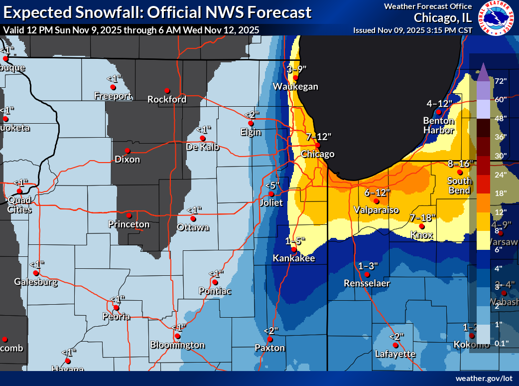
 Even if they only get half of those amounts, it it's still a nice amount of snow on November 10th and 11th for that area and I'm sure no one will complain. (I know we wouldn't complain if we were getting that right now)
 -

11/8-11/10 First Snow and Lake Effect Event
A-L-E-K replied to Geoboy645's topic in Lakes/Ohio Valley
Swirly af out over the lake right now -

November 2025 general discussions and probable topic derailings ...
CoastalWx replied to Typhoon Tip's topic in New England
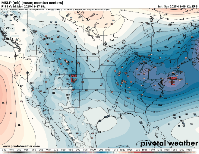
Yeah I’m not sure if those exorbitant amounts will be met. -

Occasional Thoughts on Climate Change
Typhoon Tip replied to donsutherland1's topic in Climate Change
Not sure if you're kidding or not but ... personally? I don't have a problem with him in general. He's had some really interesting guests on his program over the years, and has shown a type of journalistic curiosity in getting them to speak from their positions of expertise - open minded and genuinely inquisitive. When he's interviewed luminaries of a broad spectrum of disciplines ranging from the most esoteric physics, to the humanities and entertainment ... he's been fair, equally represented on both sides of the politics. He's just not right in his ideas with climatology. It's not a crime. One thing that he does not appear to be is abstinent when posed with logic that exposes what is objectively real - that's a key difference. -
Drop the PV over the hudson bay all winter long, ala 2013-2014.
-

November 2025 general discussions and probable topic derailings ...
dendrite replied to Typhoon Tip's topic in New England
Wraparound. Quick…somebody text Ray. -
Got to 75 here today. Still 62.
-
I will take it as small sign of progress if we can actually get a transfer to go south of Long Island for a change without getting suppressed to our south.
-

November 2025 general discussions and probable topic derailings ...
MJO812 replied to Typhoon Tip's topic in New England
Watch this timeframe for New England
-
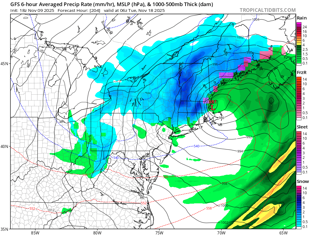
A storm brought snow from Chicago to Toronto earlier today. The stage is now set for a signifant to major lake effect snow event around Lake Michigan tonight into tomorrow. That storm will drag a strong cold front will across the region this evening and tonight bringing some showers and perhaps even a thunderstorm. Following its passage, an early taste of winter-like temperatures will be in store for a short time. As colder air drills into the region tomorrow, the temperature will fall through the lower 50s and through the 40s. A few rain showers are possible. Well north and west of New York City, some snow showers or snow flurries are possibe. Tuesday will be unseasonably cold. The temperature will rise from the lower 30s into just the lower 40s in New York City. Outside the City, widespread lows in the 20s are possible Tuesday morning. Wednesday through Friday will see highs mainly in the upper 40s to lower 50s. The Deep South could see the temperature fall to record low levels, particularly on Tuesday. Parts of Florida will likely see a freeze. The ENSO Region 1+2 anomaly was +0.1°C and the Region 3.4 anomaly was -0.6°C for the week centered around October 29. For the past six weeks, the ENSO Region 1+2 anomaly has averaged -0.05°C and the ENSO Region 3.4 anomaly has averaged -0.52°C. La Niña conditions will likely continue through mid-winter. The SOI was +7.95 today. The preliminary Arctic Oscillation (AO) was -1.495 today. Based on sensitivity analysis applied to the latest guidance, there is an implied 54% probability that New York City will have a cooler than normal November (1991-2020 normal). November will likely finish with a mean temperature near 47.6° (0.4° below normal). Supplemental Information: The projected mean would be 0.1° below the 1981-2010 normal monthly value.
-

2025-2026 Fall/Winter Mountain Thread
Buckethead replied to Buckethead's topic in Southeastern States
Down to 34° at 4400 in Wolf. 32° at 5000. Sent from my SM-S908U using Tapatalk -

11/8-11/10 First Snow and Lake Effect Event
Chinook replied to Geoboy645's topic in Lakes/Ohio Valley
another view -
 -40c at 500mb, with up to 1,000 j/kg of CAPE. Really amazing stuff. Check out the mini snow-canes developing over Lake MI.
 -

November 2025 general discussions and probable topic derailings ...
powderfreak replied to Typhoon Tip's topic in New England
Ha, high of 36F here with a slushy coating still on the ground on colder surfaces. -
Temps plummeted this last hour from 61 to 44 currently.
-
 Definitely some convective elements to this rain.
 -
November 2025 general discussions and probable topic derailings ...
dendrite replied to Typhoon Tip's topic in New England
Looks like they reeled that in some
-
November 2025 general discussions and probable topic derailings ...
dendrite replied to Typhoon Tip's topic in New England
Up to 38° here. Scorchah -

November 2025 general discussions and probable topic derailings ...
amarshall replied to Typhoon Tip's topic in New England
random deep deep boom in destructionbury. That was from a long way away. 40 miles of sound from the Wareham thunder. -
That storm blowing up on radar is crazy! Didn’t expect that today.
-
Some jagged lightning in the clouds and thunder east of Frederick.
-
.thumb.png.4150b06c63a21f61052e47a612bf1818.png)
November 2025 general discussions and probable topic derailings ...
HIPPYVALLEY replied to Typhoon Tip's topic in New England
Beers? -
Parts of the area were around 70° a few times in the last few days which were well above guidance from the forecasts 6-10 days ago which were too cold. I think what you are referencing about this week into mid-month is that we had a recent short term strong wave break leading to a strong block. So this drove a much stronger TPV into the Great Lakes with a colder forecast for the coming week. Once in a while we do get a colder period than originally forecast. But I am accurately describing that the core of the cold will miss the area again. Has nothing to do with lack of enjoyment or agendas. I don’t think that you have a warm agenda after making this post around a week ago. I am cutting you some slack since it was before the models started showing such a strong blocking pattern. So maybe you can find it in your heart to go easy on my description of the mid-month period before the recent model shift to colder with the stronger blocking. This is your post looks like a solidly above normal month ahead. Not by a lot, but it won’t be close to normal. New normal old normal whatever. if I still have my outdoor shower going at the beginning of November with no end date in sight, that’s a warm intro to winter
-

2025-2026 ENSO
Stormchaserchuck1 replied to 40/70 Benchmark's topic in Weather Forecasting and Discussion
^Such is consistent with strong -QBO Last year we had strong +QBO, and Nov-Feb had one of the stronger 10mb PV's on record. 2 years ago in strong -QBO, we had 4 Stratosphere warming events.