All Activity
- Past hour
-
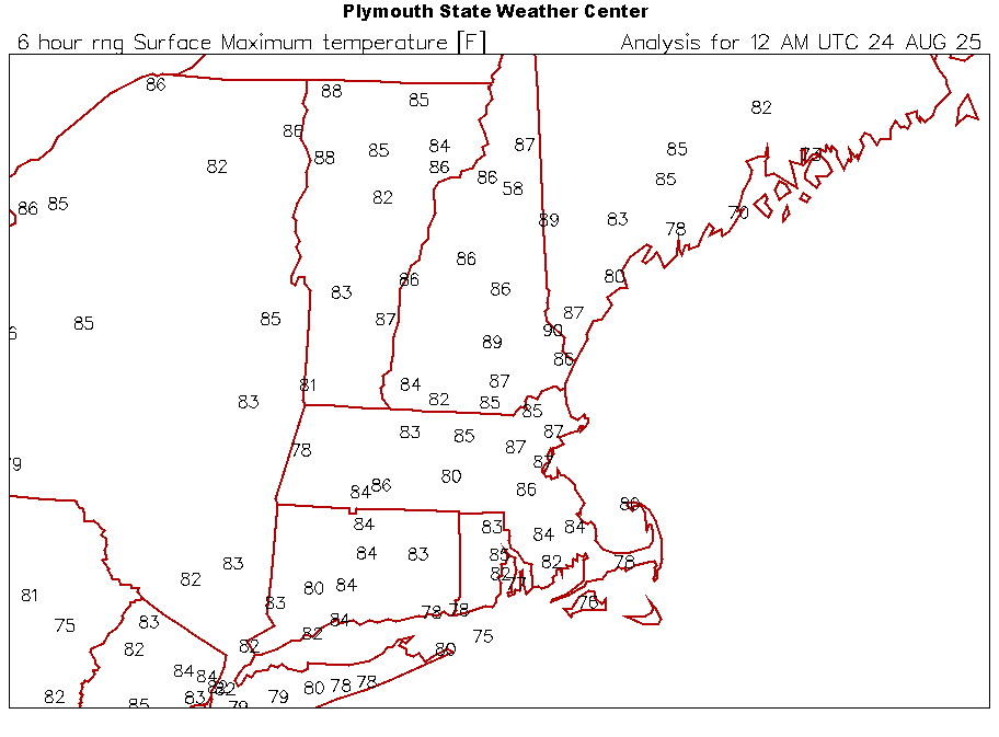
Highs today. Congrats Pope on the only 90°.
-
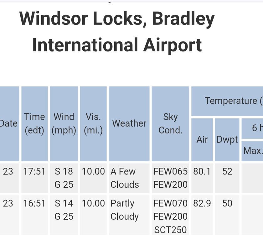
 Highs: EWR: 84 TEB: 84 New Brnswck: 84 PHL: 84 LGA: 82 NYC: 82 TTN: 82 ISP: 81 ACY: 80 BLM: 80 JFK: 79
 -
It's almost Thanksgiving! Then Chrismas and days getting longer. Almost there
-
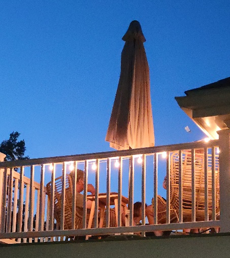
Pretty nice in the city if you have a deck.
-
Tropics dead
- Yesterday
-
I mean where people live.
-

2025 Atlantic Hurricane Season
Torch Tiger replied to BarryStantonGBP's topic in Tropical Headquarters
I don't read too much into that, personally. Some of the busier NE seasons were more fall-like in August, not speaking for "real" hurricane territory NC/FL -
East of the Windward Islands (AL99): Showers and thunderstorms have increased and are beginning to show signs of organization in association with a tropical wave located about 500 miles east of the Windward Islands. This system could become a tropical depression during the next day or two while it moves quickly westward at about 20 to 25 mph, passing through the Windward and Leeward Islands late on Sunday. Regardless of development, locally heavy rainfall and gusty winds are possible across portions of the Windward and Leeward Islands on Sunday and Monday. The system is expected to reach the central Caribbean on Tuesday, where conditions are expected to become less favorable for additional development. An Air Force reconnaissance aircraft is scheduled to investigate the system tomorrow, if necessary. * Formation chance through 48 hours...medium...40 percent. * Formation chance through 7 days...medium...40 percent.
-
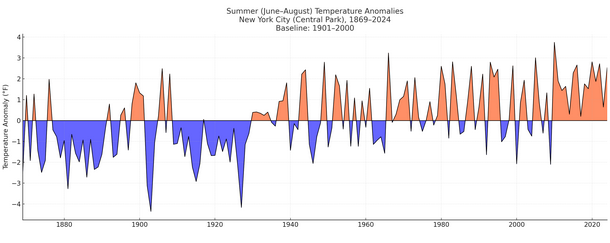
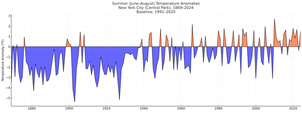
NOAA uses a 20th century (1901-2000) baseline for assessing anomalies for purposes of climate analysis. This is how NYC's summers look using the 20th century baseline: For purposes of "normals," the latest baseline period is 1991-2020. Here's how NYC's summers look using that baseline: The last summer cooler than the NOAA's long-term 20th century baseline was summer 2009. The last summer cooler than the 1991-2020 baseline was summer 2023. Summer 2025 will wind up warmer than both baselines.
-

2025 Atlantic Hurricane Season
NorthHillsWx replied to BarryStantonGBP's topic in Tropical Headquarters
With the anomalous trough and major fronts already impacting the east coast I would say the odds of an east coast impact from something other than home brew are likely decreasing. We’re in an October pattern in August -
Watch another low steal Gabrielle
-
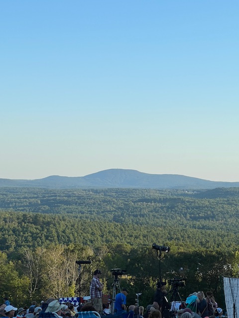
Only 80 at my house. Sorry. anyway, beautiful on the Mountain in Ashburnham
-
Glad we don't live there.
-
Ain't hot if you don't have the dews. Gorgeous evening!
-
Beautiful afternoon/evening today. Breezy, temp.of 78. Doesn't get much better than this in August.
-
Picked up .08" yesterday evening from showers. Everything is staying west so far today.
-
above normal temps and below normal snow. that's my official forecast for every winter for the rest of our lives
-

Mid to long range discussion- 2025
WinstonSalemArlington replied to wncsnow's topic in Southeastern States
-
 I'm 66, and still waiting...
 -

Arctic Sea Ice Extent, Area, and Volume
donsutherland1 replied to ORH_wxman's topic in Climate Change
Their goal, and that of other social media influencers, has nothing to do with honest discussion. It's solely about obfuscation. That's why they can only succeed in political circles, not scientific ones. Indeed, many of these influencers are viewed dismally in scientific circles. Their efforts are shoddy, filled with errors, and miss even basic points. I sometimes bring up some of them here, so that people are aware of what's going on. One example, not posted here, but on X: The basic error here that Martz (a social media influencer who is active in denying anthropogenic climate change and its impacts) makes is that he does not understand that probability measures the chance of an event occurring/not occurring. It does not directly measure model accuracy. Thus, he essentially endorses a post that asserts that a 5% probability of an event's occurrence means that he models were "wrong 95% of the time." This is a fundamental misunderstanding of what statistics measure and what they do not measure. Indeed, that fundamental error guides this inability to comprehend attribution science and its merit in explaining in statistical terms how much more likely and/or more intense an event was in the contemporary warmer climate. Unfortunately, many who are exposed to such content do not have the backgrounds or understanding to recognize that they are being misled.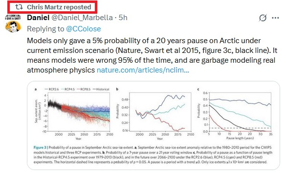
-
Back is decidedly broken. Sure we’ll get some heat but I’m sensing an early autumn. Rubber band snaps back warm in December.
-
I went to look up about it after it stopped and the internet was out for hours. Electricity was on but the internet was down.
-
 82 today. Beautiful day down at the marina
 -
High temperatures will top out mainly in the lower 80s tomorrow and Monday before another push of cooler air moves in. Following the arrival of the cool air, high temperatures will top out mainly in the upper 70s and lows will fall to lower 60s in New York City through at least Friday. Outside the City, lows in the 50s will be widespread. There will be higher-than-climatological risk of at least one period in September with highs in the upper 80s or perhaps 90s. Summers similar to the current one have had September highs of 90 or above about 10 percentage points above that for all other years. The ENSO Region 1+2 anomaly was +0.6°C and the Region 3.4 anomaly was -0.3°C for the week centered around August 13. For the past six weeks, the ENSO Region 1+2 anomaly has averaged +0.53°C and the ENSO Region 3.4 anomaly has averaged -0.20°C. Neutral ENSO conditions will likely continue into early autumn. The SOI was +15.90 today. The preliminary Arctic Oscillation (AO) was -0.352 today. Based on sensitivity analysis applied to the latest guidance, there is an implied 95% probability that New York City will have a cooler than normal August (1991-2020 normal). August will likely finish with a mean temperature near 74.2° (1.9° below normal). Supplemental Information: The projected mean would be 1.0° below the 1981-2010 normal monthly value.
-
not going to try and wishcast 99L like the last storm.. but there are some interesting ICON members and it did pretty good with Erin..


