All Activity
- Past hour
-

Extreme Cold, Snow & Sleet: SECS 1/25 - 1/26
nycsnow replied to TriPol's topic in New York City Metro
Minus nam and rrfs the short term models look like this -

1/23/26-1/25/26 Winter Storm Thread
WishingForWarmWeather replied to AMZ8990's topic in Tennessee Valley
I stocked up like the euro was the only model out there while praying things ended up like the gfs was the only model out there -

Extreme Cold, Snow & Sleet: SECS 1/25 - 1/26
jm1220 replied to TriPol's topic in New York City Metro
I’ve found that these models are too cold with these type storms this far out. By tonight it will have more of a clue. I’m going to look to see trends in how the snow gets here/how fast we pile up vs whether we (around the city) stay snow or change over to much sleet. That to me’s been decided. -

Extreme Cold, Snow & Sleet: SECS 1/25 - 1/26
wilton_wx replied to TriPol's topic in New York City Metro
RAP tends to be good at less than 20 hours, once it gets farther out its tough to tell. I think the NAM/GFS might be too progressive with the warm air. -

Extreme Cold, Snow & Sleet: SECS 1/25 - 1/26
donsutherland1 replied to TriPol's topic in New York City Metro
The RGEM is late. Again. Right now, taking into consideration the early 12z guidance, my thinking is that a reasonable worst-case (least snowy) outcome for New York City is 5" (no real change from previous thinking). A reasonable best case is 12" (down 2" from previous thinking). For now, I'm still thinking that a 6"-12" range for storm total snow and sleet captures the most likely scenarios. Well north and west of the City, 12"-18" still appears likely. Areas south and east of the City and its nearby suburbs down to the central Jersey Shore and on eastern Long Island are in line for 4"-8". As a note, I am not fixated on any single model. My thinking takes into consideration the full range. No model has been dismissed at this time. Moreover, 100% of individual EPS members had a 6" or greater snowfall. I do think that the 12z HRRR was too snowy for New York City, but we'll see what the later guidance shows. By 18z and especially 0z, differences among the various models should narrow dramatically. All in all, this will still be New York City's biggest snowstorm in nearly four or perhaps five years. Personally, given the long snow drought, including the record 1,456 consecutive days without a 4" or greater daily snowfall (that includes today), I'll gladly accept the outcome that appears likely. Of course, I appreciate even the smaller events. -

Extreme Cold, Snow & Sleet: SECS 1/25 - 1/26
Winterweatherlover replied to TriPol's topic in New York City Metro
Most likely yes except NJ coast and possibly southeast Suffolk. -
Extreme Cold, Snow & Sleet: SECS 1/25 - 1/26
nycsnow replied to TriPol's topic in New York City Metro
Backend snow included
-
Take 2 there small
-

Jan 24-26 Weekend Snow and Sleetfest Model Thread Part Tres
EastCoast NPZ replied to H2O's topic in Mid Atlantic
Im hanging my hat on that whatever falls will be around for a while. -

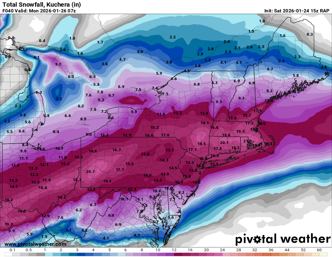
Extreme Cold, Snow & Sleet: SECS 1/25 - 1/26
MJO812 replied to TriPol's topic in New York City Metro
I agree. Im saying we dont know when that will happen. -

Extreme Cold, Snow & Sleet: SECS 1/25 - 1/26
SACRUS replied to TriPol's topic in New York City Metro
FWIW RAP - seems to always be the coldest in these situations 15Z QPF Sow (10:1) -
.thumb.jpg.ad3a2e31d30aff035044689b311a0540.jpg)
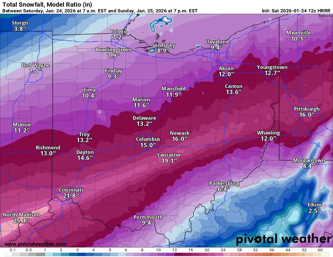
1/24-1/25 Major Winter Storm - S. IL, IN, and OH
nvck replied to A-L-E-K's topic in Lakes/Ohio Valley
20" of this falls Sunday calendar day, would easily be the highest all-time in cincy
-

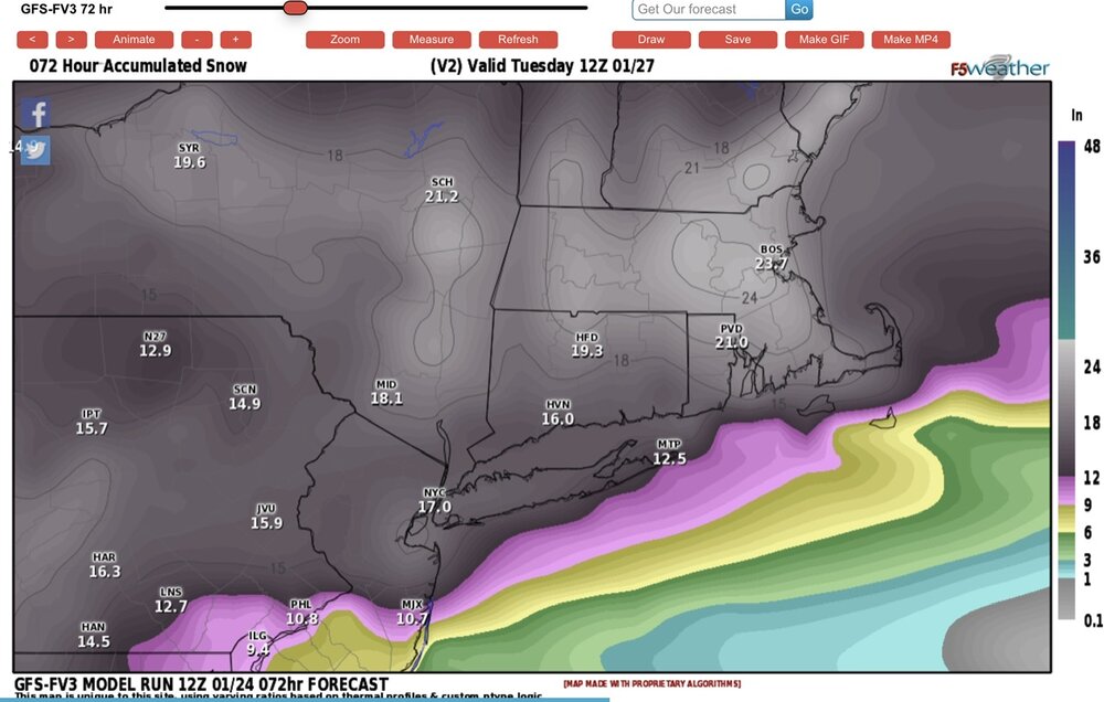
“Cory’s in LA! Let’s MECS!” Jan. 24-26 Disco
Torch Tiger replied to TheSnowman's topic in New England
misspoke...they are very juicy. lol i meant not too progressive or north with the sleet/mix line. that's a good sign. through 12z Mon
-
12z was snowier than 6z from overnight actually. It looks basically the same and is 100 miles south of the NAM .
-
fresh, powdery snow has the highest albedo of any surface. Light gets almost completely scattered. Ice and sleet are a bit more translucent if you look at them closely
-
Wow- the one time I’m rooting for a forecast bust! I like hot showers!
-
Extreme Cold, Snow & Sleet: SECS 1/25 - 1/26
MJO812 replied to TriPol's topic in New York City Metro
Dsny will most likely not pick up garbage on Monday . -
Extreme Cold, Snow & Sleet: SECS 1/25 - 1/26
Winterweatherlover replied to TriPol's topic in New York City Metro
Theres a primary pumping warm air and upper level lows tracking to the northwest, theres no reason for this not to change to sleet, it's not like it's even on the fence, the sleet line is to near I84 on the latest models. I am not saying we can't still get significant snow if the front end produces but the sleet is inevitable. -

“Cory’s in LA! Let’s MECS!” Jan. 24-26 Disco
Baroclinic Zone replied to TheSnowman's topic in New England
-

“Cory’s in LA! Let’s MECS!” Jan. 24-26 Disco
mahk_webstah replied to TheSnowman's topic in New England
Get your rest and weenie out Sunday night. You’re gonna get a great thump! -
Aren’t sending Reggie out?
-
1/24-1/25 Major Winter Storm - S. IL, IN, and OH
nvck replied to A-L-E-K's topic in Lakes/Ohio Valley
yeah, simref was misleading for a while, as dp depressions are still 10-15 degrees until late evening. not really expecting any snow accumulations until late this evening, when some moisture finally works in -
Extreme Cold, Snow & Sleet: SECS 1/25 - 1/26
MJO812 replied to TriPol's topic in New York City Metro
Sleet counts towards snow amounts . Its going to be cold tomorrow. -

Pittsburgh/Western PA WINTER ‘25/‘26
colonel717 replied to Burghblizz's topic in Upstate New York/Pennsylvania
We lost .1 from RAP. Getting nervous gonna miss us..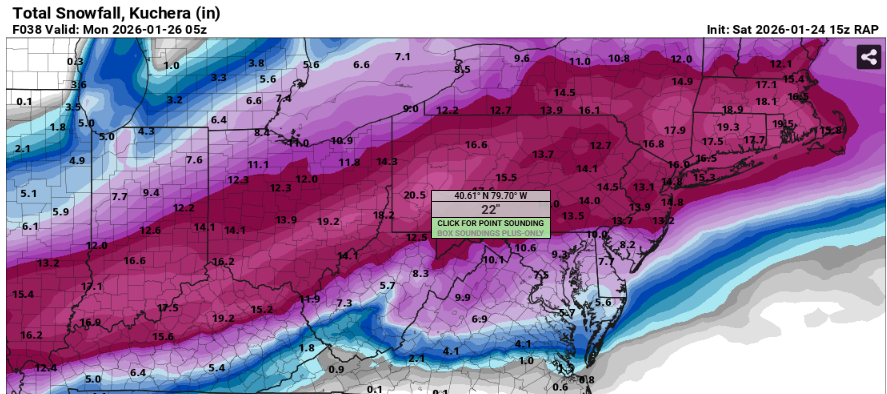
-

“Cory’s in LA! Let’s MECS!” Jan. 24-26 Disco
Damage In Tolland replied to TheSnowman's topic in New England
Yup