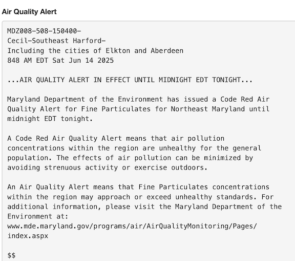
Records:
Highs:
EWR: 99 (1988)
NYC: 99 (1956)
LGA: 99 (1956)
JFK: 95 (2005)
Lows:
EWR: 49 (1978)
NYC: 49 (1875)
LGA: 51 (1978)
JFK: 52 (1980)
HIstorical:
1886: Many people were lost when high seas from a hurricane inundated the area near Sabine, TX. (Ref. Wilson Wx. History)
1903 - The Heppner Disaster occurred in Oregon. A cloudburst in the hills sent a flood down Willow Creek, and a twenty foot wall of water swept away a third of the town in minutes, killing 236 residents and causing 100 million dollars damage. (David Ludlum)
1953: The warmest June on record occurred in Oklahoma City, OK. The main part of the heat wave extended from the 11th through the 21st, and seven of the daily high temperatures during that stretch remain records for their respective dates. June 14th was the hottest day, reaching a toasty 106°. The other records ranged from 100° to 105°. Even the nighttime lows were records. Eight daily minimum temperatures from June 1953 are still record-warm daily minimum temperatures, ranging from 75° to 80°. (Ref. Wilson Wx. History)
1957: An F4 tornado moved across the south and southeast sides of Springfield, IL. The tornado destroyed 25 homes and severely damaged 175 others; property damage was around $3 million dollars. On the north side of town, the storms produced a wind gust of 98 mph at Capital Airport, which still stands as Springfield's record wind speed. Two people died during the storm, with over 50 others injured. A separate tornado touched down in downtown Jacksonville, destroying or damaging 40 buildings. East St. Louis, IL recorded the state record for rainfall in 24 hours with 16.54 inches. (Ref. Wilson Wx. History)
1961 - The temperature in Downtown San Francisco, CA, soared to 106 degrees to establish an all-time record for that location. (The Weather Channel)
1974: A tornado took an intermittent 53 mile long path across northwest and west central Illinois. The tornado first touched down just southeast of the Quad Cities, and moved southeast into Knox County. In Abingdon, 200 homes were damaged or destroyed. (Ref. Wilson Wx. History)
1987 - Thirty-two cities in the central U.S. reported record high temperatures for the date. The high of 97 degrees at Flint, MI, tied their record for June, and the high of 101 at Milwaukee WI marked their first 100 degree reading in 32 years. Thunderstorms brought much needed rains to South Texas, drenching McAllen with 3.2 inches in one hour. A thunderstorm soaked the town of Uncertain with 2.3 inches of rain in one hour. (The National Weather Summary)
1988 - Thirty cities in the eastern U.S. reported record high temperatures for the date. (The National Weather Summary)
1989 - Thunderstorms developing ahead of a cold front produced severe weather from the Central Gulf States to the Middle Atlantic Coast Region during the day and into the night. There were 62 reports of large hail and damaging winds. Thunderstorm winds caused 28 million dollars damage in Montgomery County MD. (Storm Data) (The National Weather Summary)
1990: Shadyside, OH was destroyed by a wall of water up to 30 feet high causing 26 fatalities. The flooding was caused by 4 inches of rain that fell in just 75 minutes. Localized, excessive rainfall fell on saturated ground over southeastern Ohio during the evening, resulting in a 15 to 20 foot wall of water that raced down three small tributaries of the Ohio River. (Ref. Wilson Wx. History)
1994: Norfolk: a bolt of lightning struck and critically injured a 50-year-old woman and a 38-year-old man playing in a golf tournament at Greenbrier Country Club in . Both suffered severe burns.
1998: On June13th and 14th Boston, MA had 5.99 inches precipitation the greatest in a 24 hours for June. (Ref. NOAA Boston Weather Events) and Atlantic, Iowa, set a state record for daily precipitation, measuring 13.18 inches of rain. (Ref. Wilson Wx. History)
2010: During June 14, training thunderstorms associated with a nearly-stationary cold front and an intense low-level jet brought torrential rains to the Oklahoma City, Oklahoma, area. Six to nine inches of rain in little more than three hours caused flash floods, resulting in more than three dozen water rescues. The North Canadian River at Oklahoma City rose from eight feet to over 21 feet almost instantly during the morning of June 14, Oklahoma City's wettest day on record (7.62 inches).