All Activity
- Past hour
-
What?
-
This is LWX's way of saying. " We have no clue" lol... However, the system that may impact the region towards the end of the week may have more cold air to work with. Won`t delve into details at this time, as it is a very complex upper-level pattern with lots of moving parts in the northern and southern branches of the jet stream. It is important to note that this period could also remain entirely dry as well, so nothing is set in stone yet at this point. Stay tuned to the latest forecast for more details as we get a little closer and have the pieces in place over the CONUS
-

December 2025 Short/Medium Range Forecast Thread
Carvers Gap replied to John1122's topic in Tennessee Valley
Apparently, I just need to miss the 12z suite for all **** to break loose. Shiver me timbers, GFS w/ a piece of the TPV! Storms on the Euro. -
Driving home around 9PM last night on the LIE in eastern Nassau County we encountered a blizzard of salt. It continued until we passed the spreader which was salting the highway for some unknown reason. This was traditional rock salt, not brine.
-

December 2025 regional war/obs/disco thread
WinterWolf replied to Torch Tiger's topic in New England
Impressive. But some insist that nothing is different from the last few years. And I get it…if you don’t have any snow, then whoopty Doo right. But I think we score something pretty soon. Edit: And that doesn’t even show the Virginia snow that fell there yesterday. So that percentage would go up a bit. -

December 2025 regional war/obs/disco thread
DavisStraight replied to Torch Tiger's topic in New England
Except for far southern New England where a lot of posters reside -
Hopefully the euro AI ensembles are direct vs EPS later in the 11-15 day. Supposedly they are more skillful on paper.
-
Insane ridge over Alaska. Going to keep dumping cold air on us.
-
12-13th might be an actual window to watch. nice to see the ridge out west trend taller, which helps shift the trough west as well

-
(002).thumb.png.6e3d9d46bca5fe41aab7a74871dd8af8.png)
E PA/NJ/DE Winter 2025-26 Obs/Discussion
ChescoWx replied to LVblizzard's topic in Philadelphia Region
Across Chester County the AM rain turned to Christmas PM snow with as 2" to 6" across the area depending on elevation. -
nice to see the ridge out west trend taller. helps the trough location and amplitude

-

December 2025 Short/Medium Range Forecast Thread
jaxjagman replied to John1122's topic in Tennessee Valley
Sure looks like the MJO is getting into the IO/Maritime No doubt about that,,big Artic High moving down from the Upper Plains -

December 2025 regional war/obs/disco thread
Typhoon Tip replied to Torch Tiger's topic in New England
Gotta love the Euro's rendition of that 20th beast... ruins Xmas by rolling up the entire electrical infrastructure into a giant fur ball, then vomits it out to sea. Here we go a pipes a-freezening
-

December 2025 regional war/obs/disco thread
brooklynwx99 replied to Torch Tiger's topic in New England
yeah, can see heights trending higher in the West and the trough inching into a better spot as a result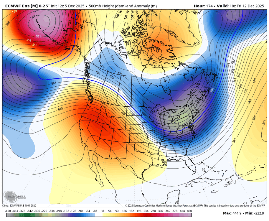
-
E PA/NJ/DE Winter 2025-26 Obs/Discussion
ChescoWx replied to LVblizzard's topic in Philadelphia Region
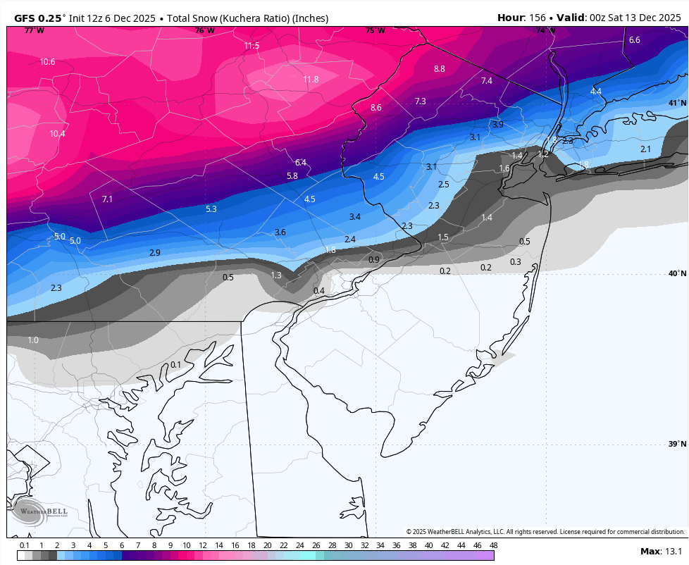
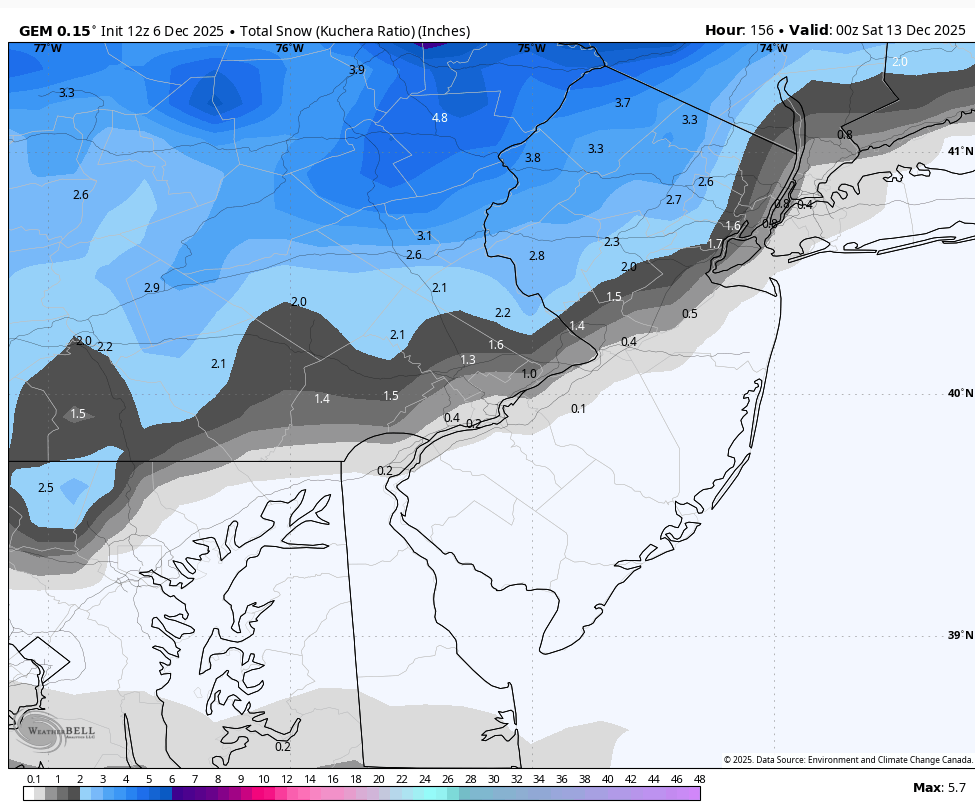
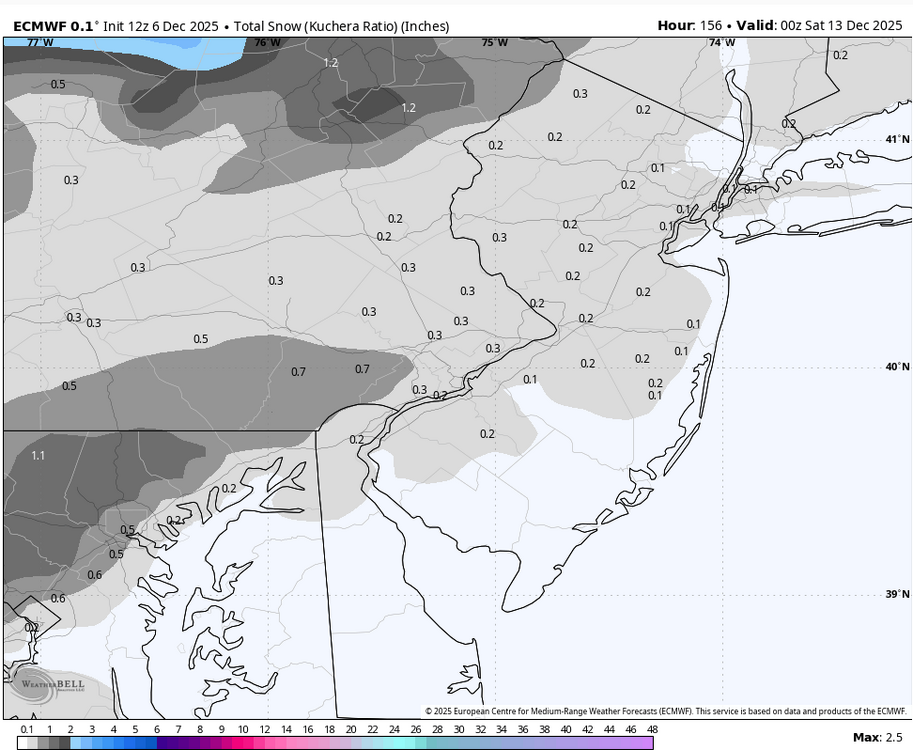
Our 4th potential winter event of the season could arrive by Thursday night. Models are starting to show this possibility. With the European currently the least enthused with the potential.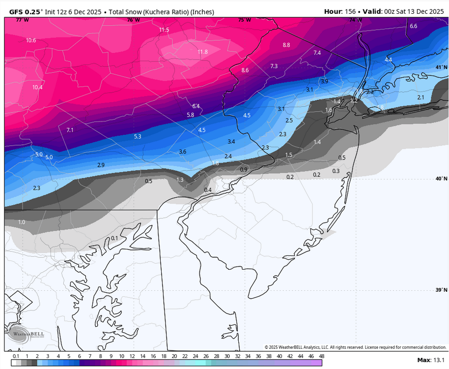

-
 No dustings here, but I did see a few sorry looking wet flakes mixed in with a quick shower that passed through around 8:30 this morning.
 -
12Z EURO and EPS both increased coverage/amounts for NC for Monday's small system. GFS still leads the way with highest amounts.
-
Long range doesnt appear really exciting but its showing something different each run.
-
Thank you!
-

December 2025 Short/Medium Range Forecast Thread
Matthew70 replied to John1122's topic in Tennessee Valley
Hopefully some clippers get into the flow. -
December 2025 Short/Medium Range Forecast Thread
Matthew70 replied to John1122's topic in Tennessee Valley
Definitely some cold air for next weekend. If we could just get an Alberta clipper to swing thru. Below average December looks to continue for the next 2 weeks -
The inverted came through. Pouring out
-

December 2025 regional war/obs/disco thread
TauntonBlizzard2013 replied to Torch Tiger's topic in New England
Pouring lol. Happy holidays -

December 2025 Short/Medium Range Forecast Thread
John1122 replied to John1122's topic in Tennessee Valley
The GFS is just ridiculously cold and dry as a bone. Shades of December '83 all over again. -
Slow down a bit and it'll churn up to include Baltimore.