All Activity
- Past hour
-
ever so slightly worse than 18z
-
Looks out to sea from what I can tell on pivotal
-
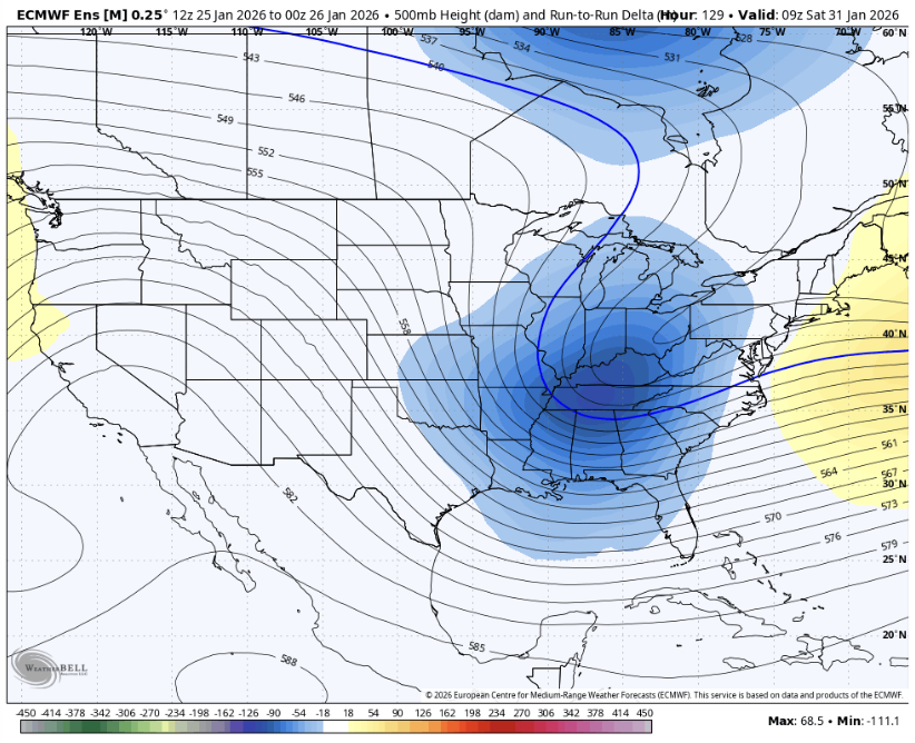
Cool change on the EPS
-
Shave 3-5 inches off for New England from the current storm and this is the next 2 storms combined from that Euro run:
-

January 2026 regional war/obs/disco thread
Ginx snewx replied to Baroclinic Zone's topic in New England
Another 15 to 20 on the Euro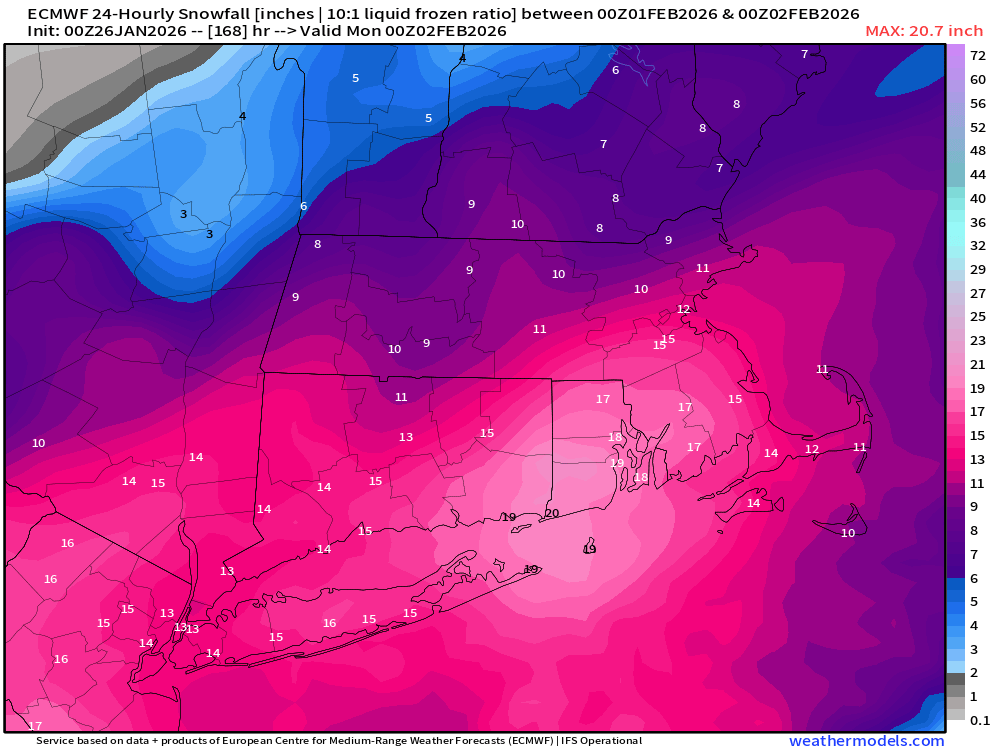
-

Richmond Metro/Hampton Roads Area Discussion
wasnow215 replied to RIC Airport's topic in Mid Atlantic
My gosh -
4.5” total so far Cleared before going to bed. Still got nice snow growth right now. Hopefully tonight and tomorrow produces.
-

Richmond Metro/Hampton Roads Area Discussion
chris624wx replied to RIC Airport's topic in Mid Atlantic
00z Euro has the coastal though it's not clean phase so some upper level energy gets held back and forms a secondary low just at the mouth of the Chesapeake. Interesting run. Someone will have to post maps because I'm on my phone lol -
Another bomb (1006-958) at h264 just sideswipes us
-
Richmond Metro/Hampton Roads Area Discussion
wasnow215 replied to RIC Airport's topic in Mid Atlantic
https://www.americanwx.com/bb/uploads/monthly_2026_01/793668986_Screenshot2026-01-26at1_01_11AM.png.ef0598f21fe2218e3283cf58efad6dae.png -
 4.5” total so far Cleared before going to bed. Congrats to everyone that got smoked.
 -
.thumb.png.4150b06c63a21f61052e47a612bf1818.png)
January 2026 regional war/obs/disco thread
HIPPYVALLEY replied to Baroclinic Zone's topic in New England
We 2015 -
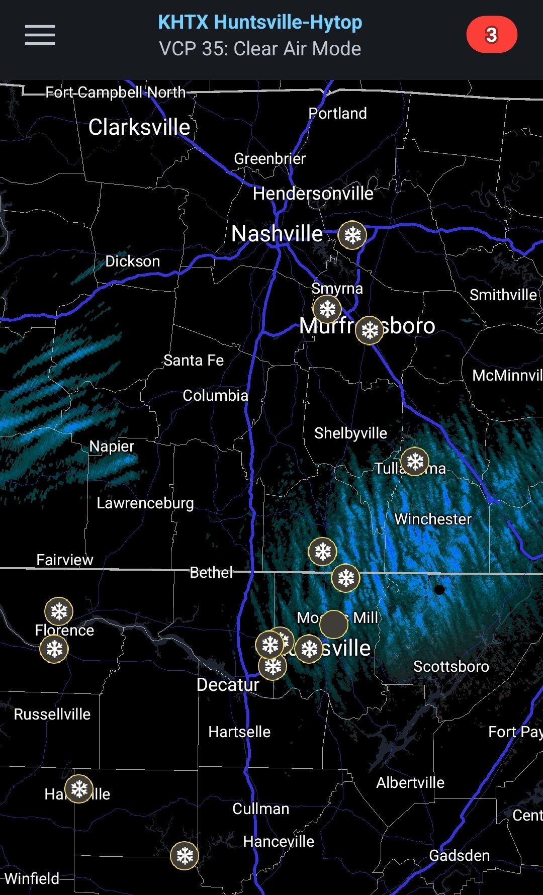
 Ummm...what is HUN radar picking up. Snow streaks to west are moving sw to NE...ones at radar are moving NNW to SSE...
-
check out the LR thread yall
-
EPS-AI looking better at h5... snow maps TBD
-

E PA/NJ/DE Winter 2025-26 Obs/Discussion
CoolHandMike replied to LVblizzard's topic in Philadelphia Region
THE F***??? -

Southern MD / Lower Eastern Shore weather discussion
AlexD1990 replied to PrinceFrederickWx's topic in Mid Atlantic
Um, guys....0 z eruo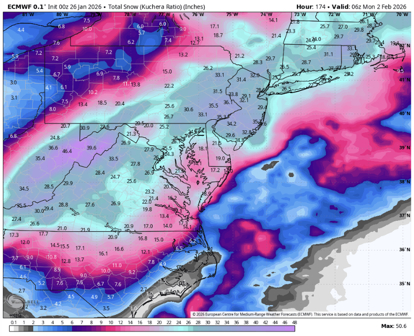
-
Not counting lake effect nonsense, we got probably 4x what Chicago got. I never lose.
-
-

E PA/NJ/DE Winter 2025-26 Obs/Discussion
LVblizzard replied to LVblizzard's topic in Philadelphia Region
All the other globals have it too but none of them tuck it in like the Euro. Gonna be more sleepless nights ahead looking at these models. -

Texas 2026 Discussion/Observations
Snowstorms replied to Stx_Thunder's topic in Central/Western States
Down to 12 here in Haslet. Everything is rock solid ice out there. -
This is a thing of pure beauty. All I have ever wanted, is for there to be such a massive snowstorm over the DMV, that simply demolishes with incredibly heavy snows, and this looks so transcendently resplendent in all its Glory! It's got its frigid, moisture laden, highly energetic eyes fixed on DCA.
-

-
Is it bad I'm looking at the 34" in NJ and getting jealous
-

January 2026 Medium/Long Range Discussion
NorthArlington101 replied to snowfan's topic in Mid Atlantic
We may never get above 32 degrees again