All Activity
- Past hour
-

2026 C and E Pacific tropical activity
WxWatcher007 replied to GaWx's topic in Tropical Headquarters
I’m a sucker for center passes but you are right. The RFQ is hitting dead on. It’s going to be a rough ride for them. -
 Viagra online price or cheap viagra Viagra tablet online https://www.google.com.sb/url?q=https://mencarevirtual.shop cheap viagra or https://virtualchemicalsales.ca/user/ckgxxjudnn/?um_action=edit sildenafil online [url=https://www.google.cm/url?sa=t&url=https://mencarevirtual.shop]Viagra tablet online[/url] Generic Viagra for sale and [url=https://exhibitioncourthotel4.co.uk/user-2/etzzvufezr/?um_action=edit]buy Viagra over the counter[/url] Viagra online price
 -
http://mencarevirtual.com/# viagra canada
-
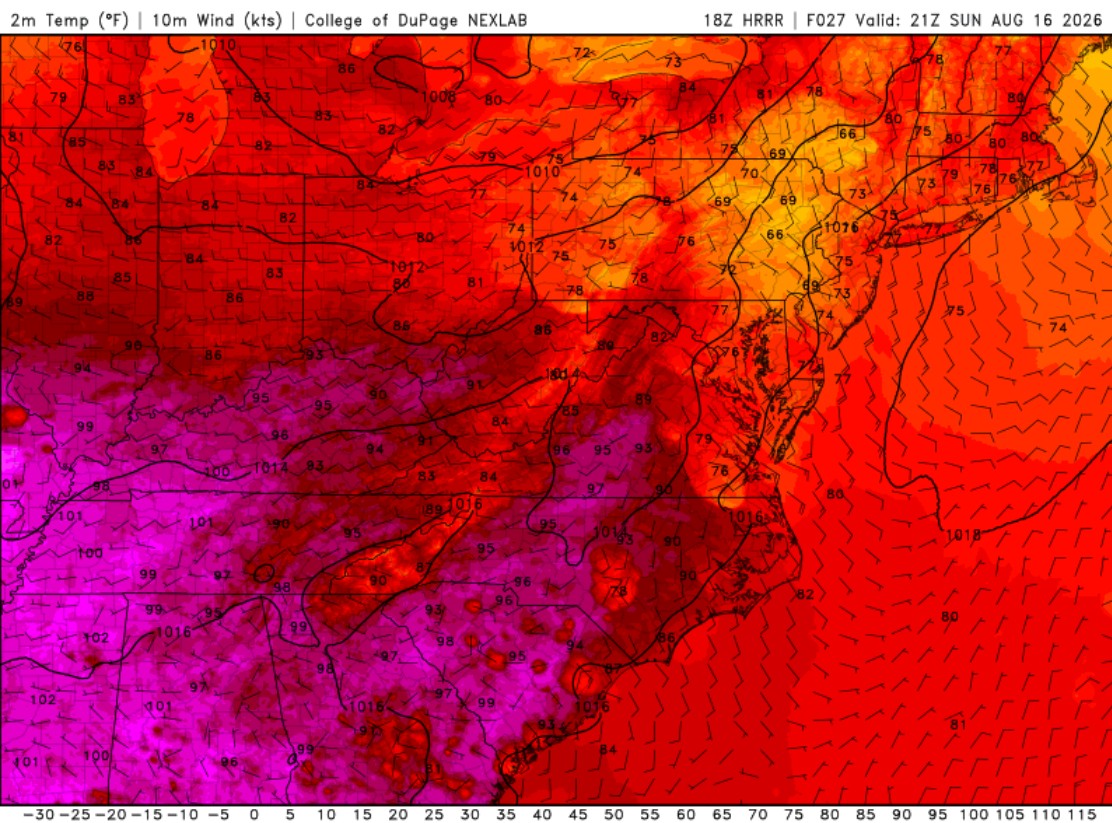
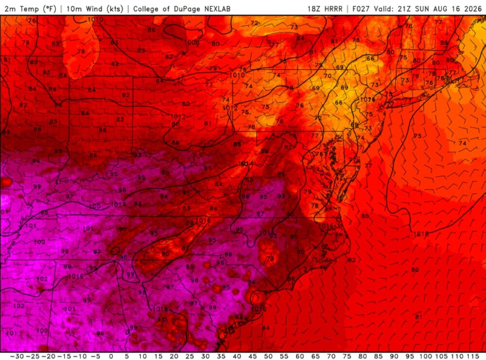
I am thinking the dew point advection will be enough in the aftn. They all show a finger of high CAPE (HRRR shows up to 4500, but that seems overdone, GFS and ECMWF have 2500 max) to n-cntrl VA, stopped just W of DC (really close, only about 20 mi W). So there is good CAPE available, just not widespread. It appears there will be a N-S warm or stationary front bisecting VA Sun aftn. Look at the HRRR fcst for 21z Sunday. That is quite a temp gradient, and such a boundary is ripe for tornadogenesis. Any storm crossing or latching on to such a boundary can go tornadic very quickly. Even on the cooler side, it can be favorable a short distance in b/c the cooler air is very shallow so a supercell is still effectively sfc-based.
- 1,912 replies
-
- 2
-

-
- severe
- thunderstorms
- (and 7 more)
-
Apparently it was completely clear last night but I was too tired to stay up and look. I wonder what the rate would have been two nights after peak? The Perseids drop off rapidly after peak and I've never tried to look two nights after the peak.
-
That's why I've been wondering if the el nino really becomes historic if the bake off summer will be in 2028 rather than 2027. This one might be more like 1998 rather than 1983.
- Yesterday
-
Viagra without a doctor prescription Canada: MenCare - Cheap generic Viagra online
-
I cant help but think this is nature's way of dealing with climate change. In an ironic twist more smoke from wildfires, more flooding rains and more of a sea breeze at the coast have all resulted in less extensive and sustained coast to coast extreme heat than what we observed during the 80s and 90s in the specific years I outlined above. Do you think the planet has a heat ceiling that is close to being reached during the summer beyond which it physically can't get any hotter? The slower rise of temperatures in the summer hint at this while winter and other seasons warm faster. Also faster warming rates the farther north you go where the heat ceiling is higher even in summer. I think we'll eventually approach heat entropy when the temperature difference between the poles and the tropics is lower than it's ever been before.
-
I'm on the schedule to get the deck boards replaced in early October it looks like at this point. See how it goes. Could put off the finish until Spring if necessary, NBD. But yeah lets schedule an estimate sometime before you go off on your winter snow chase. Jealous!
-
Mr. J won tickets to see the NSO at Wolf Trap tonight. Occasional slight breeze but sticky night.
-

2026-2027 Record-breaking El Nino
JACKASS replied to Stormchaserchuck1's topic in Weather Forecasting and Discussion
Not? -
1988 had such an incredible hot summer, this is an example of what I mean when I say the heat was much more extensive and longer lasting in the 80s and 90s in the summer than it is now. This has nothing to do with Central Park foliage issues this was literally coast to coast heat that lasted the entire summer. Other examples include 1980, 1983, 1988, 1991, 1993, 1995, 1999, 2002. By the way in yesterday's post you mentioned that Boston's all time August high of 101 happened in 2002?
-
Missing landfall by inches is worse. The big island is square in the right front quad and not much weakening happens.
-
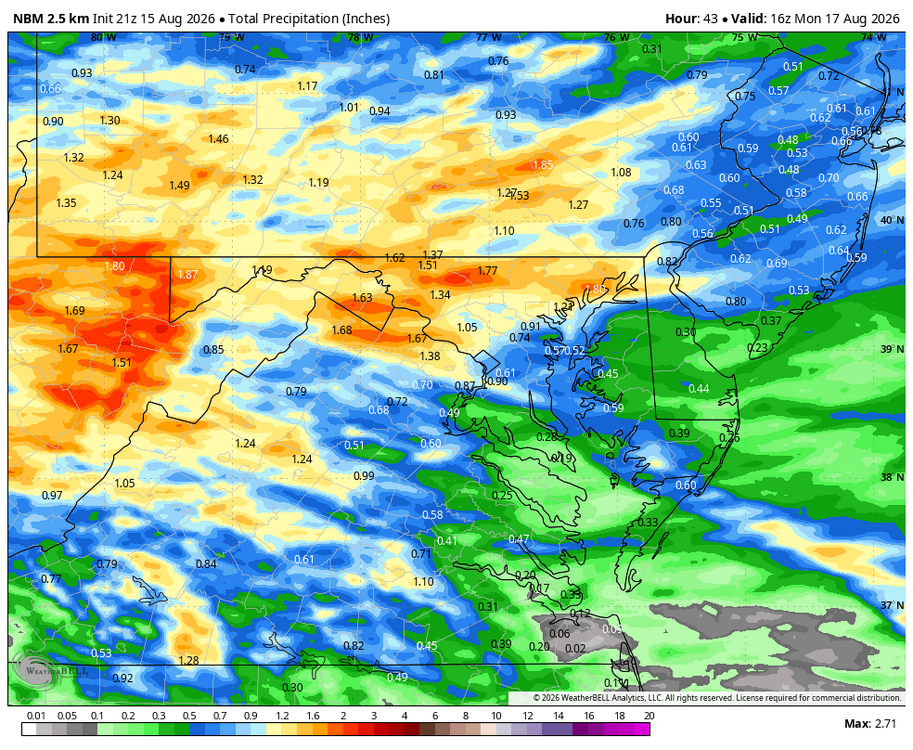
This looks nice Will !! I guess I can look forward to 1.40" rain the next 40 hrs. That's more than the total for the first half of August!!
-
Augdewst 2026: Summer's Last Stand
WxWatcher007 replied to Prismshine Productions's topic in New England
-
2026 C and E Pacific tropical activity
WxWatcher007 replied to GaWx's topic in Tropical Headquarters
G140 reported at Mauna Kea Summit!! Likely to be a close miss with regard to official landfall for the big island but some significant impacts showing up on damage reports across Hawaii. -
No argument. It's boring.
-
She has Central AC. It gets hot, which is looking more and more unlikely I'll just head over.
-

2026-2027 Record-breaking El Nino
ncjoaquin replied to Stormchaserchuck1's topic in Weather Forecasting and Discussion
It took you a decade and 30,000 plus posts to determine that nobody knows anything. You are sharp! -

2026-2027 Record-breaking El Nino
40/70 Benchmark replied to Stormchaserchuck1's topic in Weather Forecasting and Discussion
That looks centered on the PNW/SW Canada...could be worse. NAO-east, too. -
2026-2027 Record-breaking El Nino
40/70 Benchmark replied to Stormchaserchuck1's topic in Weather Forecasting and Discussion
He does not know his shit, which is why the nonsense-troll MO is so frustrating. ...every now and then, I get a DM from him on actual weather in the lead up to a huge event. -
Augdewst 2026: Summer's Last Stand
WxWatcher007 replied to Prismshine Productions's topic in New England
Man we need tropical -
Shes going to leave you once she finds out you uninstalled...
-
I figure I'll be in a good location. I can get to the entire NE coast in less then 8 hours drive. I can hit the coast of Maine or head all the way back down here in less then 8 hour. I'll be up at Barns Corner watching like a hawk. There's going to be some big storms somewhere this winter. I plan on being in the jackpot for most of them. My goal is 300" this season.
-
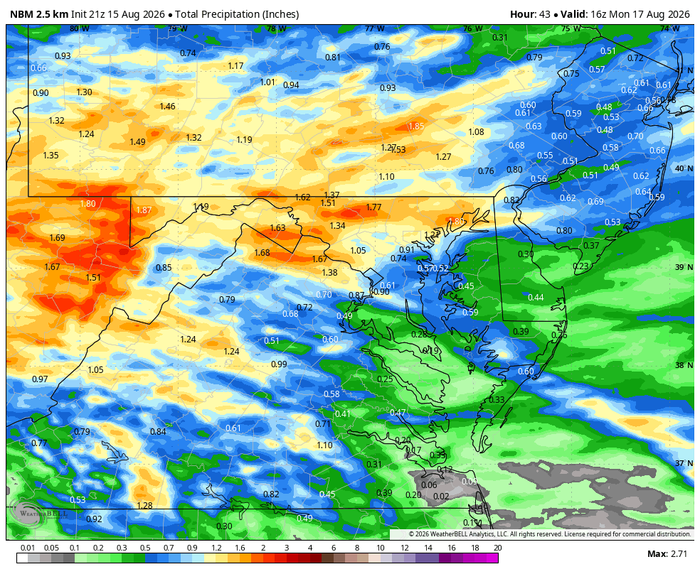
WB 21Z NBM for upcoming rain event.