All Activity
- Past hour
-
That actually reminds me of February 1989
-
omg I've never experienced anything like that, in 1993 we had 3 straight days of 100+ which peaked at 102 on the third day and that was my best heatwave ever.
-
I think the haze/smoke is worse today than any of the days last week. Even the close in mountains have a hazy look, and unless I'm imagining it again, can sometimes smell a little smoke. Especially when I first walk out of the house.
-
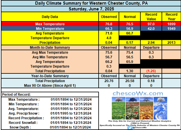
only .04 from any rain the past 2 days recapping last week, my highs Thurs-Sat were 88, 89, 89 and 80 yesterday....still without a 90 this year. bad weekend weather pattern looks like it will continue next weekend
-
I don't doubt it. Sun angle popped into my head as a joke since we hear so much about it here but there could actually be something to that. The sun is actually out a bit up here this morning, I wonder what's wrong.
-
Hmmm FXUS61 KLWX 081335 AFDLWX Area Forecast Discussion National Weather Service Baltimore MD/Washington DC 935 AM EDT Sun Jun 8 2025 .SYNOPSIS... A cold front will slowly settle southward toward the area through today, then meander across the Mid-Atlantic through Monday. A stronger cold front will cross the area on Tuesday night, followed by high pressure Wednesday and Thursday. && .NEAR TERM /THROUGH TONIGHT/... Next shortwave trough and accompanying area of low pressure will track ewd from eastern Ohio and across Pennsylvania this afternoon providing ample lift for showers and thunderstorms in a warm, humid, and unstable air mass. As of this morning, the wavy stalled front is located generally from Staunton to the Northern Neck. Cloudy and showery conditions continue north of this boundary this morning, with a few embedded heavier showers ongoing in central VA. This activity is expected to slowly diminish by early afternoon as the warm front lifts north into our area. Where the front ultimately stalls will be important for the severe/flood threat. The most unstable airmass is likely to be south of US-50. The early 12Z guidance looks to have the warm front along the Potomac River, possibly some of it stretches up into MD just south of I-70. The greater SRH will be along and east of the boundary, though deep-layer shear of 35-45 knots looks to be plentiful across most of the area. Will be looking to see where these gradients ultimately set up as that will point to the corridor of most likely severe weather.
-
First bust of the summer?
-
Gorgeous outside!!
-
Haha It's the Sun, the breeze, the temp and the dewpoints all screaming "beach" for some reason, at least to me down here by the coast.
- Today
-

2025-2026 ENSO
michsnowfreak replied to 40/70 Benchmark's topic in Weather Forecasting and Discussion
This is the deadliest heatwave on record in the U.S. Detroit saw temps over 100° for 7 straight days (peaking at 104 on day 1 and 7). The city allowed people to sleep in parks since their homes/apartments were baking. The MI state record was set in Mio with a temp of 112°. -
The sun angle
-
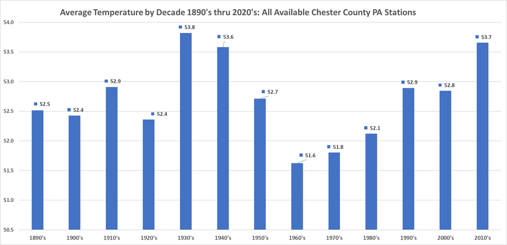
Funny how Charlie picks his starting point as 1970...I wonder why?? Oh wait I see it below - he starts with our coldest decade...cyclical climate change FTW!!
-
Font / boundary pushed south with the main area of rain and heavy rain into SPA W-MD/VA - creeps back Mon night / Tue wit our next widespread showers, rains, storms
-

2025 Lawns & Gardens Thread. Making Lawns Great Again
DavisStraight replied to Damage In Tolland's topic in New England
Every dog I've had (4 dogs) except for the current pup have been sprayed, nasty smell but I keep hydrogen peroxide, baking soda and dawn in the house just in case. -
Something about this morning's weather feels like beach weather right now
-
-
The ECMWF site provides them. The most skill is week 1 followed by week 2.But the 3rd week out and beyond are often very low skill. https://charts.ecmwf.int/?facets={"Product type"%3A[]%2C"Range"%3A["Sub-seasonal"]%2C"Parameters"%3A[]%2C"Type"%3A["Forecasts"]}
-
First week of June Dep Thru Jun 7th: EWR: +1.9 (0.57) JFK: +1.7 (0.33) NYC: +1.1 (0.72) LGA: +1.1 (.30)
-

2025 summer max contest -- enter by 06z June 23
RickinBaltimore replied to Roger Smith's topic in Mid Atlantic
DCA - 99 IAD - 98 BWI - 98 RIC - 99 -
Today and Monday will be cooler than the last few days with temperatures remaining 6 to 8 degrees below normal for June. Highs on both days will be not too far from 70 degrees with some higher ridge locations staying in the upper 60's. Shower chances are around today through Tuesday morning before we clear out and warm up by Wednesday. By Wednesday temperatures should return to near normal with highs near 80 degrees with temps rising to the mid 80's by the end of the new work week.
-
Records: Highs: EWR: 99 (2011) NYC: 95 (1933) LGA: 97 (2011) JFK: 96 (1999) Lows: EWR: 44 (1932) NYC: 47 (1932) LGA: 50 (1977) JFK: 50 (1997) Historical: 1885: A killing frost occurred at Fargo, ND. This date remains the latest on record. (Ref. Wilson Wx. History) 1920: Yosemite Valley, CA plunged to 14°; their coldest June temperature on record. (Ref. Wilson Wx. History) 1950: Two inches of snow fell at Billings, MT. This is their latest measurable snowfall on record. The high for the day was only 42°, a record low maximum. (Ref. Wilson Wx. History) 1951: A tornado was captured on motion pictures for the first time in the USA. 1953 - The worst tornado of record for the state of Michigan killed 116 persons. Flint MI was hardest hit. The tornado, half a mile in width, destroyed 200 homes on Coldwater Road killing entire families. (The Weather Channel) 1957: A tropical storm moved in from the Gulf of Mexico and crossed northwest Florida, spawning a tornado outbreak and flooding rainfall. Five people drown in the Gulf of Mexico when a small fishing vessel capsized in high seas. A shrimp boat was sunk off Ft. Myers, and several other boats were driven ashore south of Tampa. At least 9 Tornadoes were reported in Alachua, Marion, Clay, Putnam, and Duval counties (Jacksonville area). Tornadoes damaged roofs and uprooted trees. Heavy rains of up to 19" in 48 hours caused much local flooding and considerable agricultural damage, closed many roads and washed out several small bridges. Two hundred people were evacuated from flooded residential areas in Taylor County. (Ref. Wilson Wx. History) 1966 - A tornado ripped right through the heart of the capitol city of Topeka KS killing sixteen persons and causing 100 million dollars damage. The tornado, which struck during the evening, cut a swath of near total destruction eight miles long and four blocks wide. It was the most destructive tornado of record up until that time. (David Ludlum) 1974 - Severe thunderstorms spawned at least twenty-three tornadoes in Oklahoma during the afternoon and evening hours. One of the tornadoes struck the town Drumright killing sixteen persons and injuring 150 others. A tornado struck the National Weather Service office in Oklahoma City, and two tornadoes hit the city of Tulsa. Thunderstorms in Tulsa also produced as much as ten inches of rain. Total damage from the storms was around thirty million dollars. It was the worst natural disaster of record for Tulsa. (Storm Data) 1987 - Thunderstorms in the northeastern U.S. produced large hail and damaging winds in Vermont injuring two persons. Thunderstorms in Ohio produced wind gusts to 75 mph near Akron, and deluged Pittsfield with two inches of rain in thirty minutes. (The National Weather Summary) (Storm Data) 1988 - Overnight thunderstorms in Iowa produced 5.20 inches of rain at Coon Rapids. Thunderstorms in the Florida Keys drenched Tavernier with 7.16 inches of rain in 24 hours. Eleven cities in the central U.S. reported record high temperatures for the date. (The National Weather Summary) 1989 - Thunderstorms produced severe weather over the Central Gulf Coast Region during the day and evening. Severe thunderstorms spawned 17 tornadoes, including one which injured ten persons and caused a million dollars damage at Orange Beach, AL. Thunderstorm winds gusting to 90 mph killed three persons and injured four others at Mobile AL. Thunderstorms also deluged Walnut Hill and Avalon Beach, FL, with eight inches of rain. (Storm Data) (The National Weather Summary) 1993: An F2 tornado struck four farmsteads, damaging one severely, just southeast of Osage, IA. Two F0 tornadoes touched down in Olmsted County, MN in Dover and Pleasant Grove, three F0 tornadoes in Mower County, Minnesota in Dexter and just south of Leroy and Grand Meadow, and an F0 tornado touched down ten miles south of Spring Valley. On this same date, 18 other tornadoes touched down in Wisconsin. Prairie du Chien, WI had 3.22 inches of rain. (Ref. Wilson Wx. History) 1995: Classic supercell thunderstorms spawned 21 tornadoes in the north Texas Panhandle. 5 of the tornadoes were rated F4 on the Fujita scale, one which tracked through the center of Pampa injuring 7 people and causing $30 million in damages. The Project Vortex team (20 vehicles, including a state of the art truck-mounted Doppler Radar, and two P3 aircraft's) were all over the storms, collecting an incredible storm dynamics, structure, and environment data set, on the last day of the two year funded project no less. The team witnessed one of the F4 tornadoes near Allison, and said it was one of biggest and meanest appearing tornadoes they had ever seen. At Crane, TX, four inch diameter hail fell for 10 minutes. (Ref. Wilson Wx. History) 2001: Tropical Storm Allison hits Houston, Texas, for the second time in three days. Louisiana and southern Texas were inundated with rain. Baton Rouge received 18 inches over just a couple of days. Some portions of Texas racked up 36 inches by June 11.
-

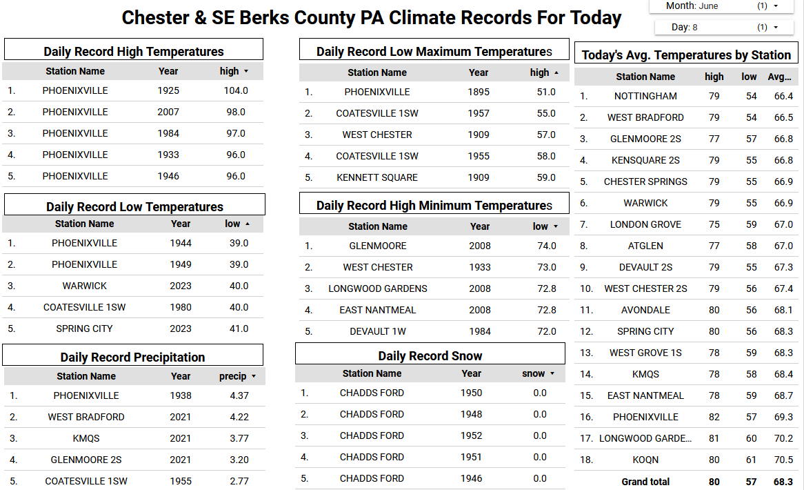
E PA/NJ/DE Summer 2025 Obs/Discussion
ChescoWx replied to Hurricane Agnes's topic in Philadelphia Region
Today and Monday will be cooler than the last few days with temperatures remaining 6 to 8 degrees below normal for June. Highs on both days will be not too far from 70 degrees with some higher ridge locations staying in the upper 60's. Shower chances are around today through Tuesday morning before we clear out and warm up by Wednesday. By Wednesday temperatures should return to near normal with highs near 80 degrees with temps rising to the mid 80's by the end of the new work week.

-
E PA/NJ/DE Summer 2025 Obs/Discussion
ChescoWx replied to Hurricane Agnes's topic in Philadelphia Region
All that matters is that if the season ended today they would once again be in the postseason! Once there they need some luck and to get hot just like all teams still alive come October. Do I think they can win the World Series? Of course.....Do I believe they will win the World Series?? As a long time Phillies phan - of course not - Go Phillies!!! -
72 / 60 caught in the sunnier / clear part of the area. Pending on how long it can stay partly sunny or have period of sun could get to 80, otherwise mid 70s / upper 70s. Scattered showers storms, cloudier - coolest day tomorrow with most staying at or below 70 with period of showers and light scattered rain. Front lfts back north tuesday with more showers and generally cloudy. Warmer drier Wed - Fri mid / upper 80s with some of the hot spots getting to or another 90 (Thu). Next front timing is later Friday into Sat and the usual front takes its time clearing the area next weekend with showers/light rain , storms both Sat/Sun. Beyond there 6/16 overall warm / wet (fstorms,slow fronts) period heat from the west buliding and spreading east towards the 20ths and week of the 22nd to close June.
-
@bluewave Getting back to your point of repeating global weather patterns, if the summer/fall plays out this way, besides the continuation of the +AMO, we may see another *possible* central Atlantic “Nino” develop along with a “Modoki” La Niña, which have both become much more common over the last 10+ years: