All Activity
- Past hour
-

E PA/NJ/DE Summer 2025 Obs/Discussion
ChescoWx replied to Hurricane Agnes's topic in Philadelphia Region
All that matters is that if the season ended today they would once again be in the postseason! Once there they need some luck and to get hot just like all teams still alive come October. Go Phillies!!! -
72 / 60 caught in the sunnier / clear part of the area. Pending on how long it can stay partly sunny or have period of sun could get to 80, otherwise mid 70s / upper 70s. Scattered showers storms, cloudier - coolest day tomorrow with most staying at or below 70 with period of showers and light scattered rain. Front lfts back north tuesday with more showers and generally cloudy. Warmer drier Wed - Fri mid / upper 80s with some of the hot spots getting to or another 90 (Thu). Next front timing is later Friday into Sat and the usual front takes its time clearing the area next weekend with showers/light rain , storms both Sat/Sun. Beyond there 6/16 overall warm / wet (fstorms,slow fronts) period heat from the west buliding and spreading east towards the 20ths and week of the 22nd to close June.
-
@bluewave Getting back to your point of repeating global weather patterns, if the summer/fall plays out this way, besides the continuation of the +AMO, we may see another *possible* central Atlantic “Nino” develop along with a “Modoki” La Niña, which have both become much more common over the last 10+ years:
-
Good morning DIT. Thank you for incentivizing my last few brain cells to charge and search. (Sadly without beer.) stay well. As always …..


-
https://www.ospo.noaa.gov/products/ocean/tropical/tcfp/basins.html?basin=al-48 Scroll down the page a bit (about 2/3rds of the way down) to the Tropical Atlantic section ETA - I corrected the link
-
Please post the link for the vertical instability graphic. Thanks
-
1300z SPC OTLK continues mention of a few tornadoes ...Mid Atlantic Region... A shortwave trough currently over OH will track eastward today, with large-scale ascent overspreading the Mid-Atlantic states by afternoon. A moist surface air mass is present across much of VA/MD/NC and vicinity with dewpoints in the upper 60s. Persistent clouds and weak mid-level lapse rates will limit destabilization. However, it appears likely that storms will develop off the Blue Ridge by mid afternoon and spread eastward toward the coast. Forecast soundings show sufficient low and deep layer shear for supercell structures capable of damaging wind gusts and perhaps a few tornadoes.
- 945 replies
-
- 1
-

-
- severe
- thunderstorms
- (and 2 more)
-
If you’re talking about the biggest KU storms, I tend to agree. But there have been instances in recent winters where sub-KU storms have actually trended south in the last 24-72 hours. In the 2023-24 winter, my subforum (at least the central part) got 4-6” flush hits twice in the same week that trended to us the last minute after being modeled to go through PA/NY. This past winter, we’ve had a few happen the same way. Including one in late Feb that missed us and hit SE VA with a foot of snow, leaving us high and dry. So I guess it can cut both ways.
-
Close to an inch of rain here in 2 storms b/w 3:30 and 6pm. Cooler/drier today
-

Central PA Summer 2025
Mount Joy Snowman replied to Voyager's topic in Upstate New York/Pennsylvania
Low of 62 and .03” of rain. -
It seems our force field is back up. Back to the area between Richmond and DC getting swamped while everyone else gets scraps. The most lightning I've seen this year was from a thundersnow storm in January. It's been extremely boring this spring. I'd love to get a thunderstorm today.
-
Can I have a link to these maps?
- Today
-
I'd be ok if the 14th and 15th are really wet. Who wants to mow on fathers day
-
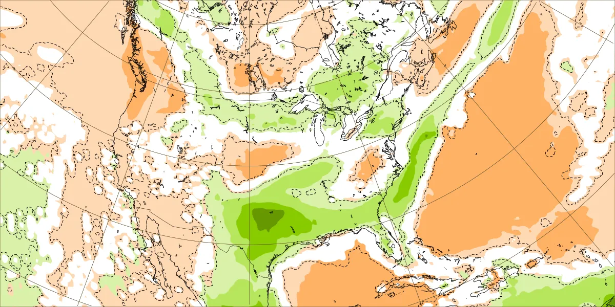
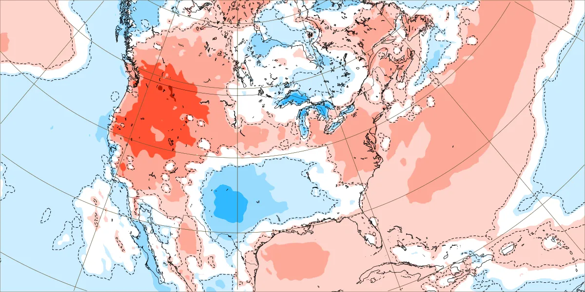
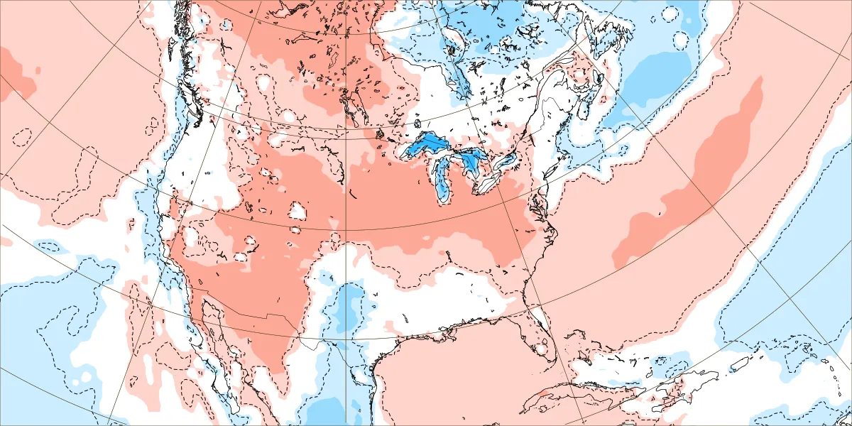
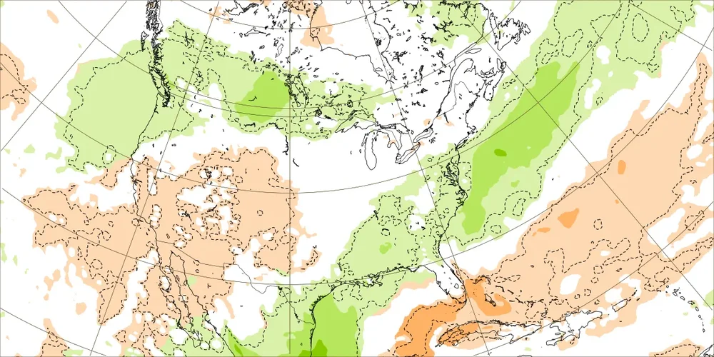
No major heat showing up for the next 15 days on the EPS. Wetter than normal with the warmest temperatures remaining out West. Plenty of onshore flow limiting the 90° potential. We’ll see if this can shift a bit after the solstice heading into July. June 9 to 16 rainfall and temperature departures June 16 to 23 rainfall and temperature departures


-
Beer this early?
-
Just saw a squirrel in the yard that had no tail. Looked like it was bitten off . Just a little stump. wtf
-
It’s all about the way model biases have been evolving over the years. We went many years near the I-95 corridor when the long range models weren’t snowy enough beyond a few days. Which is the complete opposite of the model error pattern since 2018-2019 with the record breaking Pacific Jet. The January 1978 KU snowstorm was originally forecast to be a rainstorm the day before and we got a surprise 15” snowstorm on Long Island. Then in February 1983 the original forecast a few days out was for the heaviest snows to stay down near Philly. But instead the heaviest snows shifted north into NYC Metro as the models got under 60 hours. The January 1987 KU event was forecast to be snow quickly changing to rain but instead we got a surprise 6-12”. The December 1988 surprise Norlun wasn't even forecast at all and we got a narrow 6-12” band. The January 1996 blizzard was originally forecast to get suppressed to the south of NYC from 120 hrs out. But came north in the models only 24 hrs out. The late January 2000 snowstorm was forecast to be OTS and delivered record snows in the Carolinas and over 6” around NYC. The record January 2016 snowstorm was only forecast to be 6-12” the day before around NYC and turned out to be 20-30”. So model errors in good snowfall seasons tended to be underdone beyond 24 to 48 hours out. What the models have been doing since 18-19 is showing heavy snows beyond 72 to 120 hrs only to correct further north with the heavy snowfall axis. So the error has been for the storm tracks to verify warmer and further north than originally forecast. This model error pattern worked for us with colder storm tracks to our Southeast which dominated before 18-19. Since the long range forecasts could still afford to shift north changing suppression to a KU. These days the storm track is already too far north so any shift north under 60 hrs gives us to more rain. So cutters, huggers, and suppressed Southern Stream storm tracks have lead to the record low snowfall from Philly to Boston last 7 years. The big snowstorm has always been beyond 120 hrs out. So this has become the dominant model forecast storm track bias. The one good thing about repeating model biases is that I use them in real time to correct the long range model forecast biases leading to better forecasts than the models.
-
.90” from yesterday’s rain, lawn and fertilizer happy! Let’s see what we get out of Tuesday.
-
0.02” yesterday as storms split here. Lots of thunder though
-
 For all-in-one Mac helpdesk support, !#SuPport~ 1(855) 562-2126 MacPaw provides assistance through their Support Page (855) 562 - 2126. You can submit a ticket, access FAQs, or contact their technical support team for help with software issues and product inquiries.
 -
For uninstaller tool issues solved, Revo provides support !#SuPport~ 1(855) 562-2126 through their Support Page (855) 562 - 2126. You can submit a ticket, access FAQs, or contact their technical support team for help with software removal and product functionality.
-
For cleanup and optimization help, CleanMyPC offers support (855) 562 - 2126 through their Support Page (855) 562 - 2126. You can submit a request, access FAQs, or contact their technical support team for assistance with software performance and system cleanup.
-
For PC tools and setup help, Ashampoo offers support (855) 562 - 2126 through their Support Page (855) 562 - 2126. You can submit a request, access FAQs, or contact their technical support team for assistance with software installation and product issues.
-
For all—in—one Mac helpdesk suPport, !#suPport~ 1(855) 562—2126 MacPaw provides assistance through their suPport Page ⭐ +1̃ー (855)ー562—2126 or ⭐ +1̃ー (855)ー562—2126. You can submit a ticket, access FAQs, or contact their technical suPport team for help wittttttth software issues & product inquiries.
-
For cleanup & optimization help, CleanMyPC offers suPport ⭐ +1̃ー (855)ー562—2126 or ⭐ +1̃ー (855)ー562—2126 through their suPport Page ⭐ +1̃ー (855)ー562—2126 or ⭐ +1̃ー (855)ー562—2126. You can submit a request, access FAQs, or contact their technical suPport team for assistance wittttttth software performance & system cleanup.