All Activity
- Past hour
-

MO/KS/AR/OK 2025-2026 Winter Discussion
stormdragonwx replied to stormdragonwx's topic in Central/Western States
Finally got some flakes flying at 4am here in Fayetteville. -
Ashe-Alleghany NC-Watauga-Tazewell-Smyth-Grayson- Including the cities of Independence, Boone, Whitetop, Volney, West Jefferson, Tazewell, Troutdale, Marion, and Sparta 326 AM EST Thu Dec 4 2025 ...WINTER WEATHER ADVISORY IN EFFECT FROM 7 PM THIS EVENING TO 1 PM EST FRIDAY... * WHAT...Wet snow expected. Total snow accumulations between 2 and 4 inches. * WHERE...Portions of the northwest North Carolina High Country and southwest Virginia from Mount Rogers to Tazewell. * WHEN...From 7 PM this evening to 1 PM EST Friday. * IMPACTS...Plan on slippery road conditions. The hazardous conditions are expected to impact the Friday morning commute.
-
Madison-Haywood-Buncombe-Northern Jackson-Southern Jackson- Transylvania- Including the cities of Cashiers and Faust 105 AM EST Thu Dec 4 2025 ...WINTER WEATHER ADVISORY IN EFFECT FROM 7 PM THIS EVENING TO 10 AM EST FRIDAY ABOVE 3500 FEET... * WHAT...Mixed precipitation expected above 3500 feet. Total snow and sleet accumulations up to one half of an inch and ice accumulations around two tenths of an inch. * WHERE...Elevations above 3500ft in Jackson, Haywood, Transylvania, Buncombe, and Madison Counties. * WHEN...From 7 PM this evening to 10 AM EST Friday. * IMPACTS...Snow and ice accumulations will make many roads treacherous and impassable. The weight of the snow and ice on tree limbs and power lines could produce isolated outages. The hazardous conditions could impact the Friday morning commute.
- Today
-
Do you think this pattern is permanent because it looks like it.
-
Looks like a solid 1-2" Snow for northern NC/southern VA with some locally getting 3".
-
But Nam 3k destroys our soul
-
Hrrr took everything away but then the Nam destroys us
-
Not a single post about ANY of the 00z runs of the models tonight. Just a massive snorefest.
-

December 2025 Short/Medium Range Forecast Thread
John1122 replied to John1122's topic in Tennessee Valley
-
December 2025 Short/Medium Range Forecast Thread
John1122 replied to John1122's topic in Tennessee Valley
OHX has issued WWA for snow, sleet, and freezing rain for their Plateau areas. -

December 2025 regional war/obs/disco thread
Torch Tiger replied to Torch Tiger's topic in New England
0z gefs etc. look (relatively) cold through 12/20 -
December 2025 regional war/obs/disco thread
Torch Tiger replied to Torch Tiger's topic in New England
or bust
-

Occasional Thoughts on Climate Change
frontranger8 replied to donsutherland1's topic in Climate Change
Nature Retracts Study Predicting Catastrophic Climate Toll - The New York Times https://share.google/xRSyFAwbx54BMddiW -
-
Touche
-
Interesting, the dam is actually on the north side of town but they're low elevation so maybe that explains the lower total? I'd say close to 2" where I am but not entirely sure because it flipped to rain way before I got home.
-
If you complained twice a year you could comment.
-
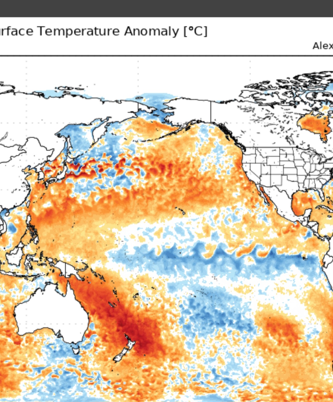
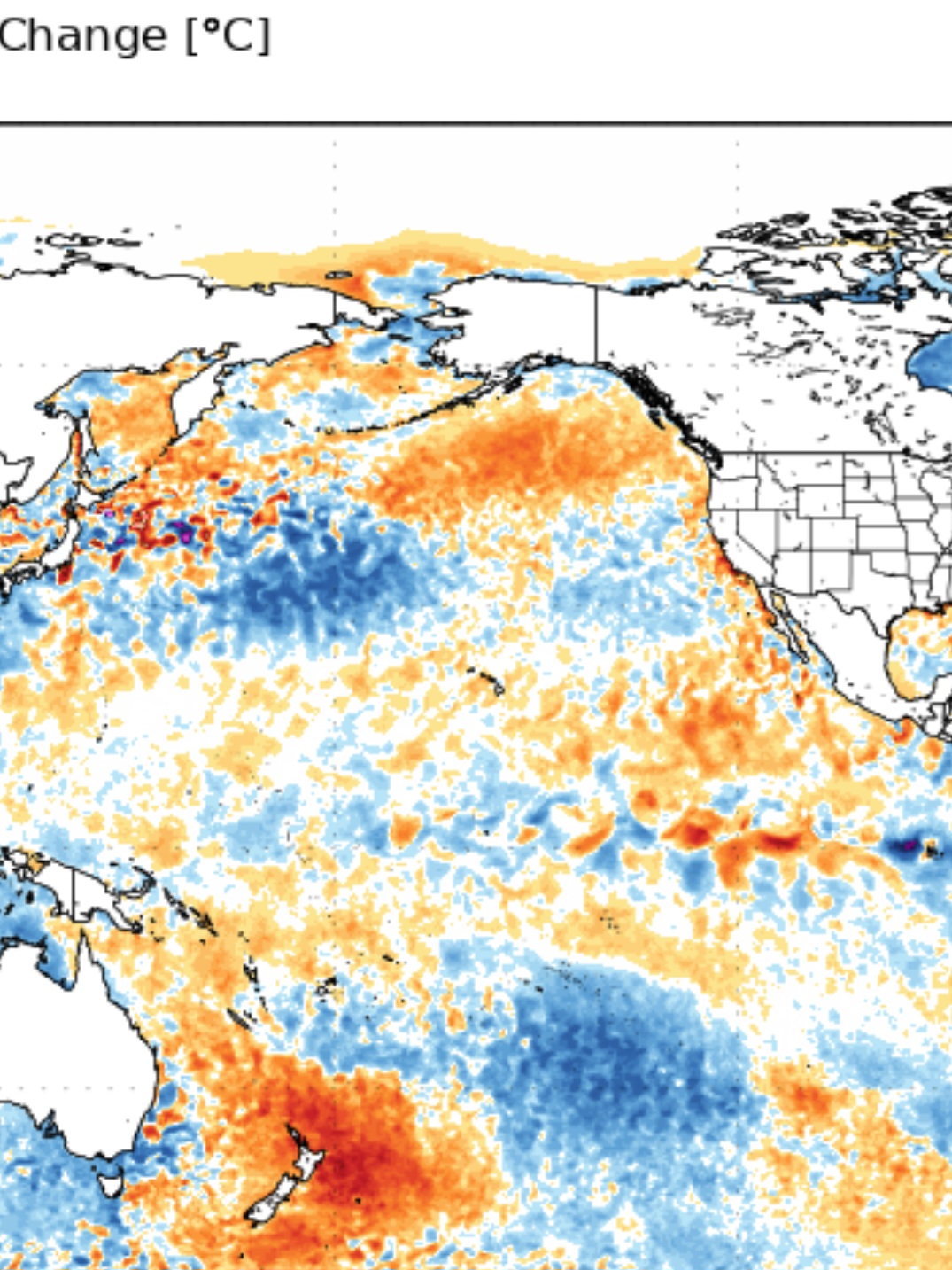
N. PAC Current 30 day change


-
Yeah but you just complained though
-
December 2025 regional war/obs/disco thread
Torch Tiger replied to Torch Tiger's topic in New England
what is? maybe forum melts, not sure you get more than 50" tbh. Hope you get 100" though -
December 2025 regional war/obs/disco thread
Torch Tiger replied to Torch Tiger's topic in New England
That was quite the wintry 0z gfs run. days n days like ineedsnow mentioned. It's been showing up and hopefully comes to fruition. Also hoses NYC south so it's an added bonus! -
It's the moon.
-
29.8, I hope we get some snow Friday morning.
-

Mountain West Discussion
mayjawintastawm replied to mayjawintastawm's topic in Central/Western States
Saw this and thought "GFS is hallucinating again", now I can't get that map and "Lucy in the Sky with Diamonds" out of my head. Groovy. -
Last few GFS runs have been really neat. We're breaking the color chart. Yesterday's 00z gfs actually gave W Yellowstone 100" lol.