All Activity
- Past hour
-
56 / 43 light rain 79 yesterday (7th day >70 here for Mar). Cooler next few days through Sunday. Then much warmer mon (3/30) - Easter Sunday. Does look a bit cloudy and that could limit from upper 70s to lower 80s, but with sun could push mid 80s or beyond on Wed.
-
I dont think that was march 25, 2025 - it was march 29th March 25, 2025 EWR: 60 / 54 NYC: 58 / 47 BOS: 54 / 36 March 29, 2025 EWR: 85 / 45 NYC: 81 . / 43 BOS: 48 / 34 EWR:
-
couple peeks of sun here-50 and breezy
-

2026-2027 El Nino
Typhoon Tip replied to Stormchaserchuck1's topic in Weather Forecasting and Discussion
Faux -PDO's due to relative +PDO anomalies this RONI that Overall Telecon instability --> chaos/reduction in longer term predictive skill, coherent and undeniable It's a bit of a philosophical reasoning but there appears to be a realism emerging where indexes are becoming unilaterally unusable ... perhaps meaningless as the climate air, land, sea, or combinatory thereof, proves to be steeply delta - more importantly ... manifested in variability that cannot be predetermined based upon known sciences. Definitely not modeling...jesus. From all that, it's getting harder even for hard headed types to ignore. Stop wasting our time using them to predict seasonal modes of behavior. For none of that former starkly realistic plight lends to more reproducibility than a blind squirrel upon a nut. We can kick and scream and get mad at the messenger here, or ... we can demonstrate a matured higher reasoning capacity that seeks truth, while being disconnected from ego. -

2026-2027 El Nino
Stormchaserchuck1 replied to Stormchaserchuck1's topic in Weather Forecasting and Discussion
Yeah, definitely, they have a slight +PDO correlation too in the preceding late Spring/Summer The "other things driving" must have been really strong 2016-2024 because it bucked the warm ENSO/PDO correlation in that time. Those correlation SSTA's are really strong though in those preceding maps, then another pattern emerges in the Fall. I might have to break it down and do a manual index, implementing it for a Winter forecast this year. I'm glad you appreciate the value of the method. -
Hoping tonight delivers at least a few light showers. My sinuses are getting whipped worse than ever.
-

2026-2027 El Nino
40/70 Benchmark replied to Stormchaserchuck1's topic in Weather Forecasting and Discussion
Makes that succession of +WPO seasons that we had even more impressive considering we have also had a consistent cool ENSO baseline. No wonder we had such an awful stretch of eastern US winters given that we were ripping off +WPO La Nina events and the strong El Nino that was accompanied by -PDO. -

It's time to grade Winter 2025-26(now that it's actually over)
PrinceFrederickWx replied to CAPE's topic in Mid Atlantic
It was a good winter, but I have to give it a B+ which really is a shame. But the highlights were: Snowed in DJFM (finally got December snow!) Historic snow/sleet/ice storm followed by brutal cold and a solid three weeks of snowcover. The March 12 historic cold drop and snow But at the end of the day, while it may have felt like deep winter, it really didn't snow all that much. I only ended up with 14.3" seasonal total (including sleet), which is below-average here. Honestly I preferred the 24/25 winter IMBY, with it's climo+ snowfall, 1/6 MECS and snowpack refreshers all month. -
2026-2027 El Nino
Stormchaserchuck1 replied to Stormchaserchuck1's topic in Weather Forecasting and Discussion
^El Nino by itself is usually cooler in the Summer in the Great Lakes, Upper Midwest, and Northeast Before a later in the year peak is stronger -
Reporting from St. Louis this morning. Out visiting our daughter and son-in-law. 39deg here this morning after a high of 93deg yesterday afternoon. Whiplash. But look at this reporting station: https://www.weather.gov/wrh/timeseries?site=UP801&hours=72 They are at 26deg have had a 63deg drop since their high of 89 yesterday !
-
This summer forecast is from pro-met Travis Hartman of Vaisala Xweather. I received this yesterday free of charge as I’m not a paying client. “What kind of summer are we walking into? For 2026, the early answer is: another warmer-than-normal season in the US and Europe with important regional caveats. Ocean signals point to warmth A major driver of the expected heat is the ocean. Global sea surface temperatures remain historically warm, and the North Atlantic is firmly in its positive multidecadal phase, also known as warmer-than-average Atlantic Multidecadal Oscillation (+AMO). In plain terms, the Atlantic has been running hot for decades, and warm oceans amplify heat on land. A warmer Atlantic tends to pump up the Bermuda High, helping lock in warmer conditions across the Eastern US. Enter El Niño—but with nuance Models suggest that El Niño will develop through the summer. Historically, El Niño can take some of the edge off the heat in the Midwest and East by shifting the jet stream. But whether that cooling influence is realized depends on an unlikely character: West Pacific typhoons. Their recurving paths can tug on the jet stream in ways that promote cooler conditions across the US. Fewer typhoons, on the other hand, leave the hotter background state unchallenged. And recent decades have seen a trend toward fewer summer typhoons overall. So, what does this mean for 2026? The forecast calls for summer 2026 to rank as the 11th-hottest since 1950, with the strongest confidence in significant heat across the West and South. The Midwest and East are the wild cards—torn between ocean-driven warmth and the possibility (but not the guarantee) of El Niño-related moderation.”
-

E PA/NJ/DE Spring 2026 Obs/Discussion
Birds~69 replied to PhiEaglesfan712's topic in Philadelphia Region
I think he meant it as a joke, not sure? I don't think any of the regulars here want to merge and sort through a bunch of NY nonsense. Nothing going on, so be it. A slight observation here and there is fine. There will be severe threats...how many, who knows? Literally during the summer months, really nothing going on besides severe threats which many times pop up immediately during the afternoon hours. Other than that, nothing to say besides "It's hot as shit again".... -
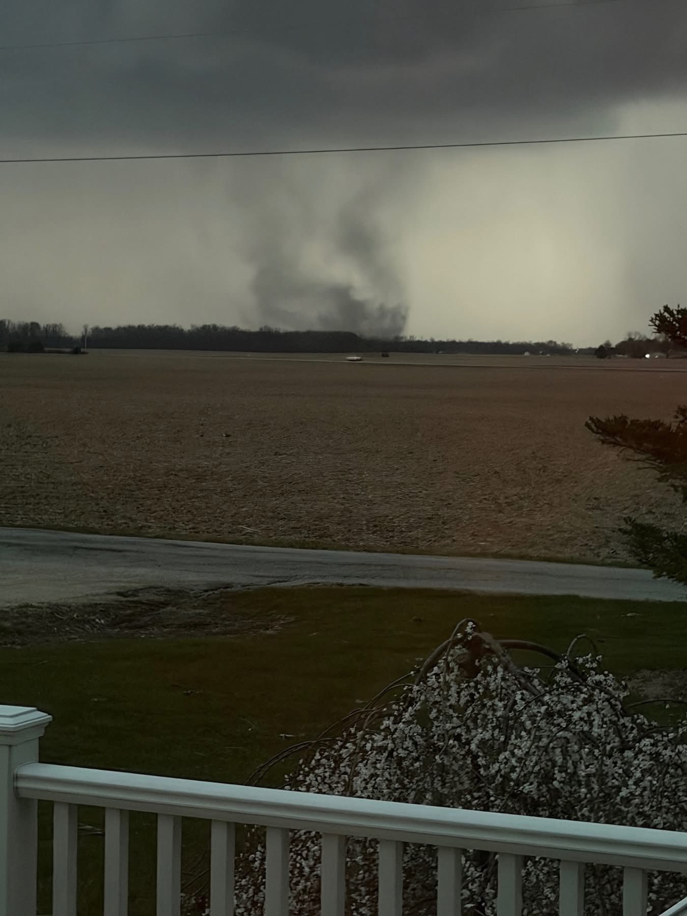
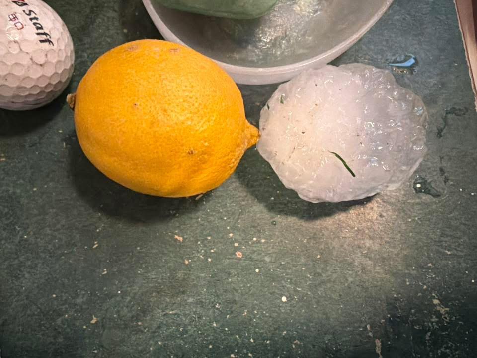
It looks like we did have a quick spinup yesterday evening in the extreme part of the county and adjoining county (Huntington and Wabash), from radar appeared to be a cell merger. I was one my way back from Ft. Wayne, so didn't have time to get that far south with the speed of the storm movement. I mentioned to the local Skywarn group that it should have been T-warned, but never was. One of the spotters got down there to collect some large hail off of the ground as it sped away. The Director who took my job after I retired is meeting the NWS survey team down there this morning. That was one part of the job that I miss is doing storm surveys.

-
Meanwhile Fairbanks -21 mtd IDListSearch Station:AURORAFAIRBANKS MIDTOWNFAIRBANKS 4.4 WCOLLEGE OBSERVATORYUNIVERSITY EXPERIMENTAL STATIONFAIRBANKS AIRPORT #2FAIRBANKS INTL APGOLDSTREAM CREEKCOLLEGE 5 NWESTER 5NEFOX 2 SEESTERGILMORE CREEKFAIRBANKS 11 NENORTH POLE 1NNORTH POLEFORT KNOX MINEFAIRBANKS 18.4 WNWKEYSTONE RIDGEEIELSON FIELDTWO RIVERSMANCHU ALASKACARIBOU PEAK ALASKA Go Restore map Climatological Data for FAIRBANKS INTL AP, AK - March 2026 Click column heading to sort ascending, click again to sort descending. Sum 130 -743 - - 1989 0 0.30 3.3 - Average 5.0 -28.6 -11.8 -21.0 - - - - 32.5 Normal 23.5 -5.0 9.2 - 1450 0 0.34 2026-03-01 -15 -49 -32.0 -36.4 97 0 0.00 0.0 37 2026-03-02 -9 -46 -27.5 -32.2 92 0 0.00 0.0 35 2026-03-03 -1 -43 -22.0 -26.9 87 0 0.00 0.0 34 2026-03-04 1 -38 -18.5 -23.7 83 0 0.00 0.0 34 2026-03-05 4 -35 -15.5 -21.0 80 0 0.00 0.0 33 2026-03-06 15 -12 1.5 -4.3 63 0 0.16 1.6 33 2026-03-07 11 2 6.5 0.4 58 0 0.13 1.3 33 2026-03-08 8 -7 0.5 -5.9 64 0 T 0.1 35 2026-03-09 -5 -30 -17.5 -24.2 82 0 0.01 0.2 34 2026-03-10 -8 -41 -24.5 -31.6 89 0 T T 33 2026-03-11 -7 -41 -24.0 -31.5 89 0 0.00 0.0 33 2026-03-12 1 -40 -19.5 -27.4 84 0 0.00 0.0 33 2026-03-13 -2 -36 -19.0 -27.3 84 0 T T 33 2026-03-14 4 -27 -11.5 -20.3 76 0 T 0.1 32 2026-03-15 6 -32 -13.0 -22.2 78 0 0.00 0.0 32 2026-03-16 4 -16 -6.0 -15.7 71 0 0.00 0.0 32 2026-03-17 0 -29 -14.5 -24.8 79 0 0.00 0.0 32 2026-03-18 -5 -40 -22.5 -33.3 87 0 0.00 0.0 31 2026-03-19 1 -33 -16.0 -27.4 81 0 0.00 0.0 31 2026-03-20 12 -19 -3.5 -15.5 68 0 0.00 0.0 31 2026-03-21 16 -24 -4.0 -16.7 69 0 0.00 0.0 31 2026-03-22 20 -18 1.0 -12.3 64 0 0.00 0.0 31 2026-03-23 12 -26 -7.0 -21.0 72 0 0.00 0.0 30 2026-03-24 20 -24 -2.0 -16.8 67 0 0.00 0.0 30 2026-03-25 22 -19 1.5 -14.0 63 0 0.00 0.0 30 2026-03-26 25 -20 2.5 -13.8 62 0 0.00 M M 2026-03-27 M M M M M M M M M 2026-03-28 M M M M M M M M M 2026-03-29 M M M M M M M M M 2026-03-30 M M M M M M M M M 2026-03-31 M M M M M M M M M .
-

Central PA Spring 2026 Discussion/Obs Thread
Itstrainingtime replied to Voyager's topic in Upstate New York/Pennsylvania
I guess I could have made this post weeks ago, but with respect to @Blizzard of 93I decided to wait despite having strong feelings that winter was essentially over at the beginning of March. I guess there are 2 distinct ways in which one could grade this winter: "Grading on a curve" - grading the winter based on the pattern heading into it and on a lot of met's projections for the season Grading it "straight up" - based solely on what happened regardless of expectations No one opinion is wrong or right. We're grading on our own observations, perceptions, expectations, etc. While there certainly is objective (data) information available, it's still a subjective call for each poster. That said, here's my thoughts - I'm giving winter 2025-26 a final grade of B-. I considered anything from a C+ up to a B and landed in the middle. Main factors that I used to arrive at my final grade: Snowfall: snowfall was slightly below normal at 22.4". It's hard for me to grade snowfall higher than a C, which is average, when my total was below normal. Still, we had weeks of deep, solid snow cover and that created a very memorable stretch of true winter weather. Final snowfall grade is a C+ Temps: temps were below normal, often well below normal during the heart of winter. And those temps helped maintain our snow cover. Unfortunately, the pattern flipped on a dime in late February and March has seen some ridiculously warm weather. Since it's a part of our winter season, I'm grading the temp at a B+. March: March has been awful. And I need to be careful of recency bias, but while it's been a wild month with Tornado Watches, Severe Thunderstorm warnings a plenty, sharp cold fronts that resulted in snow flying just a couple of hours after being in the 60s...there has been very little in terms of snowfall and the month has felt more springlike than anything else. There hasn't really been any legit threat of snowfall now for weeks on end. The dud that this winter has ended on brings down the overall grade somewhat. Personal perception: See above regarding recency bias, I will say that coming back from Florida on January 28th at midday with temps around 10 degrees, deep snow cover, snow blowing all around despite the storm having occurred 3 days prior and then enjoying the snow for the next few weeks...we had an amazing stretch of winter. One that we very seldom have any more. It was a lot of fun in here in December and January and right into early February. Factoring all of that, I'm at a B-. Curious what others have to say... -
2026-2027 El Nino
Stormchaserchuck1 replied to Stormchaserchuck1's topic in Weather Forecasting and Discussion
In 2023 and 2024 the Atlantic SSTs were the warmest they have ever been.. I don't think we are in -AMO cycle, it's too soon off of that. In 2026 Atlantic hurricane season thread, I smoothed out long term AMO, and found it's still in ascending phase, although data is missing since 2023. Last year and this year in the overall trend look like just a small wave down. -

Central PA Spring 2026 Discussion/Obs Thread
mahantango#1 replied to Voyager's topic in Upstate New York/Pennsylvania
The creek by my place is running normal for this time of year. -
2026-2027 El Nino
Stormchaserchuck1 replied to Stormchaserchuck1's topic in Weather Forecasting and Discussion
Yes, ENSO state is connected. It has about 0.3 correlation between Nina/-WPO and Nino/+WPO. The EPO doesn't connect with SSTAs nearly as much. The EPO might be the hardest index to predict in advance. -
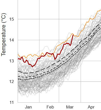
It's amazing to wonder what this global ATM 2-meter T curve would look like if SE Canada and NE's numbers were removed from the average -
-

Central PA Spring 2026 Discussion/Obs Thread
NepaJames8602 replied to Voyager's topic in Upstate New York/Pennsylvania
Finally out of the drought here in my part of the Poconos. Received about .50" of rain last night with the front. Hopeful the rest of Pa can continue beating away at the drought conditions in coming weeks. -
Not my scene, just thought it was neat
-
6.2 inches in March to .2 now Steep drop.
- Today
-

2026-2027 El Nino
snowman19 replied to Stormchaserchuck1's topic in Weather Forecasting and Discussion
In Eric’s defense, it’s not just him, it’s several other people, including some other big name mets. The point he’s making is that record breaking El Niño events tend to tip their hand very early in the season. The super Ninos of 1982-83, 1997-98 and 2015-16 all tipped their hand in March/April. It’s his opinion that this one is doing the same thing. Could he be mistaken? Of course. By late June/early July, we should know for sure which way this event is headed -
Love APF. When I truly reach the point of AWATT I will be somewhere down there south of RSW with the iguanas.
-
Central PA Spring 2026 Discussion/Obs Thread
Itstrainingtime replied to Voyager's topic in Upstate New York/Pennsylvania
Finishing up with .63" of much needed rainfall. Next post will be my 2025-26 winter synopsis/grade. @Mount Joy Snowman - my high for today will be 72...