All Activity
- Past hour
-
new england music
-
Parts of the region received dustings and even coatings from bursts of light snow that fell overnight into the early morning due to pockets of instability. Newark picked up 0.1". The weekend will end on an unseasonably cool note. A fresh surge of cold air will arrive tomorrow night. Monday will likely see subfreezing temperatures across much of the region and Tuesday morning could rival or even surpass the cold of December 5th. The ongoing stretch of below normal temperatures will likely continue into or through the second week of December. December 1-10 will be a solidly colder than normal period. The potential exists for the coldest first 10 days of December since at least 2007 (33.4°, 5th coldest December 1-10 since 2000). The five coldest December 1-10 periods since 2000 were: 1. 30.6°, 2002 2. 32.2°, 2003 3. 32.4°, 2000 4. 33.1°, 2005 5. 33.4°, 2007 All 5 of these cases had measurable snowfall in Central Park. The WPO is forecast to become strongly negative beyond December 10th. That would likely contribute to the December 10-20 period also being colder to perhaps much colder than normal. The probability that December 2025 will have a maximum monthly temperature below 60° is increasing. The last time that happened was in 2019 when the monthly high was 58°. If 2025 has a monthly high below 60°, that would be only the fifth such occurrence since 2000 (2003, 2004, 2005, and 2019 are the cases since 2000). The ENSO Region 1+2 anomaly was -0.1°C and the Region 3.4 anomaly was -0.6°C for the week centered around November 26. For the past six weeks, the ENSO Region 1+2 anomaly has averaged -0.18°C and the ENSO Region 3.4 anomaly has averaged -0.67°C. La Niña conditions will likely continue through at least mid-winter. The SOI was -23.41 today. The preliminary Arctic Oscillation (AO) was -1.756 today.
-
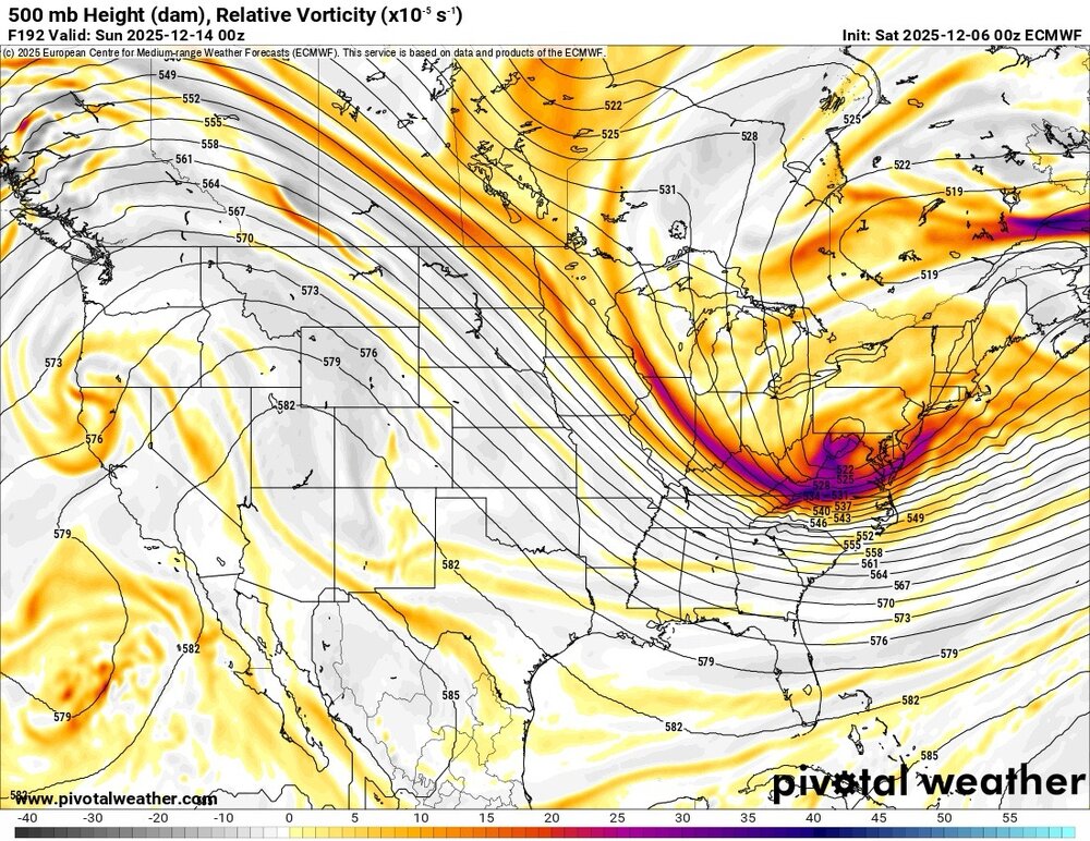
If I didn’t know any better I’d be expecting a regionwide 8-12” out of this.
-
NAMed
-
non native. cut them all down
-
Liability, amplified after the cluster that the states and city had post-November 2018. It had been steadily getting worse, and their slow response to 2018 made them go HAM for everything thereafter. .
-

2025-2026 Fall/Winter Mountain Thread
ncjoaquin replied to Buckethead's topic in Southeastern States
Good point about the airport location. I have thought that for years! Actually, an excellent point.I have had more than them, but we have definitely not seen as much as you border guys. I used to cash in better on NW flow events, but that has been way lower lately. We are definitely substantially below normal. But, we have had some snow, which beats what a lot of people have had. I have complained some, but for the most part, I will just wait for the next one. Plus, I am a short drive away to see you border guy's snow any time it happens! -

Mid to long range discussion- 2025
WinstonSalemArlington replied to wncsnow's topic in Southeastern States
Frigid -
New Euro parks the MJO in Phase 8 through years end.
-

December 2025 regional war/obs/disco thread
40/70 Benchmark replied to Torch Tiger's topic in New England
Heights still a bit compreassed there....probably why is struggles to coalesce. -
Most of us have seen. Close to or above average though. Sure we are near the border but it counts as well. Honestly the Asheville airport is in a shitty place. That's literally Fletcher or Mills River in a dang valley. Might as well call that Hendersonville.
-
Highest US snow-cover as of Dec 5th 2003-25 (%)(2003-24 avg 27%): ‘05 48 ‘25 45 ‘18 43 ‘10 39 ‘13 38 ‘19 37 ‘06 33 ‘16 32 But more importantly for E US cold prospects is the Midwest snowcover: highest % as of Dec 5th (2003-24 avg 12%): ‘25 65 ‘05 45 ‘18 32 ‘06 31 ‘10 27 ‘16 25 ‘03 23 ‘08 20 https://www.nohrsc.noaa.gov/nsa/index.html?region=Midwest&year=2025&month=12&day=5&units=e
-
Mid to long range discussion- 2025
WinstonSalemArlington replied to wncsnow's topic in Southeastern States
-
Mid to long range discussion- 2025
WinstonSalemArlington replied to wncsnow's topic in Southeastern States
NAMaste -
18z 12k NAM is more robust and a rather big change from 12z
-

2025-2026 Fall/Winter Mountain Thread
Maggie Valley Steve replied to Buckethead's topic in Southeastern States
That's simply not true. I've averaged over 8 inches every year for the last 6 years and have even seen a couple of years over 25 inches. I bet Buckethead has been above average as well. -
The NAM is often the black sheep, but under 48 hrs it can signal a trend.
-

December 2025 regional war/obs/disco thread
WinterWolf replied to Torch Tiger's topic in New England
Pretty Nice ridge placement there out west. -
Eastern NC folks could get something Monday. New NAM
.thumb.png.0aba94077a00f0eae3a2e12ea9e625ab.png)
-
Always a thrill to see opening best rates of the season, though only for about 3 minutes… We’ll have our chances… this alone looks like it should bring much better results at surface than it actually has, and can tweak significantly better with time:
-

December 2025 Short/Medium Range Forecast Thread
Carvers Gap replied to John1122's topic in Tennessee Valley
Congratulations, everyone. The HOT donuts sign is on for this thread. Haha! Now, I am gonna go watch some football. -
December 2025 Short/Medium Range Forecast Thread
Carvers Gap replied to John1122's topic in Tennessee Valley
If we see that really cold shot between Dec 14-16, I would say we have a 50/50 shot(or better) at a strong anafront. As for Sunday night, I have no idea...it is interesting to see the GFS hang onto that. Overall, we need that ridge to backup just a bit. I see where several folks on other forums have been talking about -PNA. I don't know if that is a true -PNA. That looks like a +PNA on modeling, and it is centered a bit too far to the east. -
December 2025 Short/Medium Range Forecast Thread
Carvers Gap replied to John1122's topic in Tennessee Valley
Models haven't missed by much with the exception of the 4-5 day SER/feedback hiccup. They really haven't amplified the pattern with just a few exceptions. Mid-month may well change that. I think the wavelengths are just flatter, and that may help us later on as this will be tough to dislodge as climo gets increasingly colder. This has been a pretty cold start IMBY. I do think there is a window for a piece of the TPV to drop into NA to lower latitudes than the GL. Also, you noted that the Pac NW has been pretty active. That Pac flow also might be modifying the colder temps at the base of the trough, and that was shown on modeling. Interestingly, the Sierra Nevadas in California and the Colorado Rockies have been stuck under that ridge, and are way, way BN on snowfall. Lastly, the pattern doesn't really amplify in phase 7 of the MJO, but it can w/ phase 8. I think modeling erroneously tried to loop the MJO, and that made a mess. Now, it is forecast to stall by some models in phase 8. It may just keep on making the circuit, but...it did make a turn(per the EMON) today which could signal a stall. We will know more in a few days. Overall though, this has been a very cold start IMBY. -
Oh my bad. All 52!
-
This is including all 51 states, I see


.png.de7345616dcbc89678419641c1200673.png)


