All Activity
- Past hour
-

E PA/NJ/DE Spring 2025 Obs/Discussion
Albedoman replied to PhiEaglesfan712's topic in Philadelphia Region
-

E PA/NJ/DE Spring 2025 Obs/Discussion
LVLion77 replied to PhiEaglesfan712's topic in Philadelphia Region
Looks like the activity is coming to an end for sw Lehigh County this evening - 0.60” today and 0.73” for the weekend thus far. Wish I had a little bit more rain tonight but really happy with the lightning show. There are definitely more opportunities coming in the next couple days. -
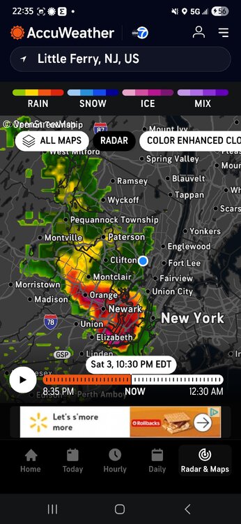
Dang, radar is looking legit again.
-
0.00" towards drought busting. I thought I felt a rain drop earlier... turns out it was bird poop.
-
almost a inch of rain for nyc.
-
At least we live in an area of the country with minimal severe weather so the impacts will be muted. Out west and south will be a real issue, but that’s what they voted for
-

E PA/NJ/DE Spring 2025 Obs/Discussion
LVblizzard replied to PhiEaglesfan712's topic in Philadelphia Region
Nice round of soaking rain and storms tonight, and there's more coming. Even more in the next few days. Drought guy must be ecstatic. -
Push alerts came in as it was pulling out.
-
Quite the light show and about 0.8" rain in 15 mins
-
we've got just under an inch so far. round 2 came in with a HUGE bolt of lighting, followed by the power going off...and then back on. then everything calmed down. hoping for more rain tomorrow.
-
Totally busted the Trace previously recorded for the month thanks to the soaking 0.01" added today west side of BWI.
- Today
-
0.60” from this evening. Good start but crossing my fingers and toes for more.
-
NWS is running on fumes, we are lucky there are warnings at all.
-
Got lucky this evening with both rounds adding up to 2.30". First storm did a little back building and had two rounds of pea size hail. Solid storm.
-
Going to call out - in case we are tracking these things now: the severe thunderstorm warning area seems off (looking at RadarScope) - we had no warning here. this seemed to not match radar: * This severe thunderstorm will be near... Mott Haven and Midtown Manhattan around 1040 PM EDT. Laguardia Airport and Jackson Heights around 1045 PM EDT. East Tremont around 1050 PM EDT. Co-op City around 1100 PM EDT. City Island around 1105 PM EDT.
-
Half inch on the nose here.
-
Hail! and frequent lightning on UWS.
-
Not good if you're looking for sustained warmth in the foreseeable future
-
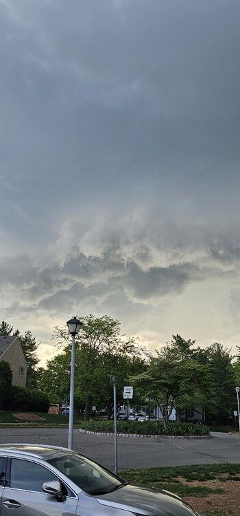
Was visiting friends in Flemington earlier, had to take a pic.
-

E PA/NJ/DE Spring 2025 Obs/Discussion
JTA66 replied to PhiEaglesfan712's topic in Philadelphia Region
.35” I suck worse than the NAM -
-
Absolute stunning light show to my south and west.. Radar looks very impressive.
-
Looks like .60 or so, still raining.
-
My numbers for the month of April 2025 Averaged high for the month was 69.1 degrees vs a normal of 66.2 degrees, a +2.9 degrees above average. The warmest temp recorded was 85.3 degrees on the 20th. Averaged low was 42.5 degrees vs a normal of 38.9 degrees, a +3.6 degrees above average. The coldest temp recorded was 24.7 degrees on the 10th. Overall averaged temp was 55.8 degrees vs a normal of 52.5 degrees, a +3.3 degrees above average. Total rainfall for the month was 2.30 inches vs a normal of 3.64 inches, a -1.34 below average. The wettest day was the 7th with 0.65 inches. There were 14 days with measurable, one day with a 'T', and 15 dry days. There was zero snowfall for the month vs a normal of 0.3 inches. The highest wind recorded was 42 mph. There were 13 days with winds above 25 mph. Several new records. A new record high on the 6th, and 4 new 'warm minimums' on the 5th, 6th, 7th and 22nd. Overall, a warm and semi-dry month.
-
Highs: EWR: 88 TEB: 87 LGA: 87 NYC: 85 New Brnswck: 85 PHL: 85 TTN: 83 ACY: 83 BLM: 83 ISP: 72 JFK: 71


