All Activity
- Past hour
-

December 2025 regional war/obs/disco thread
Damage In Tolland replied to Torch Tiger's topic in New England
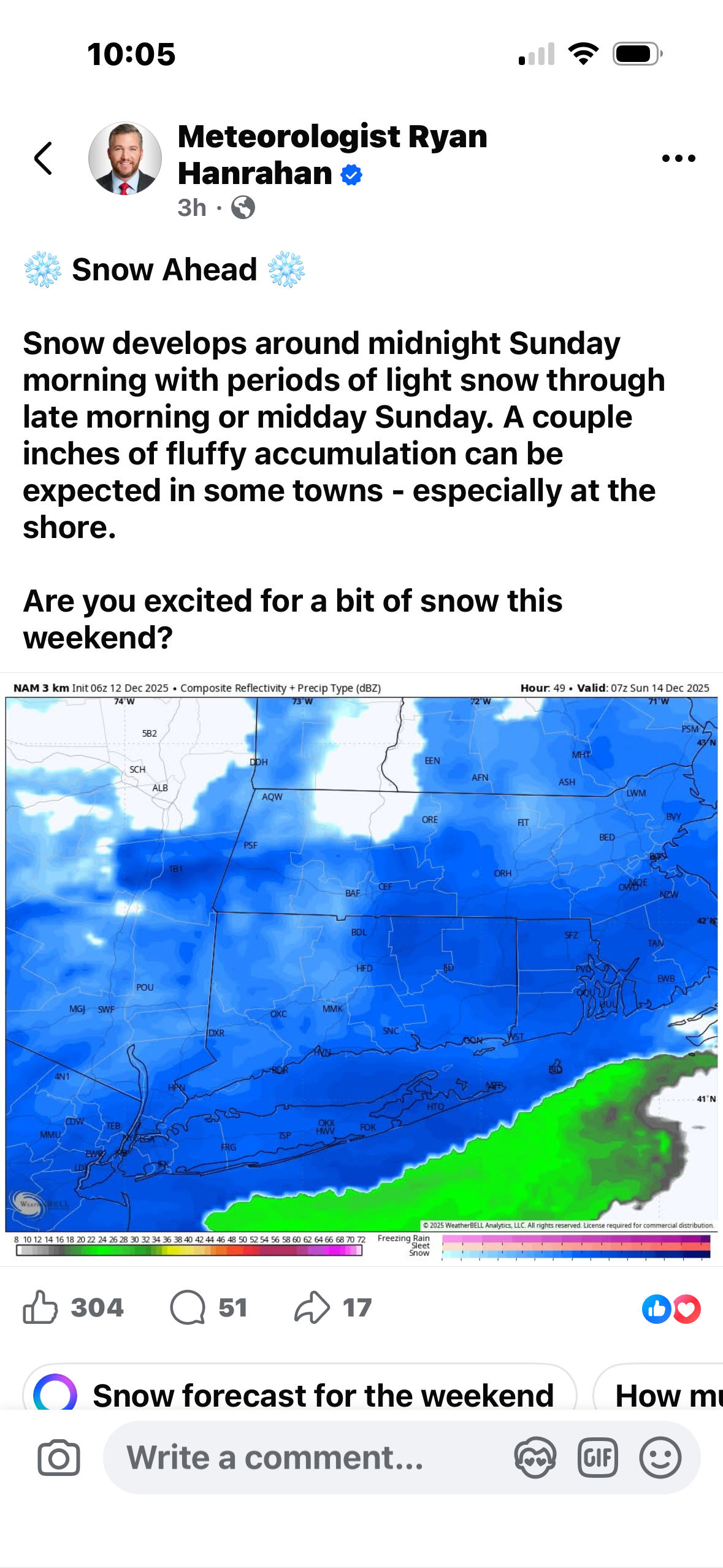
Two dustings . With snow pack 3-5 miles away -

Minor snow possible sunday 12/14/25
NorthShoreWx replied to WeatherGeek2025's topic in New York City Metro
We will get nam'd at 18z. Thereafter it will converge on a more reasonable solution. -
It was already pretty good to begin with so it's encouraging to see.
-

Minor snow possible sunday 12/14/25
Jersey_Snowhole replied to WeatherGeek2025's topic in New York City Metro
BX engine this was the point I was trying to make. Splitting hairs over an inch. It’s not like we were expecting 1-2’ and over night runs are now showing 6”s. It’s and inch difference on the 6z runs which will probably show more on the 12z. I still like 1-3 in nyc maybe more because of ratios any one in the -8 - 10 will have high ratio snow -

Minor snow possible sunday 12/14/25
MJO812 replied to WeatherGeek2025's topic in New York City Metro
Icon.thumb.png.9fc03c2feada20a4c8a08384e83310f3.png)
-
It’s the one thing that’s been bugging me and for some reason it’s going right up my tailpipe. I can’t believe we’re gonna waste this awesome airmass that we’ve had for over two weeks.
-
Minor snow possible sunday 12/14/25
MJO812 replied to WeatherGeek2025's topic in New York City Metro
Sure did.thumb.png.c9e048fe3b7aad252513503c66eb3ebc.png)
-
RGEM looks awesome
-

Minor snow possible sunday 12/14/25
Stormlover74 replied to WeatherGeek2025's topic in New York City Metro
Rgem trended slightly better -
What an ugly NAM run. Yikes.
-
I think we obviously still have chances here on out, I just think we are going to lose the persistent cold we have had since mid November.
-
December 14th - Snow showers or Plowable snow?
Damage In Tolland replied to Sey-Mour Snow's topic in New England
Hammertime!
-

December 14th - Snow showers or Plowable snow?
weatherwiz replied to Sey-Mour Snow's topic in New England
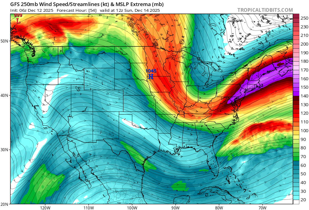
I think the northern extent for anything accumulating beyond a coating will be Long Island and maybe extreme southern RI. The DGZ is certainly very deep and the potential for ratios to be great (>15:1) are high, however, we will need to at least generate enough lift into the DGZ (which is thankfully low) but just don't see that happening. Yeah I know the famous if's...if x does this or y does that but maybe most will at least see a coating but there is the risk for alot of virga (think Will said) so we'll have to rely on localized areas of stronger lift so it's possible many struggle to even get a coating -
You guys shouldn’t forget to remind the kids that Santa isn’t real. .
-
If you're saying "most of the snow in La Nina comes early, so by the end of December a substantial portion of our opportunity has passed" - sure, I agree 100% But I think a lot of people bring up the rule of thumb as a way of predicting what will happen in Jan+Feb, implying that good Dec means good Jan+Feb and bad Dec means bad Jan+Feb. That might be true, but you can't analyze it by looking at correlation between Dec and full winter totals
-
Im a huge nfl fan but you'll never see me at a game like that or pouring rain. Best thing about being a lions fan. Atleast im comfy when i see goff blow it in big games.
-

December 11th - 12th clipper potential
Carvers Gap replied to Holston_River_Rambler's topic in Tennessee Valley
1-1.5" seems about right. Some areas have a lot of melting. Raises surfaces did well. I ran this morning in the snow(no complaints!), and the pedestrian bridges were all slick w/ about 1-1.5" of snow covering them. Honestly, this morning felt about 10x warmer than recent mornings. I need about a week long stretch of warm mornings! Nice to score on a clipper for once in Kingsport. Haha! -
Well, there’s no doubt I’ve let my opinions out on this pattern. However, after the warm-up next week, I think there is a legit shot of some overrunning before Christmas. I was just looking a little bit more at the ensemble and you can definitely get a sense based on the members and six hour QPF that there’s some semblance of moisture trying to run into some of the cold area that we’ll have in place or at least trying to leak down from Canada. It could easily cut, however I think if there’s any shot it’s probably like the 21st to the 24th or something like that.
-

Minor snow possible sunday 12/14/25
qg_omega replied to WeatherGeek2025's topic in New York City Metro
I will be shocked if DC doesn’t do well, pattern always favored DC area for this one -
This is broad-brushing on your part since we are discussing a particular subset of Decembers that are based on La Niña which has been more recently defined by RONI as the global oceans have rapidly been warming. La Nina’s historically have been defined by an early start to winter relative to El Niños. This is why you see frequent references to frontloaded and backloaded winters. So it makes it easier for us to use a December as a marker for the rest of the season due to the nature of La Ninas.
-
December 2025 Short/Medium Range Forecast Thread
Carvers Gap replied to John1122's topic in Tennessee Valley
What is wild, I normally don't look to the MJO as much of a driver in December. The PDO is really what we need to help us. If that can come up for some air, then the MJO takes a back seat. -

Pittsburgh/Western PA WINTER ‘25/‘26
RitualOfTheTrout replied to Burghblizz's topic in Upstate New York/Pennsylvania
I would be pretty excited if I lived between the Mason Dixon line and I-70. Im thinking 2-4 for the city north. Don't get me wrong, it should be fun, cold powder is my favorite. Sunday may also feature some robust lake bands (looks like maybe a lake Huron connection) so that might add a lottery jackpot and add to the wintry feel of the day. -
This event is going to be driven by what happens in the upper levels, not so much where the weak low forms and tracks. Our region gets underneath the right rear entrance region of a strong jet streak for a time- this area is favorable for strong lift, and is why the heavier stripe of precip essentially forms in place. Question is exactly where that feature will be located, which varies slightly among the guidance and run to run. It will be a small scale event, so relatively few will be happy with the result.
-
Even way down in Garner
-

Minor snow possible sunday 12/14/25
BxEngine replied to WeatherGeek2025's topic in New York City Metro
Ok, but none of that answered why 100 miles south of here its fully plausible for a fast pattern to produce 2-4” of snow but here in the nyc metro area we shouldnt expect that. Comparing differences in model runs is one thing, claiming that we shouldnt expect an outcome because of a certain background state while ignoring that the model being spoken about simply shifted that axis of snow south, is a completely different argument. If it can be proven scientifically that a fast progressive flow can produce advisory level snows south of here but not here, then lets get that going. Id love to learn.

.png.49c7d4ee37a84548dc7c6d1c041b3976.png)

.png.81aa5ccbdcec6b7ec4e740df814c217d.png)