All Activity
- Past hour
-

2025-2026 ENSO
michsnowfreak replied to 40/70 Benchmark's topic in Weather Forecasting and Discussion
Its already been dry here in August. But honestly I dont care. As long as it gets more active in winter im fine. Definitely want to avoid any late heat. I am amazed how the color is picking up so early. Detroit has now had a low of 50, 50, with most suburbs in the 40s multiple times including several around 40 in the traditional cold spots. The forecast low tonight is 49 Detroit with 40s everywhere else, then some 50s, and the more 40s later in the week. With low humidity and sunny days the color will continue to expand. -
Some boomers. Rain starting up again.
-

September 2025 OBS-Discussion centered NYC subforum
donsutherland1 replied to wdrag's topic in New York City Metro
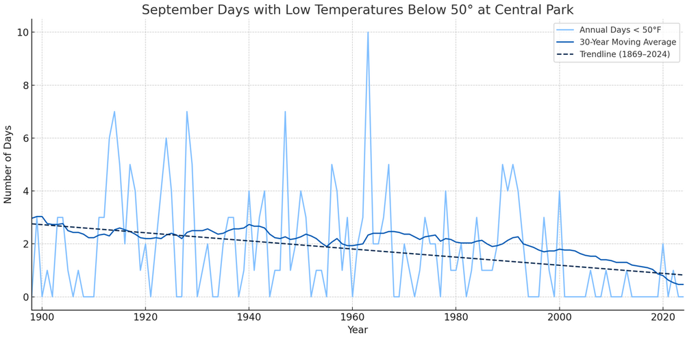
As September increasingly becomes an extension of summer, New York City has been experiencing a long-term decline in cases where September's coldest temperatures have fallen into the 40s. During 1961-1990, 83.3% of Septembers saw one or more lows in the 40s. September averaged 2.1 such days. During the current 1991-2020 baseline, just 33.3% of Septembers have seen lows in the 40s and the annual average has plunged to 0.8 days per year. The last time the temperature fell below 50° in September was September 24, 2022 when the mercury dipped to 49°. A strong argument can be made that September 2025 could buck that trend and experience one or more lows in the 40s. Based on the 8/29 12z NBM, August 20-31 will finish with five days with low temperatures falling below 60° at New York City's Central Park. The forecast lows for August 30 and 31 are 57° and 59° respectively. That would be the most such days since there were five days in 1987. The last time there were more was in 1946 when there were six. The record of eight days was set during August 20-31, 1940. Since record-keeping began in 1869, there were 16 cases when August 20-31 had five or more lows in the 50s and 81.3% of those cases saw one or more lows in the 40s during September. The figure for all other years was 65.7% of cases. Both cases with five or more days since 1980 (1986 and 1987) saw the lowest September temperatures fall into the 40s. The most recent year when August 20–31 had five or more lows in the 50s, but no September lows in the 40s, was 1934 when the monthly minimum temperature was 51°. In a city where concrete holds the heat and the climate grows steadily warmer, the return of a truly crisp September morning has become an increasingly uncommon and fleeting gift. Yet all signs suggest that September 2025 may break from recent tradition and deliver a breath from a vanishing earlier New York climate. -
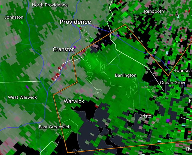
Just looked at radar and it’s looking like Spahn, Sain, and Stein.
-
I have Johnny Sains autograph. He came to Febway as a coach of the opposing team, forget which team. I didn't know who he was when I was 10 but my father said go get his autograph.
-
-
Only wild card for me is the North Atlantic water temps. You have to go back to around 2015 to find BN anomalies this time of year like we have now. Remains to be seen how that looks in a few months, but it's something. GFS control has the NAO negative for the first half of September more or less.
-
Yeah, seeing some rotation there.
-
Looks like some decent hail near Warwick, maybe a waterspout in Narragansett bay?
-
Southerly flow enhancing these storms now. Popped one over Warwick.
-
Tally of 90 degree readings so far this month
-
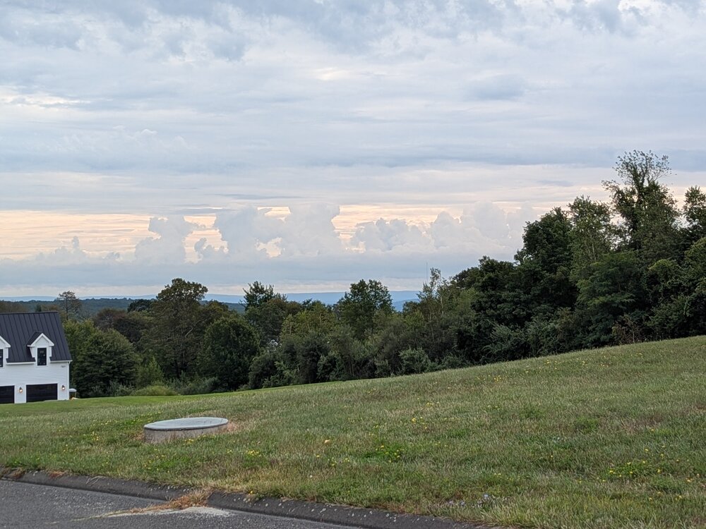
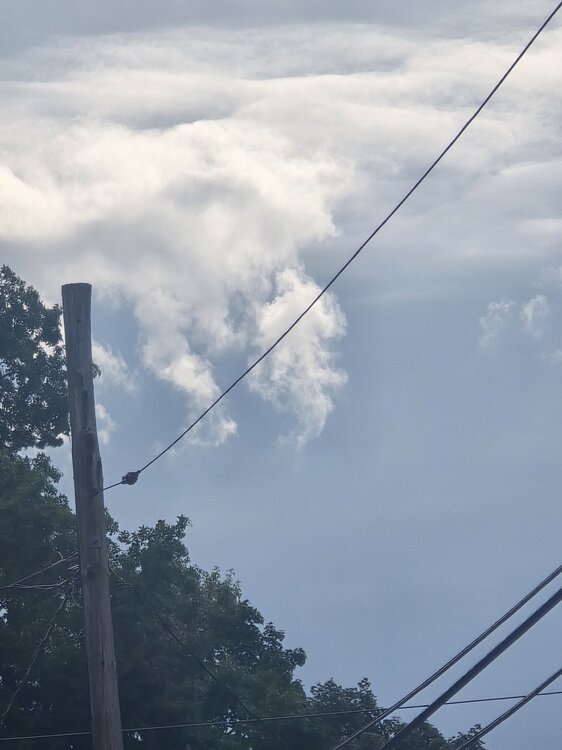
Lots of gravity wave clouds to my east. They are getting rocked.
-
-
-
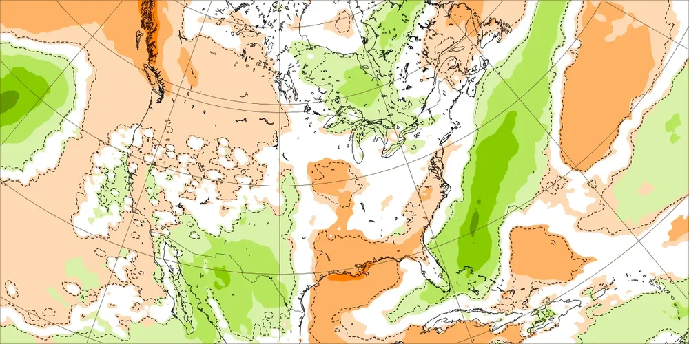
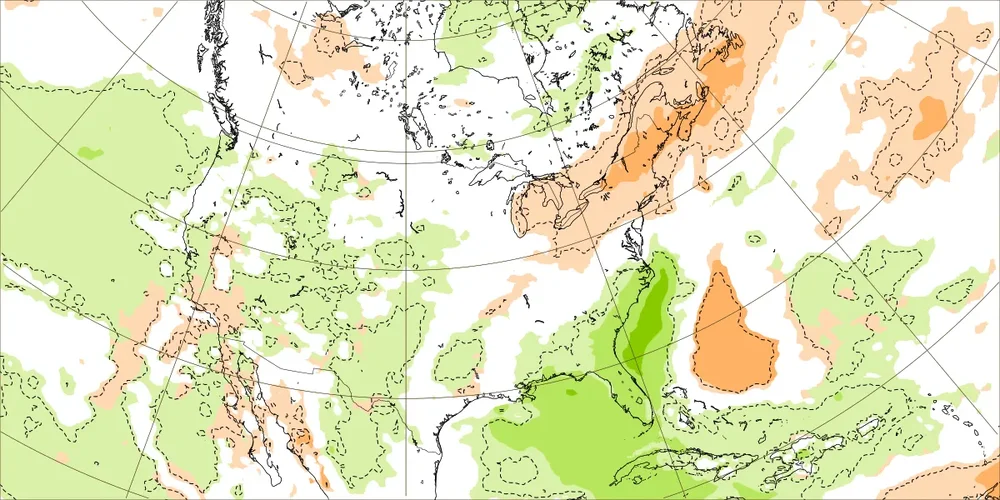
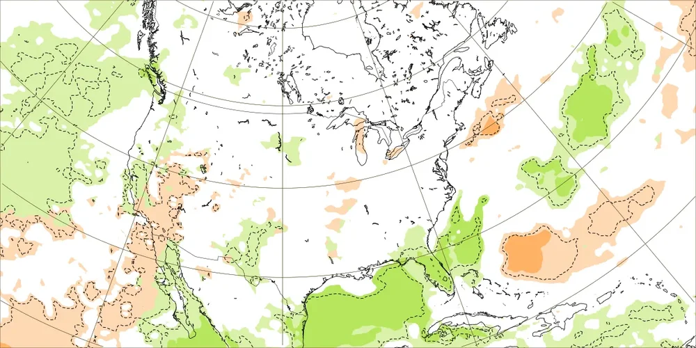
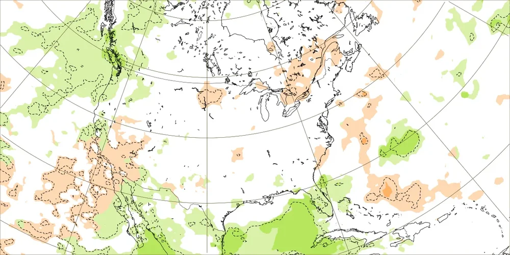
That’s a WxBell version of yesterday’s Euro Weeklies that covers 8/28-9/26 of 2025. I prefer to look at the output from the source, itself, ECMWF, as some WxBell maps are of questionable accuracy due to their algos: 9/1-7: slightly BN coastal MA (tan 1st shade is within 10 mm BN or <0.4” BN) and NN inland MA and all of NE 9/8-14: NN MA, slightly BN much of NE 9/15-21: NN 9/22-28: NN These 4 weeks don’t look as dry as the WxBell 30 day map implies. @mitchnick
-
Our run of dry and unseasonably cool weather looks to continue through at least the next week. Another cold front is crossing the area today and by later today winds will turn to the west, northwest, and become gusty. Dew points will fall into the 40's by evening and actual air temperatures will likely follow with widespread lows by Saturday morning in the chilly 40's. Some of our usual colder lower valley spots may be in the low 40's with even some 30's not out of the question. Some higher spots may not escape the 60's for highs tomorrow afternoon. Rain chances look low for much of the week before some chances of rain creeping back into the forecast by Thursday.
-
I don't see much to get excited about honestly. ENSO doesn't look inspiring and and the PDO region is bathwater right now. I'm not pessimistic like having a wall to wall disaster but my early guess is lining up cold air AND precip won't come easy. The optimist side of me is thinking that we will have some patterns that lock in some cold air for periods long enough for some real chances at winter wx. How things mix together is impossible to know at any range really. Overall my gut is feeling pretty ho hum based on history and playing this silly game for the last 20 years. Ma Nature is a complicated and unpredictable lady though. The rubber band will bend our way again. Your guess is as good as mine as to when lol. Would be nice to enter met winter with a BN Atlantic. Dec has real hard time working when a large parcel warm along the coast. That's doesn't look hostile right now but we have a long way to go before understanding that piece.
-

E PA/NJ/DE Summer 2025 Obs/Discussion
ChescoWx replied to Hurricane Agnes's topic in Philadelphia Region
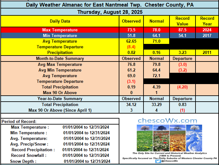
Our run of dry and unseasonably cool weather looks to continue through at least the next week. Another cold front is crossing the area today and by later today winds will turn to the west, northwest, and become gusty. Dew points will fall into the 40's by evening and actual air temperatures will likely follow with widespread lows by Saturday morning in the chilly 40's. Some of our usual colder lower valley spots may be in the low 40's with even some 30's not out of the question. Some higher spots may not escape the 60's for highs tomorrow afternoon. Rain chances look low for much of the week before some chances of rain creeping back into the forecast by Thursday. -
Since it hasn't begun raining here yet, we've had only the ditty's 2 days of rain this month, though not on consecutive days. Too young to have seen Johnny Sain pitch, but Spahn was a favorite with the big kick, deadly pick-off move and the best screwball since Carl Hubbell. His 16-inning duel with Juan Marichal at age-42 might be the best such game since the dead ball era.
-
I was afraid wxfella or tamarack were going to have to save me on that one.
-
Summer 2025 Medium/Long Range Discussion
TheClimateChanger replied to Chicago Storm's topic in Lakes/Ohio Valley
How did this work out? Akron, Ohio was supposed to get 3.5" of rain from the "biblical storm" and 4-5" over the 2 weeks. Instead, it will be the driest month on record - not just the driest August, the driest of ANY month. -
- Today
-

Central PA Summer 2025
Mount Joy Snowman replied to Voyager's topic in Upstate New York/Pennsylvania
Here's a new one......national low of 27 near Big Bay, MI. Looks like a ULL feature could control our weather late next week through the weekend, and then a possible warmup after that. Onward. -
I haven’t blocked him for the entertainment value. His forecast is the exact same literally every single year without fail for the past 20+ years. “Severe cold and snow in the east from Thanksgiving until New Year’s”. You can set your watch to it, wash, rinse, repeat

