All Activity
- Past hour
-
Why do you think the models trended south with this? Blocking.
-

Central PA Winter 25/26 Discussion and Obs
mitchnick replied to MAG5035's topic in Upstate New York/Pennsylvania
Fwiw, Nam is the coldest of it, the Euro and Gfs. Euro is a little cooler than half way between the other 2. That's as of 84hrs on the 18z runs. -

Central PA Winter 25/26 Discussion and Obs
Blizzard of 93 replied to MAG5035's topic in Upstate New York/Pennsylvania
I’m not sure what CTP is thinking for Friday, but they have not updated their forecast discussion at all in the long range portion. They updated their point & click grids this afternoon as a few folks mentioned, but they still aren’t addressing the growing concern for Wintry weather on Friday, which again will be a major travel day for many. -
Central PA Winter 25/26 Discussion and Obs
mitchnick replied to MAG5035's topic in Upstate New York/Pennsylvania
Good luck up there. You should get an inch maybe? I haven't looked that closely at tonight as I knew I was in line for a participation trophy at best. -

December 2025 regional war/obs/disco thread
WinterWolf replied to Torch Tiger's topic in New England
Is this Tomer any good? Does he know his stuff? -

December 2025 regional war/obs/disco thread
Damage In Tolland replied to Torch Tiger's topic in New England
https://x.com/burgwx/status/2003254205935681822?s=46&t=dhcbvkjmRcyBVQtDxJ3lRg -
Central PA Winter 25/26 Discussion and Obs
Blizzard of 93 replied to MAG5035's topic in Upstate New York/Pennsylvania
MDT & Lancaster airport are both down to 31 degrees this hour with dew points in the low 20s at MDT & high teens in Lanco. Precip at least aloft has broken out in western PA. -
That will guarantee you get high cirrus while Philly is on the northern fringe. Stay away from the bread and milk aisles until Saturday.
-

White Christmas Miracle? December 23-24th
ORH_wxman replied to Baroclinic Zone's topic in New England
BL gets kind of marginal down there. Prob flakes but could be white rain for a while. If you had some decent omega punching into the snow growth region, then it would prob rip. But this is a pretty weak system. -
December 2025 regional war/obs/disco thread
WinterWolf replied to Torch Tiger's topic in New England
Absolutely, Thank you. He’s already got himself missing it lmao, -
White Christmas Miracle? December 23-24th
Damage In Tolland replied to Baroclinic Zone's topic in New England
Dudes legit tiptoeing on ledge . Watch him get more than me -
An inch today up here. Exceeded expectations. Still -SN out there. It’ll look like an underperformer all day, and then go right to fluff after sunset.
-
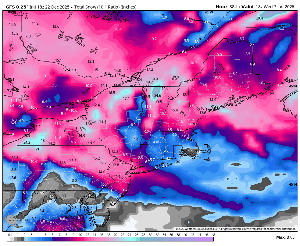
12z Eps snowfall on top and 18z below. I see movement south. Subtle, but it's there.
.thumb.png.29e14eca01642c9c6cadf37138d8aab4.png)
.thumb.png.3b8d5149c36429f71f586bdb8d821f19.png)
-
It’s hard to take anything good or bad for that system seriously when just yesterday it had rains to Maine
-

White Christmas Miracle? December 23-24th
TauntonBlizzard2013 replied to Baroclinic Zone's topic in New England
Feel like the warmth is being overdone in my location. The rates just might suck and it’s so weak, but I doubt we’ll be torched -
Moisture slamming into a cold dome could yield a lot of snow but agree that it's very unlikely to be this far south unless blocking is very strong
-
.thumb.png.4150b06c63a21f61052e47a612bf1818.png)
White Christmas Miracle? December 23-24th
HIPPYVALLEY replied to Baroclinic Zone's topic in New England
That would be zero accumulation for much of MA. .05” qpf spread over 8 hours. -
December 2025 regional war/obs/disco thread
WinterWolf replied to Torch Tiger's topic in New England
Well, you can see TBlizz starting to hint and show his hand already…he’s revving up for a tirade of negativity. This thing will waffle over the next few days…we gotta roll with it for a bit. As Will Said, anything from this is a bonus anyway. -

White Christmas Miracle? December 23-24th
weatherwiz replied to Baroclinic Zone's topic in New England
Hoping for 1.5” tomorrow and that will get me to about 7” for the season and only 93” away from 100”!!! -
Quit trying to excite Weather Will like that.
-

December 2025 Short/Medium Range Forecast Thread
Golf757075 replied to John1122's topic in Tennessee Valley
Carver, I think if the mjo gets active, it should allow the pacific to align for cold here for a few weeks, providing the mjo moves along imo -
White Christmas Miracle? December 23-24th
ORH_wxman replied to Baroclinic Zone's topic in New England
He’s so close to water which may be an issue for a time until winds go more N or NW. Light snow and 33-34 might struggle. -
Always been my thought process. But some still enjoy useless cold and 4 hours to get an inch events over 60s in the winter.
-

December 2025 regional war/obs/disco thread
powderfreak replied to Torch Tiger's topic in New England
That run was a clipper parade. Your new spot will continue to clean up with us in NNE if we get energy every couple days coming in from the NW and plenty of cold. The difference from your area to the eastern Adirondacks is pretty stark in these types of patterns.


.png.4dfaa19b055bdf15ab8991e83270a06c.png)
.png.162ca8e39608dcb2657b57e747fc73db.png)