All Activity
- Past hour
-
Up to an 1.5” here and that coastal band is set up right over us. Beautiful baby!
-
Good BAM video. Looks like we need November and December to rock...what could possibly go wrong?!
-
 Through 9 am, rainfall amounts have been pretty much in line with expectations for the ongoing event.
-
 If this were winter...I'd say wait to crow until midnight tonight. MUCH more to come today. 1-2", iso heavier coasts and even interior will do ok. Convection developing per HRRR - might be quite a nasty afternoon parts of coasts. Am pretty sure some parts Li and eastern Nj will end up with 4". CoCoRaHs two day. .31 Wantage since 5P yesterday. Two day .4, heading for .6-1.0 three day totals by tomorrow morning. Click for more detail.
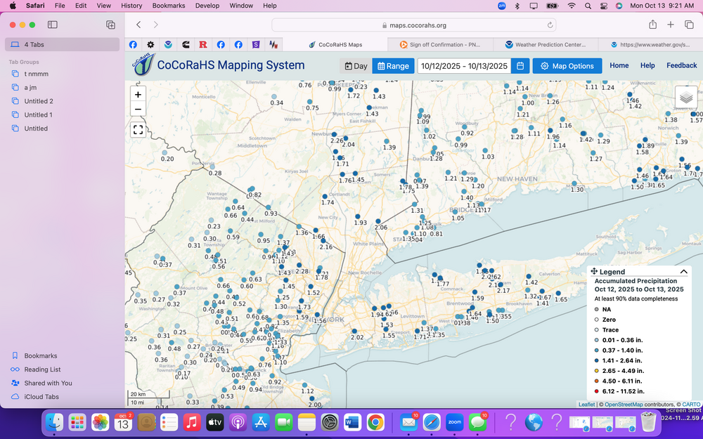
- 569 replies
-
- 1
-

-
- heavy rain
- damaging wind
- (and 2 more)
-
 Definitely heard those big gusts at 3 am, the 48/49 at FRG and ISP line up. A few house shakers woke me up
 -
2.26” and a lot more to come
-
BULLETIN Tropical Storm Lorenzo Advisory Number 1 NWS National Hurricane Center Miami FL AL122025 500 AM AST Mon Oct 13 2025 ...TROPICAL STORM LORENZO FORMS OUT IN THE CENTRAL TROPICAL ATLANTIC... SUMMARY OF 500 AM AST...0900 UTC...INFORMATION ---------------------------------------------- LOCATION...14.2N 40.3W ABOUT 1095 MI...1760 KM W OF THE CABO VERDE ISLANDS MAXIMUM SUSTAINED WINDS...45 MPH...75 KM/H PRESENT MOVEMENT...NW OR 305 DEGREES AT 17 MPH...28 KM/H MINIMUM CENTRAL PRESSURE...1006 MB...29.71 INCHES ——————- FORECAST POSITIONS AND MAX WINDS INIT 13/0900Z 14.2N 40.3W 40 KT 45 MPH 12H 13/1800Z 15.0N 41.7W 40 KT 45 MPH 24H 14/0600Z 16.2N 43.4W 40 KT 45 MPH 36H 14/1800Z 18.0N 44.4W 45 KT 50 MPH 48H 15/0600Z 20.1N 44.7W 50 KT 60 MPH 60H 15/1800Z 22.4N 44.2W 55 KT 65 MPH 72H 16/0600Z 25.1N 42.6W 60 KT 70 MPH 96H 17/0600Z 30.9N 36.9W 55 KT 65 MPH 120H 18/0600Z 33.2N 29.6W 45 KT 50 MPH $$ Forecaster Papin
-
 About 1.08" at Newark so far...
 -
1.4" since midnight. check. excessive rainfall has been normalized to such a degree that "normal" rainfall is underwhelming.
-
 Haha yup, just .11" here of mostly mist. Since we had a freeze and the garden is dead and grass mostly is done growing, I'm happy not to get the 1"+ rains. Dogs won't be muddy and soaked when they come in from their potty breaks. If it was winter though, it would have sucked, though its happened plenty of times.
 -
VT is a relatively small program compared to the others that you've listed, but that isn't necessarily a problem. I don't feel like meteorology has the same "ranking" hierarchy like law schools or business schools do. It is more about what skills you can develop. One thing to recognize is that meteorology has a very high "quit" ratio. A lot of students are attracted to it for all the same reasons why we are on this board, but the math and physics weeds out a lot of them, so it is always good to keep your options open. And with the job market the way it is and AI looming, the best candidates for jobs in the future in meteorology are probably going to be people that have diversified in some way. So, things like computing/AI, emergency management, energy, transportation, etc. The days of just getting a standard meteorology Bachelor's degree and then getting hired right away by the NWS or media is not dead, but a dwindling path.
-
Dual swirls Southeast off Carolinas and southeast of South New Jersey
-
Thanks, Don. It’s probably due to randomness, but keep in mind that the last 3 Euro Oct winter forecasts did poorly as they all missed in the NE US by 3-4F (two too cold and one too warm). Those are the 3 largest misses of the last 8 October NE winter forecasts. OTOH, the prior 5 October forecasts’ avg miss was only 1F.
-
SST Annomaly s
-
 .52 here sharp cutoff within the county
 -
Records: Highs: EWR: 89 (1954) NYC: 87 (1954) LGA: 86 (1995) JFK: 79 (1995) Lows; EWR: 34 (2012) NYC: 34 (1875) LGA: 39 (1988) JFK: 37 (2012) Historical: 1820: Snowstorm at Ft. Snelling, MN dumps 11 inches. (Ref. AccWeather Weather History) 1846 - A great hurricane tracked across Cuba, Florida, Georgia, the Carolinas, Virginia and Pennsylvania. The hurricane inflicted major damage along its entire path, which was similar to the path of Hurricane Hazel 108 years later. The hurricane caused great damage at Key West FL, and at Philadelphia PA it was the most destructive storm in thirty years. (David Ludlum) (The Weather Channel) 1876: New York City recorded its earliest 32° reading with a half inch of snow. Snow fell from Virginia to New England with 3.5 inches reported at Fall River, MA. (Ref. AccWeather Weather History) 1893: At Richmond, winds became a "perfect gale" as rain fell in torrents. Homes were partially unroofed, and trees fell in the capital squares. Between Richmond and Danville, a passenger train struck a fallen tree while a freight train struck another tree. Many lines fell across Petersburg. Dwellings in town rocked to the wind gusts. Roanoke watched as their river rose to levels unseen since 1853. Washouts occurred along the Norfolk & Western railroad, delaying traffic from twelve to fourteen hours. The town of Elliston was submerged by the Roanoke river, sweeping away houses. Alexandria saw its wharves crumble before the high waters ($25,000). The James river eclipsed the level attained during the Johnstown Flood of 1889 by twelve inches. Bladensburg saw winds level fences and partially unroof homes. In Washington, DC, the Calvary Baptist church's side wall blew down ($3000). Associate justice of the Supreme Court Henry B. Brown was seriously injured when a plate glass window shattered at his new home at the northwest corner of 16th street and Riggs at 7:30 p.m.. Trees and their limbs were strewn throughout the city. Rainfall began in the morning and increased throughout the afternoon. Sewers were flooded by this downpour. By 6 p.m., gale force winds swept through the Federal City. Damage to police and fire wires was "greater than ever before been experienced. " Waters on the Potomac rose six feet above the high tide, which was three feet below the high water mark. The Anacostia bridge became submerged. (Ref. for Fall Storm of Oct. 13th - 14th) 1960: Large hail nearly covered the ground across a large part of central Jackson County, in southwest Oklahoma. Hail up to the size of baseballs, with some chunks shaped like saucers, destroyed the roofs of most businesses and homes in Olustee. Large hail also pounded the Stillwater area the same evening. Hail up to 4 inches in diameter caused damage in and around the city, including damage to roofs, windows, and copper trim at Oklahoma State University. (Ref. Wilson Weather History) 1982: Denver experiences a wet, early-season snow. Up to 6 inches fell in the Foothills. Extensive power outages resulted as tree limbs broke under the weight of the snow. (Ref. AccWeather Weather History) 1983: Severe weather in Falls Church, VA, produced 2-3 tornadoes and caused $1 million in damages. 1986 - Four tornadoes struck southeastern Virginia late in the night causing three million dollars damage. Tornadoes at Falls Church VA caused a million dollars damage. (Sandra and TI Richard Sanders) 1987 - Fifteen cities in the eastern U.S. reported record low temperatures for the date. Record lows included 34 degrees at Meridian MS, 28 degrees at Paducah KY, and 26 degrees at Beckley WV. Another surge of arctic air entered the north central U.S. bringing snow to parts of Wyoming and Colorado. (The National Weather Summary) 1988 - A total of forty-three cities in the eastern U.S. and the Upper Midwest reported record low temperatures for the date, including Elkins WV and Marquette MI where the mercury dipped to 18 degrees. (The National Weather Summary) 1989 - Sixteen cities reported record high temperatures for the date as readings warmed into the 80s and low 90s from the Southern and Central Plains to the Southern and Middle Atlantic Coast. Evansville IND and North Platte NE reported record highs of 91 degrees. (The National Weather Summary) 1990: The combined remnants of Tropical Storms Klaus and Marco dumped extremely heavy rainfall over New England. More than 6 inches of rain fell in parts of Connecticut. (Ref. AccWeather Weather History) 1994: A slow moving low pressure area dumped excessive rains over coastal Georgia. Hunter was drenched with 14.26 inches in 24 hours while Savannah checked in with 8.80 inches. (Ref. AccWeather Weather History) 2006: On the 12th and 13th in a historic lake effect snow left 22.6 inches of snow in Buffalo, New York. With trees in full leaf much damage occurred; estimates of $200 million dollars damage. Thunder occurred for approximately 12 hours with the storm, and 400,000 customers without power some for two weeks. (Weather Guide Calendar with Phenomenal Weather Events 2007 Accord Publishing, USA) (Ref. Weather Guide Calendar with Phenomenal Weather Events 2012 Accord Pub. 2011, USA) 2011: Central and eastern Virginia hit by three tornadoes today. The tornado that hit New Kent County on Thursday carried winds estimated at 95 mph, the National Weather Service said today. The twister struck about 4:50 p.m. in the Woodhaven Shores neighborhood in southwestern New Kent, officials said. Its path was about 200 yards wide. The tornado was an EF1 -- the next-to-weakest rating for tornadoes. Weather service officials judged the tornado's characteristics by visiting the site today. Earlier today, the weather service said three confirmed tornadoes struck Virginia Thursday the 13th of October. The tornadoes hit western Louisa County between 3:30 and 3:45 p.m., western New Kent County just before 5 p.m. and southeastern Prince William County about 5:30 p.m. (Ref. Richmond Times Published by Rex Springston on October 14, 2011) A late season tornado event occurred on October 13th. An EF1 tornado went across a portion of New Kent County and another did EF1 damage in Louisa County at Sylvania Plantation, a historic home built in 1746. (Ref.NWS Late Season Tornadoes Louisa County and New Kent County)
-
Since just a few miles inland, most of the precipitation was light, I would imagine that the same event in February would have been just a wintry mix.
-
If this were winter, a lot of us would have been greatly disappointed...
-
55 / 53 with 0.72 in the bucket lots of mist and drizzle - sheet drizzle. Ugliness tames down later tonight and drying out Tue and perhaps some sun by Tue afternoon or sunset. Drier week and perhaps a quick 70 on Wed before a 48 hour cooler airmass comes down mainly Wed evning - Fri AM. Perhaps some frosts inland. Warmer by Friday afternoon and this coming weekend looks nice with Sunday back to the 70s for most. A bit back and forth starting on the 20th with overall warmer outweighing the cooler beyond.
-
They pretty much only shut down for southeasters, which make it impossible for the boat to dock properly. But for anything short of a cat 1, they can keep running boats.
-

Central PA Fall Discussions and Obs
pasnownut replied to ChescoWx's topic in Upstate New York/Pennsylvania
Looks like Elliot gets an atta boy on his forecast. -
 Driving along 25A, appeared 2 cars got hit by a fallen branch in East Norwich earlier. Police were on scene with one car on flatbed tow truck with a crushed front roof and windshield destroyed. The other car was just being loaded on to another tow truck.
- 569 replies
-
- 1
-

-
- heavy rain
- damaging wind
- (and 2 more)
-
 1.35 inch of rain so far but more looks to be moving in. Peak gust at my station 34mph.
 -
 Chilly with drizzle here
 -
 What is with the neverending firing up of rain along the Jersey shore? You would think there were mountains going down the spine of the state.


