All Activity
- Past hour
-
Orpheum in Boston.
-

September 2025 OBS-Discussion centered NYC subforum
PhiEaglesfan712 replied to wdrag's topic in New York City Metro
Barring a 10/2/2019 event, this should be all she wrote for the summer weather until next season. -
-
You just don’t get it and are unable to follow along are you ?
-
Pretty meh overall here yesterday, 0.85" with a weak cell, Stronger ones were north and south of here.
-
0.36" overnight and still dzl. So over 0.5 for both days (so far)
-
Garage sale fail. Closed up shop already. 1 person stopped since 8am. Good to get the much needed rain though. Anti-Stein.
-
Wow. Is the black line 2021?
-
E PA/NJ/DE Autumn 2025 Obs/Discussion
PhiEaglesfan712 replied to PhiEaglesfan712's topic in Philadelphia Region
Drought guy wrong again. I've been drought free since March 5. -
Hibbing was at 29 yesterday morning for a 1st place tie with 2018. 30 this morning. Back to more seasonable wx this week. Saw this in the records from Grand Forks. RECORD EVENT REPORTNATIONAL WEATHER SERVICE GRAND FORKS300 AM CDT FRI SEP 5 2025...RECORD LOW MAXIMUM TEMPERATURE SET AT THE GRAND FORKS UNIVERSITY/NWS CLIMATE STATION FOR THURSDAY SEPT 4TH...THE HIGH TEMPERATURE ON THURSDAY SEPTEMBER 4TH AT THE NATIONAL WEATHER SERVICE IN GRAND FORKS WAS 48 DEGREES. THIS SETS A RECORD FOR THE COLDEST HIGH TEMPERATURE RECORDED FOR THIS DATE. PREVIOUS RECORD LOW MAXIMUM TEMPERATURE WAS 55 IN 1956. LOOKING AT RECORD DATA BASE FOR THE CITY OF GRAND FORKS (1893 TO PRESENT), THIS IS ALSO THE EARLIEST DATE WHEN THE HIGH TEMPERATURE WAS BELOW 50 DEGREES WHEN LOOKING AT THE FALL MONTHS OF SEPTEMBER AND OCTOBER. THE PREVIOUS EARLIEST HIGH TEMPERATURE BELOW 50 DEGREES WAS SEPTEMBER 12 1961 WHEN THE HIGH TEMPERATURE WAS 49. THE RECORD DATABASE SHOWS THE AVERAGE DATE OF THE FIRST BELOW 50 DEGREE HIGH IN THE FALL IS OCTOBER 3RD. THIS IS USING THE RECORD DATABASE FROM 1893 TO CURRENT.
-

2025 Atlantic Hurricane Season
BarryStantonGBP replied to BarryStantonGBP's topic in Tropical Headquarters
Joe Bastard said there are similarities with this year and last year with the mjo placements only difference was that last year had lower amplitude so anyone screeching season cancel should sod off -
Where? I’d love to see them.
-
About 0.4" now for the last 24 hours. 0.55-0.6" for September. Not bad, but nothing at all on the horizon for the next 10-15 days except pleasant fall weather.
-

September 2025 OBS-Discussion centered NYC subforum
weathermedic replied to wdrag's topic in New York City Metro
1.39 so far at my station -
Nailed it.
-
Done here. 58.0° 0.24” between yesterday and today. 0.98” Aug-Sep total with little on the horizon. The next 2 weeks look Steined.
-
@Bluewave Once again, tropical forcing staying in the IO and the Maritime Continent regions…..
-

September 2025 OBS-Discussion centered NYC subforum
psv88 replied to wdrag's topic in New York City Metro
2.15”, based on radar 3” isn’t out of the question. Major short term bust -
Just over an inch since yesterday, which is more than I got in August
-
1.93 here already and it's not slowing down.
-
International Falls got down to 29 this morning. Bemidji was 32.
-

2025 Atlantic Hurricane Season
bigtenfan replied to BarryStantonGBP's topic in Tropical Headquarters
When is the last time on Sept 7 the NHC site showed zero disturbances in the next 7 days. -

September 2025 OBS-Discussion centered NYC subforum
Sundog replied to wdrag's topic in New York City Metro
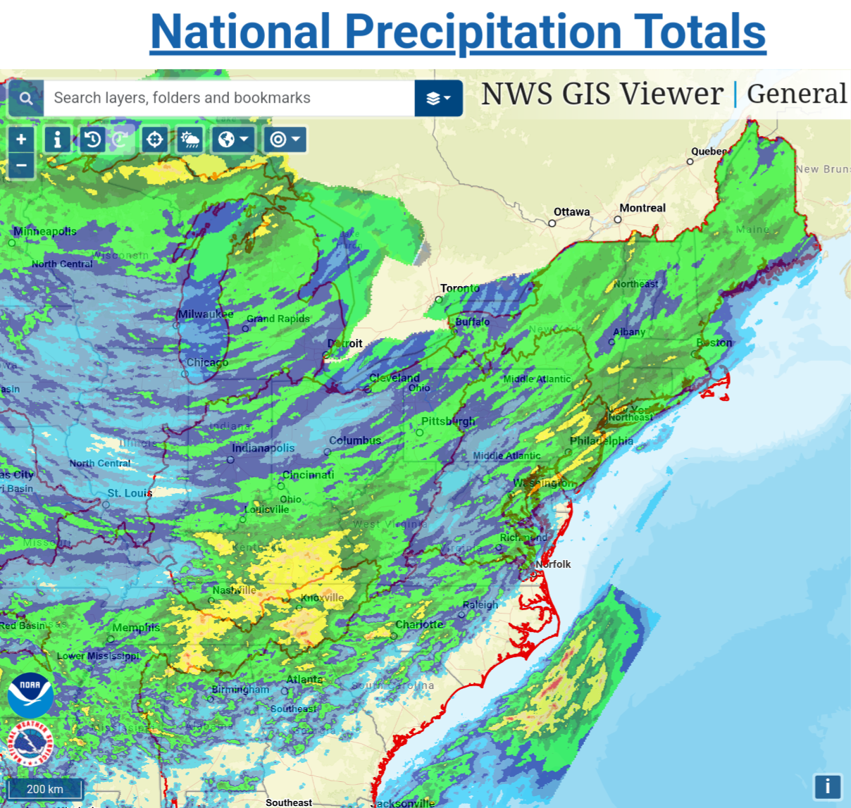
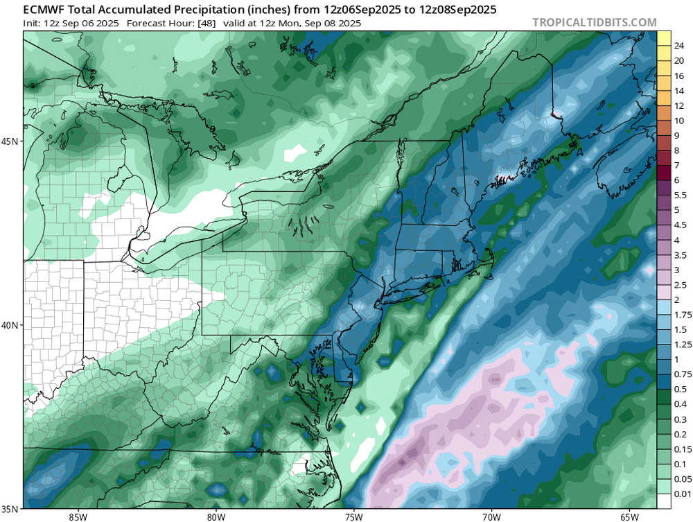
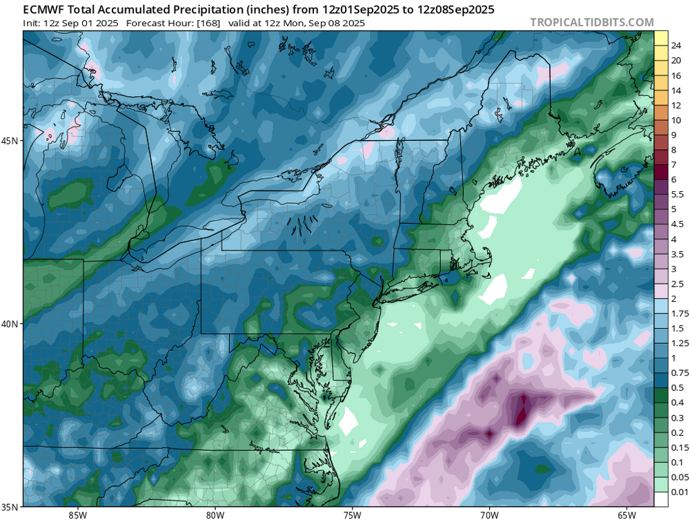
The models or long term predictions saying September would open up very dry were a bust (thank goodness.) This is the first 7 days of the month: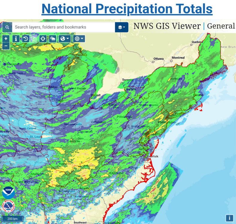
-

September 2025 OBS-Discussion centered NYC subforum
bluewave replied to wdrag's topic in New York City Metro
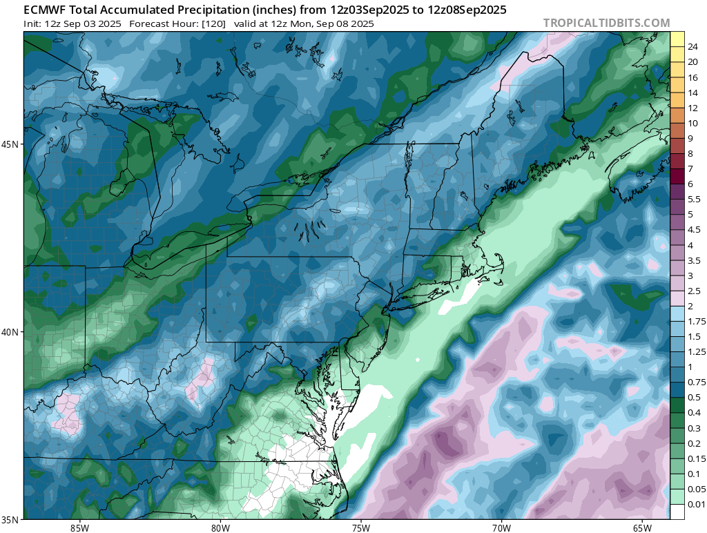
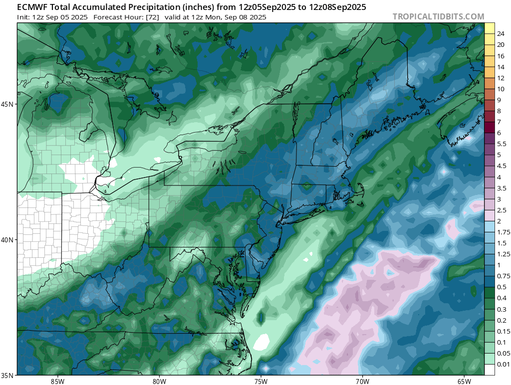
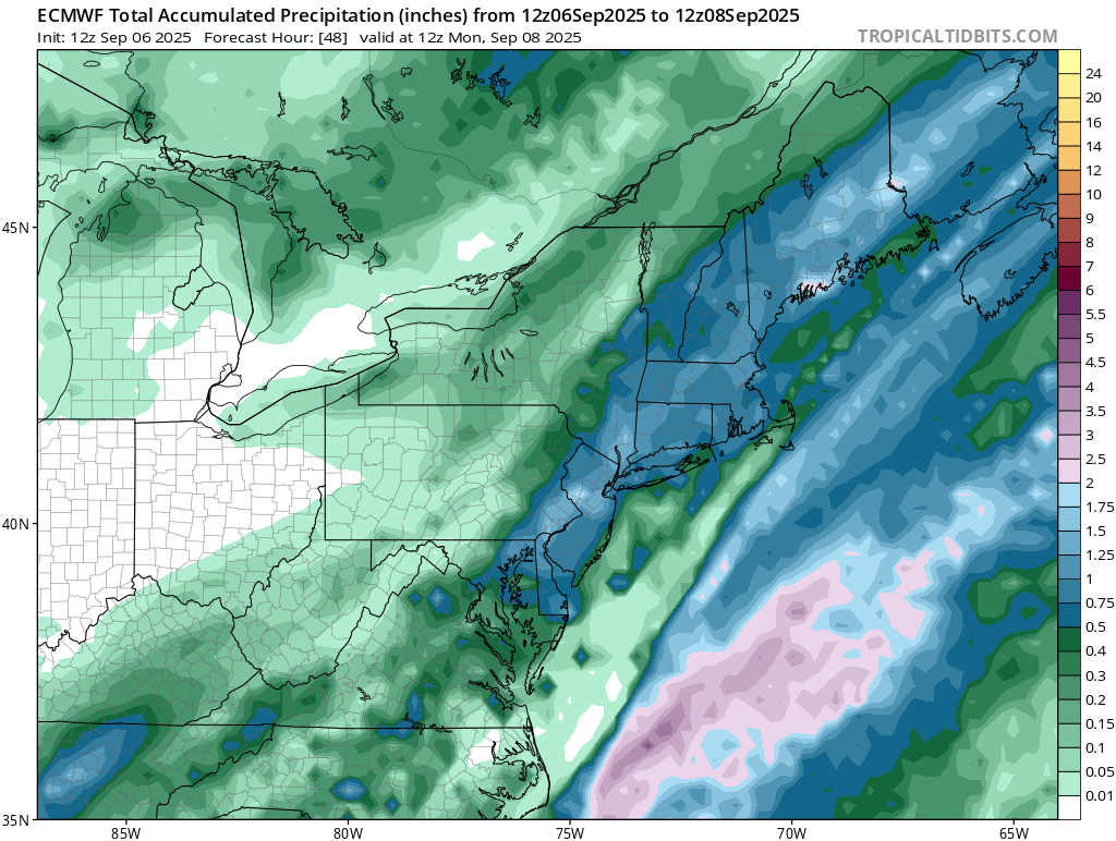
Was nice to so see a forecast rainfall axis actually shift east over time like the models started doing a few days ago.

-
Rain, glorious rain. Much needed. Take