All Activity
- Past hour
-
We have seen this before keeping clocks locked (ST / DST) and i continue to think that the likely outcome is keeping it the way it is. https://www.spokesman.com/stories/2026/may/22/permanent-daylight-saving-time-bill-takes-one-step/ https://www.washingtonpost.com/politics/2026/05/19/house-gop-resurrects-trumps-plan-year-round-daylight-saving-time/
-
Drove north to find better weather. 69 and beautiful in Syracuse
-
Got 0.18” from a passing cell, .43” for day 1.78” MTD
-
Northern Pike
-
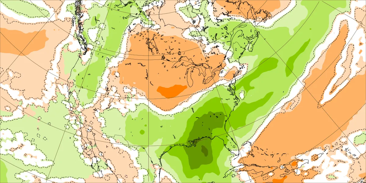
 Since Summer 2002, just about every super dry period has been equaled out thereafter by super wet. This year we have an El Nino seemingly kicking in.
 -
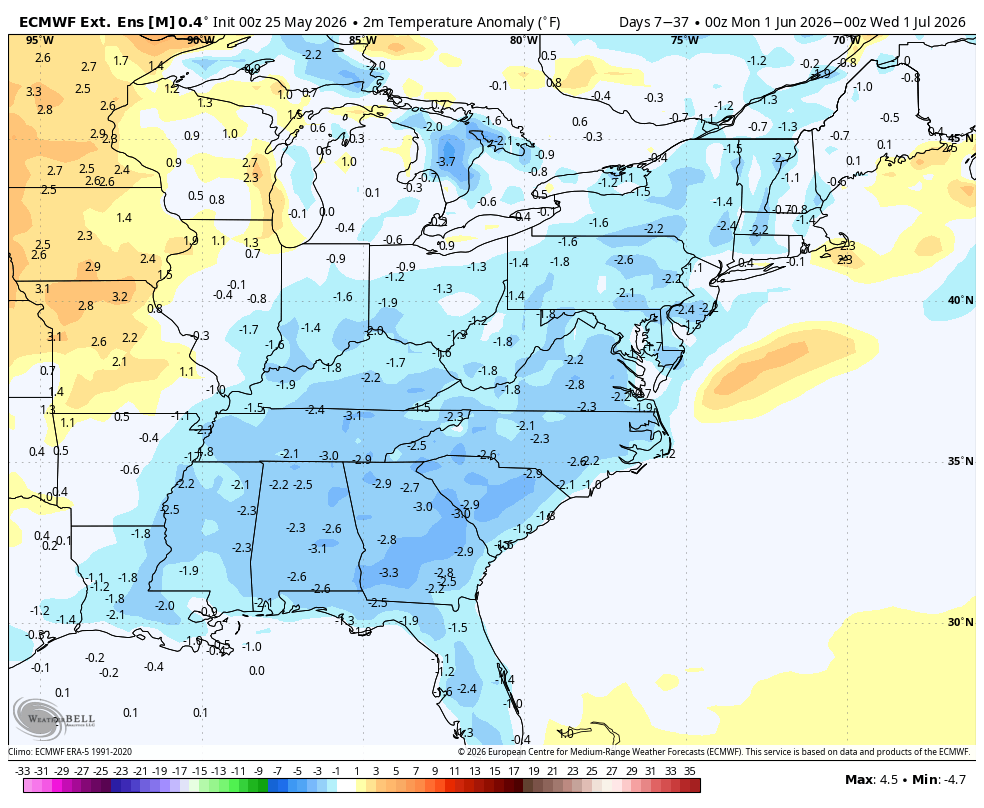
 WB latest EURO weeklies for June. No big heat....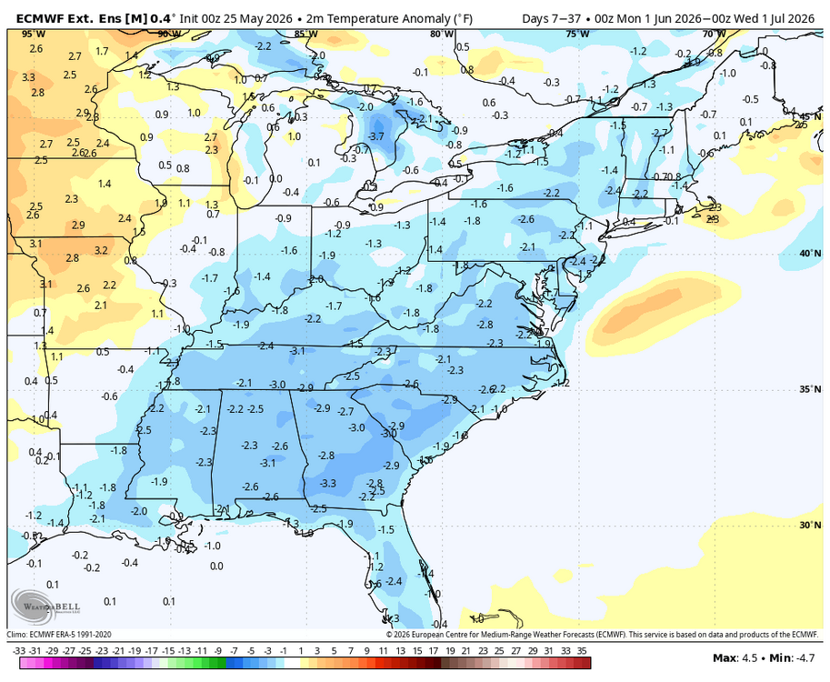
-
Didn't this happen last week? 80 to 90, Mon-Wed, followed by a piece of shit weekend? huh
-
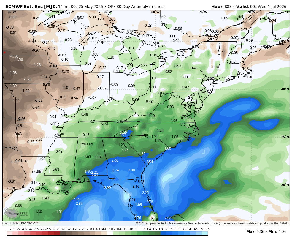
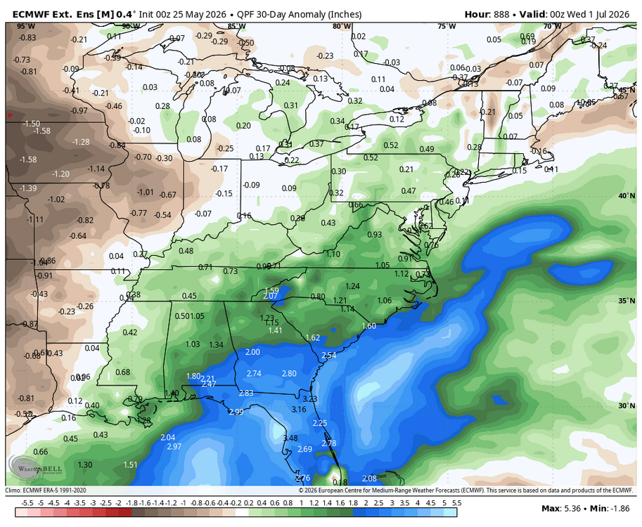
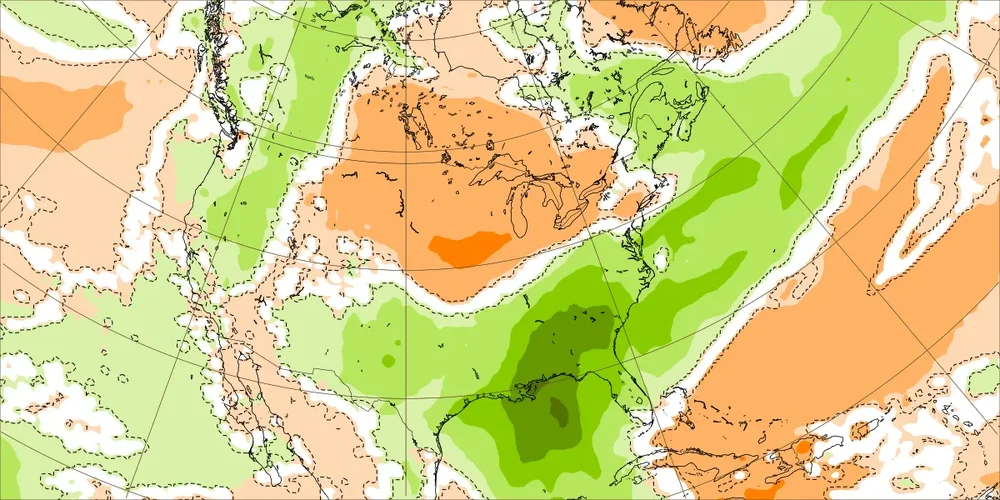
Today’s Euro rainfall for 5/25-31: still very impressive with even heavier for parts of AL/GA/SC (dark green area, which has ~3.5-4”+, is larger) although not quite as wet for E NC/Triangle/Triad as yesterday’s even though still quite wet. This would be what the drought doc ordered/dream come true. This is one of the most widespread very heavy Euro weekly rainfall maps outside of a tropical cyclone that I’ve ever seen! Many tropical cyclones don’t produce this much over such a large area! For this reason, although I’ve once again gotten nothing measurable and have had only 0.3” for the last 3+ weeks (its been like there’s a force-field here), I’m still excited about the prospects:
-
Alligator gar?
-
all the way to 78 here in Ayer. wow. That 77 next door in KFIT's a pretty big MOS bust
-

Central PA Spring 2026 Discussion/Obs Thread
canderson replied to Voyager's topic in Upstate New York/Pennsylvania
It’s gross. And feels very warm like many think Memorial Day should be. House AC is on now. -
Is that you on the left in green jacket?
-
Warmer temperatures lie ahead. The temperature will rise to above normal levels for tomorrow through Thursday. Exceptional heat is unlikely. It will turn somewhat cooler to end the week. The ENSO Region 1+2 anomaly was +2.1°C and the Region 3.4 anomaly was +1.0°C for the week centered around May 20. For the past six weeks, the ENSO Region 1+2 anomaly has averaged +1.72°C and the ENSO Region 3.4 anomaly has averaged +0.83°C. The ongoing El Niño will continue to strengthen through the summer. The SOI was -25.41 today. The preliminary Arctic Oscillation (AO) was +1.581 today. Based on sensitivity analysis applied to the latest guidance, there is an implied near 70% probability that New York City will have a warmer than normal May (1991-2020 normal). May will likely finish with a mean temperature near 63.8° (0.6° above normal). Supplemental Information: The projected mean would be 1.3° above the 1981-2010 normal monthly value.
-
That was a crazy game. They were out of it so many times. Got saved by the overturned call at home.
-
You may get it!
-
Cowser with back to back days with a walk off home run. I mean you can't make it up.
-
What a recovery…total 180 from the morning. Pretty awesome outside
-

Occasional Thoughts on Climate Change
donsutherland1 replied to donsutherland1's topic in Climate Change
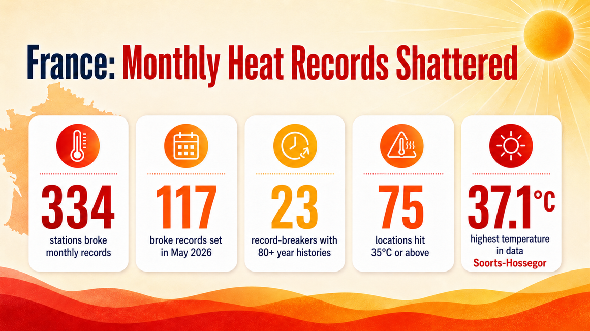
The final numbers from today's historic heat in France: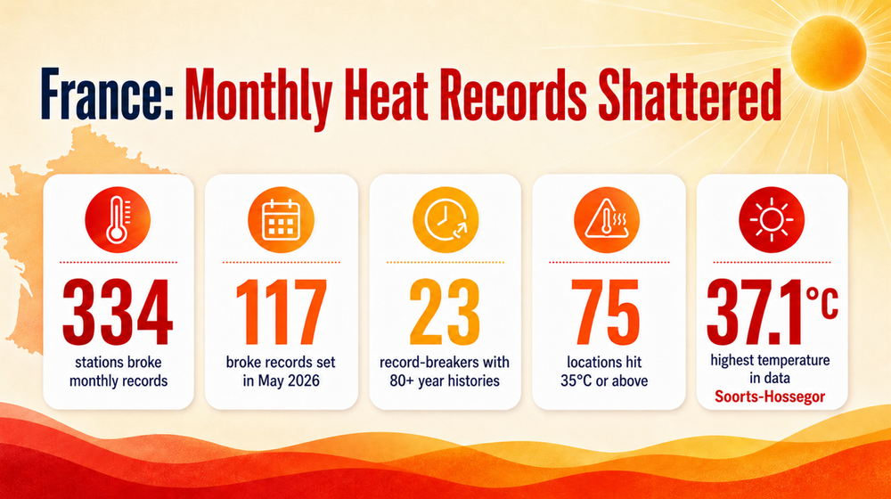
-
LOL Orioles
-
Turned out way nicer and earlier than previously thought. I guess half a day out of 3 whole ones will have to do. The remaining 85% of the weekend blew chunks no matter what a certain red tagged from SNH says
-
Picked up 2 inches today, with more on the radar headed my way.
-
That looks awful.
-
Northern Pike?
- Today
-

Central PA Spring 2026 Discussion/Obs Thread
TheDreamTraveler replied to Voyager's topic in Upstate New York/Pennsylvania
Today is way more humid than I thought it'd be