All Activity
- Past hour
-
Solid garden variety storms rolling through the metro this morning. Needed the moisture after a couple dry weeks.
-
This next one has a better chance than Erin did, relative to the outlook range, spanning the eastern continent and adjacent SW Atlantic Basin. Note, better chance does not mean this: The CPC's handling of the PNA index has it rising positive, while the NAO is bucking for a vague negative. That's all but a 101 requirement, particularly if the latter is over the western limb. To soon to know if that's the case but just numerically, this is a better canvas. Erin never even had an easel. Anyway, the idea of a warm up mid month still does not have a lot of legs in the index spread. It matters. If we succeed in doing so, this idea dries up. Can't really have both. A pattern relaxation will likely ensue beyond this trough anomaly deal through the Lakes. The operational runs will tend to bounce the pattern aggressively the other direction, and by that I mean too much. The index/PNA rising seems in conflict here. I could see the flow relaxing, and by virtue of that... yeah, warming, but uuusually, a rising PNA doesn't set the table of eastern/WAR -like response. It's interesting... a period of some competing indicators. I tend to lean on the ensembles, however. So, meanwhile, the MDR reactivates here over this week. Any TC born out of that may find a position not as polarward as the GFS is attempting by circa D6/7. This is also a known bias at long leads regarding operational guidance, definitely with that particular model. Having too much "beta drift" (sus therein), it likes to move these systems into the Sargasso Sea while maintaining a west track at like 36 N.. Compensating for these behavior biases may see a TC closer to the NE Windward Islands by D6 or 7 ... which also fits the EPS, although I that forecast system seems a little weak considering the favorable main metrics of lowering shear, ample OHC, and lowering SAL. All these facets ... mmm, I won't calling them compelling just yet. Too strong. But, I'm willing to actually look at the models this time. LOL
-
-

2025 Atlantic Hurricane Season
BarryStantonGBP replied to BarryStantonGBP's topic in Tropical Headquarters
no wonder models had a wcar/gulf threat it'll go on and off for now -
EP, 12, 2025090212, , BEST, 0, 179N, 1074W, 35, 1005, TS, 34, NEQ, 30, 20, 0, 20, 1009, 100, 30, 0, 0, E, 0, , 0, 0, LORENA, S, 0, , 0, 0, 0, 0, genesis-num, 021,
-
we used to get cold fronts with an inch of rain
-
Yep, flaccid.
-
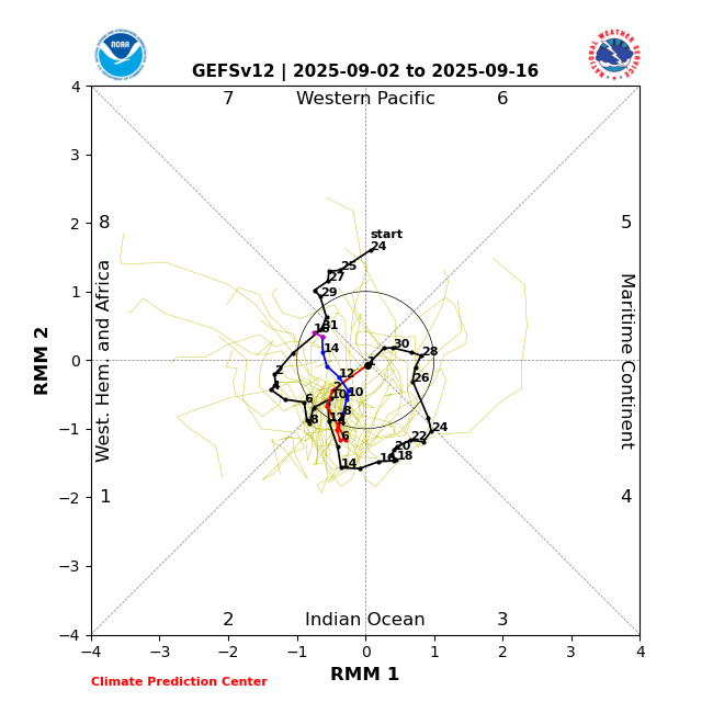
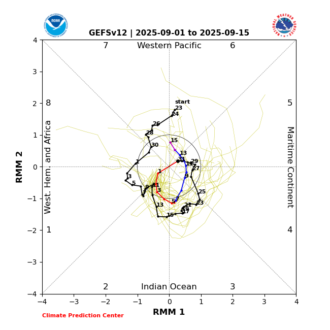
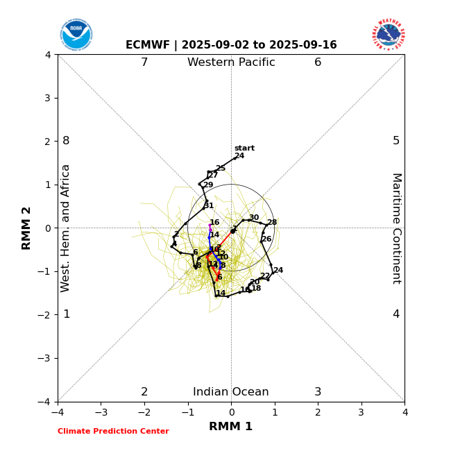
Wow, what a massive fold by GEFS to EPS in today’s MJO forecast! Whereas the EPS is similar to yesterday’s idea of not going to the right side (MC), GEFS abandoned the typical counterclockwise path that it had yesterday through MC and then to 6/7. Today, it remains in 2 through 9/11 and then crawls “backwards” up to 1 followed by 8 as of 9/16 (all mainly inside the circle, i.e., low amp). The EPS is very similar: Today’s (9/2) GEFS prog: Compare today’s GEFS to yesterday’s (9/1) GEFS prog: huge change! Thus, 9/2 EPS, which is very similar to 9/1 EPS, is very similar to 9/2 GEFS as it also ends up in low amp 8:
-
Mmm not right. The bold is a miss-representation of both intent, but even black and white written word. For someone that spends the amount of time as you do, composing these various articulations, you should perhaps spend as much focus for clarity on the other side of the pen. "... if this winter behaves incongruently more so than "average weirdness" ( haha ), which again... was suggested by climate model/predictions all along ( so is not unprecedented in that sense, the rise in 'unpredictability') ... it's fair to consider the classical methods are becoming less reliable. .." I've always made it clear ( ... when not being a snarky douche on purpose because it is fun to spark off meaningless internet fights haha ) that this is an art of tendencies. "Less Reliable" intimates that to the objective reader. That is not "John seemingly disregarding" anything. Aside from the fact that multiple other times, I literally have to write the sentence, "keep in mind, this is tendency" - which shockingly, never seems to penetrate or modulate the readers comprehension, particularly when having to do so violates the dignity of the curvaceous winter model. Gee. I mean come on... we're past this, or should have been 20 fuckum years ago, or whenever it was that we learned climate is a jagged serrated affair over time. The trend is not arguable. Your winters are suffering. That tendency model is constructed by the deeper trend analysis. Not by these transient seasonal teleconnectors, which are also flat empirically already demoing this is all academic at this point. It's silly to try and argue. You can get a big winter. Fuck yeah. Of course. We are more apt to observe that in 1900 than 1990, and more apt to do so in 1990 than 2025. And unless "broader consideration" changes, even less so in 2050. That's the reality of our world. Get used to compensating, and valid, reasoning that upsets the apple-cart of classic modes.
-
-
42.7 early this morning.
-

September 2025 OBS-Discussion centered NYC subforum
Brian5671 replied to wdrag's topic in New York City Metro
Just beyond bone dry here-looks like a desert. Even drier than 2023 and last fall. -
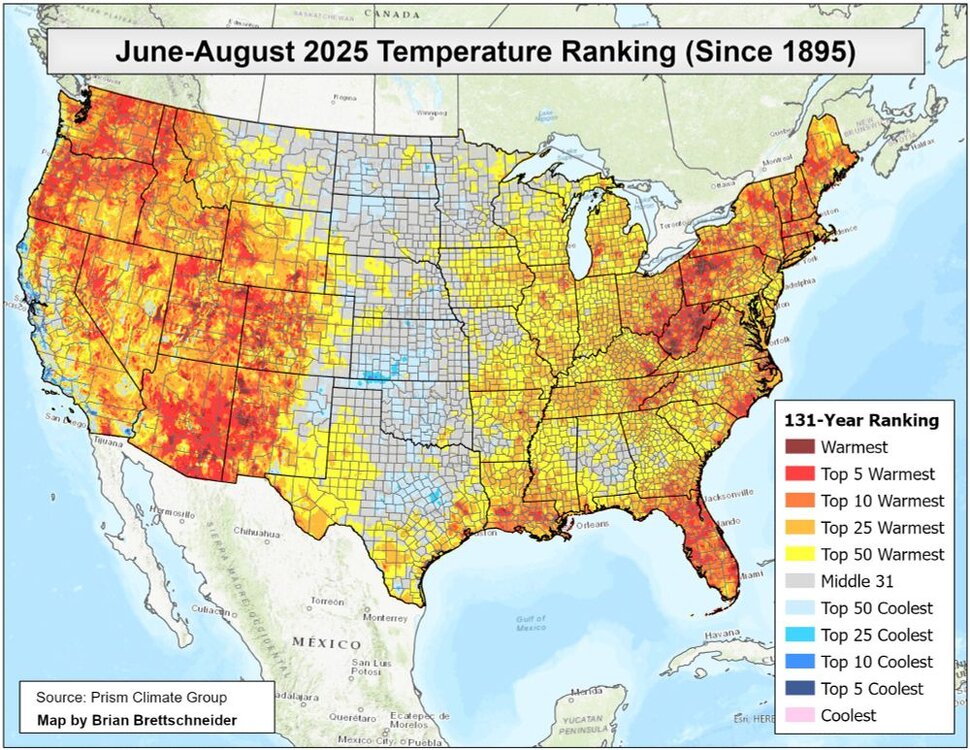
It comes out before the NOAA maps but has been reasonably close based on recent experience to what the NOAA updates have been. The state of PA had their 3rd warmest June and July period on record at 71.8°. The summer ranking will be lower when NCEI updates in a few weeks since August was cooler.
- Today
-

Sunday 1/19 Eagles Game Snow and Stuff
louise.caison233 replied to Ralph Wiggum's topic in Philadelphia Region
I totally agree. Models trending drier are concerning, but sometimes surprises happen. Fingers crossed Berks sneaks into heavier bands tonight. -
Looking forward to a return of the ever evasive southerly flow…it’s way too dry rn. Allergies have been cranking, too. Might as well live in the desert and get desert scenery. Looks like the dry conditions are showing on the drought monitor again as well.
-
Hints of early color up at cabin and on way home yesterday. Thought it early, but maples show first signs of fall usually in early september around home.....and its early september.
-
Yea, normally September is so exciting....
-
6.32" JJA total here.
-
According to Harrisburg Capital Airport, that's been open in the same location and collecting data since 1939, this summer was -.7F.
-
That map, though maybe close and maybe not, is not completely accurate per the map creator. https://prism.oregonstate.edu/historical/ They even state: Values prior to 1981 are based on less extensive observations.
-
Our feeders are filled too, fascinating birds, I love watching them.
-
Just to add to the August climate summary, MU came in BN for the month for temps and it was tied for the driest August on record.
-

September 2025 OBS-Discussion centered NYC subforum
bluewave replied to wdrag's topic in New York City Metro
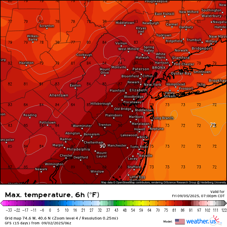
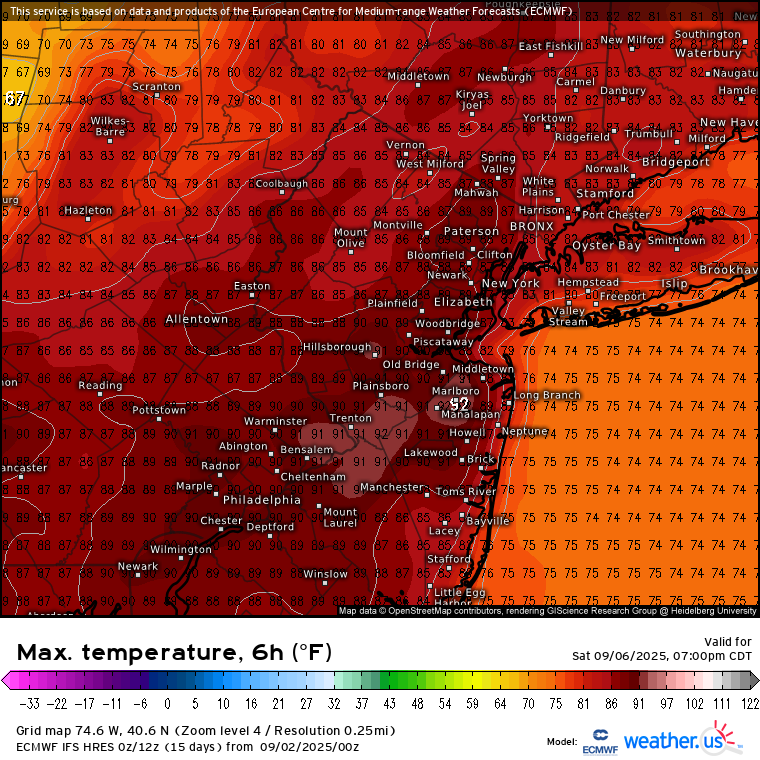
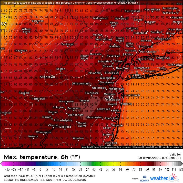
It will probably come down to frontal timing. The GFS has 90° on Friday for the warm spots in NJ. The Euro has a slightly slower frontal passage so the 90° on Saturday. Won’t take much to beat guidance by a few degrees with how dry it has been.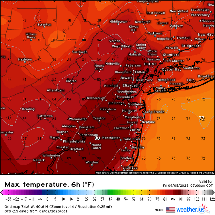
-
My 1.32" for August looks a lot better than your total, but the JJA total here was only 5.29", driest by nearly 2". (POR only 28 years) Curling leaves, bit of early color outside of the swamps, some leaf drop.
-
The August maps won’t update for several more days on that site. But the summer maps on some other sites that have updated are the same pattern. Warm in the East and West with cooler in the middle. The prism maps already updated for JJA with numerous top 10 warmest summer rankings for the Northeast.