All Activity
- Past hour
-
If your whole area is covered in concrete, then why would concrete be a problem for your thermometer? The whole point of a thermometer is to give you an accurate representation of the temperatures you are going to experience.
-
Flood Watch National Weather Service Baltimore MD/Washington DC 1201 PM EDT Wed Jun 18 2025 DCZ001-MDZ004>006-011-013-014-016-503>508-VAZ053-054-505-506-526-527- 190000- /O.NEW.KLWX.FA.A.0016.250618T1700Z-250619T0000Z/ /00000.0.ER.000000T0000Z.000000T0000Z.000000T0000Z.OO/ District of Columbia-Frederick MD-Carroll-Northern Baltimore- Southern Baltimore-Prince Georges-Anne Arundel-Charles-Northwest Montgomery-Central and Southeast Montgomery-Northwest Howard- Central and Southeast Howard-Northwest Harford-Southeast Harford- Fairfax-Arlington/Falls Church/Alexandria-Western Loudoun-Eastern Loudoun-Northwest Prince William-Central and Southeast Prince William/Manassas/Manassas Park- 1201 PM EDT Wed Jun 18 2025 ...FLOOD WATCH IN EFFECT UNTIL 8 PM EDT THIS EVENING... * WHAT...Flash flooding caused by excessive rainfall is possible. * WHERE...Including the following , District of Columbia, in Maryland, Anne Arundel, Carroll, Central and Southeast Howard, Central and Southeast Montgomery, Charles, Frederick MD, Northern Baltimore, Northwest Harford, Northwest Howard, Northwest Montgomery, Prince Georges, Southeast Harford and Southern Baltimore, in Virginia, Arlington/Falls Church/Alexandria, Central and Southeast Prince William/Manassas/Manassas Park, Eastern Loudoun, Fairfax, Northwest Prince William and Western Loudoun. * WHEN...Until 8 PM EDT this evening. * IMPACTS...Excessive runoff may result in flooding of rivers, creeks, streams, and other low-lying and flood-prone locations. * ADDITIONAL DETAILS... - Showers and thunderstorms are likely this afternoon through early this evening. Some thunderstorms will produce heavy rainfall with amounts around 1 to 2 inches within an hour. Localized amounts up to 3 inches are possible in the strongest storms. The heavy amounts of rain in a short period of time may lead to rapid rises of creeks and streams out of their banks as well as potential flash flooding in urban areas. - Please visit www.weather.gov/safety/flood for flood safety and preparedness information PRECAUTIONARY/PREPAREDNESS ACTIONS... You should monitor later forecasts and be prepared to take action should Flash Flood Warnings be issued. &&
-
Borrowed from @WxWatcher007
-
Yeah some guidance is nailing the PHL-NYC corridor. Decent height falls there as mid level temps cool slightly after 18z. I'll enjoy the cirrus.
-
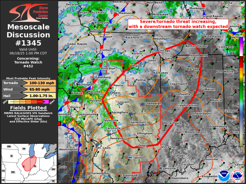
Mesoscale Discussion 1345 NWS Storm Prediction Center Norman OK 1057 AM CDT Wed Jun 18 2025 Areas affected...eastern IL...western/northern IN...far southwest Lower MI Concerning...Tornado Watch 432... Valid 181557Z - 181800Z The severe weather threat for Tornado Watch 432 continues. SUMMARY...Severe threat should increase substantially through mid-afternoon as an arc of storms intensifies to the east-northeast from central Illinois. A few tornadoes, scattered damaging winds, and isolated severe hail will remain possible. Downstream tornado watch issuance is anticipated to the northeast of Ww 432. DISCUSSION...While the primary surface cyclone and attendant MCV are centered near the northeast MO/west-central IL border area, a downstream arc of increasing deep convection is expected to strengthen across central IL. With mid 70s surface dew points common across southern IL/IN, a pronounced MLCAPE gradient is setting up from south to north. A compact belt of strong 700-500 mb southwesterlies in the LSX VWP, recently sampled by the ILX VWP as well, should support a broken band of supercells within this leading arc as it spreads northeast. The potential for tornadoes has increased and a 10 percent tornado probability will be added in the 1630Z D1 Outlook. The LSX VWP also indicates low-level SRH diminishing behind this leading arc, but some tornado threat should linger near the immediate MCV/surface low. ..Grams/Hart.. 06/18/2025 ...Please see www.spc.noaa.gov for graphic product... ATTN...WFO...IWX...GRR...IND...LOT...ILX...LSX...DVN...
-
For the weenies among us
-
Plenty of 75° to 77° dewpoints east of I-95 today.
-
I'm 100% convinced even in an open area it wouldn't be as hot as it was during the 30s-50s period. Why? Because the dryness of the ground matters more.
-
parasitic vines and weeds are overgrowing and I'm going to have to nuke everything this weekend.
-
71/68. Should hit upper 70s I think.
-
it still doesn't explain the extreme heat we had during the 30s to 50s period as well as a drier climate does.
-
Product: Air Force Vortex Message (URPN12 KNHC)Transmitted: 18th day of the month at 15:50ZAgency: United States Air ForceAircraft: Lockheed WC-130J Hercules with reg. number AF97-5306Storm Name: ErickStorm Number & Year: 05 in 2025 (flight in the Northeast Pacific basin)Mission Number: 1Observation Number: 03 ( See all messages of this type for this mission. )A. Time of Center Fix: 18th day of the month at 15:23:50ZB. Center Fix Coordinates: 14.05N 95.98WB. Center Fix Location: 156 statute miles (252 km) to the SSW (199°) from Salina Cruz, Oaxaca, Mexico.C. Minimum Height at Standard Level: 2,915m (9,564ft) at 700mbD. Minimum Sea Level Pressure: 977mb (28.85 inHg)E. Dropsonde Surface Wind at Center: From 310° at 8kts (From the NW at 9mph)F. Eye Character: ClosedG. Eye Shape & Diameter: Circular with a diameter of 20 nautical miles (23 statute miles)H. Estimated (by SFMR or visually) Maximum Surface Wind Inbound: 55kts (63.3mph)I. Location & Time of the Estimated Maximum Surface Wind Inbound: 12 nautical miles (14 statute miles) to the SSE (152°) of center fix at 15:20:30ZJ. Maximum Flight Level Wind Inbound: From 239° at 59kts (From the WSW at 67.9mph)K. Location & Time of the Maximum Flight Level Wind Inbound: 14 nautical miles (16 statute miles) to the SSE (151°) of center fix at 15:20:00ZL. Estimated (by SFMR or visually) Maximum Surface Wind Outbound: 70kts (80.6mph)M. Location & Time of the Estimated Maximum Surface Wind Outbound: 7 nautical miles to the NNW (329°) of center fix at 15:26:00ZN. Maximum Flight Level Wind Outbound: From 50° at 76kts (From the NE at 87.5mph)O. Location & Time of the Maximum Flight Level Wind Outbound: 8 nautical miles to the NW/NNW (326°) of center fix at 15:26:30ZP. Maximum Flight Level Temp & Pressure Altitude Outside Eye: 11°C (52°F) at a pressure alt. of 3,048m (10,000ft)Q. Maximum Flight Level Temp & Pressure Altitude Inside Eye: 14°C (57°F) at a pressure alt. of 3,047m (9,997ft)R. Dewpoint Temp (collected at same location as temp inside eye): 0°C (32°F)R. Sea Surface Temp (collected at same location as temp inside eye): Not AvailableS. Fix Determined By: Penetration, Radar, Wind, Pressure and TemperatureS. Fix Level: 700mbT. Navigational Fix Accuracy: 0.02 nautical milesT. Meteorological Accuracy: 1.5 nautical milesRemarks Section: Maximum Flight Level Wind: 76kts (~ 87.5mph) which was observed 8 nautical miles to the NW/NNW (326°) from the flight level center at 15:26:30Z
-
Higher dew points actually make it more difficult for the temperature to rise as quickly,. the air takes on the physical properties of water.
-

2025-2026 ENSO
TheClimateChanger replied to 40/70 Benchmark's topic in Weather Forecasting and Discussion
Wow, I was going through some old weather records. I know @michsnowfreakreally likes to talk about old heat records, but he seldom mentions the old cold records, including a low of 20F on July 1, 1903, at Wetmore and Baraga (both in the Upper Peninsula of Michigan). I was looking at the Wetmore (near Munising) observations for that month, and wow, I want this injected in my veins. This is incredibly beautiful weather for the month of July, with 4 of the first 5 nights at or below freezing. A mean high temperature of 64.4F, and a mean low temperature of 42.3F. Doesn't get much comfier than that. -
Nope, but I'm not convinced that measuring in a concrete environment gives scientifically comparable results. And it's far more scientifically reasonable to assume that the rainier climate is keeping the maxes from rising as much as the mins are. Climate change means different things for different places and obviously affects summer much more differently than winter. No reason for alarmist talk of widespread 100+ numbers which obviously aren't happening.
-
https://www.spc.noaa.gov/products/md/md1344.html Mesoscale Discussion 1344 NWS Storm Prediction Center Norman OK 1036 AM CDT Wed Jun 18 2025 Areas affected...parts of the Mid-Atlantic States Concerning...Severe potential...Watch possible Valid 181536Z - 181730Z Probability of Watch Issuance...40 percent SUMMARY...The threat for damaging winds should increase this afternoon as isolated to scattered thunderstorms form off parts of the Blue Ridge towards coastal New Jersey and Delaware. Area is being monitored for a possible Severe Thunderstorm Watch with uncertainty on overall coverage/intensity for severe gusts. An upgrade to Slight Risk is likely with the 1630Z Day 1 Outlook. DISCUSSION...Initial low-topped convection has been slowly bubbling across far northern VA and the eastern WV Panhandle. Airmass immediately downstream appears uncapped per mesoanalysis and modified 12Z soundings, where surface temperatures have warmed into the low to mid 80s. 12Z guidance is consistent in suggesting isolated to scattered thunderstorms developing within a region of enhanced 700-500 mb west-southwesterlies. This should provide sufficient speed shear for a few transient cells with mid-level rotation. With poor mid-level lapse rates, hail magnitudes should remain small. But if stratus across the northern Chesapeake/Delaware Bays vicinity can break up this afternoon, a greater than isolated damaging wind threat may be realized. ..Grams/Hart.. 06/18/2025 ...Please see www.spc.noaa.gov for graphic product... ATTN...WFO...PHI...AKQ...CTP...LWX... LAT...LON 39067797 39677750 40097619 40037514 39707417 39247463 38967537 38627599 38577660 38597727 38767779 39067797 MOST PROBABLE PEAK WIND GUST...55-70 MPH MOST PROBABLE PEAK HAIL SIZE...UP TO 1.25 IN
- 1,045 replies
-
- 1
-

-
- severe
- thunderstorms
- (and 2 more)
-
Full Sun, humid. Could be a chance to mow later
-
saved me. Even now it's trying to brighten and just a passing sprinkle earlier. Just cloudy and meh now.
-
Yesterday and today have been rainy and/or drizzly here. Helping the lawn and skeeters We cook tomorrow.
-

2025-2026 ENSO
40/70 Benchmark replied to 40/70 Benchmark's topic in Weather Forecasting and Discussion
Its a general warming....I'm sure the warming varies from staton to station, but everywhere is inarguably warming. -
It was partly sunny here until 2. Then after 3 off and on showers. Not one drop fell prior. You're depressing AF.
-
We got dews 75-80 area wide. Really soupy! Kind of loving it though did a workout outside I was soaked.
-
2025-2026 ENSO
TheClimateChanger replied to 40/70 Benchmark's topic in Weather Forecasting and Discussion
Yeah, and so? At Pittsburgh, there have only been two months since June 2023 that have been colder than normal (January and May 2025 - the latter took until the 31st to eek below the average). -
I think I may actually be seeing a shadow here in Garwood NJ???
-
We've been getting basically average Rainfall at my location. Everything is alive and green. I do worry that if a dry spell comes along it could be a bit problematic here. Areas all around have received abundant Rainfall so, no worries for the area as a whole.


