All Activity
- Past hour
-
Clipper
-
Thats a top 10 snowy month of the past 50 years here.
-

Ice Ice Baby December 28-29 Storm Discussion
TheMainer replied to Baroclinic Zone's topic in New England
Looks like we haven't lost much pack here at all, but currently sitting stopped 10 mins from the house for a log truck rollover cleanup, hoping things will clear shortly since it's 30 mins around...33 and rain still, hoping we Dryslot or flip here soon -

Ice Ice Baby December 28-29 Storm Discussion
CoastalWx replied to Baroclinic Zone's topic in New England
I don’t know, it’s a weird narrow LLJ. But I think most spots still rip. But 3K NAM and HRRR have a similar look if you plot the 850 winds. -

January 2026 Medium/Long Range Discussion
nw baltimore wx replied to snowfan's topic in Mid Atlantic
Right?!? I mean, a 10 day map always has me invested. -
Yea the gefs has it cmc earlier an the euro AI it but it's offshore
-

Ice Ice Baby December 28-29 Storm Discussion
Damage In Tolland replied to Baroclinic Zone's topic in New England
Does that mean meh everywhere else? That seems odd - Yesterday
-

January 2026 regional war/obs/disco thread
WinterWolf replied to Baroclinic Zone's topic in New England
Wouldn’t that look provide some cross polar flow? Or am I looking at it wrong? -
I’m at the point where I think there will be a major east coast storm between the 7th and 10th. It remains to be seen on who misses out. I think the mid-Atlantic north will be particularly favored this first time but idk. We could get a stout HP and get hammered as well. The -NAO just continues to impress on the models. Odds of getting that damming high are up from normal.
-
I also think the 8th is starting to be a trackable window. No guarantees, but it is showing up across modeling and at 500 on ensembles. With the NAO block likely in place, it is certainly a realistic option.
-

Central PA Winter 25/26 Discussion and Obs
mahantango#1 replied to MAG5035's topic in Upstate New York/Pennsylvania
Had a gust of 46 this afternoon. -

Ice Ice Baby December 28-29 Storm Discussion
LSC97wxnut replied to Baroclinic Zone's topic in New England
Huh... Have some pingers. 41.8* -
Kind of a minor event possible on NYD from the Plateau into SE KY, SW VA, and border areas of NE TN. Maybe we can cook something up per the 18z RGEM. I don't think anything more than a dusting or snow showers, but we have seen these trend south at the very last minute - as in the radar is the only thing that verified this far south.
-
One uptrend I’ve seen today is that the ensembles have thrown some haymakers in individual runs. Plenty of duds but some insane runs mixed in as well. Goes to show just how high ceiling *could* be. The southern jet cranking really opens the door for some bombs.
-
why do you post these deflating maps? Can we enjoy something for a few hours?
-
Ice Ice Baby December 28-29 Storm Discussion
CoastalWx replied to Baroclinic Zone's topic in New England
Models have a hell of a LLJ going rulight down rt 2 into BOS. Kind of a weird weenie look with another in wrn CT. Top of the boundary layer at ORH is over 60kts. -
The 9th? Are any other models or runs supporting this look yet?
-
Another clipper type system? Unless those get energized when they hit the coast, precip is going to be on the light side as they have no moisture to work with. From what I saw on the models southern jet is cut off from the northern one, so no sytems diving south to pick up GoM moisture, then coming up the coast for a wallop.
-
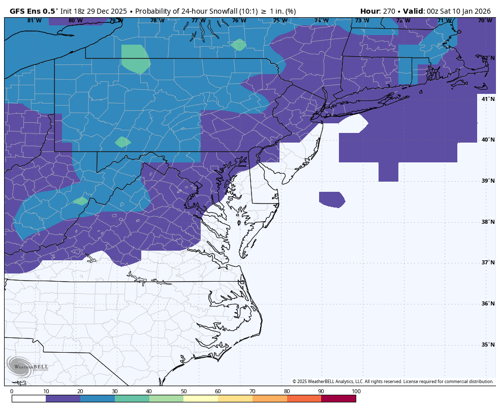
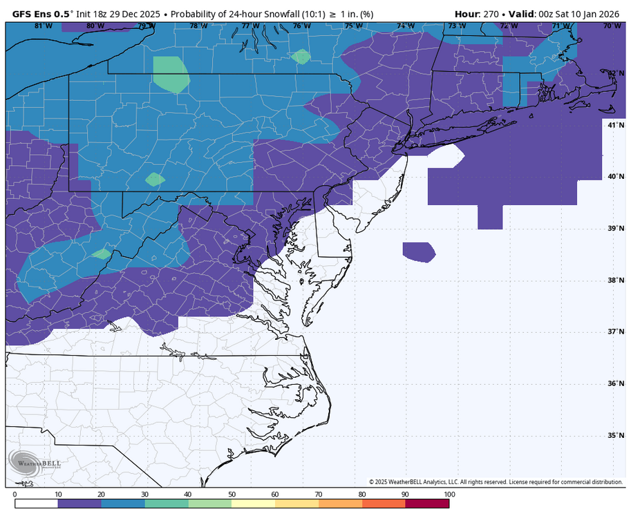
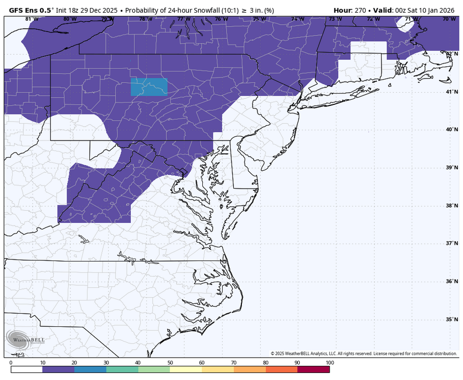
WB 18Z GEFS for Day 10.
-

Ice Ice Baby December 28-29 Storm Discussion
kdxken replied to Baroclinic Zone's topic in New England
Wear your wool knickers. -
Can't wait to hear we lost 20" at about 1130 tonight.
-
Felt like living in lower Michigan today with mood flakes from sunup to sundown. Don't see that very often around here.
-
January 2026 regional war/obs/disco thread
WinterWolf replied to Baroclinic Zone's topic in New England
Lol…thanks. -

Ice Ice Baby December 28-29 Storm Discussion
DavisStraight replied to Baroclinic Zone's topic in New England
I used to bartend there when I was in school, you have it at the Bullard Tavern? -
Ralph just go full on weenie, LFG