All Activity
- Past hour
-

2025-2026 ENSO
PhiEaglesfan712 replied to 40/70 Benchmark's topic in Weather Forecasting and Discussion
Yeah, that one had a very sharp cutoff (like most of the storms that winter). I had to be more north/east for this. 16-17 was almost like 07-08. Yeah, there were some places north that had a good snow season, but south of a certain point, it absolutely sucked. The snowstorm in mid-March made the season toals respectable, otherwise it would have finished right around the 07-08 total. -
It will... But the opportunities will just be less frequent... As for the Aug-Oct trends, are just the reality of our short term climate trends.
-
Certainly much much better than coc k , cool nights and smoke
-
At least we have heat
-
East coast of Bermuda?
-
56.4 for a low this morning, I'm running a -8.6 for the month so far, I'll take it!
-
Looks like MKE finished with 6.69” of rain. More heavy rain moving in - maybe a 10” two-day total?
-
At some point one time before we pass , doesn’t something exciting , damaging , dangerous have to happen with the weather? Does it always have to Stein and hot now in Augdewst - Octorcher ?
-
-
Meh. Good luck.
-
-
Keep feeling it
-
Its coming. Im feeling it this year.
-
Hoping to pull a couple more 90s this week. Get it out of the system and a gradual step down into September
-
 All the models agree on the warm spots starting the heatwave today through Wednesday. Then we get a front coming through on Thursday. But the GFS is the only model with much rainfall so it gets cooler for a few days before the 90s return by next Monday. The Euro and CMC don’t have much rainfall so the Euro brings the heat back faster. The Euro doesn’t dip much below 90° later this week at the NJ warm spots before the heat reloads again by next Sunday or Monday. The issue continues to be lack of rainfall. If we don’t see much rain later this week, then there is nothing stopping the heat from returning again in a week. If we can score some rainfall and cooler temperatures this Thursday and Friday, then we’ll get two separate heatwaves rather than a continuous one at the usual NJ warm spots. But as long as we continue to stay dry, the ridges keep reloading and we keep getting the heat.
 -
We heat this week. All we have since cane gone.
-
"Upper ridge continues to dominate as increasing SW flow brings more humid air into region, but not as oppressive as what we experienced earlier in summer. Additionally, gradient remains weak enough to allow for sea breezes along both coasts Mon and probably Tue as well. Combination of highs in low to mid 90s inland and dewpoints climbing into mid 60s will yield heat index close to 95 degrees, especially Tue, but it still looks marginal at this point in parts of CT and Merrimack Valleys as well as northern RI and interior eastern MA." Meh
-
It’s gonna gain too much latitude. There’s always next year.
-
Nice and cool 54F in Lancaster this morning. .
-
 Ugly AF and equally boring.
 -
The thing I’m mystified at is the proposition that a cold-neutral/borderline La Niña would produce a completely different result than an actual weak La Niña. You are talking about negligible difference in temps. I can’t get my head around that one
-
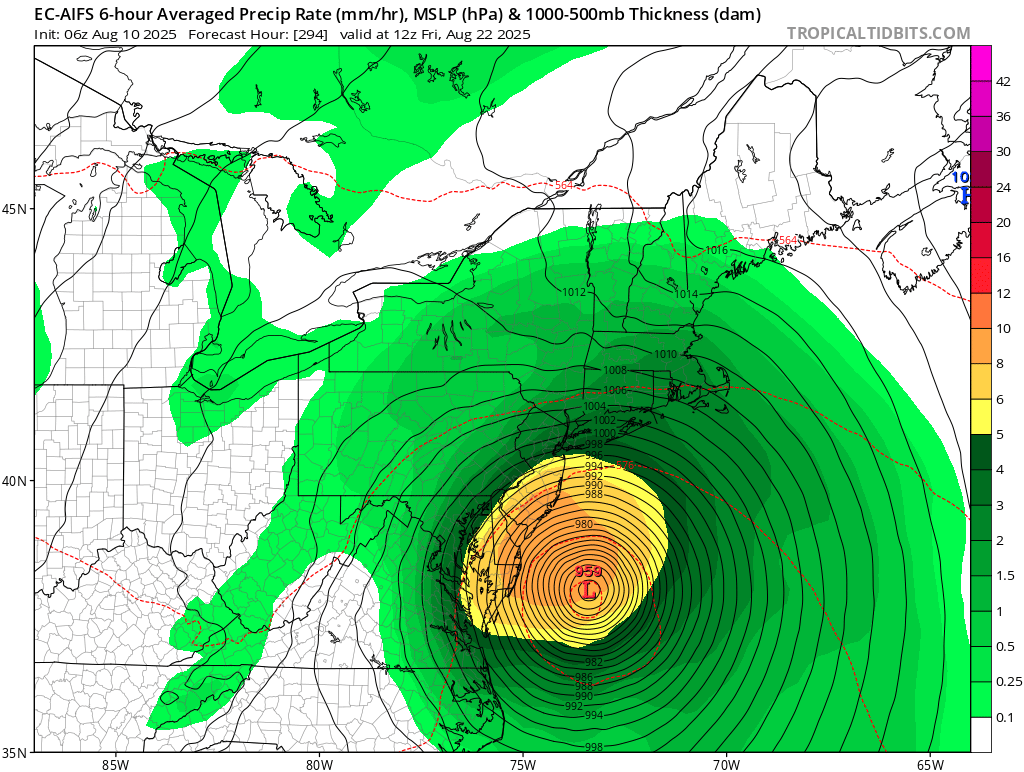
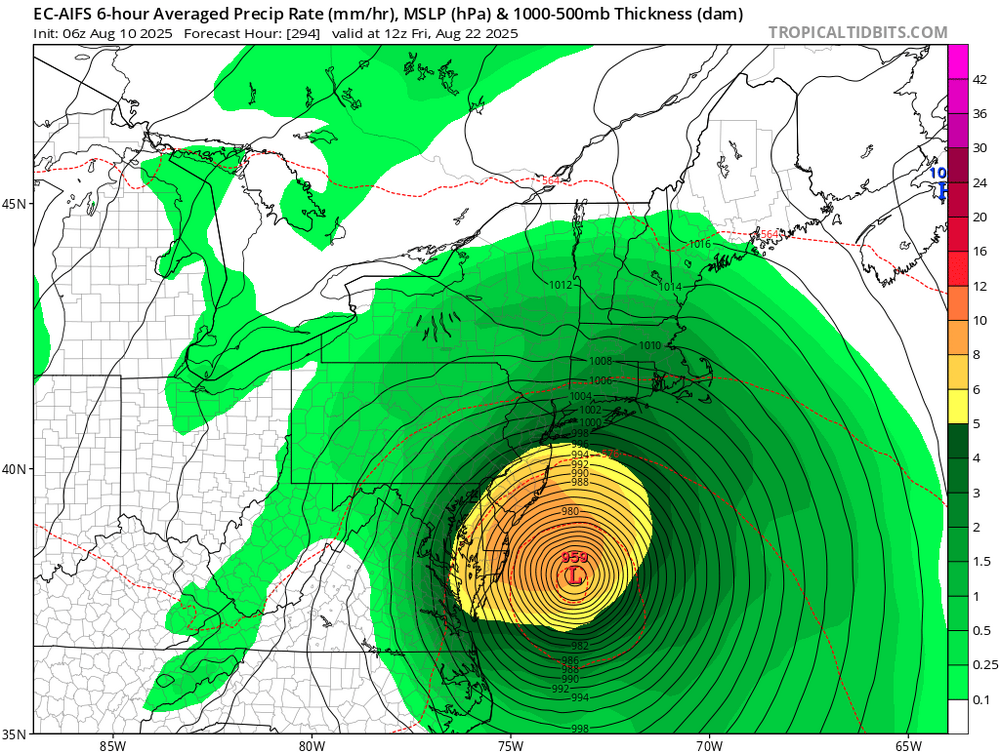
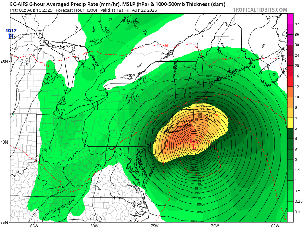
6Z GEFS has many east coast hits
- Today
-
Can we get a “Ain’t happening James”
-
Most of the GEFS are west of the op