All Activity
- Past hour
-
Well you mentioned biases good sir--and believe it or not I'm genuinely curious And have I ever attacked you personally? I mean me ribbing ya a bit on this isn't serious, I promise
-
Radar looks juiced.
-
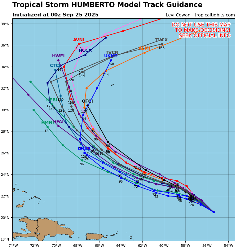
Update: -Season’s ACE is now up to 57.2. -Gabrielle has exceeded earlier progs and is now on its own progged to get ACE to ~60. -Humberto has been declared and is progged to add ACE of ~13 through Sept 30th though with lots of uncertainty, including upside to ~17-20. -That would get ACE to ~73-80. -But that’s not necessarily all as models are now significantly more bullish on still another TC by late this week from Invest 94L. A great level of uncertainty rests with 94L at this very early stage. The upside limit on that through Sept 30 is ~~10. -So, current rough projections are significantly higher for ACE as of Sept 30th. In my quoted prog from 3 days ago, I had the upside at 65-70. That upside limit has since risen to ~83-90. That compares to the 1991-2020 average of 94 through Sept. 30. Thus, if this upside range of 83-90 were to verify, Sept 30th ACE could rise all the way to only a little below the active 30 year average! @snowman19@PhiEaglesfan712
-
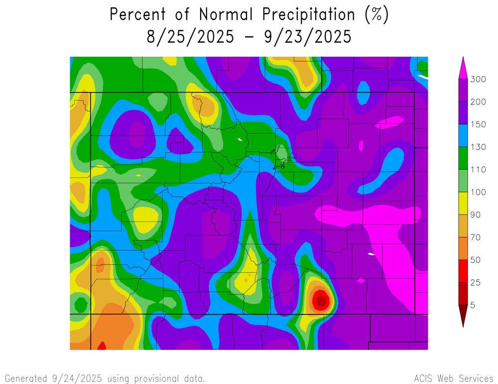
These maps tend to skew dry, but still shows it's been a fairly wet last month for CO.
-
-
Track it with us
-
 FYSA, starting tonight several east coast WFOs will being launching 06z and 18z soundings until further notice.
 -
FYSA, starting tonight several east coast WFOs will being launching 06z and 18z soundings until further notice.
-
Skills
-
nice shift with Humberto with the 0z models

-
Uh, is that the HWRF trying to put 94L to near Cat 3 strength by HR 120?
-
It's the anniversary of Helene, people in the southeast are justifiably on edge.
-
I'm expecting another fairly shitty season for eastern snowfall overall. Recent culprits are not applicable this season though. More generally, for those of you who swear by ONI, the Indian Ocean and Atlantic Ocean are relatively cold at the tropical latitudes, so subtracting out their heat as part of global warming doesn't 'enhance' the R portion of the RONI for La Nina strength as in prior recent years. The cold current by Japan looks it has woken up a bit, and the Atlantic and Indian Ocean are both colder relative to last year than the tropical Pacific. The North/South Pacific are moving toward a +PDO slowly as well with the warm C by the eastern side of the basin showing and the cold tongues showing to the west. Colder tropics overall should mean less MJO relevance in the warm and cold phases, less convection for thunderstorms. High solar is typically a modifier on MJO progression east to west/intensity if you look at it. We also had pretty favorable patterns for sea ice this year, so there should be pretty substantial cold build early on. Last September was pretty cold in Northeast Russia and that cold kept sloshing around until it was forced out of the Arctic in January in a pretty severely cold national pattern for a few weeks. That part of Russia looks pretty cold again this September. I don't consider the AMO/PDO to have flipped this year. But even 'moving' toward opposite phases should reduce the drought tendencies we've seen in the US over the blue areas. You can see last year was close to the exact opposite of figure A (+PDO/-AMO). We should see a much better/wetter winter nationally with the Atlantic much colder and the NE Pacific so much warmer, especially as the cold tongue begins to assert itself by Japan. In the months/seasons with most direct influence from AMO/PDO on precipitation you should see completely different rain/snow patterns to last year. Colder AMO should alter Southeast ridge positioning, independent of the type of La Nina that shows. A lot of the storms that went to bring big rains/snows to KY/TN last year should be east/west of their positions last year, with the PDO hurting KY/TN moisture. My main issue for NE snow is that precip patterns nationally usually have specific signatures nationally in the Summer that have not really shown up for 2025. I think the subtropical jet will not cooperate for eastern storms, even though at times the Northern stream of the jet will go pretty far south this winter.
-
More of the same in the 2020s? No thank you.
- Today
-
92/62 for the day. Warmest day of the month. Just had a small shower roll thru after 17 days of no rain. Dropped a quick 0.19"
-
Next
-

2025-2026 ENSO
brooklynwx99 replied to 40/70 Benchmark's topic in Weather Forecasting and Discussion
in recent years? when has it ever not been tough to maintain a -EPO indefinitely? -
prolonged deluge
-

September 2025 OBS-Discussion centered NYC subforum
Stormlover74 replied to wdrag's topic in New York City Metro
We get noise from takeoffs from ewr but I'm so used to it I don't notice. Occasionally Lufthansa's 747 (the only remaining 747 into ewr) will fly overhead on its descent -
snow season will be here soon enough.. the weather has been so boring so I'm trying to find anything remotely exciting..
-

2025 Atlantic Hurricane Season
Supercane replied to BarryStantonGBP's topic in Tropical Headquarters
Tropical Storm Delta in 2005 is the only Atlantic tropical cyclone on record to reach Africa at any point in its life - in Delta's case, it was as a moderate extratropical cyclone. It also caused significant wind damage to Canary Islands: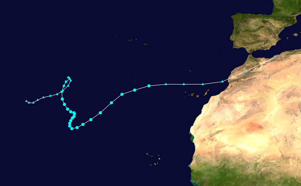
-

2025-2026 Fall/Winter Mountain Thread
Maggie Valley Steve replied to Buckethead's topic in Southeastern States
And there's the first statement from GSP this evening.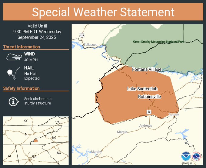
-
I probably had like 80" those seasons....sign me up.
-
You should change your moniker to I need hurricanes.
-

September 2025 OBS-Discussion centered NYC subforum
psv88 replied to wdrag's topic in New York City Metro
81 today. No airplane noise out here. Occasionally a plane from farmingdale I guess, but we aren’t in a flight path. I am a mile from the LIE so I do hear the traffic from time to time which stinks