All Activity
- Past hour
-

2026-2027 Strong/Super El Nino
roardog replied to Stormchaserchuck1's topic in Weather Forecasting and Discussion
So does a Modoki just have to have lower anomalies in 3 and 1+2 than in 3.4 and 4 or does 1+2 need to be negative? I feel like that’s the same scenario just opposite. -

2026-2027 Strong/Super El Nino
GaWx replied to Stormchaserchuck1's topic in Weather Forecasting and Discussion
I’d say no based on past strong+ El Niño anomalies. Nino 4 has been at a minimum +0.5C. The idea is that 3.4 and 4 anomalies are lower than 3 and 1+2 as opposed to needing to be ~0. -

Central PA Summer 2026 Discussion/Obs Thread
mahantango#1 replied to Voyager's topic in Upstate New York/Pennsylvania
79 for the high today. -

2026-2027 Strong/Super El Nino
raindancewx replied to Stormchaserchuck1's topic in Weather Forecasting and Discussion
On the May update, the Euro had Nino 4 getting to 2-2.5C above the 30-year mean in December. That's a huge body of water, and far less volatile than the more eastern areas of the Tropical Pacific. The correlation isn't super strong - but with a very extreme reading, of say 30.5C+ or warmer - never achieved on record - you have to assume we get close to the long-term trend. Your 29.5C+ Decembers are 1994, 2006 (both just under but over 29.4), 2009, 2015, 2018, 2023. Basically dead on to the correlation. Also consistent with Decembers following my hottest 10 Marches of the past 100 years. I'd go 2-4 degrees warmer in the warmer areas and 1-2 degrees colder in the white areas based on the extremity forecast for December. -
 Awww. I love Chuck.
 -
2026-2027 Strong/Super El Nino
roardog replied to Stormchaserchuck1's topic in Weather Forecasting and Discussion
What are your latest thoughts? You’re definitely one of the least biased and more knowledgeable posters here. Always appreciate you giving your thoughts -
Down to 47 here. Sent from my Pixel 10 Pro using Tapatalk
-
Temp down to 53 baby!
- Today
-
There was just some very light rain today (a T). It was windy from the E as cooler, drier air was coming in. With temps down to the mid 70s, the steady breeze, and dewpoints in the mid 50s, it easily felt good enough to walk at the park for the first time in nearly 2 weeks despite a few rain drops.
-
 Persistent NW flow with breaks of southeast ridging are not a good recipe for rain in these parts. The NW flow is the biggest culprit. It's why we've had these incredible spells of nice weather this time of year, but it's a detriment to rain chances due to increased dry air aloft and relevant down sloping potential when winds shift westerly. Need more persistent southwest flow with moisture advection. Haven't gotten into that yet.
 -
2026-2027 Strong/Super El Nino
roardog replied to Stormchaserchuck1's topic in Weather Forecasting and Discussion
A true east based Nino should have near zero or negative anomalies in Nino 4 correct? I’ll believe that when I see it. I believe Nino 4 had a big drop off in June 1997. Let’s see if that happens this year. -
Looking more likely we get the first heat wave of the year Thursday Friday Saturday.
-
-

2026-2027 Strong/Super El Nino
Stormchaserchuck1 replied to Stormchaserchuck1's topic in Weather Forecasting and Discussion
Where's El Nino in the N Pacific? -

2026-2027 Strong/Super El Nino
so_whats_happening replied to Stormchaserchuck1's topic in Weather Forecasting and Discussion
Just a cesspool like twitter in here, bunch of noise with very little thought. I'll remove April in future updates..thumb.gif.960ed0184b33989049424223a22b6de3.gif)
-
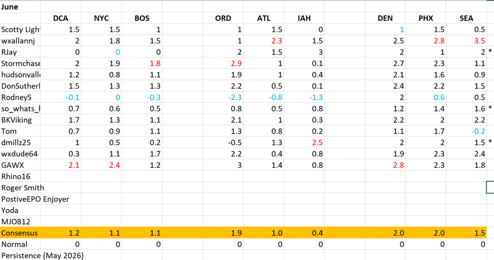
Asterik indicate slight point deduction with late entries. This was the first time it has happened so i'll keep it lenient (I also was late). Going forward I will still send a reminder the day before entry is done and we will go from there. Good luck in June!
-
I just don't really want to do hottest day contest. Thanks for asking though
-
Today was colder than Christmas 2015.
- Yesterday
-
No worries we will keep it just a small deduction (barely noticeable), the date snuck up on me as well.
-
More rain this evening with a current temp of 56 degrees already.
-
This morning was unseasonably cool. It may well go on to be the coolest morning of the summer. Lows included: Atlantic City: 45° Bridgeport: 48° Islip: 46° New York City-Central Park: 52° New York City-JFK Airport: 50° (old record: 51°, 1997, 2003, 2015) New York City-LaGuardia Airport: 55° Newark: 51° Philadelphia: 53° Poughkeepsie: 41° Westhampton: 35° (old record: 39°, 2020) White Plains: 46° (old record: 47°, 1971, 1984, 1988, 1993) A warming trend will commence tomorrow with highs in the upper 70s to perhaps lower 80s. Thursday should see temperatures top out in lower 80s. Friday and Saturday will be very warm days with highs in the upper 80s and lower 90s. Saturday will remain warm before somewhat cooler air arrives to conclude the weekend. The ENSO Region 1+2 anomaly was +2.2°C and the Region 3.4 anomaly was +1.0°C for the week centered around May 27. For the past six weeks, the ENSO Region 1+2 anomaly has averaged +1.80°C and the ENSO Region 3.4 anomaly has averaged +0.90°C. The ongoing El Niño will continue to strengthen through the summer. The SOI was -16.87 yesterday. The preliminary Arctic Oscillation (AO) was +0.714 today.
-
 Hopefully something pops up. Some afternoon strong thunderstorms would be nice. It's been a real snoozer since Sleet fest.
 -

2026-2027 Strong/Super El Nino
FPizz replied to Stormchaserchuck1's topic in Weather Forecasting and Discussion
What was the total precip that winter in central park? I remember the crappy winter snow wise (5.5" total here) but cant remember if it was wet too. -
Good question. Notice the amount of clouds in the sky on an average day. The last few days it was better, but we were really clear in May. A few years ago in February 24/28 were completely clear skies. We are veering towards less precip patterns in the last few years.


.gif.30cd6a84e8bd5913945d7bc78961a9b3.gif)


