All Activity
- Past hour
-

E PA/NJ/DE Winter 2025-26 Obs/Discussion
Ralph Wiggum replied to LVblizzard's topic in Philadelphia Region
Paging @donsutherland1 -
E PA/NJ/DE Winter 2025-26 Obs/Discussion
Ralph Wiggum replied to LVblizzard's topic in Philadelphia Region
Whether or not we get a storm, I still consider this stretch rather historic, not "wasted". -

Possible coastal storm centered on Feb 1 2026.
CoastalWx replied to Typhoon Tip's topic in New England
6z gfs laughs at 00z. She gone. -

February 2026 Medium/ Long Range Discussion: Buckle Up!
stormtracker replied to Weather Will's topic in Mid Atlantic
Insomnia got the best of me..back up. lol GFS looks more like Euro. Of course it does. But this time it's positive. This seems to be trended a bit better with each run. 3-5 It's a decent snowfall, with heavier stuff staying to our.....take a guess. -
Be a man. If you say something, stick with it. Do your time. You promised you'd leave for two weeks. Do it. No one around here will respect you if you stay.
-

Richmond Metro/Hampton Roads Area Discussion
eaglesin2011 replied to RIC Airport's topic in Mid Atlantic
The models are all over the place because they can’t figure out how& where the storm will develop off the coast & how much dry air will get into this storm (from two directions) .. It’s definitely going to be boom or bust in many areas… If your in VA beach through Richmond area, that last NAM run is pretty much exactly what we need to happen to really get a nice hit in both places.It forms exactly where we need it to & pushes moisture back into both areas perfectly… -

Arctic Hounds Unleashed: Long Duration Late January Cold Snap
kdxken replied to WxWatcher007's topic in New England

-
Arctic Hounds Unleashed: Long Duration Late January Cold Snap
kdxken replied to WxWatcher007's topic in New England
So when do we run out of fuel?
-

Arctic Hounds Unleashed: Long Duration Late January Cold Snap
ineedsnow replied to WxWatcher007's topic in New England
Got down to 1 at home so far.. very meh compared to yesterday -
Clueless. You contribute nothing to this forum besides being a troll. Never have. I challenge everyone to go look back on all of your posts and find anything at all meaningful and productive you’ve posted. A completely useless, worthless member. You’re also not very smart. And I love how @brooklynwx99 put a laughing emoji on your post. Probably the worst weenie meteorologist I’ve ever read in my life. He shouldn’t be laughing at anyone after all of his epic busts since the 21-22 winter. I’ve lost track. Constantly predicting historic, best pattern ever, textbook, guaranteed KU coastal snowstorm patterns, which DC-PHL-NYC hasn’t seen since February, 2021. Dreadful. Always hyping snowstorms just like JB
-

1-30/2-1-26 Arctic Blast, ULL Snow Event
Uncle Nasty replied to John1122's topic in Tennessee Valley
Locals aren't impressed. Mostly to our east with a dusting in Chatty. Snow mainly Cleveland and east. Sent from my SM-S916U using Tapatalk -

The “I bring the mojo” Jan 30-Feb 1 potential winter storm
ncforecaster89 replied to lilj4425's topic in Southeastern States
It’s a direct consequence of the more eastward track and finding ourselves in the strong subsidence zone, while the more inland areas are in the deformation zone. There’s always going to be winners and losers in these type of setups…with a coastal low that’s bombing. In this particular run/solution, we are the undisputed losers. But like Josh noted, it’s still too early to pinpoint the precise location of these dynamics.
-

Richmond Metro/Hampton Roads Area Discussion
overcautionisbad replied to RIC Airport's topic in Mid Atlantic
Possible. It's going to whatever it does models or not. In fact models are so all over the place I'm not sure anyone will be certain until its happening It would be funny if Richmond ended up with 9 inches of snow and TV mets had to get on tv and explain why they forecasted 2 inches. Wouldn't be the first time. Lol Doubt it happens like that. The realist in me says like 3 or 4 for me in Chesterfield. Possibly nothing. But also possibly 9 I guess. I'd give nothing higher odds than 9 I suppose -

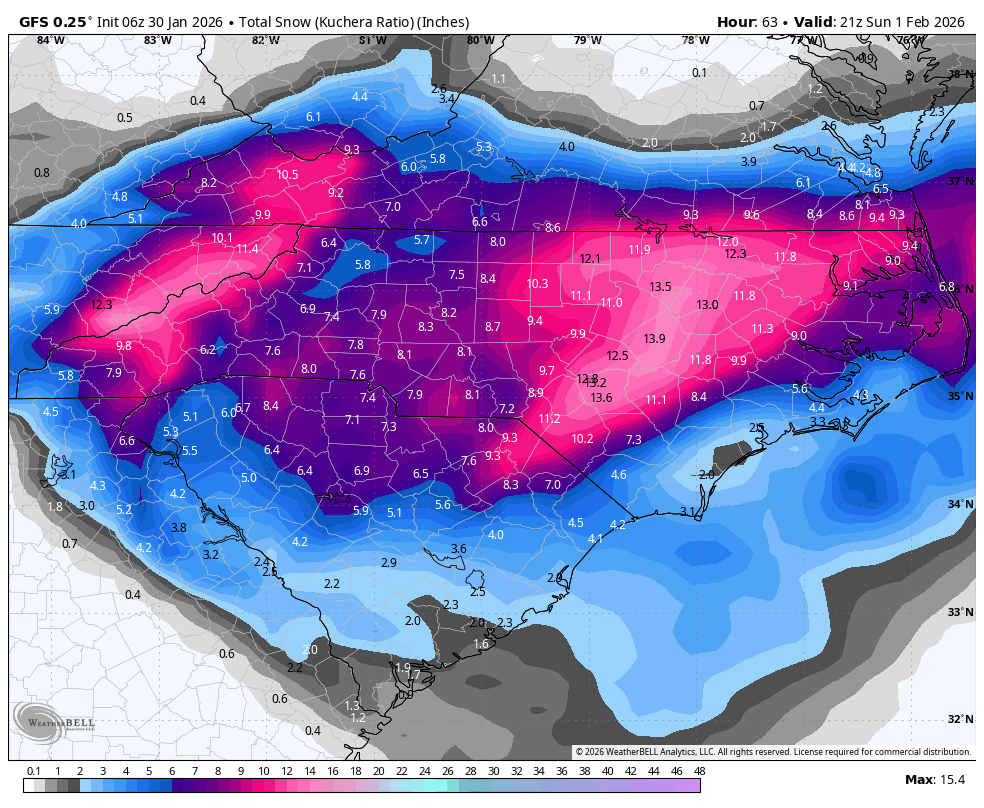
The “I bring the mojo” Jan 30-Feb 1 potential winter storm
lilj4425 replied to lilj4425's topic in Southeastern States
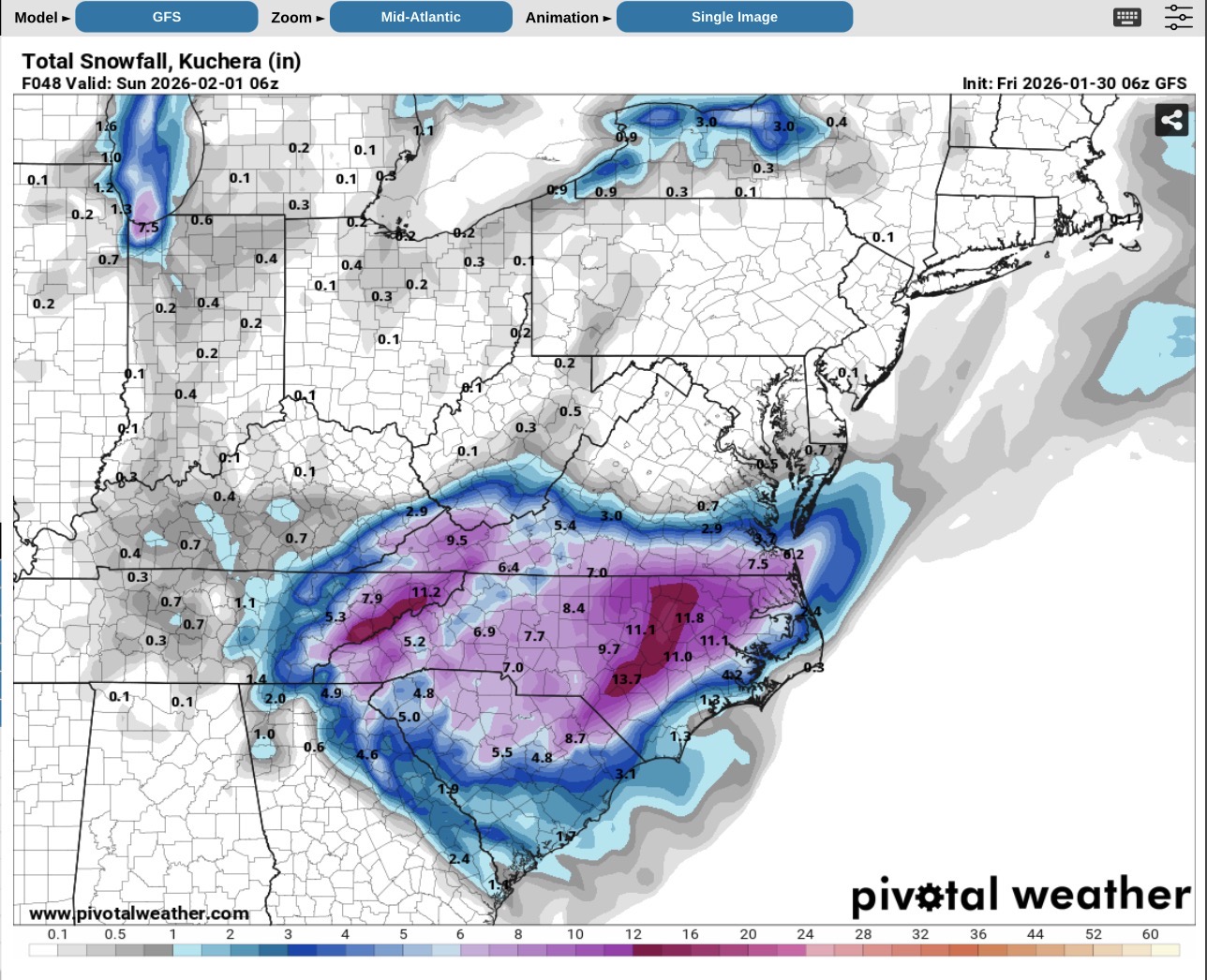
Models all over the damn place still. I’m everywhere from a dusting (NAM) to almost ten inches (Euro) depending on which one you look at. lol. -

The “I bring the mojo” Jan 30-Feb 1 potential winter storm
senc30 replied to lilj4425's topic in Southeastern States
Looks like the gfs dropped numbers a lot for the coastal area. -

The “I bring the mojo” Jan 30-Feb 1 potential winter storm
JoshM replied to lilj4425's topic in Southeastern States
Definitely, someone’s going to get screwed by the dry air. But that’s a now cast thing. -
The “I bring the mojo” Jan 30-Feb 1 potential winter storm
JoshM replied to lilj4425's topic in Southeastern States

-
The “I bring the mojo” Jan 30-Feb 1 potential winter storm
JoshM replied to lilj4425's topic in Southeastern States
Looking similar to 0z -
The “I bring the mojo” Jan 30-Feb 1 potential winter storm
JoshM replied to lilj4425's topic in Southeastern States
6z running … steady as she goes thru hour 30 -
-
The “I bring the mojo” Jan 30-Feb 1 potential winter storm
ncforecaster89 replied to lilj4425's topic in Southeastern States
You’re correct in that the NAM is more prone to exaggerated dry slots than the globals (such as the ECMWF and GFS). Even so, the physics still apply and is a definite cause for concern. It was also seen on the 18Z ECMWF, as well. In both cases, the dry slot was directly over my house! -
The “I bring the mojo” Jan 30-Feb 1 potential winter storm
JoshM replied to lilj4425's topic in Southeastern States
Well, the NAM has a bias to overamp these things , so I’m hoping it’s out to lunch for now -
Richmond Metro/Hampton Roads Area Discussion
eaglesin2011 replied to RIC Airport's topic in Mid Atlantic
That Nam run is just about the best run you can have for the RVA & VA Beach area… Everything just backfills perfectly & it’s not north enough to get more dry air pulled into it. Now if it could just actually happen like that .. lol -
NAM and to some extent the Icon there continue to have me spooked, but man have we longed for times like these....
-
1-30/2-1-26 Arctic Blast, ULL Snow Event
Uncle Nasty replied to John1122's topic in Tennessee Valley
I fell asleep before our local 11:00 news last night. The 6 o'clock news had our highs for Friday (now today) at 46°. When (if) the moisture arrives, starting as light rain and then changing to snow when the cold air filters in. Channel 3 has us up to 2". Channel 9 a dusting to 1". Curious what they will be showing in a few minutes with the morning crew. 2" is not much, if we can manage to get that, BUT, with temps in the low to mid 20's for Saturday highs, everything should at least be covered white and stick around a few days. I'd rather have 2" on the ground a few days instead of those 4" snows that melt off within 4 or 5 hours. I'm still skeptical about losing what we might get to virga. Edit to add: our forecast low was 26°. We bottomed out in Ooltewah at 19° and currently sitting at 20°. Sent from my SM-S916U using Tapatalk