All Activity
- Past hour
-
Exactly the same here, 0.40" thru 7 AM and 0.78" 7 AM thru 9 PM. (Another 0.01" of DZ overnight, but that goes in the May bucket.) Month finished at 4.00" - 7th consecutive BN month and 10th of 11, but only by a whisker. April average is 4.06".
-

2026-2027 Strong El Nino
LakePaste25 replied to Stormchaserchuck1's topic in Weather Forecasting and Discussion
The reason many of the big mets on twitter are going with super and east based is because most Ninos that have started out the way this one is starting out have gone that way, so they’re not just doing it because they have some inherent warm bias - they have data to back it up. But the thing about meteorology (and the broader sciences) is that past data is only right until otherwise proven wrong. -

2026-2027 Strong El Nino
GaWx replied to Stormchaserchuck1's topic in Weather Forecasting and Discussion
Thanks. 1. You’re right that 1911-12 was colder in the Great Lakes/Midwest than in the South (see image below). So, good find and makes my statement wrong about ALL moderate or stronger El Niños on record not being colder in the N than in the S. I stand corrected. 2. However, though not as cold, the South still had a pretty cold winter (2-4 BN), which is unlike the NN on the Cansips. So, in that regard, the Cansips is still not making sense to me. 3. By the way, 1911-12 was just a lower end moderate with a peak of +1.2 per Webb rather than strong. But it’s still an exception to my statement since I was referring to moderate or stronger: https://www.webberweather.com/ensemble-oceanic-nino-index.html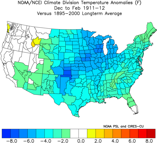
-

2026-2027 Strong El Nino
michsnowfreak replied to Stormchaserchuck1's topic in Weather Forecasting and Discussion
Oh I do too. I take everything with a grain of salt at this stage. I have also said several times that I expect '26-27 winter to be milder here than the past 2. But these automatic assumptions of some torch winter and a super nino- not buying it at this stage. -
2026-2027 Strong El Nino
LakePaste25 replied to Stormchaserchuck1's topic in Weather Forecasting and Discussion
This is where I’m at as well. Until I see a more supportive evidence in the SSTA/MJO/WWB evolution that supports a CANSIPS-like outcome, I’m taking it with a grain of salt. Modelology vs. Meteorology. -
My modelling method would suggest the same probability for our sub. Lots of CAN air intrusion.
-
Had 2.07" this month but 1.5" of that has fallen since 4/27. Only 51% of our normal rainfall for the month.
-
Did I let you know? I honestly forget. I think it was 72.7.
-
Rollercoaster temps for the 1st week of the month here in TH.
-

2026-2027 Strong El Nino
40/70 Benchmark replied to Stormchaserchuck1's topic in Weather Forecasting and Discussion
I have to be honest...I'm taking it with a grain of salt at this stage, too....to be fair to Adam. If it still looks like that in October, then it may be time to take it more seriously. -
2026-2027 Strong El Nino
michsnowfreak replied to Stormchaserchuck1's topic in Weather Forecasting and Discussion
So the model is simultaneously correct in jumping to a stronger Nino, but INCORRECT in staying consistent with a cold winter look in the Great Lakes, similiar to the last 2 winters. Got it. -
May 1 1966: Winter makes a last stab at Minnesota with a low of 5 at Cook. A widespread freeze hits the rest of the state. 1935: An unusually late snow and ice storm hits east central Minnesota. The heaviest ice accumulations are between St. Paul and Forest Lake and westward to Buffalo in Wright County, with accumulations of 1 to 1.5 inches on wires. The downtown Minneapolis weather bureau records 3 inches of snow. For Friday, May 1, 2026 1854 - The Connecticut River reached a level of nearly twenty-nine feet at Hartford (the highest level of record up until that time). The record height was reached in the midst of a great New England flood which followed sixty-six hours of steady rain. (David Ludlum) 1935 - Snow, ice and sleet brought winter back to parts of southeast Minnesota. Minneapolis received three inches of snow to tie their May record which was established in 1892. (1st-2nd) (The Weather Channel) 1954 - The temperature at Polebridge MT dipped to 5 degrees below zero to establish a state record for the month of May. (The Weather Channel) 1987 - Thunderstorms produced large hail and heavy rain in Texas. Baseball size hail pounded Dublin, and 3.75 inches of rain soaked Brady. (The National Weather Summary) (Storm Data) 1988 - Strong southerly winds ahead of a cold front crossing the Rocky Mountain Region gusted to 90 mph at Lamar CO. High winds created blinding dust storms in eastern Colorado, closing roads around Limon. (The National Weather Summary) (Storm Data) 1989 - Thunderstorms produced heavy rain in the southeastern U.S. Rainfall totals of 1.84 inches at Charlotte NC and 2.86 inches at Atlanta GA were records for the date. Strong thunderstorm winds uprooted trees in Twiggs County GA. (The National Weather Summary) (Storm Data) 1990 - Thunderstorms produced severe weather from northern Alabama to North Carolina. There were sixty-three reports of large hail or damaging winds, with hail four inches in diameter reported near Cartersville GA. Ten cities in the southeastern U.S. reported record high temperatures for the date as readings warmed into the 90s. Jacksonville FL reported a record high of 96 degrees. Late night thunderstorms over central Texas produced up to ten inches of rain in southern Kimble County and northern Edwards County. (The National Weather Summary) (Storm Data)
-
2026-2027 Strong El Nino
michsnowfreak replied to Stormchaserchuck1's topic in Weather Forecasting and Discussion
I disagree. While the mean of a strong Nino is a milder than avg winter in the north, keep in mind theres tons of hugging the warmest and/or least wintry Ninos on record in here by some. Thats not how weather always works. The strong El Nino of 1911-12 was a brutally cold winter, one of the coldest on record. It definitely didnt fit the mold of a typical strong Nino. And yes, even back then (before we hear about a different climate) strong Ninos generally produced mild winters, including 1877-78 (year without a winter in the upper midwest) and 1918-19 (a winter far less snowy than any ive ever experience). Using the more common post-1950 list. Moderate are a mixed bag- several cold winters in there. And several of the strong Ninos averaged on the average to cool side of average here. -
Nice morning, I'm enjoying this coolness. You know it'll be in short supply soon.
-
I had ~0.05” yesterday morning, which brought me up to a total of ~1.5” for April, <50% of the normal of ~3.25” but ~double what I got in March (which was almost all on March 8th by the way). The last 1” of the 1.5” was received just since April 26th on 3 different days with most of that (0.8”) falling on 4/26.
-
This looks like a terrific opportunity for Brian to end up under one of those stationary diurnal cloud streets while it's sunny a mi E and W of his immediate neighborhood ?
-
Haven't gone this route yet. I did go soy-free a year or two ago on your rec, and I think it's made a big flock-health difference, so I'm willing to try this.
-

Central PA Spring 2026 Discussion/Obs Thread
Itstrainingtime replied to Voyager's topic in Upstate New York/Pennsylvania
Do I laugh at this, like it, or thank you? I chose none of the above. I couldn't decide. -
Figured this is appropriate given today's date.
-
DLH for April avg temp 37.8 (-1.7),and precip 3.66" (+1.13). TH ended with 6.83" (+4.18) at CoCoRAHS site Two Harbors 2.0 ENE. 6.16" (+3.51") at the TH Co-op (3rd wettest). 2001 pcpn 8.83 1 1 1 0 1894 pcpn 6.71 2 2 2 0 *2026 pcpn 6.16 3 3 3 0 1948 pcpn 5.72 4 4 4 0 1968 pcpn 4.73 5 5 5 0
-
Builders take topsoil??? That should be considered a legitimate crime.
-
Omega 3 time is fun

-

Central PA Spring 2026 Discussion/Obs Thread
Mount Joy Snowman replied to Voyager's topic in Upstate New York/Pennsylvania
Ended up at 56.4, tied for 10th. Two tenths off, I'll strive to be better. -
High of 95 on 4/17, low of 35 on 4/8. 1.74"
-
Never a doomer myself and always laughed at them. Especially the bunker-type (although I still laugh at them - first was on the premise of end-times being near, but now for thinking their efforts will matter (they won't)). Thought it was just mankind being mankind, thinking the end is near. My tune has changed since the Epstein files were released. I always sort of knew capitalism ruled, and 99.9% of people are just a means to the elites end, but never realized the span and depth of their control. People can shout conspiracy, but it's pretty much validated now - democracy isn't real, you are merely a dollar sign, nothing you do or say matters (beyond hyper-locally), and it's top vs. bottom, not left vs. right. But the SS change has sailed. Unless it's a full-scale revolution of the 99% stomping out the 1% - but we're too fat/happy/distracted to pull that off now. The total control/surveillance state is actually here (hi!) after 2+ decades of slowly normalizing it. --- One of the silent issues nobody is talking about is the exponential proliferation of data centers and the economic and environmental impact they'll continue to have. We're rapidly being pushed towards a economic and natural resource crisis that'll result in the total takeover of the 99% - and it'll be done without a single bullet, quite easily. And by the time it happens there will still be people shouting about climate change, and gender identity, and human life being a bad use of tax dollars (while not mentioning the tax dollars that are used to line pockets), and whether or not their favorite public figure is a pedophile.


