All Activity
- Past hour
-
well...I guess this marks the 2nd snow event since this new cold pattern arrived that was completely claimed by dry air.
-
Nice winter chill in the air the past 7 days for you folks out east.
-
Don't overlook tomorrow good March mixing and 50s gusts seems likely
-
Looks very impressive. The other night was just the appetizer.
-
Yeah just looked at the schedule- April 2026. I will be down there in early April- hopefully I can get it on tap.
-
.thumb.jpg.6a4895b2a43f87359e4e7d04a6fa0d14.jpg)
Central PA Spring 2026 Discussion/Obs Thread
Yardstickgozinya replied to Voyager's topic in Upstate New York/Pennsylvania
I think you had an upload error -
Im almost always lurking on the forum,just don't post much. Looks to me like 18z GFS and NAM are pretty similar with a SE shift.
-

Central PA Spring 2026 Discussion/Obs Thread
MAG5035 replied to Voyager's topic in Upstate New York/Pennsylvania
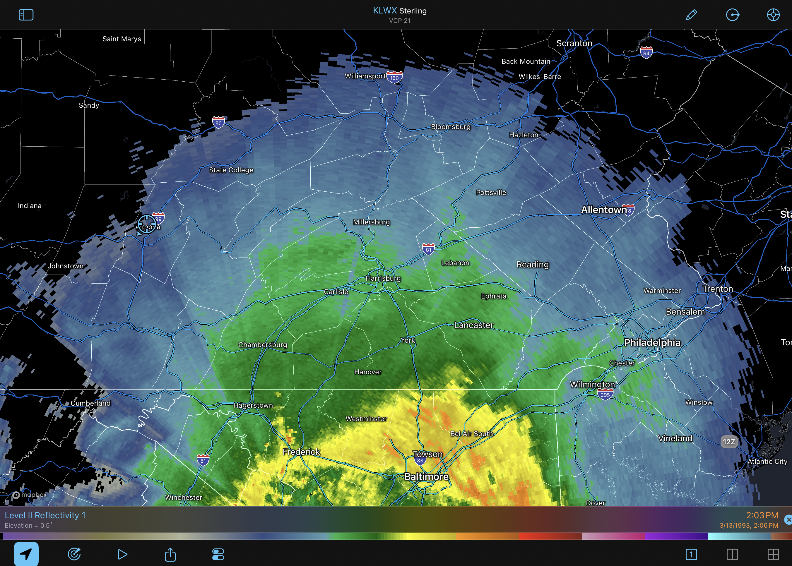
Here’s an archived radar image I could get on board with. Some other March 13th a while back.
-
Is this the newest release? 2026? The latest one is the 'Limited Release' from 2025, which is damn good- might be my favorite.
-
-
Yup. At least for McHenry/Kane and northwest. The city not as much. Baby steps.
-
EPS has us under the cool bubble
-
Just lost power with power lines down all over the county from a massive gust a few minutes ago
-
Gfs slightly better?
-
Thanks for the update snowman19 Monday could be impressive if we get more instability than forecast. A strong squall is likely.
-
That 18Z NAM Solution would have southern MI immediately go from 60s with damaging winds to heavy freezing rain behind the line, brutal
-
Location still isn't bad at all.
-

2026 Mid-Atlantic Severe Storm General Discussion
wxmeddler replied to Kmlwx's topic in Mid Atlantic
Not everyday you get a CONUS wide mid-latitude trough break in the center of the country. Exceptional synoptics call for exceptional caution. -
Central PA Spring 2026 Discussion/Obs Thread
MAG5035 replied to Voyager's topic in Upstate New York/Pennsylvania
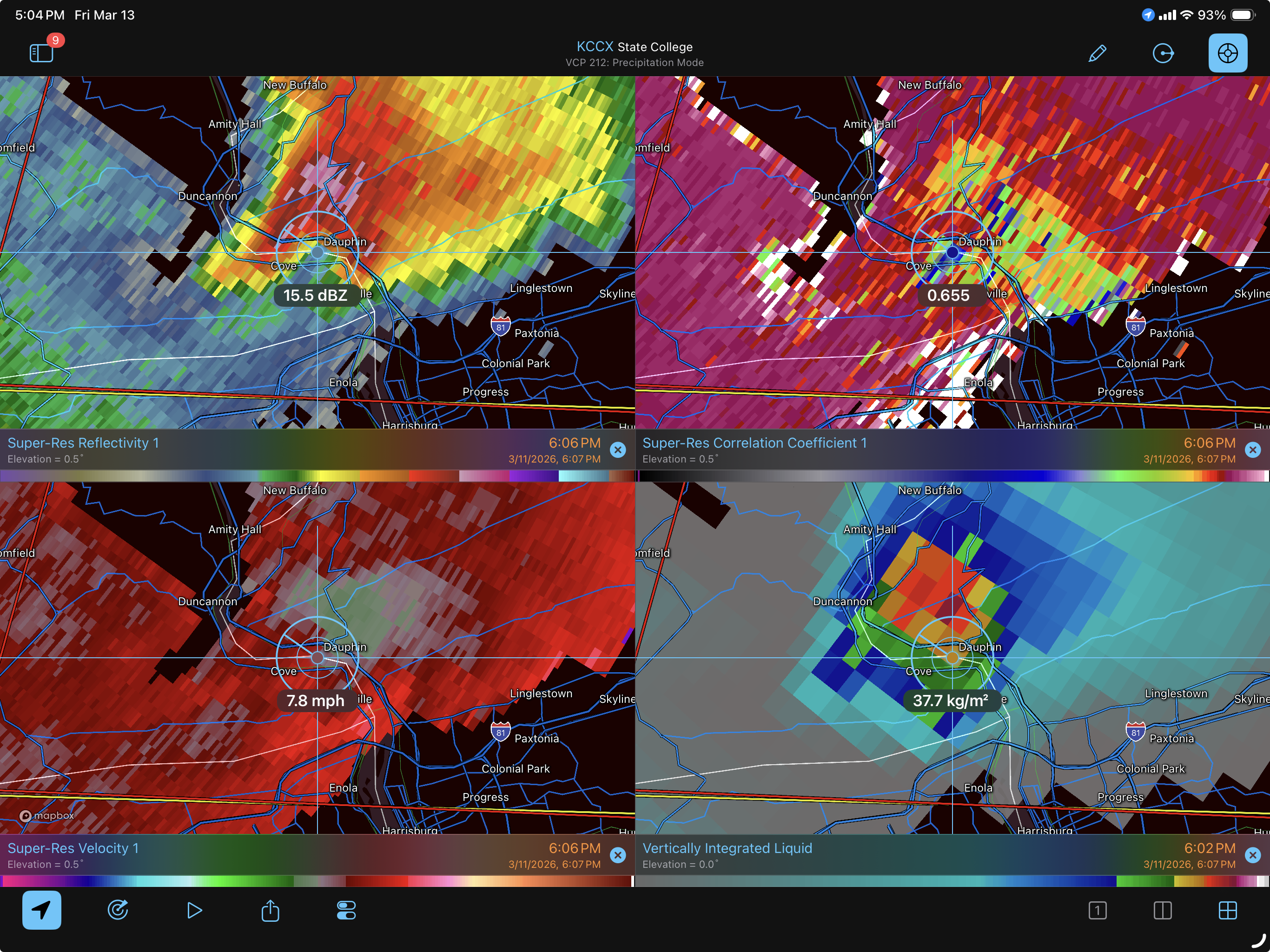
When I ponied up and upgraded my RadarScope to the Pro subscription this winter I forgot one of the features was archived radar data. So this is a really good example to try it out and review something. Basically, I’m not doubting the chances that this storm might have spun something weak up somewhere along the way but I think this posted screengrab of the CC labeled as a debris ball to prove a tornado on the ground is a bit of a stretch. So here’s the 606pm image that was shared, crosshairs placed on the “debris ball” One thing about debris ball signatures is the area of low CC values are usually co-located to an area of high DBZ reflectivity values, which this CC signature is not. They’re also typically associated with established, strong tornadoes (>EF2), which I’m not really seeing the support for on velocity data, or obs/local storm reports. Even though this passed thru a relatively sparse area, it did still cross US 22/322 during this period. There weren’t very many reports on this storm at all looking over the LSR’s. This signature likely had more to do with the hail core that this cell did have with it, which will reduce the CC values and can also cause a corridor of reduced values in the downstream direction of the radar beam when there’s a pretty decent hail core.. which can be seen on the images.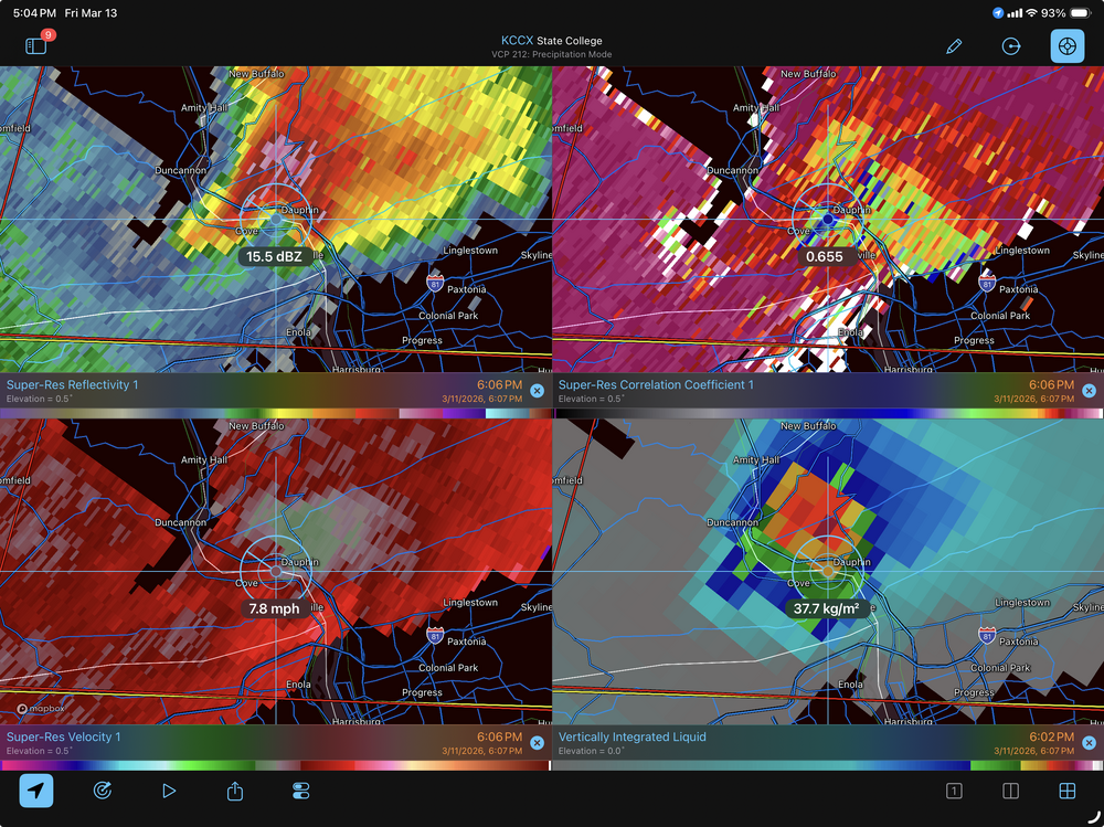
-
@CAPE @stormtrackerDFH 120 is being shipped out and hitting local shelves soon.
-
Central PA Spring 2026 Discussion/Obs Thread
Yardstickgozinya replied to Voyager's topic in Upstate New York/Pennsylvania
Quasi linear convective system with embedded rotations is the mode they keep throwing out although there is talks of more discrete development out ahead, even into Pennsylvania. I would indeed bet that some of those segments, and even the whole line could qualify ifor derecho status if the parameters should be realized. -
All the usual disclaimers for the NAM at range but what an impressive looking front.

-
I wish there were more MN posters. I can only post so much on the weekdays with job and parenting duties. NAM has me nervous but I’m chalking it up to NAM doing NAM things. 8-24” is a comfortable range at this juncture.
-
Was outside in a wide open field helping a student setup her research project... felt like I was back in North Dakota today! Fun times!