All Activity
- Past hour
-
That's a nasty line heading northwest through Frederick county.
-
Falling apart on us. Frederick getting the food for the fifth time today though!
-
Basically a July temperature forecast here. Can’t even muster up any precipitation, drought starting earlier this year.
-
From droughts to flash flooding! Crazy
-
still drier W of BWI than Carrie Nation's home town
-
The Richmond anti rain force field is now the Central MD force field. How is this happening with 80+% humidity?
-
Heavy rain again...
-
not bad in Worcester Heavy Rain Fog 48°F 9°C Humidity 100% Wind Speed E 7 mph Barometer 30.28 in (1025.8 mb) Dewpoint 48°F (9°C) Visibility 0.25 mi Wind Chill 45°F (7°C) Last update 5 May 7:54 pm EDT
-
close to a inch here today
-
Been sipping on a dfh 120 for the last 45 minutes waiting on the rain. Gonna have to move on to #2 soon because the rain is taking forever to advance north in AA county.
-
Was an amazing day out. Got up to 69 at the house. Rest of the week should be beautiful too - in the 60s and 70s
-
Yeah finally a nice hit by some good rains and some rolling thunder too! Much needed for my parched garden
-
A paltry .22” here today.
-
Damn I’m 2.5” today 3.8” since Friday night
-
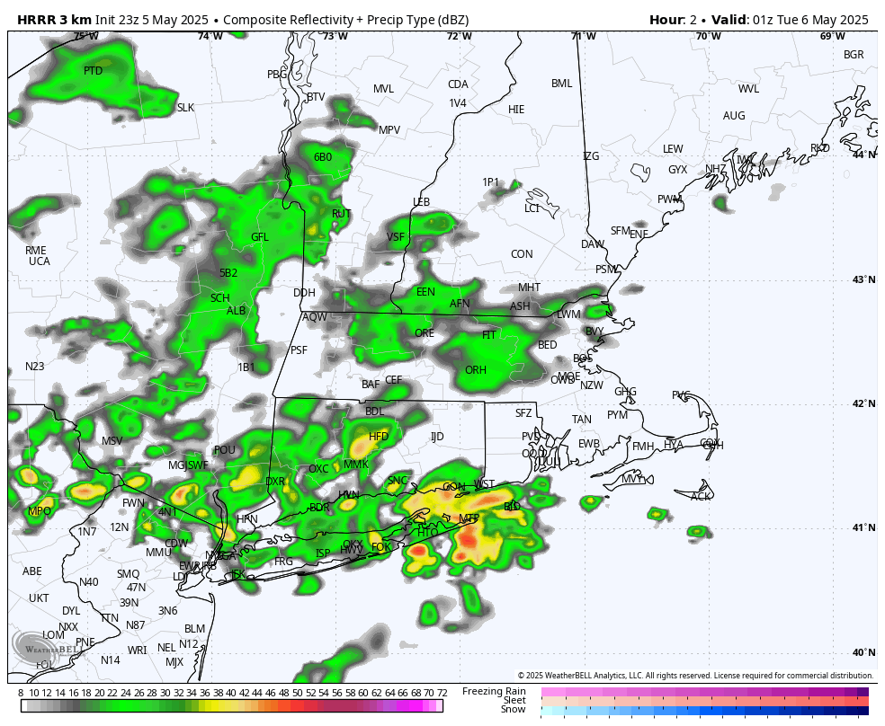
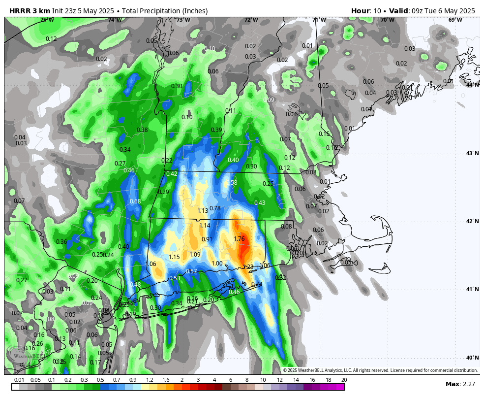
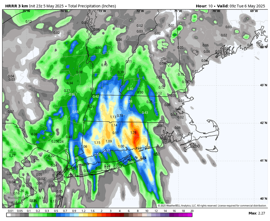
Agreed. We'll see. The latest HRRR had this radar for 8pm, which doesn't look too far off. Not sure what to make of it, ha. I don't see on the radar the localized 1-1.5"+ amounts... need more convection that's not there. But then drops this by 5am.

-
Give me as much juice as possible. Today has been kind of a “bust” imby. Typical. That said, I’m still at 1.23” since Friday. Some PWS in SE CT over 2” today.
-
Additional rain is likely tomorrow and Wednesday. It now appears that the dry respite will be brief. Another storm could affect the region Friday into Saturday before a cooler drier air mass arrives. The ENSO Region 1+2 anomaly was +0.1°C and the Region 3.4 anomaly was -0.1°C for the week centered around April 30. For the past six weeks, the ENSO Region 1+2 anomaly has averaged +0.68°C and the ENSO Region 3.4 anomaly has averaged -0.05°C. Neutral ENSO conditions will likely continue through at least early summer. Early indications are that summer 2025 will be warmer than normal in the New York City and Philadelphia areas. The potential exists for a much warmer than normal summer (more than 1° above normal). The SOI was +1.47 today. The preliminary Arctic Oscillation (AO) was +0.778 today.
-
That derailed quickly.
-
Radar looks totally unimpressive for tonight at least early. Maybe tomorrow.
-
My mistake he said 3 to 4
-
The Yankees are playing in this weather lol.
-
Brunswick had a rainy afternoon. Short term we are saturated. Much needed dousing of over 3 inches in the last 72 hours and more incoming before it is over. Been a long time coming....
-
The comparison to the great K-T event is what would finally fix our climate change and human overpopulation problem, both in one shot.
-
I think he was a bit higher… I had the 2-3 for DIT over the whole period (2” or more).
-
Somewhere in SE CT should be pretty wet. GON with like 1.5” since midnight? I will say I expected some heavier rain rates in the higher DBZ cores. But no one is doing like the 1/2 - 1” in an hour type stuff.