All Activity
- Past hour
-
Haven't had a day with 1"+ since early December; first year to get past June without at least one. Since the light showers on 9/7, not a drop.
-
Going to mow the lawn possibly for the last time this weekend, Only been mowed twice in the last 6 weeks, Chance of a frost this weekend would be the icing on the cake to end the grow season officially.
-
I'm aware of that but .. I don't believe they have that right. The ENSO and the La Nina apparent fingerprint is coincidental in that sense - not being forced by the ENSO state/thermal distribution as it terminates into the westerlies. It just so happens to be that in the absence of either, there is a feeble ONI that encourages upwelling over the eastern Pac but it doesn't really reflect a La Nina. Makes it exceedingly difficult to parse the two apart, sure.. because the expanding HC and the break down of that device/organized circulation machinery, lends to a residual SS stressing that orients E --> W In other words, the correlation is too linear.
-

2025 Atlantic Hurricane Season
NorthHillsWx replied to BarryStantonGBP's topic in Tropical Headquarters
If the follow up wave does not develop, there are some mild concerns down the road it might ride the low level flow further west and develop closer to home. Some ensemble support for development in SW Atlantic from the lemon highlighted by NHC. With everything else pretty dead, at least something to watch -
lol...this POS storm pretty much sums up the whole season.
-
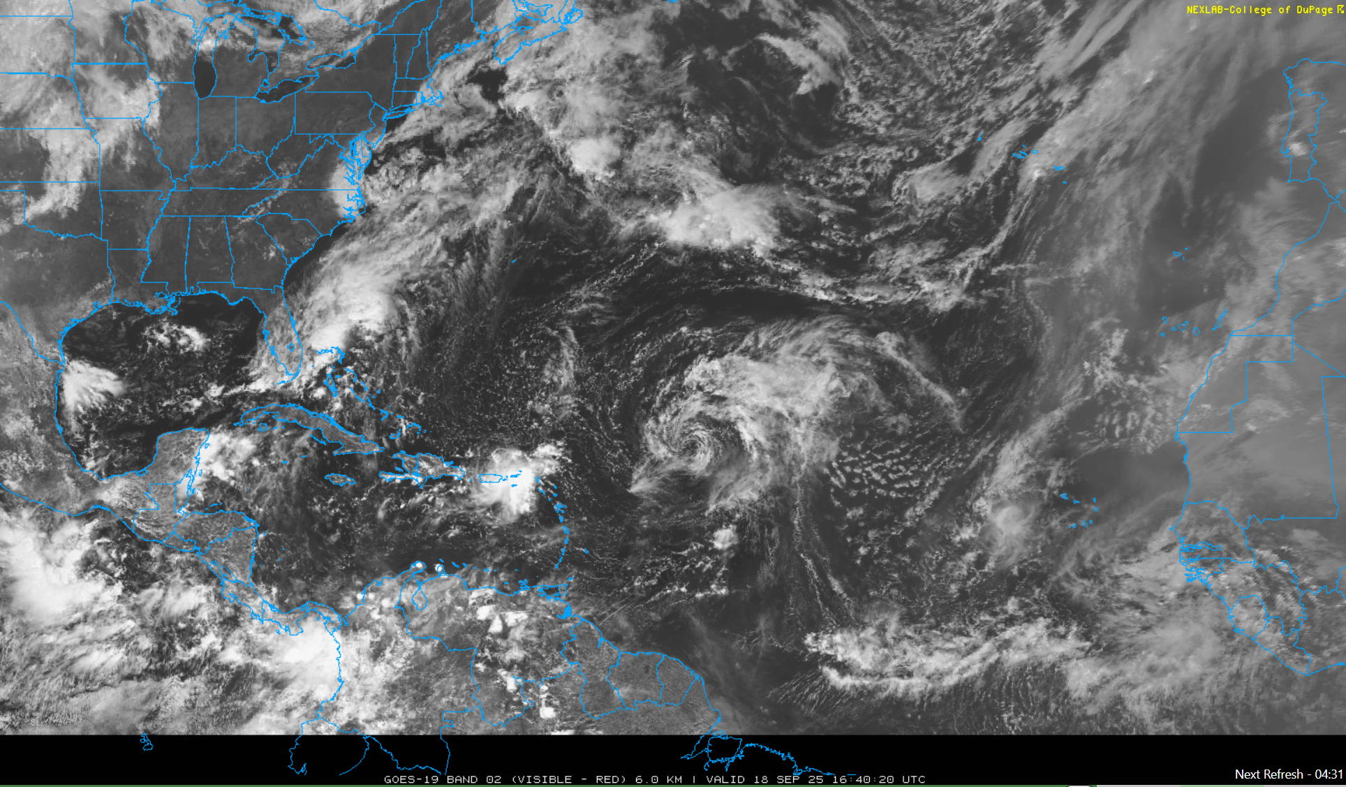
IMO, they named this storm before it met tropical cyclone criteria, namely it didn’t have a closed circulation. It has certainly acquired that now, but with 0 convection, this should be a depression at best. I will go on a limb and say, there is NO way this is producing TS force winds right now
-
reminds me of briefly living in san diego. Was great wx most of the time, but missed the four seasons. Left and came back after 1yr.
-
Fwiw - That's houses and the rebuilt elementary and middle school (Crenshaw) in Crystal Beach after Ike. All of that construction had nothing to do with Harvey and was done due to Ike.
- Today
-
Can't think of a more boring stretch in my life
-
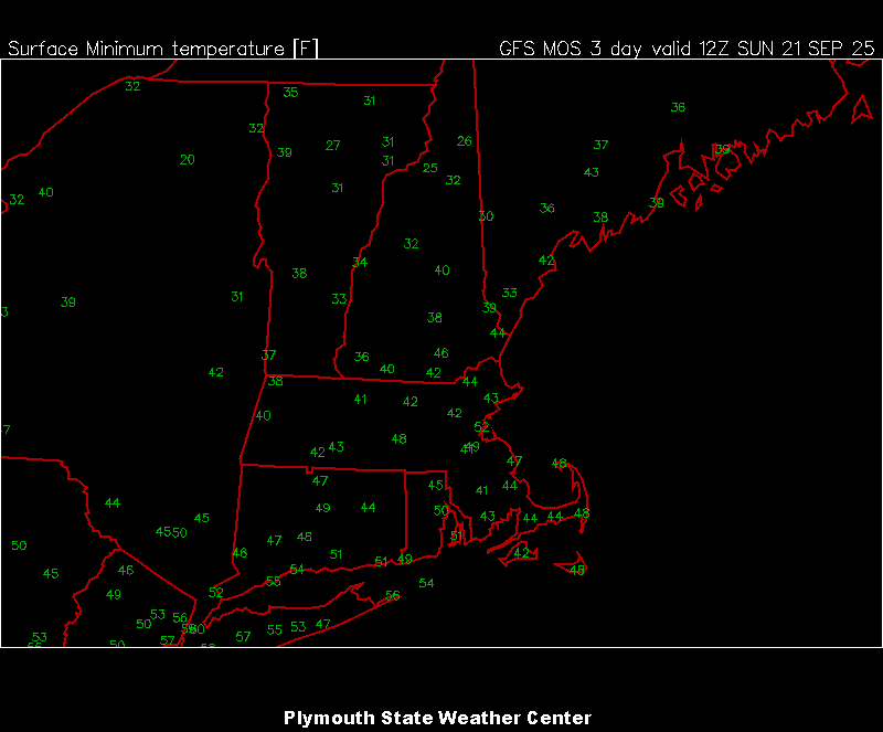
12z mex mins for Sun AM
-
I think these warm blobs are nothing more than a result of the pattern and not an influencer of the pattern. I think it could help feedback but no way can it overpower other influencing factors IMO.
-

September 2025 OBS-Discussion centered NYC subforum
SACRUS replied to wdrag's topic in New York City Metro
78 / 63 sunny and warming. Low - mid 80s Thu / Fri ahead of the front. Cooler but another dry weekend. Warmer overall Mon - beyond. Next threat of rain comes 25 - 27, otherwise dry. -
Maybe the happy middle is naming non tropical storms and use a naming convention that is different than what is used for tropical storms. This would raise public awareness to a certain degree. Off the top of my head, maybe use the NATO Phonetic alphabet for non tropical storms. https://en.wikipedia.org/wiki/NATO_phonetic_alphabet
-
The Pacific is showing some large scale cooling in recent days, have to see if that is just the beginning of something or a blip in the road.
-
Thanks for sharing. I can attest to how this approach does mitigate flood damage to homes. My home on St. George Island is on 12' pilings. I had two feet of water under my home from Helene last year. It was not from storm surge but from excessive rainfall that had nowhere to go because the water table was full. That article is misleading in that it does not mention the 15' requirement. The article mentions a 2' requirement if building on a 100 or 500 year flood plain but that may be not be enough based on what Harvey did.
-
Finally getting some clearing here. Local observations put the event just under 2" for us. Seemed like a lot more than that.
-
If this dry pattern continues into October and it looks like it will, my fear is that this drought has a chance of becoming worse than last fall….that dry pattern didn’t start until after mid-August, this one started at the tail end of July
-

September 2025 OBS-Discussion centered NYC subforum
uofmiami replied to wdrag's topic in New York City Metro
Understood, totally agree. -
Wife and I were joking that our dog got a new house on our land way before us lol. So why not... auto water and maybe a pinball machine and mini fridge.
-

September 2025 OBS-Discussion centered NYC subforum
donsutherland1 replied to wdrag's topic in New York City Metro
I meant for this to be in the banter thread, but the point is that one has to use established definitions consistently for clear communication. Otherwise, confusion can erode preparedness and public safety. -

September 2025 OBS-Discussion centered NYC subforum
anthonymm replied to wdrag's topic in New York City Metro
Yeah we're easily in the lowest multiyear snow drought. The scary thing is I think the pattern is set. NYC will likely have a mean around 15" for good now. -
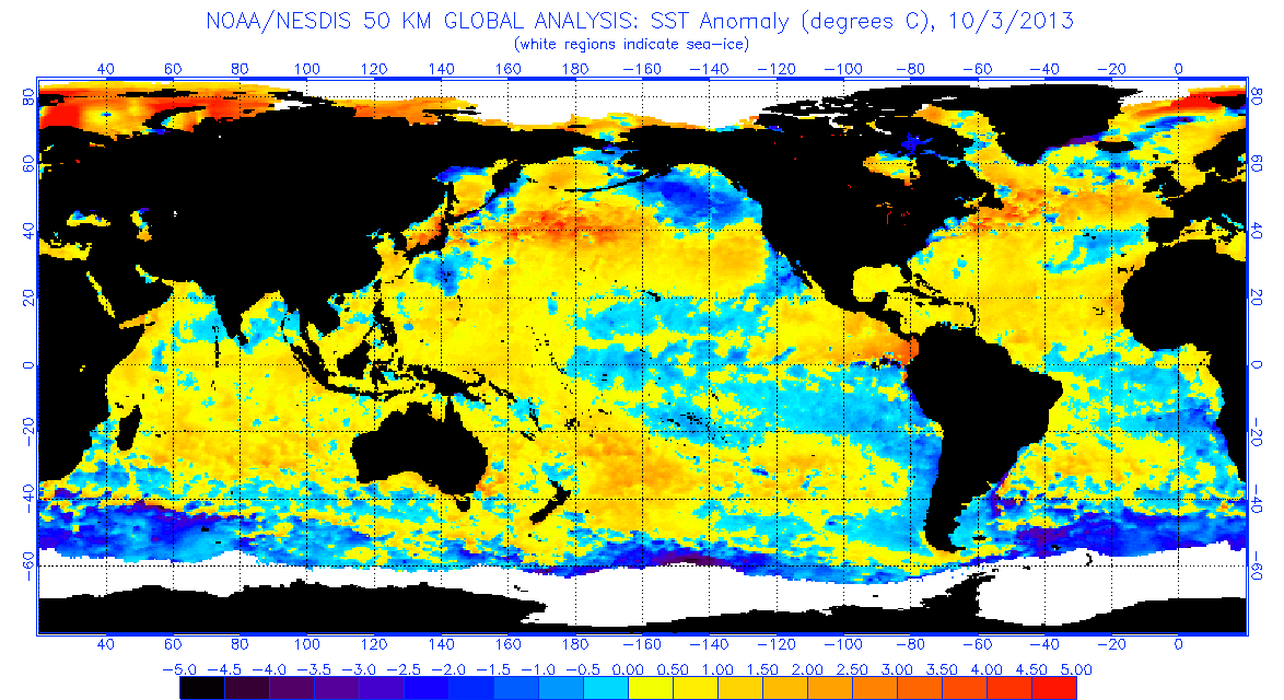
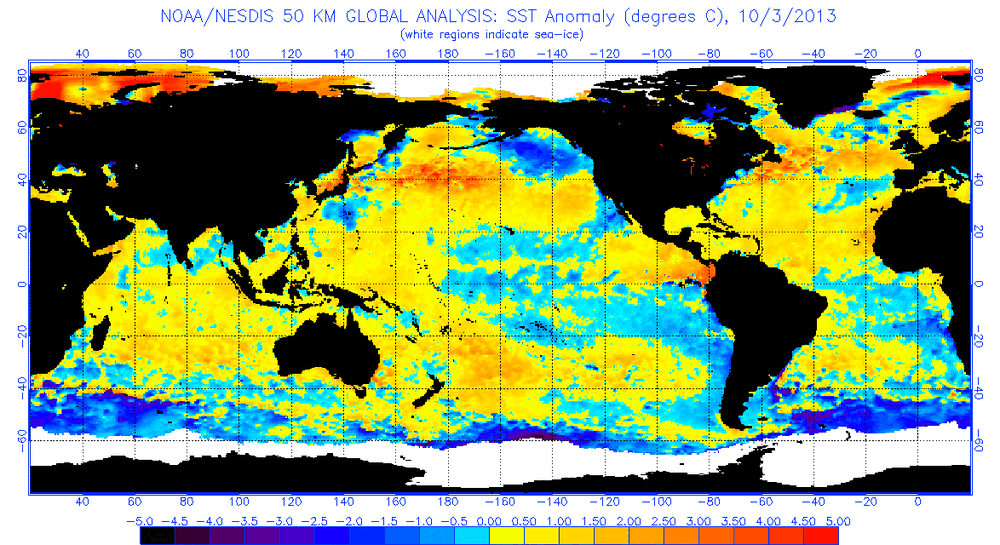
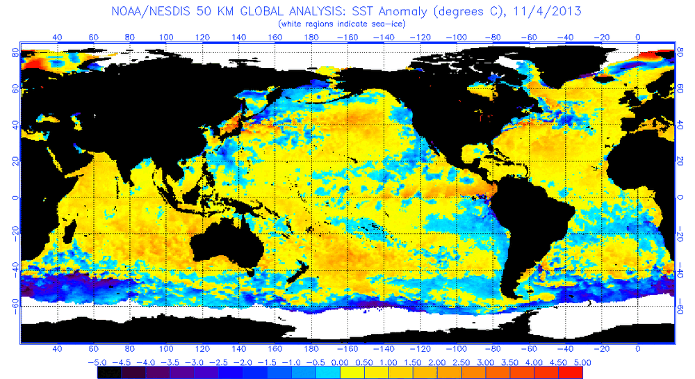
We kicked around the chicken/egg debate quite a bit that year. Looking back at historical data it looks (to me) that the initial warm pool was the direct result of a persistent anomalous pattern causing the PDO to spike and then some sort of feedback. SSTA plots through the fall of 2013 don't look like a harbinger to me. The NE pac was loaded with BN temps in early October but then flipped over the next month into Nov. But the PDO was spiking during that time which makes sense. Persistent troughing near Japan would naturally have a downstream ridge. Then in Dec the -epo kinda shoved the warm pool further east into the GOA region. When I look at this stuff from a 10k' view, the +PDO was the catalyst for the SSTA configuration leading to the "warm blob". The blob got bullied and enhanced by a anomalous -epo pattern that kept reloading. We've discussed this before but worthing pointing out again.... the NE pac has a cold current and is never "warm". So 5 degrees above normal is still pretty cool. Hard to say how much influence that area of the Pacific can have on the upper levels of the atmosphere. Imho, the upper levels drive the bus and not the other way around in this specific region. But having the type of ssta configuration we has in 2013-14 was most definitely an important clue or guage of what was going on in the atmosphere. If this winter isn't going to be a dud, the crazy -PDO has to implode at some point leading into met winter. You've pointed this out already but if the PDO is roasting when we're eating turkey and watching NFL games... I won't be very optimistic
-
September 2025 OBS-Discussion centered NYC subforum
uofmiami replied to wdrag's topic in New York City Metro
Well compared to naked swirl aka Gabrielle, maybe he has a point, haha I don't get how Gabrielle exists at the moment. -
Yeah the winter pattern is set. The warm blob's gonna go away, the western pac will boil. We'll get a horrible zonal pac jet that floods the east with warm mild air, and the rockies and west will get freezing cold and snowstorms every day. 22-23 / 23-24 repeat, but possibly worse.
-

September 2025 OBS-Discussion centered NYC subforum
STORMANLI replied to wdrag's topic in New York City Metro
Well said. Cold-core low. That alone should dispel any argument.