All Activity
- Past hour
-
The seabreeze usually can make its way onto the barrier islands early from my experience, then we see how fast it can get inland. If there’s a strong WNW flow it might have trouble getting beyond the Southern State at least before it gets to upper 90s/100, and compressional heating might make it worse and the hot spot area wide. Central Queens/Nassau might make a run at 102/103 if we have the crawling seabreeze running into the strong WNW wind. But stronger seabreeze, no seabreeze are wild cards.
-
Just past 10:42pm. The sun has gotten as far north from the equator as it will ever be this year over the western Pacific Ocean! @CAPE Your worry about your lawn being incinerated will soon be on borrowed time as the solar noon sun angle eventually lowers behind your trees. Hot summer weather lovers rejoice for your time of celebration has come! Cold weather lovers you all rejoice as well for the days will get shorter with the sun angle lowering from here on out until the winter solstice, ensuring that the heat and humid will also eventually abate.
-
Lake Clark, Lake Aldred, and especially Conawingo reservoir all can experience three even four foot white caps every few years if the winds blow up the river correctly. We had a few guys get swamped and overturned in a tortament on Lake Aldred in 2011 from a pop up storm, one was in a 24 foot sea ark. I also saw a group almost get blown over Holtwood dam during a storm before the flashboards were put up because there outbord was way underpowerd for the Pontoon, and they didn't know to put down their bimini in wind. The river can change quick and take life in a heartbeat along with the people that have to attempt the rescue. The Sus is a heartless killer.
-
One of my favorite things in life. That particular south Florida smell, the heat. Something unmistakable at FLL.
-
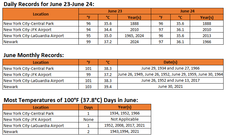
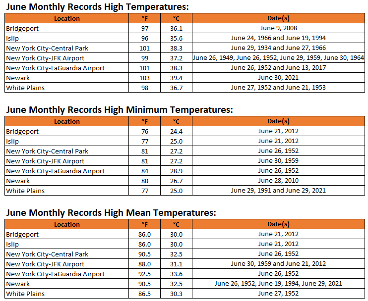
Expanded lists of June record high maximum, minimum, and mean temperatures for the New York City area are below:
-
 benife joined the community
 -
Hrrr trying to ruin Sunday heat with debris clouds
-
I'm seeing mid 80s right along the coastline.
-

2025 Short Range Severe Weather Discussion
MidwestChaser replied to Chicago Storm's topic in Lakes/Ohio Valley
Big tornado in North Dakota right now: -
While New York City waits for the onset of potentially extreme heat, New York City tied the June monthly record for smallest daily temperature range on June 9. The temperature range was just 2° (high: 64°; low: 62°). That tied the June record that was set on June 8, 1869 and tied on June 11, 1910, June 8, 1916, June 20, 1958, and June 17, 1978. June 17, 1978 also had an identical 64°-62° daily range.
-

2025-2026 ENSO
40/70 Benchmark replied to 40/70 Benchmark's topic in Weather Forecasting and Discussion
https://easternmassweather.blogspot.com/2025/06/strong-consensus-for-marginal-la-nina.html -
https://easternmassweather.blogspot.com/2025/06/strong-consensus-for-marginal-la-nina.html
-
Monday/Wednesday softball games gonna be goood
- Today
-
Beautiful day. 84, Sun, and pool. Trenton is usually hot, so it being 1 degree warmer than nyc, who cares? Plenty of stations all around today were 82.
-
Dew points have been steadily rising all day. We are now up to 73. Tropical out there.
-
Thunderstorms fell apart by the time they hit my area. Only got .10" from them. Big news was the much cooler weather and lower dew points. High was 87 with dew points in the low 70's much of the day. Nice breeze all day long. Not looking forward to next week.
-
tbh I am really sensitive to any stinging/blood-sucking insects, and the usual allergies. epipen. Carhartt/Hoodie until it's like 95/75 or unbearable
-
80% of us basically have natural immunity. https://www.rockefeller.edu/news/34384-an-immune-flaw-may-cause-west-nile-viruss-deadliest-symptoms/
-
It’s been awhile for a super long track derecho. See how it plays out.
-
Some people not really expecting severe weather could get quite a surprise if the Derecho keeps up steam
-
I was just reading into some of the old analogs. That’s a good one
-
01z outlook is a perfect match to the track of the 1995 right turn Derecho
-
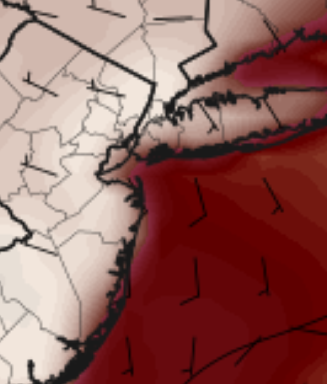
That's one of the hottest parts of the NJ coast on the 18z NAM at 5PM Monday. This is fickle though so I'm sure it will change:

-
How much of a sea breeze will there be in places like Long Branch NJ on Monday?
-
105 mph is wild. URGENT - IMMEDIATE BROADCAST REQUESTED Tornado Watch Number 448 NWS Storm Prediction Center Norman OK 750 PM CDT Fri Jun 20 2025 The NWS Storm Prediction Center has issued a * Tornado Watch for portions of Northwest into West-Central Minnesota Central and Eastern North Dakota Northern South Dakota * Effective this Friday night and Saturday morning from 750 PM until 300 AM CDT. * Primary threats include... A couple tornadoes possible Widespread damaging winds expected with isolated significant gusts to 105 mph likely Scattered large hail and isolated very large hail events to 2 inches in diameter possible SUMMARY...An intense squall line is forecast to rapidly move east across the Watch area this evening into the overnight period. A potential supercell tornado risk may develop with any storms that develop ahead of the squall line. A tornado risk may accompany the stronger and more persistent embedded circulations within the line. Widespread severe gusts (60-80 mph) are expected. Swaths of 80-105 mph gusts are possible with the more intense portions of the convective line.
-
I mowed today too, so there you go lock it up


.thumb.jpg.6a4895b2a43f87359e4e7d04a6fa0d14.jpg)