All Activity
- Past hour
-

January 2026 regional war/obs/disco thread
moneypitmike replied to Baroclinic Zone's topic in New England
Great news. Wake me if they start showing Maine. -
You have the qpf map?
-

January 25/26 Jimbo Back Surgery Storm
NorthHillsWx replied to Jimbo!'s topic in Southeastern States
I was there. I lived in Alexandria at the time. There were 4’ “drifts” by sloped roofs where it had bounced off and accumulated below. That was a glacier until March. Also- that storm was progged to be ZR and it ended up 99% sleet. Very very fond memories of that event up there, gave me a deep appreciation for a heavy sleet storm -
2025-2026 Fall/Winter Mountain Thread
CheoahBald1 replied to Buckethead's topic in Southeastern States
You might wanna show us the 6z gefs and 6z NBM . -
If we totally decoupled, it would have been colder but winds stayed ~3-7 mph most of the night. Low was 0.7. Almost made it below zero for the first time this season.
-
I would assume so.
-
I don’t believe the NBM has a Kuchie.
-
Good thing about the 6Z GFS coming into line is that this lessens the risk from the southern stream/cutoff. It was consistently the slowest and most guidance has trended slower and stronger with it over time. Gives some confidence in it not getting stuck or coming out too piecemeal. We have other potential issues, like interaction with the trailing NS wave, but the big failure modes are getting crossed off first.
-
Assume that’s 10:1 too?
-

January 2026 regional war/obs/disco thread
jbenedet replied to Baroclinic Zone's topic in New England
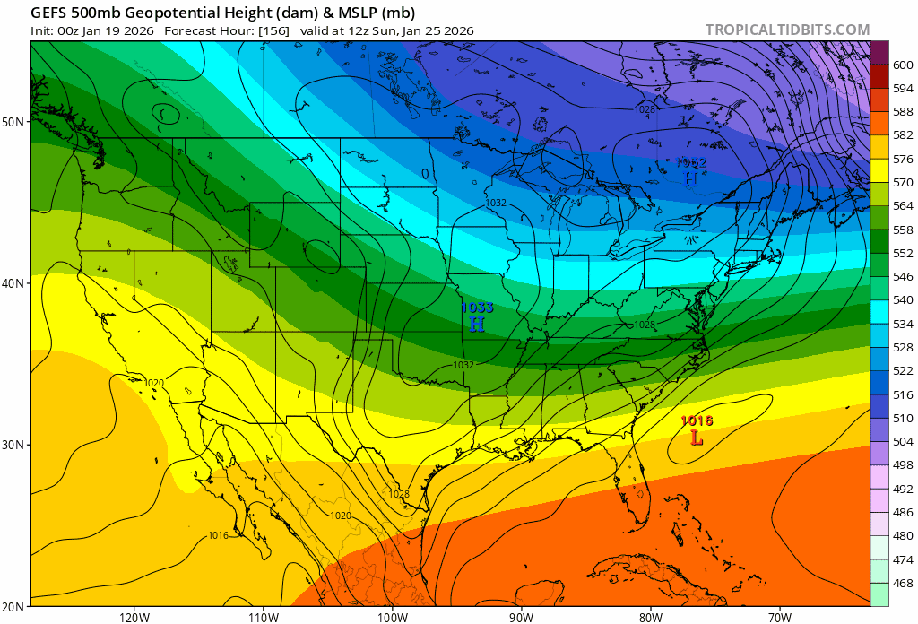
More ridging but stronger surface high and positive tilt. I think the trend on overnight guidance was to load up this already-explosive setup by tightening the delta between the arctic and the tropics. -

January 2026 regional war/obs/disco thread
40/70 Benchmark replied to Baroclinic Zone's topic in New England
Jesus, I have never seen DT so amped up...telling people prepare to have the kids out of school all week...looking at snow maps and saying "OMG, I hope that doesn't verify"....I'm thinking "you're so full of shit" -

Texas 2026 Discussion/Observations
DFWWeather replied to Stx_Thunder's topic in Central/Western States
Here was my post from the other thread. For DFW, we are looking at a major winter storm this weekend with all models and their ensemble suites predicting a mind blowing 2 plus inches of QPF in solidly subfreezing air. If this verifies anywhere remotely close to that, the Metroplex will be totally shut down. In addition, the threat for severe cold (10 or lower at DFW) has increased significantly with most models and their ensembles clustering around 10 to 15F on average. There is a ~1050 to 1055mb Arctic high parked in the Dakotas bleeding cold air into the northern half of the state. -

January 2026 regional war/obs/disco thread
SouthCoastMA replied to Baroclinic Zone's topic in New England
Might be some ocean effect along EMA with that look -
DC area had about that much in the 06-07ish timeframe. Was like walking through beach sand. Very little stuck to the trees which made the scene look odd.
-
Lol i just checked the Philly sub they're both already on it
-
Fell asleep again.... mid late morning Sunday.
-
Wow, about as good of a blend we can get
-
Can someone post the 0z eps? I didn’t see it in the thread. With comparison to 12z would be appreciated. Thanks! .
-
A nice chilly 12.0/-0.7 with clear skies at 7 am here. Wind W at 7 gusting to 13 mph making WC 1 to -3. Low was 11.9 degrees at 6:25 am. I see Canaan NWR is a crisp -1 this morning.
-
January 25/26 Jimbo Back Surgery Storm
NorthHillsWx replied to Jimbo!'s topic in Southeastern States
Agreed. This is the rare event where, with 2+” of QPF possible some areas could mix for over half the storm and still end up with a foot of frozen. This isn’t wasting half our 0.30” in mix like we’ve become accustomed to… -
January 2026 regional war/obs/disco thread
jbenedet replied to Baroclinic Zone's topic in New England
The surface high is intensifying over our heads on guidance. I’d call it Canadian but it’s over our head throughout. Filling in for Quebec.. Great news for our southern neighbors who love snow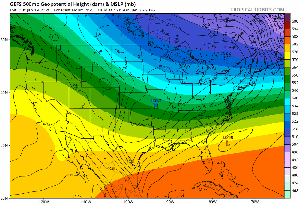
-
Already working on it
-
 I think the mesos will continue to be useful for some time.
 -

Possible Record Breaking Cold + Snow 1/25 - 1/26
psv88 replied to TriPol's topic in New York City Metro
18”, Southern side of Commack NY -

Possible Record Breaking Cold + Snow 1/25 - 1/26
sussexcountyobs replied to TriPol's topic in New York City Metro
27.5" thus far in Vernon Twsp. @ Canistear Reservoir

.thumb.JPG.418e8a9a2902ae687ec35ff4bc0e038e.JPG)