All Activity
- Past hour
-
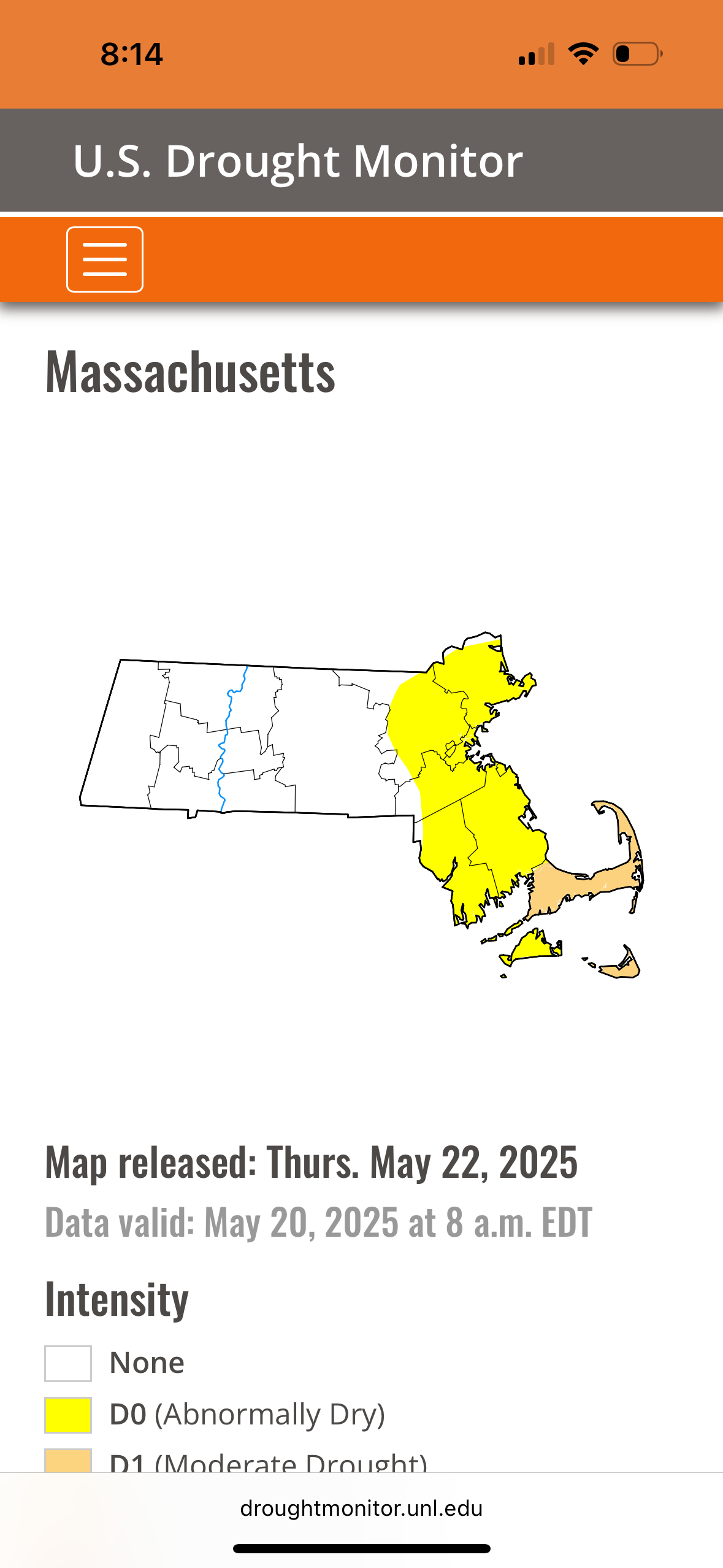
As of the latest update(yesterday) a small area in north central MD- much of Baltimore county and parts of Carroll and Harford- are still in a severe drought. Areas surrounding that are Moderate. Better further east- my yard is on the edge of abnormally dry, and nothing points S and E from there. But yeah there has been marked improvement in the past couple weeks. Not sure why he wouldn't be discussing that rather than being a hypester.
-
1.12” for the week, and looking forward to a perfect weather weekend.
-
Breaking 100+ year old cold records, I thought it was impossible. Shocked there were no posts about it from all the stat geeks here (not really). Almost the same here, 1.56"
-
Minneapolis v Paducah May average temperature update. MSP: 60.5 PAH: 66.4 Yesterday was our first high above 60 since the 16th. Temperatures look to stay average/slightly below average through the next week.
-
I’m going to need spf 500 on monday
-

E PA/NJ/DE Spring 2025 Obs/Discussion
JTA66 replied to PhiEaglesfan712's topic in Philadelphia Region
1.70" A little more than 9" for the month 52F -
Coastal pulling away and lingering rain into NY
-
Euro still not updating there but it is more similar to the GFS with trough still clinging to the northeast (ish) 5/30 - 6/1). Heights poised to rise in the 6/5 - beyond.
-
He couldn't say, but If I had to hazard a guess I'd think there would be some flakes flying there too.
-
Coastal low slowly pulling away in the northeast and pronounces breaks and clearing into PA. Perhaps by noon we can get into breaks of sun or better - heres hoping
-
Records: Highs: EWR: 96 (1964) NYC: 94 (1964) LGA: 94 (1964) JFK: 92 (2021) Lows: EWR: 43 (1931) NYC: 43 (1963) LGA: 45 (1963) JFK: 33 (2022) Historical: 1882 - An unusual late season snow blanketed eastern Iowa, with four to six inches reported around Washington. (David Ludlum) (The Weather Channel) 1953 - The temperature at Hollis OK soared from a morning low of 70 degrees to an afternoon high of 110 degrees to establish a state record for the month of May. (The Weather Channel) 1987 - It was a busy day for thunderstorms in the central U.S. Thunderstorms produced wind gusts to 65 mph at Shreveport LA and golf ball size hail at Marfa, TX. Hobart, OK, received 3.55 inches of rain in the morning, and another 4.03 inches of rain that evening. Thunderstorms in Nebraska produced 8.5 inches of rain in two hours north of Potter, and 7.5 inches of rain in ninety minutes north of Minatare. Thunderstorms in Colorado produced five inches of hail at Greeley. (The National Weather Summary) (Storm Data) 1988 - Thunderstorms produced severe weather across much of the eastern U.S. Golf ball size hail was reported in Georgia, Maryland, North Carolina, South Carolina and Ohio. (Storm Data) (The National Weather Summary) 1989 - Severe thunderstorms developing along a cold front resulted in 98 reports of large hail and damaging winds in the Northern Plains and Upper Mississippi Valley. Golf ball size hail caused a million dollars damage around Buffalo City, WI, baseball size hail was reported at Northfield and Randolph, MN, and thunderstorm winds gusted to 95 mph at Dunkerton, IA. (The National Weather Summary) (Storm Data) 1989 - Unseasonably hot weather continued in the south central U.S. Pueblo, CO, equalled their May record with a high of 98 degrees, and the high of 106 degrees at Midland, TX, marked a record six straight days of 100 degree heat. (The National Weather Summary) 1990 - A cold front crossing the western U.S. produced snow over parts of Oregon, California, Nevada, Idaho and Utah, with five inches reported at Austin NV, and four inches at Crater Lake National Park in Oregon. Strong winds behind the cold front sharply reduced visibilities in blowing dust over central California, and two multi-vehicle accidents resulted in one death and eighteen injuries. In northern Idaho, a cloud-burst washed tons of topsoil, and rocks as large as footballs, into the valley town of Culdesac. (The National Weather Summary) (Storm Data) 2002: A Pacific storm system brought some much needed snow to the Colorado Mountains and foothills with a mix of rain on the Plains. Snowfall totals included: 13 inches at Coal Creek Canyon, 11 inches near Evergreen, CO. The former Stapleton International Airport at Denver reported less than an inch. Three temperature records were set. The morning low temperature of 31° was a record low; as was the morning low of 32° the following morning. The high temperature of only 48° equaled the record low maximum.
-

2025-2026 ENSO
40/70 Benchmark replied to 40/70 Benchmark's topic in Weather Forecasting and Discussion
I really don't understand how waiting for more data and a larger sample can be wrong.... I don't disagree regarding what has been happening, but I think any implications concerning the future, aside from general warming, needs to be tempered for now. -
2025-2026 ENSO
40/70 Benchmark replied to 40/70 Benchmark's topic in Weather Forecasting and Discussion
Yes, this also plays into the pattern, which has sucked for the past 8 years or so. I understand that although you won't admit it, you strongly hedge towards this being permanent. I am not there yet. We will find out in a few years. -
sun broke out. https://www.star.nesdis.noaa.gov/GOES/sector_band.php?sat=G19§or=ne&band=GEOCOLOR&length=24
-
My point is that any winter month when some portion the coldest departures in the Northern Hemisphere are found in the CONUS is becoming less frequent. Plus when you add a less intense cold pool like last January centering in the U.S. the results aren’t as extensive or intense as past instances. The cold pool departures last January were much less impressive than the last time the coldest departures were in the CONUS like February 2021 and February 2015. Getting a replica of 2015 has several challenges that I can see. First, the planet has had two tremendous baseline jumps in background temperature during 2015 into 2016 and an even greater jump the last 2-3 years. So this naturally weakens the cold pool. Second, the more extensive warming of the WPAC has been associated with a faster Northern Stream of the Pacific Jet. The faster jet keeps sending pieces of energy into the NEPAC blocking causing it to weaken. So we haven’t able to reach the blocking levels there we saw in 2013-2014 and 2014-2015. This was the case over the recent 2024-2025 winter. Third, getting a weak Modoki El Niño like February 2015 has been a challenge with the WPAC warm pool expansion. So the attempts in 2018-2019 and 2019-2020 didn’t work out.
-
-
1.23" for the event. My garden is swamped but doing fine. Justin Berk is still hyping the drought on Facebook. The comments were funny. I think we're safe from running out of water. Edit: I see blue sky to the west!
-
Millersville high yesterday was 56 breaking the low max temperature record by 4 degrees.
-

Central PA Spring 2025
Mount Joy Snowman replied to canderson's topic in Upstate New York/Pennsylvania
Another low of 49 and .52” of glorious soaking all-day rainfall, for an event total of 1.09”. -
50 / 48 misty / light rain and drizzle. Hour 60 of what should be 96 hours of clouds / mostly cloudy conditions, but this could extend into Sunday approaching 100 hours. Light showers rain becoming isolated mostly cloudy although there could be some breaks in the clouds stuck near 60. Tomorrow the ULL is over the the northeast and clouds lingering - a bit warmer / drier low - mid 60s. Sunday piece of energy over the GL dives south and could trigger some scattered showers and additional cloud cover - mainly dry / warmer near 70. Monday looks to break the streak fully with partly cloudy skies and temps neareer to normal low - mid 70s. Beyond there the trough remains into the Northeast with the month closing out near normal / perhaps a warm day or day / half 29-30 or 30-31. Still lingering trough and tendency for low cutting off from the trough before the warmth in heat goes north and east by the end of the first week of next month in the way beyond: 5/21 - 5/25 : Much cooler - cloudy wet 5/26 - Memorial day slavaged 70s and dry - partly - sunny 5/27 - 5/29 : Near normal - southern system may bring light rain 5/30 - 5/31: could end with a brief warmup Way beyond : warmer into the the 6/5 - beyond period (perhaps much warmer and hotter)
-
4.16
-
2025-2026 ENSO
40/70 Benchmark replied to 40/70 Benchmark's topic in Weather Forecasting and Discussion
I don't think anyone entirely understands the factors that determine how impressive the cold source becomes for a given season...while we can be sure that the trend is for it to become less impressive, its not a perfectly linear progression, so any given year moving forward may have a more impressive reservoir to tap.....though clearly the odds diminsh with time. -
Dreading putting the dock into the lake this weekend. Looking like upper 40's water temperature. Painful.
-

2025-2026 ENSO
PhiEaglesfan712 replied to 40/70 Benchmark's topic in Weather Forecasting and Discussion
What's impressive about the 2014 and 2015 cold outbreaks is that they didn't really get going until after the new year, and they went on for 2-3 months, not really letting up until the end of March. -
Kind of a fail for CNE, but temps always looked meh despite the weenie ptype maps.