All Activity
- Past hour
-
URGENT - WEATHER MESSAGE National Weather Service Baltimore MD/Washington DC 836 AM EDT Thu Jul 2 2026 DCZ001-MDZ004>006-008-011-013-014-016>018-503>508-VAZ037>040-050-051- 053>057-501-502-505-506-526-527-022100- /O.NEW.KLWX.XH.A.0002.260704T1400Z-260705T0000Z/ /O.CON.KLWX.XH.W.0002.260702T1400Z-260703T0000Z/ /O.CON.KLWX.XH.W.0003.260703T1400Z-260704T0000Z/ District of Columbia-Frederick-Carroll-Northern Baltimore-Cecil- Southern Baltimore-Prince Georges-Anne Arundel-Charles-St. Marys- Calvert-Northwest Montgomery-Central and Southeast Montgomery- Northwest Howard-Central and Southeast Howard-Northwest Harford- Southeast Harford-Albemarle-Greene-Madison-Rappahannock-Orange- Culpeper-Fairfax-Arlington/Falls Church/Alexandria-Stafford- Spotsylvania-King George-Northern Fauquier-Southern Fauquier- Western Loudoun-Eastern Loudoun-Northwest Prince William-Central and Southeast Prince William/Manassas/Manassas Park- 836 AM EDT Thu Jul 2 2026 ...EXTREME HEAT WARNING REMAINS IN EFFECT UNTIL 8 PM EDT THIS EVENING... ...EXTREME HEAT WARNING REMAINS IN EFFECT FROM 10 AM TO 8 PM EDT FRIDAY... ...EXTREME HEAT WATCH IN EFFECT FROM SATURDAY MORNING THROUGH SATURDAY EVENING... * WHAT...For the first Extreme Heat Warning, dangerously hot conditions with heat index values up to 111 expected. For the second Extreme Heat Warning, dangerously hot conditions with heat index values up to 112 expected. For the Extreme Heat Watch, dangerously hot conditions with heat index values up to 110 possible. * WHERE...Portions of DC, central, north central, northeast, northern, and southern Maryland, and central, northern, and northwest Virginia. * WHEN...For the first Extreme Heat Warning, until 8 PM EDT this evening. For the second Extreme Heat Warning, from 10 AM to 8 PM EDT Friday. For the Extreme Heat Watch, from Saturday morning through Saturday evening. * IMPACTS...Heat related illnesses increase significantly during extreme heat and high humidity events.
-

E PA/NJ/DE Summer 2026 Obs/Discussion
JTA66 replied to PhiEaglesfan712's topic in Philadelphia Region
85F/DP 76F as we approach 9am. -

Central PA Summer 2026 Discussion/Obs Thread
Mount Joy Snowman replied to Voyager's topic in Upstate New York/Pennsylvania
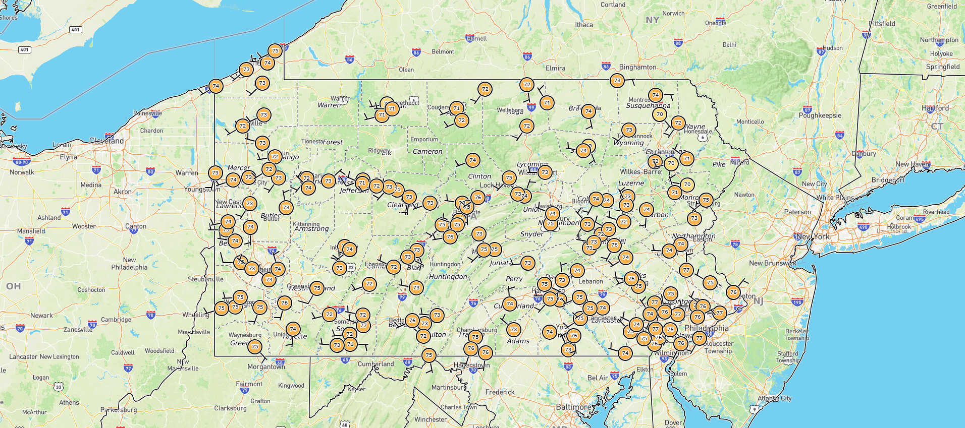
Low of 75. Let's see how high we can go. My forecast for tomorrow got knocked down a couple degrees to 101 but remains at 103 for today. White MDT fell a degree short of tying the record high for yesterday, it did set a new record max min of 77. We'll have to keep an eye on those max mins in the days ahead, although I think the upcoming days' records are more like 80. Don't get me started on home station dewpoints haha. Here is a map of current dews.....
-
Currently 87/75 at IAD 8:44am EDT.
-
 .17 last night with a few gusts and thunder. Seemed like we were about to get nailed but didn't amount to much.
 -
 Not rising as fast as one might expect for the advertisement - "90 by 9 am" is reasonable index finger method, and we're not going to make that. some 82's around but most sites are just 79 - with only 20 minutes of cooking time, it doesn't seem 90 as average site temperature by 9 am is very realistic. There is another adage that works statistically, though. "10 by 10" ... so we'll see where we are at that time. This could be a situation where that outflow stuff overnight swept through and processed out our launch pad - so we may just need the extra hour of process time to "catch up" to where we would have been if that did not take place. It's hard to run a historic high jump heat dunk day when the night before gets it's legs kicked out. It's going to be mid 90s/ 70billion one way or the other so it's really all just for show beyond that combination of hell, anyway. Hell, tomorrow could end up being the winner in this stretch - that is, if high heights actually do what they are physically supposed to do this time and that's not allow that kind of thing from timing that way.
 -
 84/79 already
 -
88/76 HI 99 at my station
-
Saturday afternoon with frontal sag ..
-
Currently 81/70 here in MB. But c'mon, man..."stifling?" You Alexandrians are beastly PROS at handling triple-digit heat in summer...
-

E PA/NJ/DE Summer 2026 Obs/Discussion
Lady Di replied to PhiEaglesfan712's topic in Philadelphia Region
08:30am 84F-79% humidity. DP 77. Yuck! Our low overnight temp is our seasonal high. How many days til Fall? -
 Beans and franks?
 -
86/76/96 where i am. I think a lot of us will be 90 by 10-1030.
-
Corona, Ozone Park, Brownsville, and Astoria already at 90°. https://nysmesonet.org/networks/nyc Corona Temp: 90°F 3h Precip: --
-
Thursday low imby/Columbia 79.9°
-
 Our home has trees 70-80 feet tall within 10 yards on 3 sides - 4th side same tree heights but 30 yards from the house. To make solar feasible we'd need to cut about a 3-year supply of firewood (5 cd/yr) and buy a new roof. No thanks. 2nd straight evening with all the action sliding to our south. Not even a flicker.
 -
My low was 65.2 this morning. High yesterday was 98. A little too cool for the record which was 99 in 1959.
-
 Should be another loud night for some tomorrow night
 -
Wow that's wild.
-
Now up to 88 here in HPN.
-
 Think of how many years mountainsides and whole villages are washed away during some of these events.
 -
Newark and Teterboro at 88 degrees as of 8am.
-
93/76 the last 2 days here. Not all that bad.
-
Northern Ocean County. The breezes that make the water in LI nice and warm make the water here a cold plunge. Been a much more common occurrence over the last couple years.
-
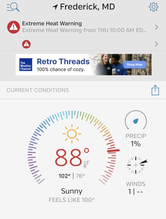
On my way to work passing thru Frederick. Car reads 89 nearby stations confirm it nasty out.


.thumb.jpeg.f5c6ba9d911ec96b3b124f8606aee58e.jpeg)

