All Activity
- Past hour
-
ok so maybe that one was a bust lol
-
Thinking 3 to 5 then some sleet and zr
-
Trending cooler. Maybe the reason why today went to shit can help Friday.
-
Looked better overnight to me. Same reason why today went to shit.
-
12z NAM.has a nice thump here Friday afternoon
-
True, maybe we should look at any Norwegian forecast models?
-
wouldn't be surprised if the season ended in a wimper snowwise. The only saving grace to this season was the big dump on 1/26 and the prolonged cold - great for retention. Best riding season in years. Had it not been for the last good dump and the retention, season would have been very different. This is the time to cash in to build the pack heading into march, but window is starting to close slightly and my interest in big snows start to wane my mid march. We'll see how it shakes out
-

“Cory’s in NYC! Let’s HECS!” Feb. 22-24 Disco
40/70 Benchmark replied to TheSnowman's topic in New England
Yea, hot, steamaing pile of excrement lol -

Late February/Early March 2026 Mid-Long Range
winter_warlock replied to WxUSAF's topic in Mid Atlantic
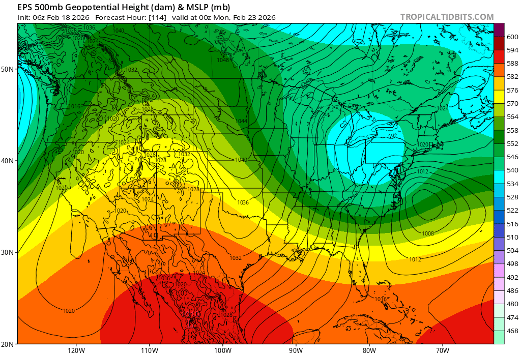
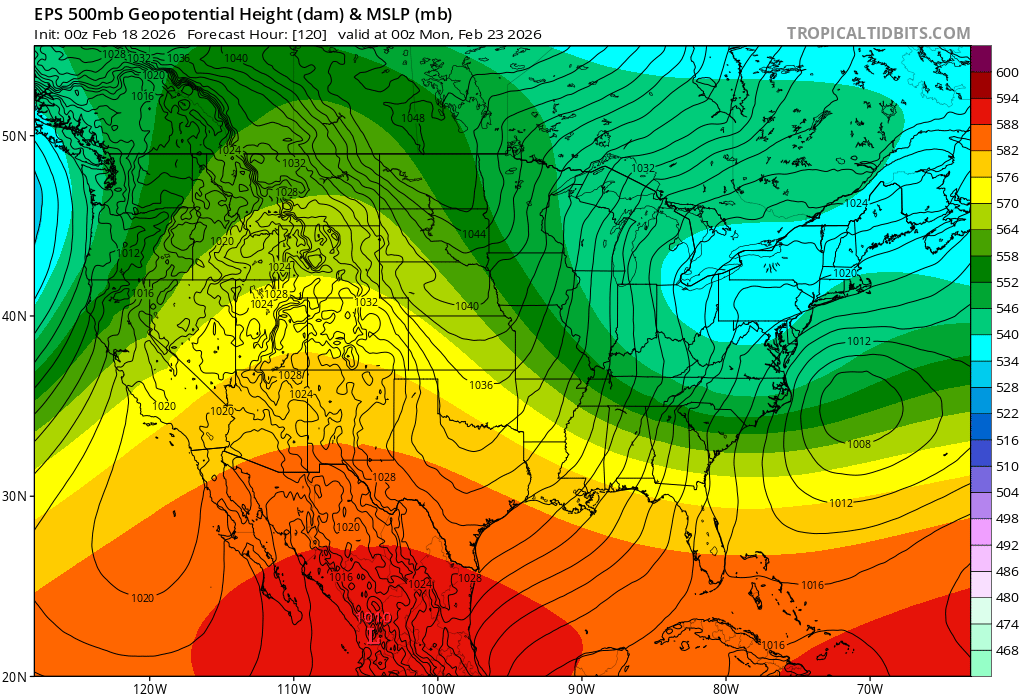
Eps did come nw a bit compared to 00z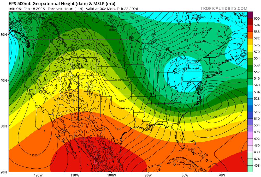

-
What sun? I’ve forgotten what it looks like.
-
They won’t be.
-
I would like to suggest that this thread be closed and have @HoarfrostHubb get the party re-started, since he has the hot hand and well, the accordian guy does not.
-
There are patterns within seasons for sure. But some of this is perception bias and selection bias. For example...your theory this year only works if you ignore the first real snow of the season that missed up just to the north in early December and gave parts of southern/central PA 3-6". Of course places further north would point to that snow in November in upstate NY but do we toss that because the winter pattern had not set in yet? Then yes...later in December those 2 events hit south of us...but I got 5" from a storm during that period also. Which one is the one that becomes the real pattern setter? It's easy in hindsight but that is biased. I am not denying your point about patterns within seasons. There are real tendencies for a seasonal pattern to produce repeating results. In a year like 1996 and 2010 that's great for us. Most years...not. But the issue is...this isn't very useful for predictive measures because of 2 things. 1) You don't know ahead of time when the pattern is starting. 2) You don't know during the pattern when it's going to end. Every pattern breaks at some point. Right now we don't know if that is going to be with this next storm (hopefully) or maybe March or maybe the pattern lasts into Spring and it's too late for us by the time it ends...but without knowing when it ends we can't just say every storm is going to do the same thing.
-
We are at that time of year where the difference in temp between work and my house near the South River can be as much as 10-15F difference. Driving home yesterday, I hit 54F on Rt50 and once I pulled into the driveway at the house, it was 44F. South river was still partially frozen in spots but should be gone in the next few days. Water temp still probably 33-36F though, so the cooler temps in the immediate neighborhoods will probably remain chillier than inland.
-

“Cory’s in NYC! Let’s HECS!” Feb. 22-24 Disco
ineedsnow replied to TheSnowman's topic in New England
6z CMC would have been better but only goes out to hr84 -

“Cory’s in NYC! Let’s HECS!” Feb. 22-24 Disco
Cyclone-68 replied to TheSnowman's topic in New England
Weird that it seems the late evening model trends this winter has been poor but the morning after they rebound a little bit (for ultimately both hits and misses later) Just something this novice has noticed -
Late February/Early March 2026 Mid-Long Range
winter_warlock replied to WxUSAF's topic in Mid Atlantic
So.. 8:1 or 10:1. Doesn't make that much of a difference be glad u get what u get in late February -

“Cory’s in NYC! Let’s HECS!” Feb. 22-24 Disco
RUNNAWAYICEBERG replied to TheSnowman's topic in New England
Shocking development lol… -
“Cory’s in NYC! Let’s HECS!” Feb. 22-24 Disco
40/70 Benchmark replied to TheSnowman's topic in New England
06z GFS appears as though it's struggling with the convection, as it has like 8 different lows. -
Mizzle at 36 degrees in Garwood, NJ.
-
Seasonal numerical forecasting euphoria to the doldrumms . if you go back and check the threats / discussions from Jan 17/18 and the NC storm similar challenges with coastal formation and even some of the same models run to run changes. Each situation is unique and perhaps as we go deeper into the season we can ween off the seasonal trends.
-

Wednesday Feb 18 Mixed event. NOPE …ain’t happenin’
codfishsnowman replied to HoarfrostHubb's topic in New England
Well I am glad I haven't paid much attention because I have seen so many silly posts on social media about this thing and a p/c that's higher than a kite. Friday looks equally as confusing. -
“Cory’s in NYC! Let’s HECS!” Feb. 22-24 Disco
RUNNAWAYICEBERG replied to TheSnowman's topic in New England
One cycle is not a trend…you know this. -
Great trends at 6z
-

E PA/NJ/DE Winter 2025-26 Obs/Discussion
MickeyTim6533 replied to LVblizzard's topic in Philadelphia Region
are you seeing anything that makes you think that?


.thumb.png.4150b06c63a21f61052e47a612bf1818.png)


