All Activity
- Past hour
-
What trend? Stop trolling already. Its not even winter
-
Hippie go' lucky has turned into Taunton West. Where has the optimism gone?
-
waiting for the weenies to call this the feb 20 redux becuase of this noise
-
Can easily miss south, this was consensus yday lol
-
South trend begins
-
Ji had a meltdown because I got caught by a red light yesterday and he doesn't even know me.
-
WB 18Z EPS holds (first picture), its global is a tick east and less intense overall.

-
let’s pray that DIT gets his wish and CT is washed into the Atlantic
- Yesterday
-
-
AI went way south, barely anything here.
-
For once I’ll be out on the island. Looking forward to the carnage!
-
There's still time for this to miss but yeah that's likely wrong
-
Jerry, all alone in the Atlantic, appears to be the Master of his Domain.
-
18z Euro further north better than the boring weather we been dealing with
-
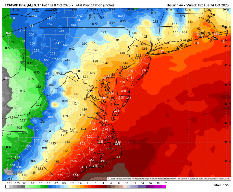
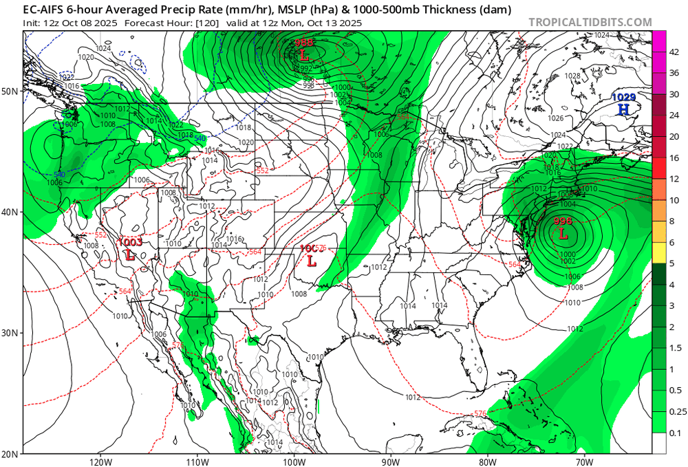
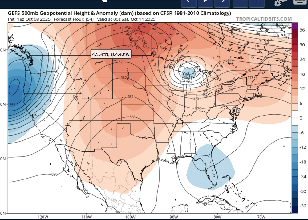
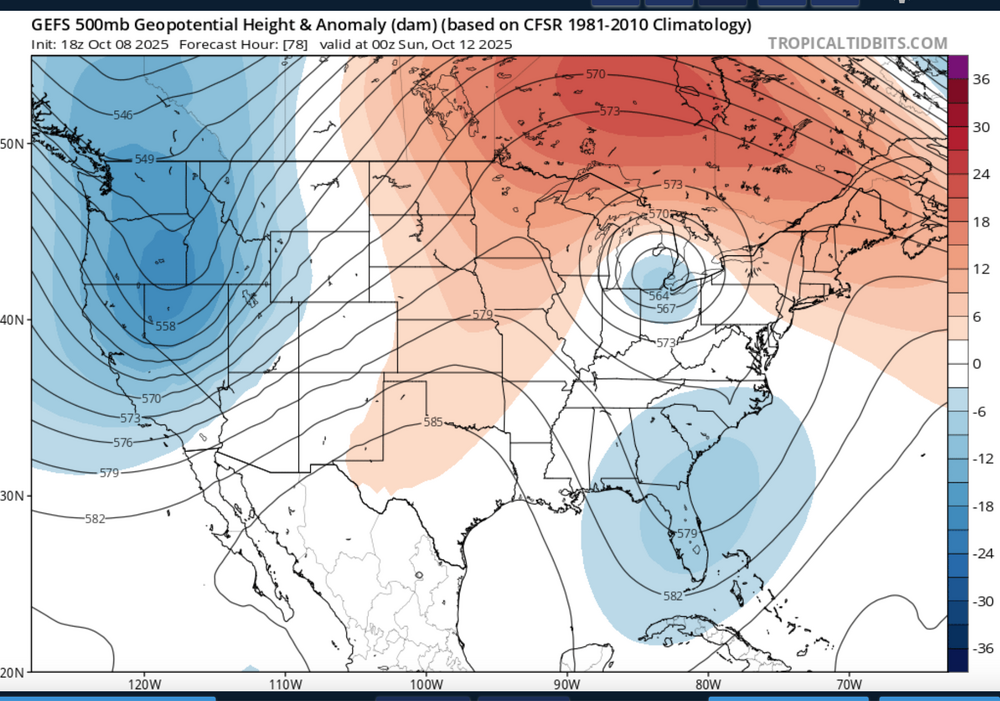
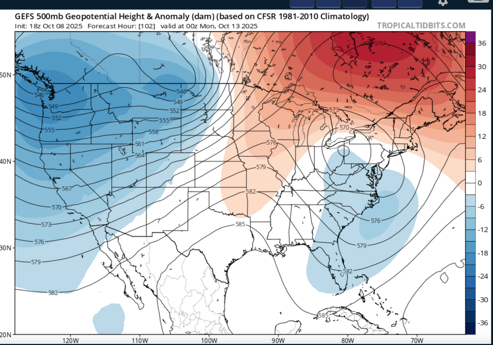
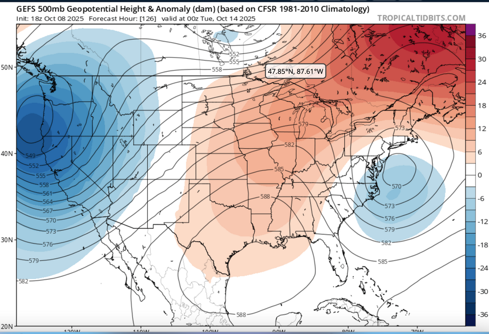
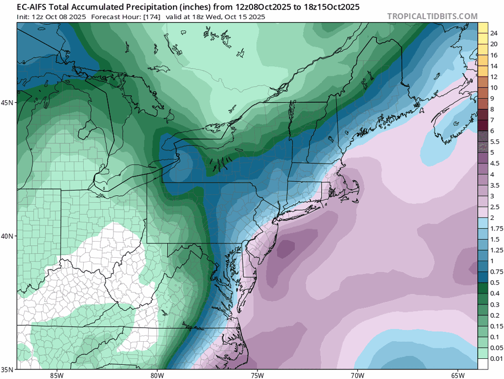
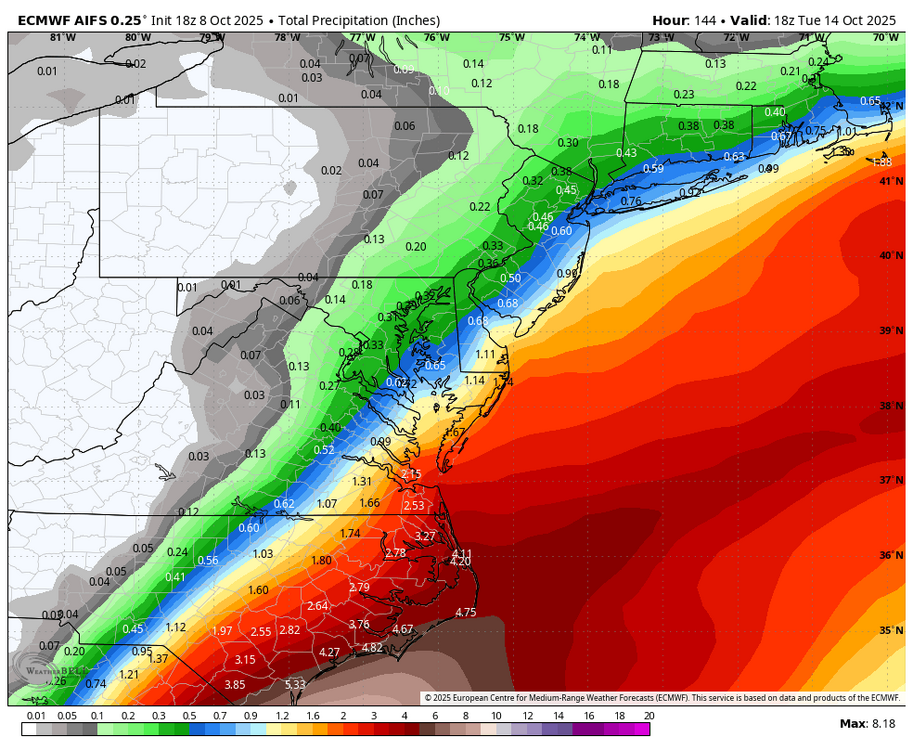
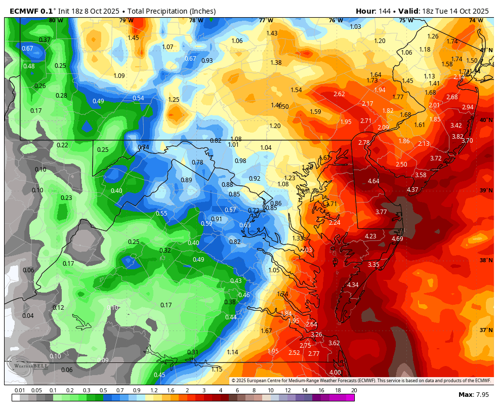
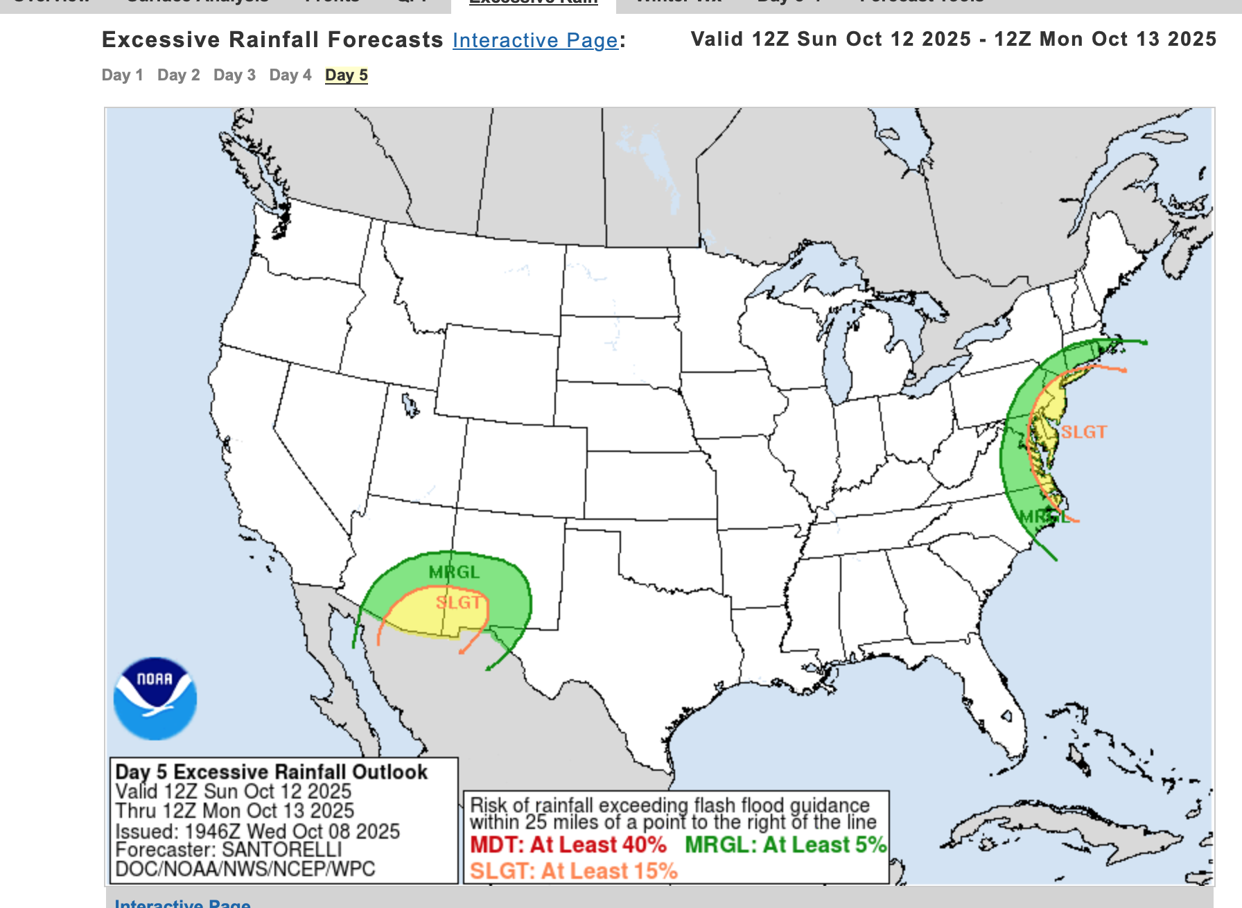
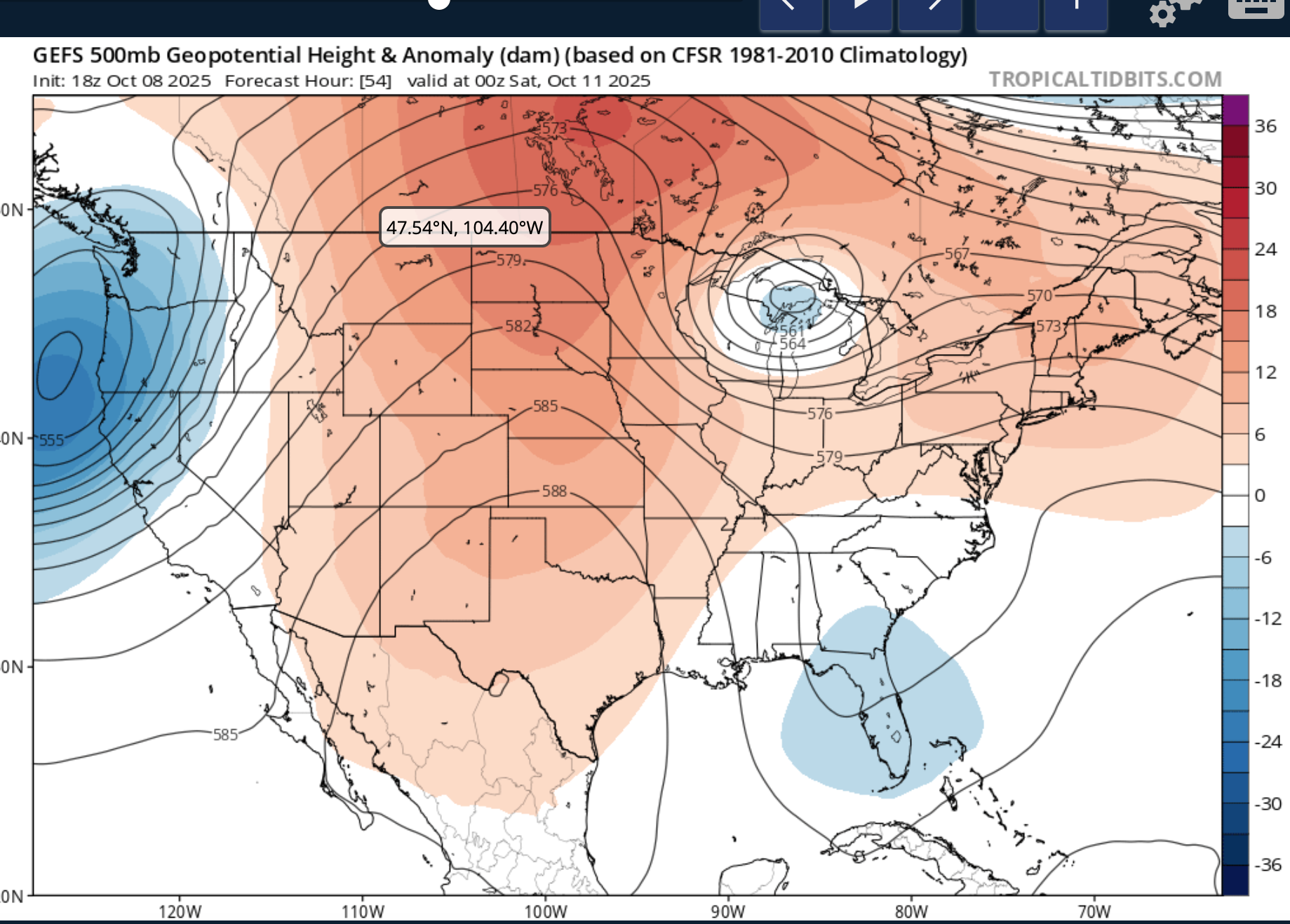
 Nor'easter coming Sunday-Monday though track uncertain ranging from coastal hugger e of NJ worst case scenario to further southeast and less impact. Graphics added are the Wednesday afternoon's WPC 5 day rainfall forecast ending 00z Tue 10/14, The WPC D5 concerns for excessive rainfall issued this Wednesday afternoon - Isolated 4" in the slight risk area but general 1-2" foreseen for much of the NYC subforum between 6AM EDT Sunday and 6AM Tuesday. Also added 4 successive 24 hr forecasts of the evolving 18z/8 GEFS 5H field which I hope repeats this winter... a phaser with a southeastward diving cold core strong short wave through the Great Lakes this weekend that ingests-draws northward - the moist trough currently developing along the se USA coast and results in a fairly intense storm along the mid Atlantic coast by Sunday. The EC EPS 24 hr max wind gust tool has been cyclically consistently offering 60+ MPH in the western Atlantic and 50+ MPH along parts of the NJ-LI coasts. If this occurs, in conjunction with heavy rainfall, fully leaved tree branches would break or even uproot in some locations. No guarantees on wind strength at this time The strong chilly high pressure system that is developing into our area now will become part of a eastern Canada block and set up a strong easterly gradient over our area and should result in multiple cycles of at least minor coastal flooding with a pretty strong potential for at least one high tide cycle moderate coastal flooding (even outlier LOW PROB spotty major) for either the midday Sunday or midday Monday high tide cycle along the NJ coast. Full moon is past us so the astronomical higher tide cycles are lowering and helps reduce the chance of more than moderate coastal flooding. Still this is 4-5 days away, so intensity, track and system evolution are not locked into a worst case scenario and will ultimately determine impacts. Erosion will occur...severity unknown. It appears the ECAI has been most cyclically stable predicting this storm for our NYC subforum dating back to I think the 00z/4 cycle. Did not look at standard deviations departures of the 850 MB inflow but suffice to say, its stronger that normal. PWAT generally near 1.5" minimizes potential for much greater than 4" though the 2" PWAR axis lies just offshore. posted 741PM/8
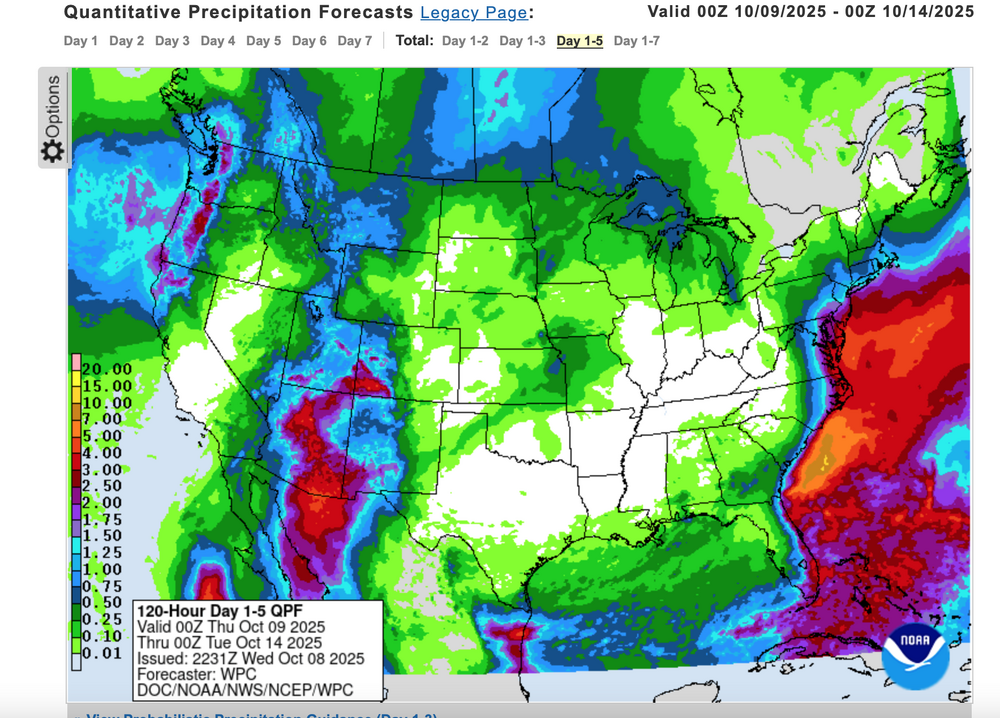

-
- 2
-

-

-
- heavy rain
- damaging wind
- (and 2 more)
-
-
You should see the difference between the 12z EURO AI and the latest 18z run lolol a worthy successor
-
WB 18Z AI is a nothing burger west of the Bay.
-

Spooky Season (October Disco Thread)
Go Kart Mozart replied to Prismshine Productions's topic in New England
gfs has the low approach...then run away like it is afraid of us. -
this is probably the most active i've seen this place since march 2025

-

Mountain West Discussion
mayjawintastawm replied to mayjawintastawm's topic in Central/Western States
Not to split hairs too much, but given COCORAHS and climate reports I'd move the purple and blue boundaries 10 miles or so northwest. Centennial Airport, the nearest climate site around 5 miles SE of the Denver line in Arapahoe County and about 3 miles SE of me, got 1.58" (122% of normal) in September and is at 0.11" so far in October. -
Euro is better down there…briefly >50kt at 925, but I don’t think you’re getting anything crazy for wind with this near the NH border. Should be a stormy day either way though.
-
A last-minute rug pull is always possible with a coastal. It wouldn’t be a bad thing because it would help thicken our skin, in preparation for the inevitable winter storm rug pulls.
-

Spooky Season (October Disco Thread)
HoarfrostHubb replied to Prismshine Productions's topic in New England
Windows closed today. AC running 2 days ago. And so it begins -
The negative IOD is kind of interesting. This is a good article about the IOD and it's effects. The relationship is modeled to weaken over time in the future with some changes to the sst gradients. However, for now and when you eliminate other factors. -IOD seemingly favors -NAO in and of itself if it were the dominating feature. Climate change alters the Indian Ocean Dipole and weakens its North Atlantic teleconnection https://www.nature.com/articles/s43247-025-02131-5


.thumb.JPG.418e8a9a2902ae687ec35ff4bc0e038e.JPG)


.thumb.png.4150b06c63a21f61052e47a612bf1818.png)
