All Activity
- Past hour
-
0.70" of rain yesterday. Looking at gusty winds from the W today with highs near 70. More rain coming Friday. Looks like a general 1/2-1" rainfall across NE MN. We needed that.
-
 reputable canadian online pharmacy and canadian pharmacy service canadian pharmacy service https://www.google.co.zw/url?q=https://northrxcanada.com the canadian pharmacy and https://vintage-car.eu/user/abuknxxfpb/ online pharmacy canada [url=https://www.google.sm/url?q=https://northrxcanada.com]canada drug pharmacy[/url] best canadian pharmacy and [url=https://rightcoachforme.com/author/vsihlaoodz/]canada pharmacy world[/url] cipa canada online pharmacy
 -
mm ...not intending to be involved in any back and forth. I'm not sure that's exactly impossible just hearing the immediate binary exchange there. Heh. Given the empirical setting of Earth ..., we have to objectively be open to a notion that extreme results may be preferentially warm. That almost seems passively comedic put that way... I mean, just because of the nature of having something like a "warmest ever ENSO" taking place over top a CC canvas. Perhaps trampoline is apropos. I was just mentioning to Chris over in the ENSO thread ..the synergistic product cannot really be ascertained. *However*, the probability for that sort of thing one which side of the mean can certainly be intuitive. You and I have set up some pathways to getting a snow this year. Those are still valid. I like the hangover N. Pac idea - although the recent PDO tells me the wind biases may be changing - 'nother headache). Regardless, that's among the less likely outcomes. Given the leading and in situ circumstances the warmer one are weighted. Tough call - don't want to evacuate the probability either because patterns tend to "try" to slip or regress as a real observed phenomenon. You don't just escape and dust off hands. Doesn't work that way. So yeah... that's why I don't mind the pathway.. I could also see this year with something like a STJ that aligns farther N of canonical due to the fact that as has been papered by multiple sources...the westerly bands/jets have been moving N with the CC over recent decades. That immediately assumes a warmer southern tier.. and flooding and rains... with the band of winter shenanigans shifted
-
That is an awfully pathetic look. Is there a global shot for that? I wonder if much of the Arctic cold will end up being displaced on the other side of the hemisphere. Going to take some well-timed airmasses here to really have a good chance to cash in
-
Nice, nice baby
-
I'm more confident of a KU for the mid atl than I am here...the pressing of the Canadian ridge is a concern.
-
canada drug pharmacy [url=http://northrxcanada.com/#]canadian pharmacy reviews[/url] :: canadian online pharmacy
-

2026-2027 Record-breaking El Nino
GaWx replied to Stormchaserchuck1's topic in Weather Forecasting and Discussion
JAMSTEC Sept ‘26 Nino 3.4 forecast (this is NOT relative): mean is stronger than recent CFSv2 (though CFSv2 updates more recent since their updates are much more frequent) and mean cools more slowly, too, especially into Jan: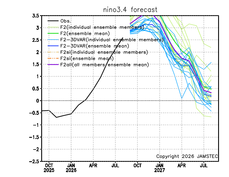
-
Monday through Thursday I don't have a forecast high above 70.
-
(002).thumb.png.6e3d9d46bca5fe41aab7a74871dd8af8.png)
Central PA Summer 2026 Discussion/Obs Thread
ChescoWx replied to Voyager's topic in Upstate New York/Pennsylvania
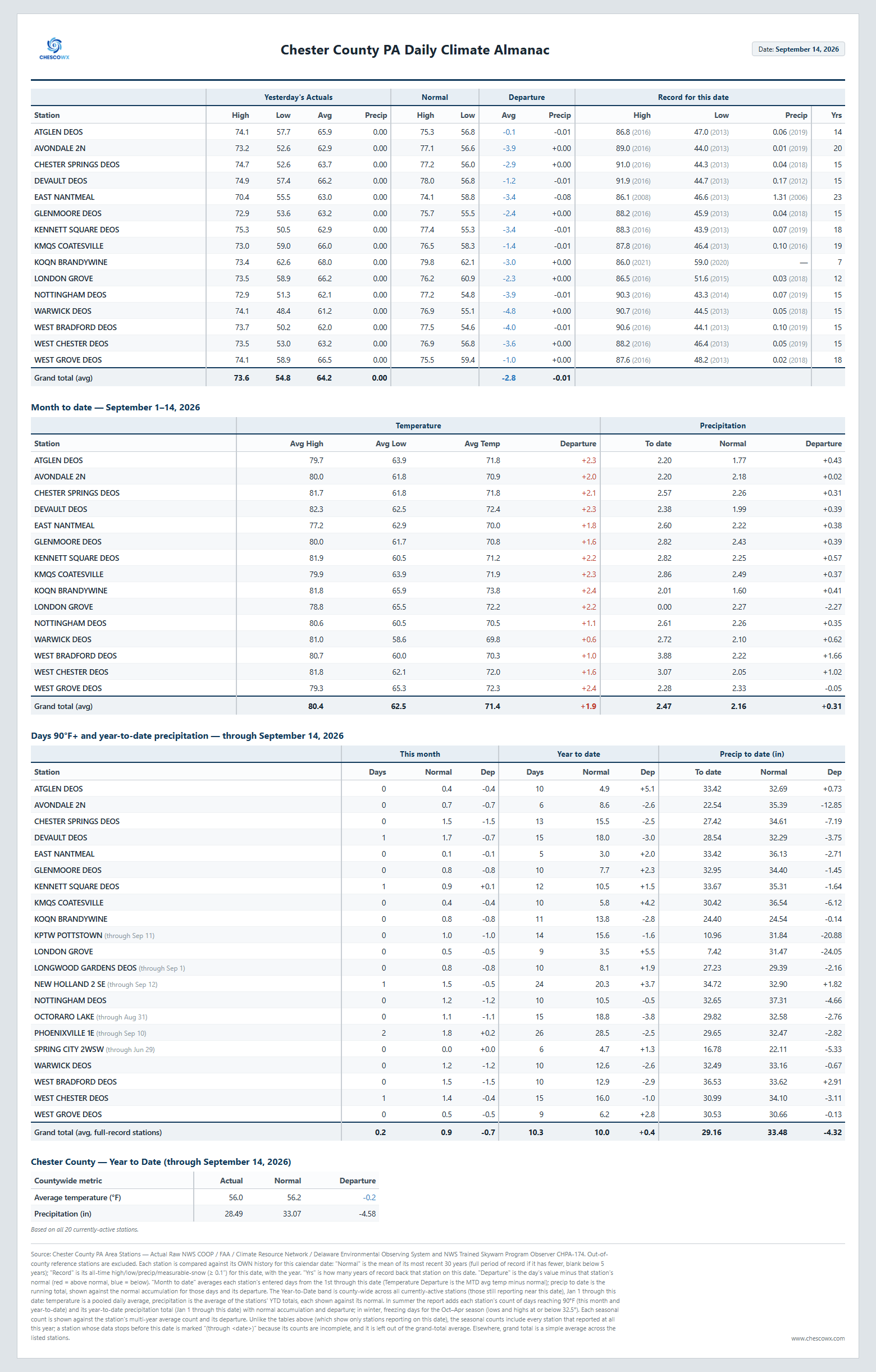
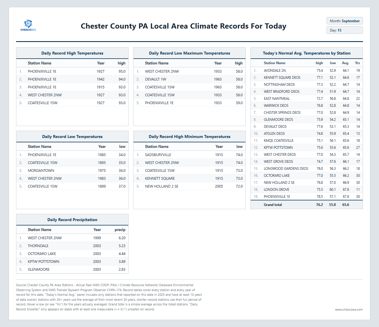
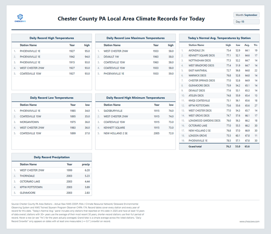
Plenty of 40's for lows this AM across the area with our overall chilliest morning since back on June 2nd. The coldest reading was the 42.7 at Warwick DEOS. Below normal temperatures look to continue today before we start a warming trend that peaks on Thursday before we turn cooler again for the weekend and looking ahead we see some unseasonably chilly air by early next week. Highs may not get to far above 60 degrees for some of the higher spots by next Tuesday. Our next rain chances hold off till Sunday.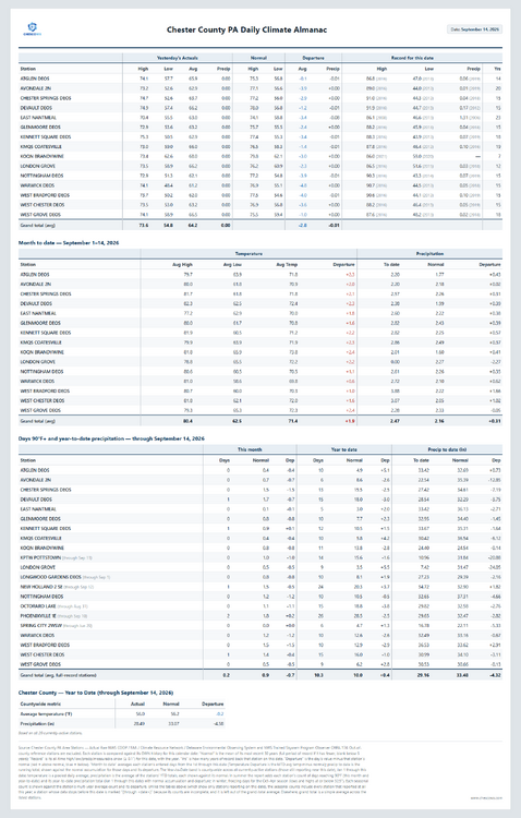
-
E PA/NJ/DE Autumn 2026 Obs/Discussion
ChescoWx replied to PhiEaglesfan712's topic in Philadelphia Region
Plenty of 40's for lows this AM across the area with our overall chilliest morning since back on June 2nd. The coldest reading was the 42.7 at Warwick DEOS. Below normal temperatures look to continue today before we start a warming trend that peaks on Thursday before we turn cooler again for the weekend and looking ahead we see some unseasonably chilly air by early next week. Highs may not get to far above 60 degrees for some of the higher spots by next Tuesday. Our next rain chances hold off till Sunday.
-
53.2 here this morning
-

Septorcher 2026 Discussion - Endless Summer
kdxken replied to Damage In Tolland's topic in New England
Don't start. -
He trolls. Fully expect at least 1 KU. Could be the busiest season with extremely tough forecasts.
-

Septorcher 2026 Discussion - Endless Summer
Brewbeer replied to Damage In Tolland's topic in New England
up to a torchy 60/49 -
Was at URI 92 to 94 walking around was brutal. The wind and cold in 93 was constant
-
Not happening at this latitude.
-

Septorcher 2026 Discussion - Endless Summer
Ginx snewx replied to Damage In Tolland's topic in New England
Nah we always have that 1 October day -

2026-2027 Record-breaking El Nino
Typhoon Tip replied to Stormchaserchuck1's topic in Weather Forecasting and Discussion
Yeah Chris ...I agree ...I added that exact aspect to that post -
53 low. Pretty good for the lowlands. Downright pleasant.
- Today
-

2026-2027 Record-breaking El Nino
bluewave replied to Stormchaserchuck1's topic in Weather Forecasting and Discussion
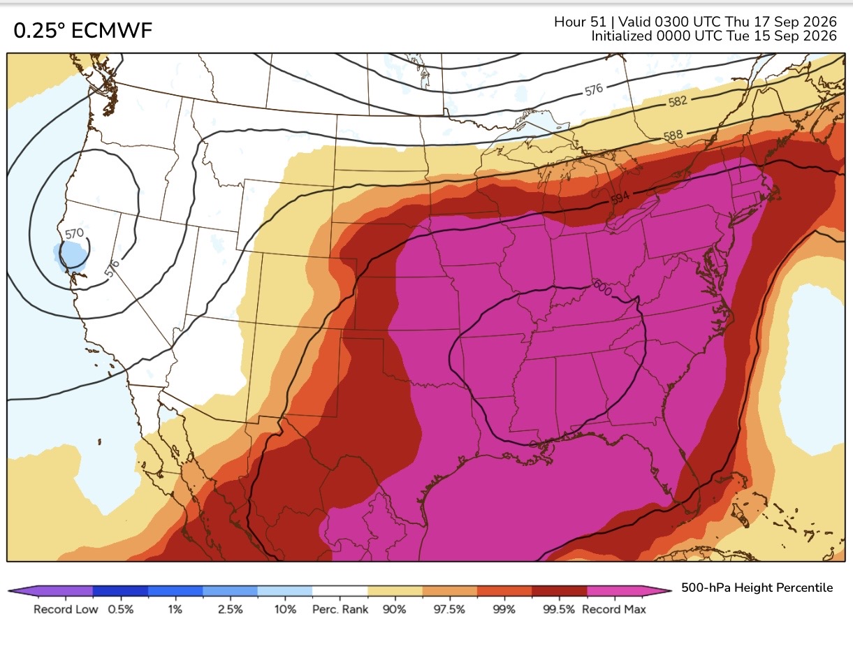
Even single model forecasts have been missing the magnitudes of the ridges and the warmth underneath. But this is to be expected due to the much lower resolution and nature of long range forecasts beyond 15 days. In our rapidly warming climate there have been many more opportunities for the models to be biased too cold than too warm. So it’s beyond technology of present day weather forecast models to have been able to see the historic 600 dm ridge this week from beyond 5-10 days out.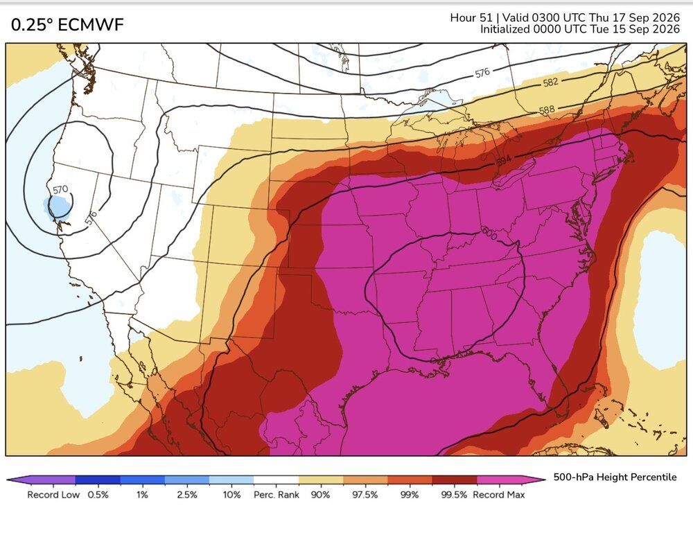
-
https://northrxcanada.com/# canadian pharmacy rx
-

2026-2027 Record-breaking El Nino
LakePaste25 replied to Stormchaserchuck1's topic in Weather Forecasting and Discussion
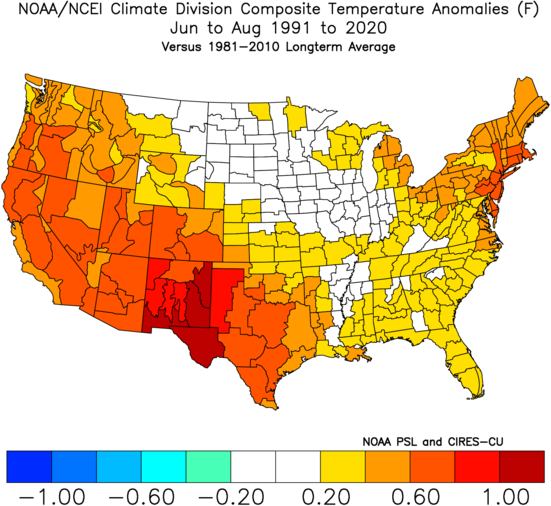
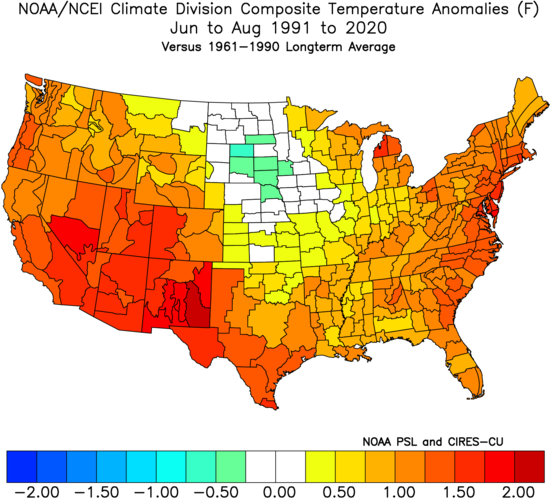
This was essentially just a slightly east-shifted version of the long term trends of summer in CONUS. The strongest El Niño on record was unable to shake it.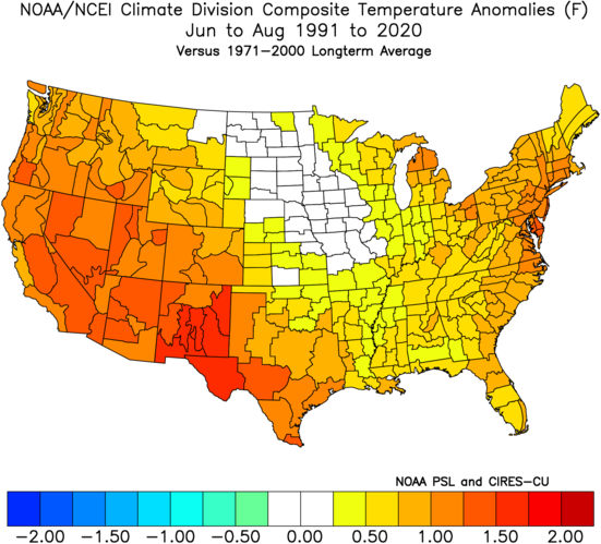
-
50.9 in Muttontown & 52.5 in Syosset for lows this morning.
-
2026-2027 Record-breaking El Nino
Typhoon Tip replied to Stormchaserchuck1's topic in Weather Forecasting and Discussion
stating the obvious... any "blend" technique is always going to miss the extreme, unless every member contributing to the mean are unilaterally nailing the result/coincidentally. Since this is never going to be the case, the interquartile members that are middle road and less so, are always offsetting - basic stats. Hence, blend missing the extremes in the west. But part of that is also not really attainable anyway? I don't believe so. Because the heat in the W was very synergistic in nature. It's basically combing a handful of inputs that are going to likely gestalt some gain that cannot really be preascertained. That's how synergistic emergence is... it can't be mathematically predicted in excessively complex systems - at least not yet. Maybe QC will have a say in that some day. But we have the perennial N/A western bulge in the westerlies, on top of a retrograde IA CGT hemisphere, on top of a terrain that promotes heat and then a subsequent bi-product of that is that the heat in turn bulges heights... on top of then even a kind of non-Markovian feedback when the quantum state of the whole system acts like it "wants" to be hot due to memory from aggregate occurrences... Those are some of the parts that are creating an outcome > then just their sum. I guess what I'm asking is, taking out the more extreme/warmest members contributing to any blend, I suspect even those were shy of the scalar ?