All Activity
- Past hour
-

26th-27th event, coming at us like a wounded duck.
Damage In Tolland replied to Go Kart Mozart's topic in New England
Nammy with the sleet into NYC idea. Remember how well it sniffs out the warm tongue at 925 -

26th-27th event, coming at us like a wounded duck.
Fozz replied to Go Kart Mozart's topic in New England
If this storm actually delivers for SNE, then the ICON will deserve lots of kudos. For days the ICON was alone in seeing this, but can’t celebrate just yet. -
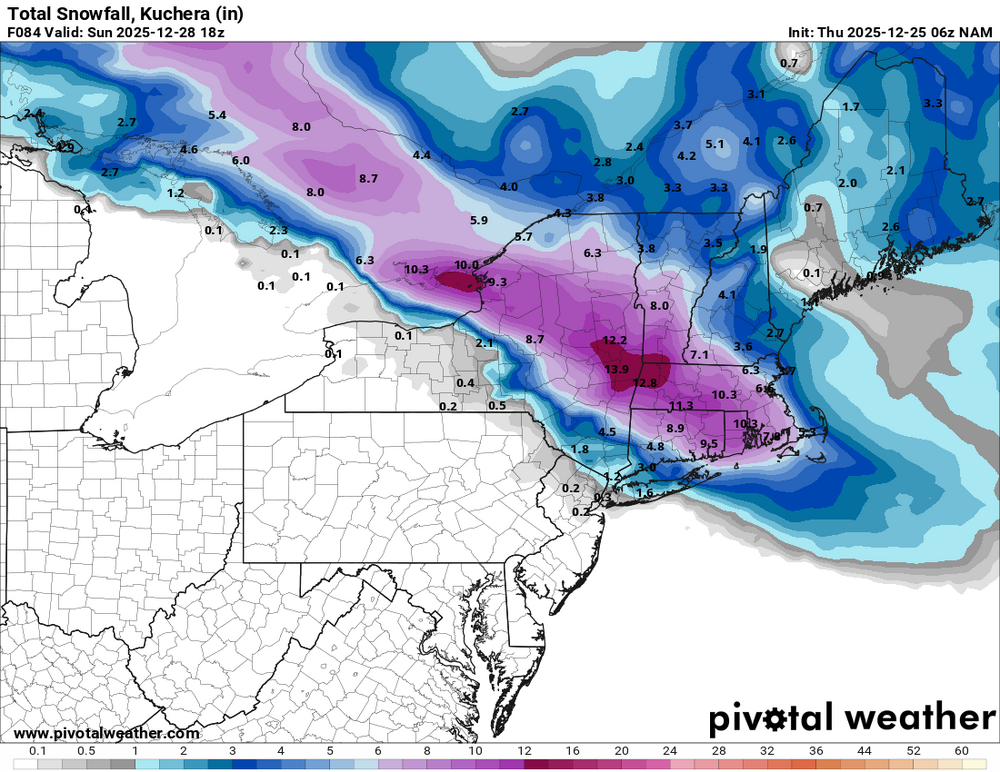
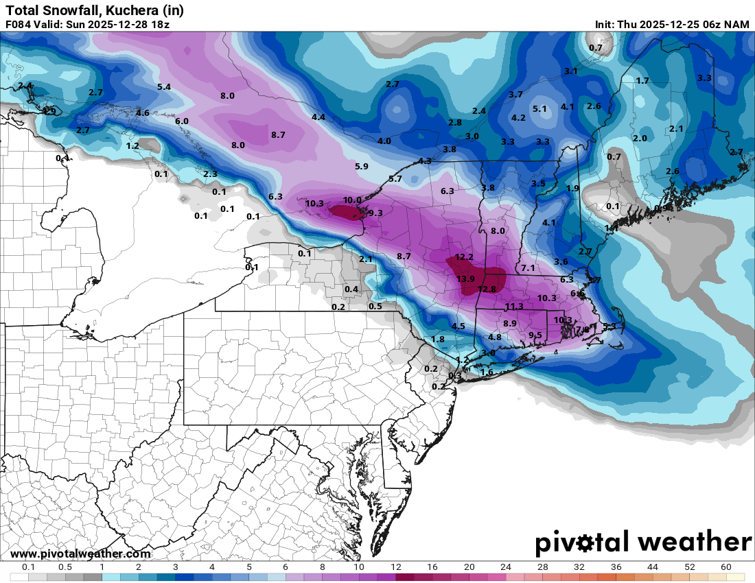
The 6z hi res RGEM and the 6z 3K and 12K NAM runs are showing a strong mid-level warm nose all the way up into Rockland, Orange, Sussex, Passaic and Bergen. The Ptype goes to a sleet fest. This should be taken seriously due to the fact this is a WAA event
-

26th-27th event, coming at us like a wounded duck.
TauntonBlizzard2013 replied to Go Kart Mozart's topic in New England
Looks like we got head faked at 00z. 6z kind of settled back -
RGEM not being amped is a big sign too. I really think it's just going to be a wall of snow that quickly drops several inches and then when rates lessen it turns to sleet/zr
-
Icon
.thumb.png.212a6b28779098583451c245c4ad3b40.png)
-
Gfs looks great. HRRR also.
-
If this couples with the troposphere, we have issues next month. The SPV is about to strengthen rapidly, become quite strong, consolidate and move up over the pole. We haven’t had coupling so far and we didn’t last winter, but that doesn’t mean it can’t change. Different QBO evolution this year. This is something to watch very closely
-

26th-27th event, coming at us like a wounded duck.
Ginx snewx replied to Go Kart Mozart's topic in New England
Merry Christmas to you. Yea all over the place. Bottom of trough weakens boom -

26th-27th event, coming at us like a wounded duck.
Modfan2 replied to Go Kart Mozart's topic in New England
Merry Christmas! As usual, will become a nowcast event. -
26th-27th event, coming at us like a wounded duck.
Ginx snewx replied to Go Kart Mozart's topic in New England
Euro with ratios ! We got Nam'ed big time, GFS back south. Big camp splits. Who knows?.png.c84cfa8b6949b8056ef515cb55b03177.png)
.png.4c15945a1a8cfbff159437e7bdd109fb.png)
.thumb.png.431350570207011aa0e7fd2cddbf8e73.png)
.thumb.png.61097fcfe8ecc8242d0f06a8d64782c0.png)
-
Thunder woke me up this morning in WV…
-
06z GFS not going for the north trend and looks reasonably similar to previous GFS runs.
- Today
-
Mt holly is going to bust badly if they dont start following the modelling
-
We could become roommates.
-
Well now here it comes on the 00z 12/25 EPS. Pacific jet extends, wave breaks that semi-permanent pacific block, +PNA setting up. Merry Christmas
-
I hope not for your sake as well.
-
When I’m your age i hope i don’t get up this early.
-
And a Merry Christmas to you!
-
Yeah looks like a big sleeter south of NYC. A few more nudges north (not even including the storm will probably be under modeled as to the northern extent of the sleet because this is a SWFE yet) and sleet will probably be quite prevalent in NYC. I’d cut the totals from CNJ on south in half.
-

2025-2026 Fall/Winter Mountain Thread
ncjoaquin replied to Buckethead's topic in Southeastern States
A very good article on Dr. Frank, in case you didn't see it. https://www.khou.com/article/news/local/dr-neil-frank-dies/285-26cc29fe-18ee-4e47-bdf3-5039367c021a -
The NWS offices in Philly and NYC kind of punted, lol, keeping all of the watches up and not reducing snowfall forecasts much in the updated map vs. yesterday afternoon's map, other than trimming back a bit near 276/195 and in EPA and on LI, although their discussion talks about reduced snowfall due to more sleet in the W/SW counties that have watches and due to more rain possible for the SNJ counties that have watches. Hard to blame them as there's still almost 36 hours before the event starts and this way they don't have to change twice.
-
Come on. It's against forum rules to quote anything Mr. G. says.
-
6z NAM is still dogwater. On my phone at work. Otherwise I’d post the images.


.png.3f3e5e5fd3c13520c14748723102645c.png)


.png.104f8ee1319ff07f548dc008c034ec95.png)
.png.ce93fc164d922604e06e914fc026d802.png)


