All Activity
- Past hour
-
Records: Highs: EWR: 80 (2021) NYC: 80 (1969) LGA: 80 (2021) JFK: 81 (1969) Lows: EWR: 31 (1974) NYC: 31 (1974) LGA: 32 (1972) JFK: 33 (1974) Historical: 1770 - An exceedingly great storm struck eastern New England causing extensive coastal damage from Massachusetts to Maine, and the highest tide in 47 years. (David Ludlum) 1770: An exceedingly great storm struck eastern New England causing extensive coastal damage from Massachusetts to Maine, and the highest tide in 47 years. 1835: 6.0 inches of snow fell at Ft. Snelling, MN. (Ref. AccWeather Weather History) 1940: The earliest snow greater than one inch in Washington, DC, fell on October 20, 1940 with 1.4 inches and the second earliest greater than one inch was October 30, 1925 with 2.2 inches. (Ref. Washington Weather Records - KDCA) (Ref. October Snows by Herb Close) 1952: Central Park in New York City had their earliest measurable snowfall with a half inch falling. (Ref. Wilson Weather History) 1983 - Remnants of Pacific Hurricane Tico caused extensive flooding in central and south central Oklahoma. Oklahoma City set daily rainfall records with 1.45 inch on the 19th, and 6.28 inches on the 20th. (17th-21st) (The Weather Channel) 1987 - Cold arctic air invaded the Upper Midwest, and squalls in the Lake Superior snowbelt produced heavy snow in eastern Ashland County and northern Iron County of Wisconsin. Totals ranged up to 18 inches at Mellen. In the western U.S., the record high of 69 degrees at Seattle WA was their twenty-fifth of the year, their highest number of record highs for any given year. Bakersfield CA reported a record 146 days in a row with daily highs 80 degrees or above. (The National Weather Summary) (Storm Data) 1988 - Unseasonably warm weather continued in the western U.S. In California, afternoon highs of 96 degrees at Redding and Red Bluff were records for the date. (The National Weather Summary) 1989 - Forty-nine cities reported record low temperatures for the date as readings dipped into the 20s and 30s across much of the south central and southeastern U.S. Lows of 32 degrees at Lake Charles LA and 42 degrees at Lakeland FL were records for October, and Little Rock AR reported their earliest freeze of record. Snow blanketed the higher elevations of Georgia and the Carolinas. Melbourne FL dipped to 47 degrees shortly before midnight to surpass the record low established that morning. Showers and thunderstorms brought heavy rain to parts of the northeastern U.S. Autumn leaves on the ground clogged drains and ditches causing flooding. Up to 4.10 inches of rain soaked southern Vermont in three days. Flood waters washed 600 feet of railroad track, resulting in a train derailment. (The National Weather Summary)(Storm Data) 1994: 1994 The rampaging San Jacinto River (20 feet+ higher than normal) caused 8 pipelines carrying various petroleum products to rupture near Houston, TX; the river ignited in flame and smoke which shot 100s of feet into the air. More than 500 (mostly minor) burn/inhalation injuries. (Ref. Weather Guide Calendar with Phenomenal Weather Events 2011 Accord Pub. 2010, USA) 1996: New Englandwas in the middle of a four day nor'easter which dumped tremendous rainfall totals, especially over eastern sections. 19.19 inches of rain fell at Camp Ellis, ME. 13.03 inches was recorded at Newburyport, MA. Portland, ME set a new all-time 24 hour rainfall record with 13.32 inches. Other rainfall totals included 17.21 inches at Sanford, ME, 12.23 inches at Portsmouth, NH, 11.21 inches at Bedford, MA, and 7.89 inches at Boston, MA. The storm tapped moisture from Hurricane Lili, far to the southeast over the Atlantic, which contributed to the excessive rainfall. The nor'easter also produced high winds along coastal sections. A wind gust to 81 mph was recorded at Little Compton, RI. One person was killed and total damage was over $50 million dollars.(Ref. Wilson Weather History) (Ref. AccWeather Weather History)
-
I'm not well versed on Pacific or Indian Ocean teleconnections. Just trying to learn how the PNA/PDO/EPO all mesh together. Interesting. I'm happy to see some kind of persistent western ridge in Canada. At least that mitigates the Pacific Puke to some degree. Thank you for the insight. I appreciate it.
-
57 / 37 continue with this amazing stretch for this time of the year. Warmer day today with max into the low 70s in the warm spots otherwise mid - upper 60s. Mainly dry and the onshore keeps it cooler on and along the coast and warmer inland. Thu and next Mon look like next warmer days low - mid 70s in the warmest spots otherwise 60s and clear very california like stretch. Outside another cutoff low it looks mainly dry through the 30th. Overall near / slightly above normal beyond there mainly by a majority of days +2 to +5 with a few at or -2. Nie opportunity to dry things out.
-
Not mad at it. Keep November misery away for as long as we can.
-
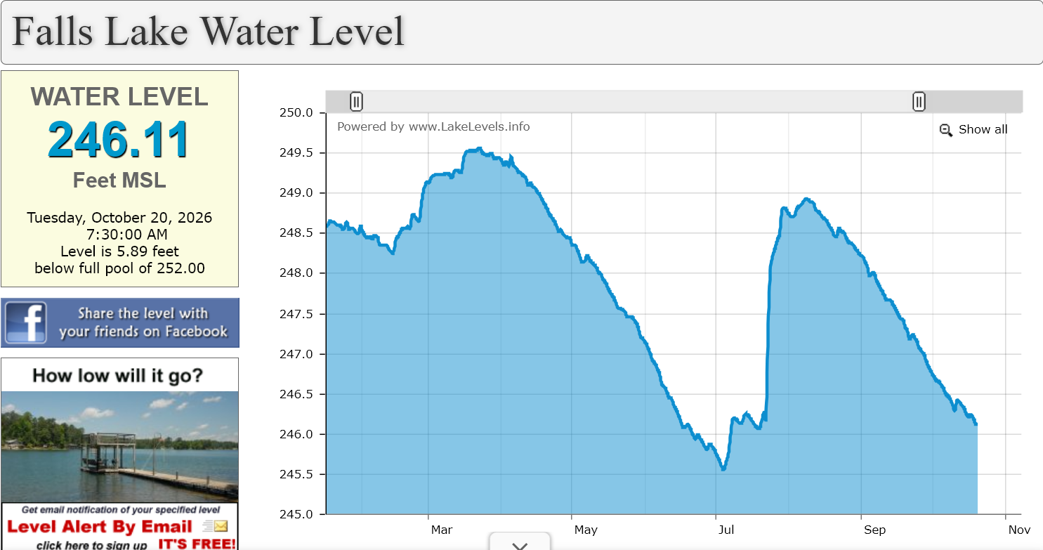
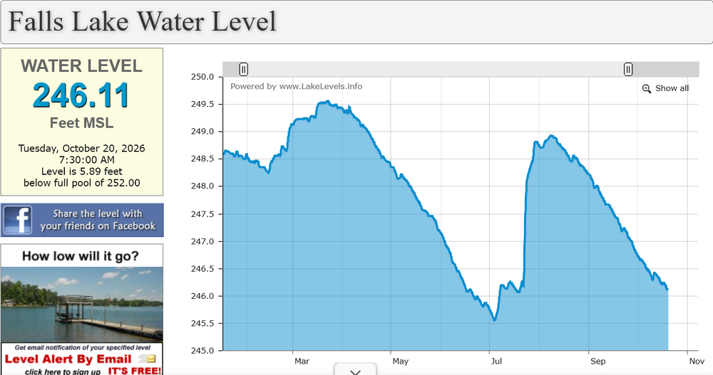
This is a better depiction of the lake level without previous years shown. It is on the way to the lows we saw over the summer once again and this week at least looks completely dry.
-
Low of 28F, as we speak, at 300 feet ASL, Connecticut River Valley.
-

2026-2027 Record-breaking El Nino
40/70 Benchmark replied to Stormchaserchuck1's topic in Weather Forecasting and Discussion
My expectations are low, but not that low..I'll take the over on both of those seasons for snowfall at my locale..especially 2023...1997 will be close. There are pretty clear differences that have been discussed which should cause this season to behave differently than those ones later in the season. That said, early season will probably be worse. I expect a quick recovery after that block... -
Yup, this is the point, and of course there is variability depending on what trees there are, or that one has in their area. If you have alot of, or predominantly oaks where you live, it’s gonna be dull for the most part. If you have more maples and birches…then it will be so much more colorful. It doesn’t mean the foliage is a dull year(of course it can be some years), just means you don’t have the colorful trees in that area.
-
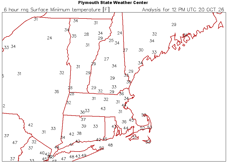
Colder at MHT than MWN this morning
-
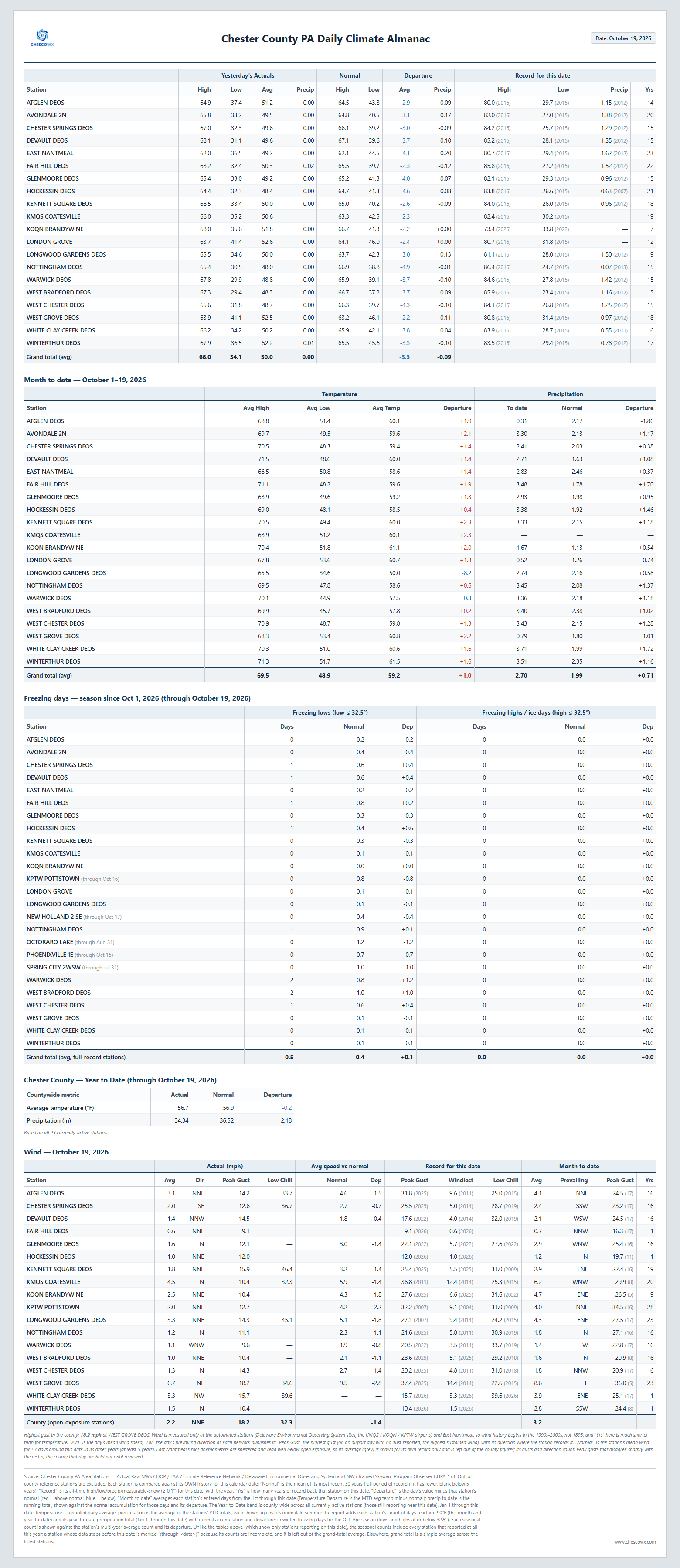
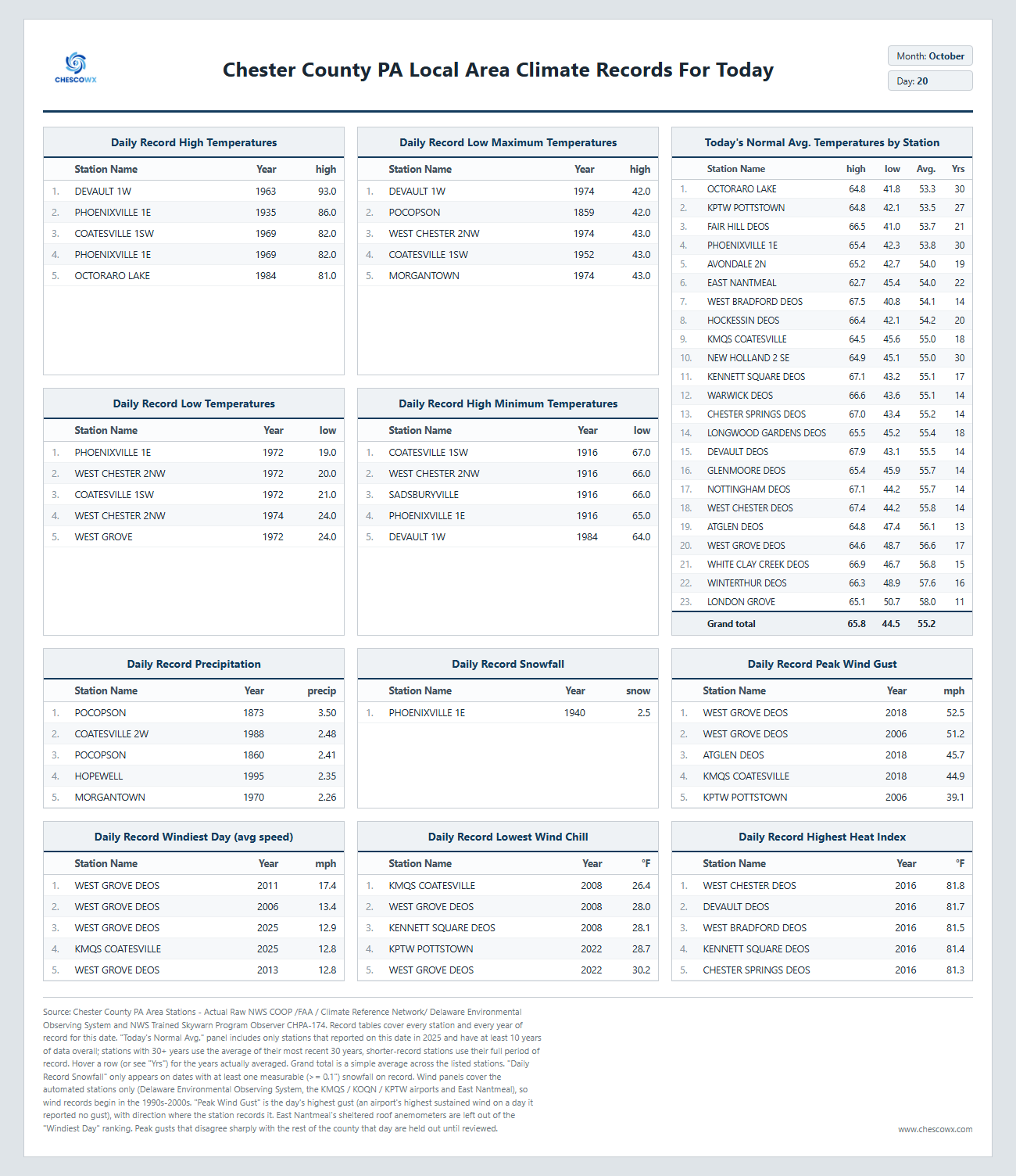
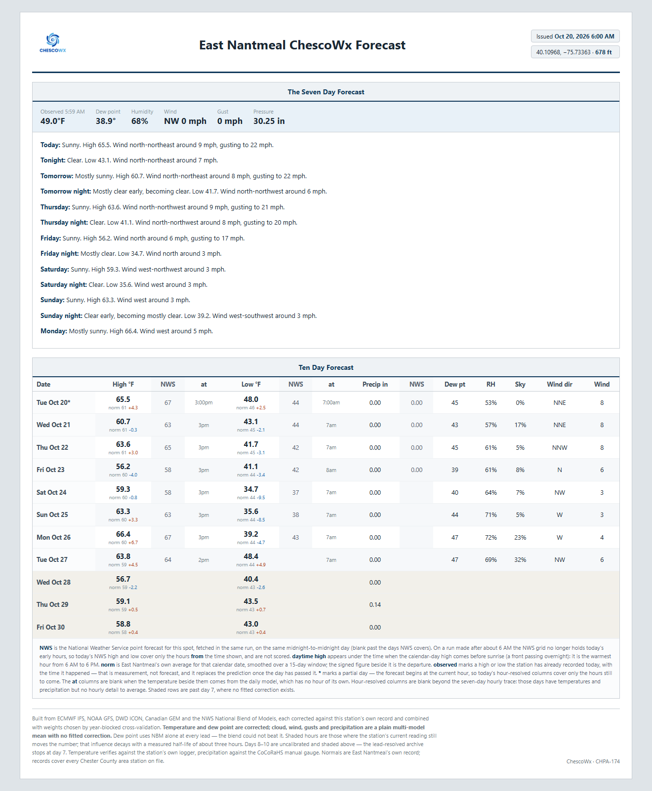
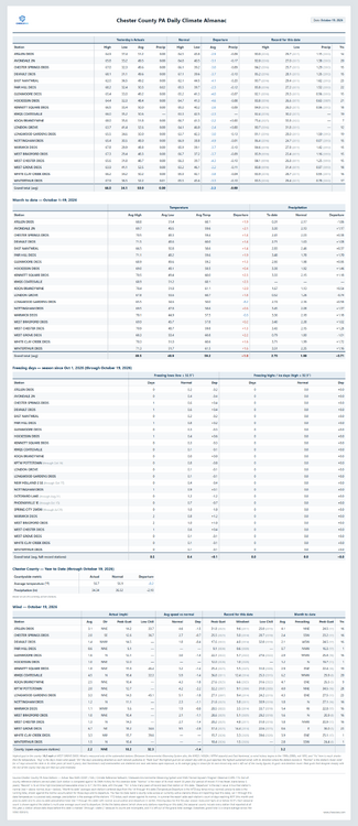
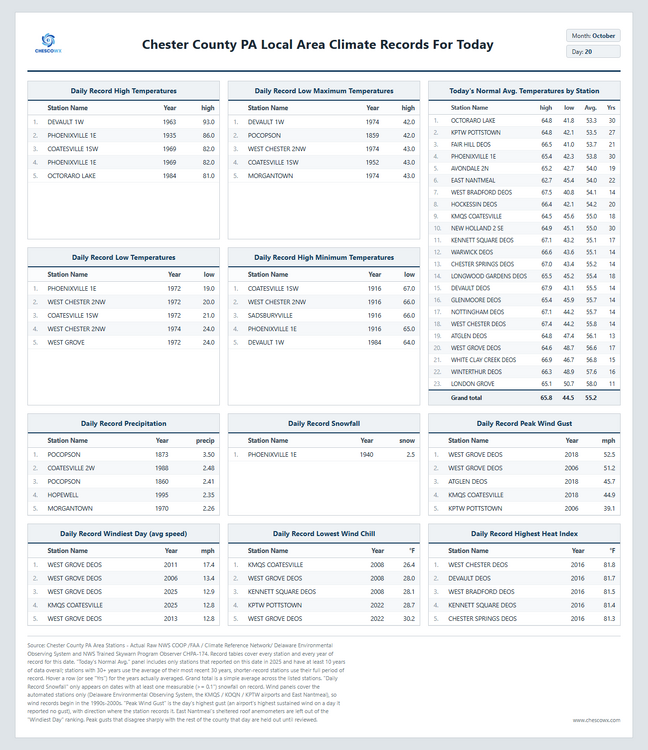
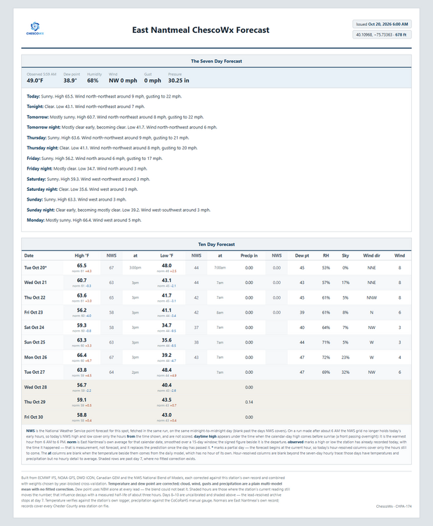
Today we should see highs from mid 60's in ridge locations to the low 70's in valley spots with lows tonight in the upper 30's to low 40's. It should be one of the better weather weeks of the year with almost no chance of rain. By Saturday morning we should see lows in the low to mid 30's with a freeze possible in the colder valleys! Temperatures will be near normal through Thursday but by Friday we drop to about 5 degrees below normal, before we return to near normal by Sunday. Of note 7 years ago today back in 2019 Chester County was at the start of a 3 day storm that left as much as 1.56" of rain at Coatesville 1E. This was the remnants of Tropical Storm Nestor which tracked within about 190 miles of the county.
-

2026-2027 Record-breaking El Nino
bluewave replied to Stormchaserchuck1's topic in Weather Forecasting and Discussion
We are just going to have to wait until we get through December and January to see what happens in February. The issue with the seasonal models is that they default to an El Niño climatology package in February which incudes many weaker events. 2023-2024 and 1997-1998 didn’t necessarily follow the typical February climatology. This event is much stronger than both of those so we should probably keep expectations low and if we do better than those two years in February it’s a nice surprise. -

E PA/NJ/DE Autumn 2026 Obs/Discussion
ChescoWx replied to PhiEaglesfan712's topic in Philadelphia Region
Today we should see highs from mid 60's in ridge locations to the low 70's in valley spots with lows tonight in the upper 30's to low 40's. It should be one of the better weather weeks of the year with almost no chance of rain. By Saturday morning we should see lows in the low to mid 30's with a freeze possible in the colder valleys! Temperatures will be near normal through Thursday but by Friday we drop to about 5 degrees below normal, before we return to near normal by Sunday. Of note 7 years ago today back in 2019 Chester County was at the start of a 3 day storm that left as much as 1.56" of rain at Coatesville 1E. This was the remnants of Tropical Storm Nestor which tracked within about 190 miles of the county.
-
Interesting they blew before this week. It's not super warm up high on North Ridge but it's probably still in the low 50s with full sun. Later this week some cloud cover works it's way in overnight and might not get the wetblub they need to blow more. I got a ticket for 11/15 as I'll be up there with some friends for the weekend. Would be my earliest lift serve day in several seasons.
-
Incredible temperature variance due to cold drainage this particular morning... Cold drain and uneven distribution by dawn isn't in and of itself very unusual, but varying 20 F over short distances, is. It is occurring among a lot of the non-standard NWS sites in the interior. ORH was 43 for a low, now 52... Same in Sterling and N. FIT ... yet, it's 31F at the Oxbow site along Rt 2... Interesting Some of these chillier sites are likely to see a 20 to 25 F bounce this morning.
-
2026-2027 Record-breaking El Nino
LakePaste25 replied to Stormchaserchuck1's topic in Weather Forecasting and Discussion
Not going to lie, it’s frustrating to not see the pattern materialize as I think it’s causing false hope that will ultimately get crushed and creating opportunities for grifting -
A lot of us have been in the main ENSO thread.
-
Two mornings in a row of 39 degrees. Got to 39.9* at 739am today. I am def liking this wx over last weeks.
-
 ed online meds or best online ed pills cheap ed medication https://www.spsi.biz/Redirect.aspx?destination=https://vigorshieldrx.shop/ best ed pills onlineor http://asresin.cn/home.php?mod=space&uid=1310625 what is the cheapest ed medication [url=http://j.lix7.net/?http://vigorshieldrx.shop/]cheap ed[/url] best online ed medicationand [url=http://ussher.org.uk/user/izegymoomq/?um_action=edit]cheapest online ed treatment[/url] ed medications cost
-
https://sildenrxexpress.com/# viagra canada
-
Not excited about 38 degree rain storms? lol
-
Clots are no joke man. I was diagnosed three years ago with a DVT in my calf, and a PE as I had multiple clots in my lungs. Spent three days in the hospital and wondered what if I never made it there? Scary situation. I will be on thinners for the rest of my life and even though I have full movement, my leg still has swelling. Hopefully Hurts can get off thinners and resume his football career, but it might be the end of it in Philly. Went to the Flyers game last night. They looked like they had a little more giddy up on the ice than the first 6 games.
-
Living in an Oak forest and folks can understand why I want a full blowdown here. Take them all. Last year had zero acorns. This year the small acorn trees masted but all the acorns came down in the Nor’easter. None since thankfully
-

2026-2027 Record-breaking El Nino
SnoSki14 replied to Stormchaserchuck1's topic in Weather Forecasting and Discussion
Last November told the story of the coming winter. We'll see if this year November does the same. -
2026-2027 Record-breaking El Nino
40/70 Benchmark replied to Stormchaserchuck1's topic in Weather Forecasting and Discussion
Right, I'm not saying it's the "golden ticket" for winter, but it certainly doesn't hurt...this also ties into what I am talking about in the northern Pacific later in the season. Not to mention that this particular block in unprecedentedly strong as modeled. -
2026-2027 Record-breaking El Nino
bluewave replied to Stormchaserchuck1's topic in Weather Forecasting and Discussion
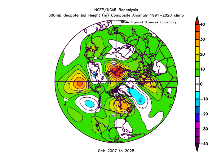
These October Ural to Scandinavian blocks have become the new normal especially in October in the low Arctic sea ice era since 2007.