All Activity
- Past hour
-
Point click is lovely Saturday Night Snow. The snow could be heavy at times. Low around 12. Chance of precipitation is 90%. Sunday Snow. High near 19. Chance of precipitation is 100%. Sunday Night Snow likely, mainly before 1am. Mostly cloudy, with a low around 13. Chance of precipitation is 60%.
-

Central PA Winter 25/26 Discussion and Obs
MAG5035 replied to MAG5035's topic in Upstate New York/Pennsylvania
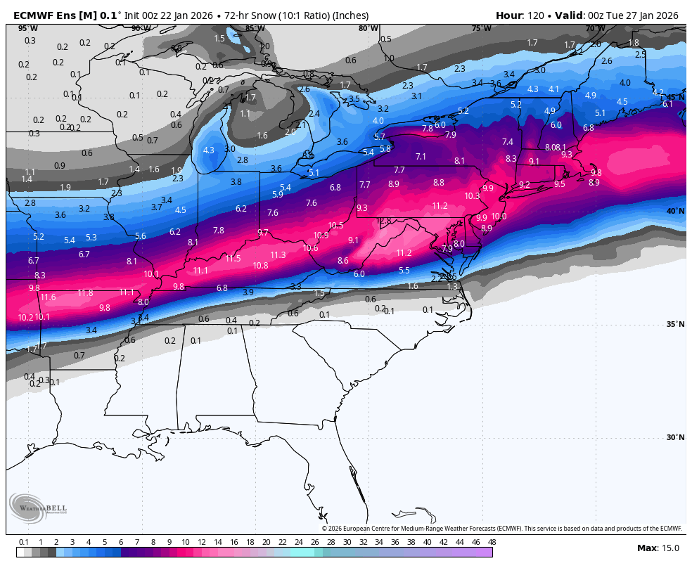
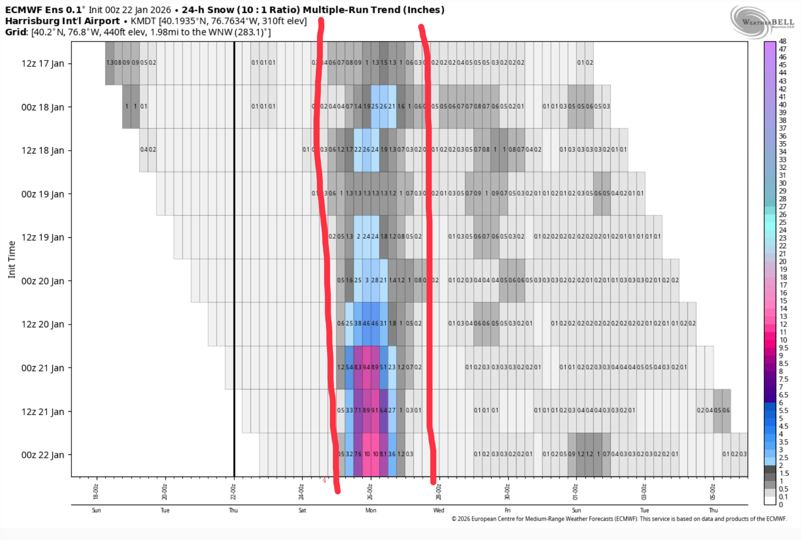
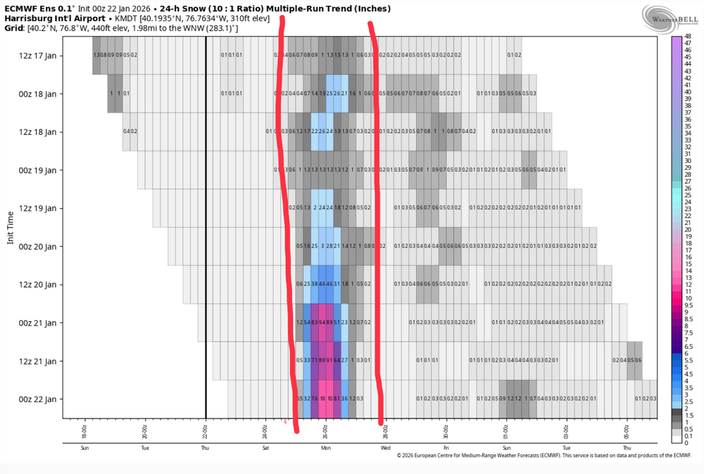
Looking over the 0z ensembles, they continue to be more supportive of an all snow outcome in all of C-PA despite the Euro and especially Canadian op creeping that mix line into southern PA. Here’s the Canadian ensemble members and p-type. Note that none of the members really intrude into PA with the mix line. A couple get close, but snow is predominant regardless. That factors pretty heavily into what your seeing on the NBM maps, as it blends all these ensembles. 0z Euro ensemble is fantastic Here’s the multi-run trend for MDT (Euro ensemble), you can see how this has really escalated the last couple days.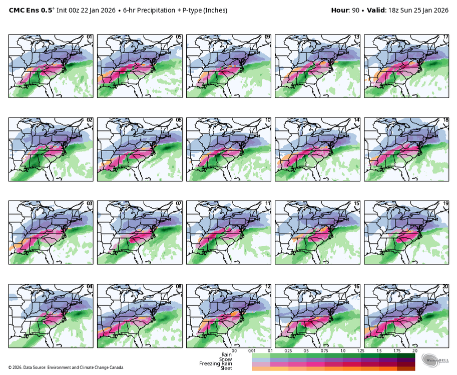

-
-
URGENT - WINTER WEATHER MESSAGE National Weather Service Baltimore MD/Washington DC 216 AM EST Thu Jan 22 2026 ...MAJOR WINTER STORM POSSIBLE THIS WEEKEND... .A large area of precipitation will overrun Arctic air in place over the Mid-Atlantic. This will likely lead to widespread significant snow beginning late Saturday, with the potential for ice Sunday especially south of Highway 50 and near and east of Interstate 95. In addition to the high threat for significant snow and ice, very cold temperatures are expected Friday night through the middle of next week with sub-zero wind chills likely at times. DCZ001-MDZ008-011-013-014-016>018-504-506-508-VAZ053>057-527-222115- /O.NEW.KLWX.WS.A.0001.260125T0000Z-260126T1200Z/ District of Columbia-Cecil-Southern Baltimore-Prince Georges-Anne Arundel-Charles-St. Marys-Calvert-Central and Southeast Montgomery-Central and Southeast Howard-Southeast Harford-Fairfax- Arlington/Falls Church/Alexandria-Stafford-Spotsylvania-King George-Central and Southeast Prince William/Manassas/Manassas Park- 216 AM EST Thu Jan 22 2026 ...WINTER STORM WATCH IN EFFECT FROM SATURDAY EVENING THROUGH MONDAY MORNING... * WHAT...Heavy snow mixed with sleet and freezing rain possible. There is a high likelihood of at least 5 inches of snow, with over 10 inches possible. Ice accumulation is also possible. * WHERE...DC, and portions of central, northeast, northern, and southern Maryland, and central and northern Virginia. * WHEN...From Saturday evening through Monday morning. * IMPACTS...Travel could be very difficult. The hazardous conditions could impact the Monday morning commute. * ADDITIONAL DETAILS...Snow will likely overspread the area Saturday evening, becoming heavy at times late Saturday night with rates of one to two inches per hour possible at times. A mix with sleet or freezing rain is possible Sunday. Significant icing is possible especially south of Highway 50. Visibility of one-quarter mile or less is possible at times. A prolonged period wind chills in the teens and single digits is likely beginning Friday evening and lasting through the middle of next week, with sub-zero wind chills possible at times. PRECAUTIONARY/PREPAREDNESS ACTIONS... Monitor the latest forecasts for updates on this situation. Now is the time to make preparations for the storm. This includes getting any necessary groceries or medicines that you may not be able to access this weekend into early next week due to any potential closure. Have an emergency kit in the car including extra batteries, a flashlight, and blanket just in case you get stranded. Make sure to refuel or charge your car before the storm hits. Check on elderly friends, family, and neighbors and don`t forget about pets or livestock during this prolonged cold period. && $$ DHOF/EST
-
Just got an alert on my phone for a winter storm watch.
-

January 25-26 Winter Storm Potential
CoolHandMike replied to Ralph Wiggum's topic in Philadelphia Region
WSW hoisted. Woo! -

Possible Record Breaking Cold + Snow Sunday 1/25 - Tuesday 1/27
Snowlover11 replied to TriPol's topic in New York City Metro
Watches flying all over in VA, PA. W NY. -
Finally....Wakefield adds central VA to WSW. This map is imoressive.
-

Pittsburgh/Western PA WINTER ‘25/‘26
blackngoldrules replied to Burghblizz's topic in Upstate New York/Pennsylvania
Winter Storm Watch URGENT - WINTER WEATHER MESSAGE National Weather Service Pittsburgh PA 204 AM EST Thu Jan 22 2026 OHZ039>041-048>050-057>059-068-069-PAZ013-014-020>022-029-031-073- 075-WVZ001>004-012-021-509>511-513-221515- /O.NEW.KPBZ.WS.A.0001.260125T0000Z-260126T1800Z/ Tuscarawas-Carroll-Columbiana-Coshocton-Harrison-Jefferson OH- Muskingum-Guernsey-Belmont-Noble-Monroe-Lawrence-Butler-Beaver- Allegheny-Armstrong-Washington-Greene-Westmoreland-Fayette-Hancock- Brooke-Ohio-Marshall-Wetzel-Marion-Monongalia- Ridges of Eastern Monongalia and Northwestern Preston-Preston- Western Tucker- Including the cities of Malvern, Greensburg, New Philadelphia, Monessen, Wheeling, Cambridge, Weirton, Zanesville, Parsons, Ambridge, Canonsburg, Coshocton, Dover, Uniontown, Cadiz, Fairmont, Follansbee, Salem, New Martinsville, Kittanning, Martins Ferry, Saint George, New Castle, Washington, East Liverpool, St. Clairsville, Butler, Bruceton Mills, Monaca, Caldwell, Kingwood, New Kensington, Beaver Falls, Wellsburg, Woodsfield, Aliquippa, Morgantown, Moundsville, Latrobe, Columbiana, Steubenville, Ellwood City, Murrysville, Waynesburg, Lower Burrell, Pittsburgh Metro Area, Hendricks, Coopers Rock, Ford City, and Carrollton 204 AM EST Thu Jan 22 2026 ...WINTER STORM WATCH IN EFFECT FROM SATURDAY EVENING THROUGH MONDAY AFTERNOON... * WHAT...Moderate to major impacts to the region are possible later this weekend with periods of moderate to heavy snow. * WHERE...Portions of east central Ohio, southwest and western Pennsylvania, and northern and the northern panhandle of West Virginia. * WHEN...From Saturday evening through Monday afternoon. * IMPACTS...Travel could be very difficult to impossible later this weekend and Monday morning. PRECAUTIONARY/PREPAREDNESS ACTIONS... Monitor the latest forecasts for updates on this situation. -
If we can get that coastal going like some models are doing at 0z this is going to be historic.. as it is now looks like most of SNE will see 12 to 18
-

January 2026 regional war/obs/disco thread
Torch Tiger replied to Baroclinic Zone's topic in New England
-

January 24-26: Miracle or Mirage JV/Banter Thread!
Mrs.J replied to SnowenOutThere's topic in Mid Atlantic
So have now seen two MD Universities, Frostburg and Salisbury, both put out messages to their students. Frostburg is opening up their dorms a day early on Saturday to accommodate students getting back to campus before the snow. Also opening up the dinning hall early and not charging. Salisbury is having a week of virtual classes starting Monday so that students do not need to rush back. Both the Ms. J’s are back on their campuses already as both of them started back within the last couple of weeks. I am making a run up to PA to drop off something for the kid up there and decided to go on Friday. Told the DC kid to get to the store and get what she needs. -

Richmond Metro/Hampton Roads Area Discussion
overcautionisbad replied to RIC Airport's topic in Mid Atlantic
Welp, gonna test my generator tomorrow. @#$% Who would've thought the Canadian would kind of be right days ago. The continued drought of major snow for RVA is pretty wild. -

January 2026 regional war/obs/disco thread
ineedsnow replied to Baroclinic Zone's topic in New England
Euro is beautiful next weekend also -
URGENT - WINTER WEATHER MESSAGE National Weather Service Wakefield VA 148 AM EST Thu Jan 22 2026 MDZ021>023-VAZ048-060>062-064-068-069-075-509>513-515-517-519-521- 221500- /O.NEW.KAKQ.WS.A.0001.260124T1800Z-260126T1800Z/ Dorchester-Wicomico-Somerset-Fluvanna-Prince Edward-Cumberland- Goochland-Caroline-Amelia-Powhatan-Westmoreland-Western Louisa- Eastern Louisa-Western Hanover-Eastern Hanover-Western Chesterfield-Western Henrico (Including the City of Richmond)- Western King William-Western King and Queen-Western Essex- 148 AM EST Thu Jan 22 2026 ...WINTER STORM WATCH IN EFFECT FROM SATURDAY AFTERNOON THROUGH MONDAY AFTERNOON... * WHAT...Heavy mixed precipitation possible. Confidence is increasing in widespread snow, sleet, and freezing rain. This may result in major impacts in infrastructure and transportation. * WHERE...Portions of southeast Maryland and central, east central, and north central Virginia. * WHEN...From Saturday afternoon through Monday afternoon. * IMPACTS...Roads, and especially bridges and overpasses, will likely become slick and hazardous. The combination of significant snow and ice accumulation on power lines and tree limbs may cause widespread and long-lasting power outages.
-
Watches up from Wakefield URGENT - WINTER WEATHER MESSAGE National Weather Service Wakefield VA 148 AM EST Thu Jan 22 2026 MDZ021>023-VAZ048-060>062-064-068-069-075-509>513-515-517-519-521- 221500- /O.NEW.KAKQ.WS.A.0001.260124T1800Z-260126T1800Z/ Dorchester-Wicomico-Somerset-Fluvanna-Prince Edward-Cumberland- Goochland-Caroline-Amelia-Powhatan-Westmoreland-Western Louisa- Eastern Louisa-Western Hanover-Eastern Hanover-Western Chesterfield-Western Henrico (Including the City of Richmond)- Western King William-Western King and Queen-Western Essex- 148 AM EST Thu Jan 22 2026 ...WINTER STORM WATCH IN EFFECT FROM SATURDAY AFTERNOON THROUGH MONDAY AFTERNOON... * WHAT...Heavy mixed precipitation possible. Confidence is increasing in widespread snow, sleet, and freezing rain. This may result in major impacts in infrastructure and transportation. * WHERE...Portions of southeast Maryland and central, east central, and north central Virginia. * WHEN...From Saturday afternoon through Monday afternoon. * IMPACTS...Roads, and especially bridges and overpasses, will likely become slick and hazardous. The combination of significant snow and ice accumulation on power lines and tree limbs may cause widespread and long-lasting power outages.
-
URGENT - WINTER WEATHER MESSAGE National Weather Service Wakefield VA 148 AM EST Thu Jan 22 2026 MDZ024-025-NCZ012-013-030-VAZ065>067-076>090-092-093-099-514-516-518- 520-522-523-221500- /O.NEW.KAKQ.WS.A.0001.260124T1800Z-260126T1800Z/ Inland Worcester-Maryland Beaches-Northampton-Hertford-Bertie- Mecklenburg-Lunenburg-Nottoway-Richmond-Northumberland-Lancaster- Brunswick-Dinwiddie-Prince George (including Hopewell and Petersburg)-Charles City-New Kent-Gloucester-Middlesex-Mathews- Greensville-Sussex-Surry-James City-Southampton-Isle of Wight- Accomack-Eastern Chesterfield (Including Col. Heights)-Eastern Henrico-Eastern King William-Eastern King and Queen-Eastern Essex- York- 148 AM EST Thu Jan 22 2026 ...WINTER STORM WATCH IN EFFECT FROM SATURDAY AFTERNOON THROUGH MONDAY AFTERNOON... * WHAT...Heavy mixed precipitation possible. Confidence is increasing in widespread snow, sleet, and freezing rain. This may result in major impacts in infrastructure and transportation. * WHERE...Portions of southeast Maryland, northeast North Carolina, and central, east central, eastern, south central, and southeast Virginia. * WHEN...From Saturday afternoon through Monday afternoon. * IMPACTS...Roads, and especially bridges and overpasses, will likely become slick and hazardous. The combination of significant snow and ice accumulation on power lines and tree limbs may cause widespread and long-lasting power outages.
-
URGENT - WINTER WEATHER MESSAGE National Weather Service Wakefield VA 148 AM EST Thu Jan 22 2026 NCZ014-031-VAZ095>098-100-524-525-221500- /O.NEW.KAKQ.WS.A.0001.260124T1800Z-260126T1800Z/ Gates-Chowan-Norfolk/Portsmouth-Suffolk-Chesapeake-Virginia Beach- Northampton-Newport News-Hampton/Poquoson- 148 AM EST Thu Jan 22 2026 ...WINTER STORM WATCH IN EFFECT FROM SATURDAY AFTERNOON THROUGH MONDAY AFTERNOON... * WHAT...Heavy mixed precipitation possible. Confidence is increasing in widespread snow, sleet, and freezing rain. This may result in moderate to major impacts in infrastructure and transportation. * WHERE...Portions of northeast North Carolina and eastern and southeast Virginia. * WHEN...From Saturday afternoon through Monday afternoon. * IMPACTS...Roads, and especially bridges and overpasses, may become slick and hazardous. Ice accumulation on power lines and tree limbs may result in power outages.
-
Another overperformer for many!! Yes!!
-

January 24-26: Miracle or Mirage JV/Banter Thread!
Wxtrix replied to SnowenOutThere's topic in Mid Atlantic
not clskinsfan but here in the EP: the Hampton Inn just outside town has good reviews, and you can walk to restaurants and a grocery store. we've stayed in Hilton Home2 Suites elsewhere and they have kitchens. it's in the same shopping center as the Hampton Inn. there's an inn in town and you can walk to restaurants and our locally-sourced grocery store but I don't know what will actually open on Sunday/Monday. but there will be great photo ops of the old part of town. my husband is recovering from emergency surgery (a great Christmas!! not) and is doing well, so we can't have guests right now. and of course the storm could shift away from us too. -
930pm evening AFD update snippet One thing to note regarding this evening`s guidance is that there has been a northern and western push which favors wintry mix across southern MD and central VA. The uncertainty remains in how far north this mix line evolves given the track of system whether it`s further to west or south of the region. The ECMWF, ICON, GFS, GEM, GEFS, and EPS illustrate this in different variations with a the highest probabilities of ice (i.e., sleet/some freezing rain) in the aformentioned areas above. Each of these solutions do have a variation of sleet mixing with snow and making it as far north as the I-95 corridor as the system kicks out Sunday afternoon. The probability of 0.01" of ice remains between 10 to 20 percent along I-66/US-50 and into I-95 north and east of DC. These values jump up to 25 to 35 percent across southern MD and central VA where slightly warmer air aloft/dry slotting may win out. The probabilities for significant/impactful snow have not changed a whole lot with the entire area seeing 65 to 85 percent probs of 6 to 8 inches snow. These probabilities drop down to 35 to 60 percent for a foot of snow, especially in the climo favored zones along and west of I-95 as well as down into northern Shenandoah Valley/Allegheny Mountains. This signal has trended upward in the last few runs, especially on the ECMWF/ECS as well as GEPS compared to the GEFS which focus this axis a bit further south. Of course these numbers will go up or down based upon any mixing that may occur. Snow to liquid ratios look to start around 15:1 with this system for the entirety of the area, while then trending down toward 10:1 and perhaps slightly lower Sunday morning into the afternoon as some mixing occurs. The pending dry slot could also play into this as well. Snow should be fluffy in nature, particularly within the initial warm advection conveyor belt. Expect some crustiness of this snowpack given any mixing that may occur as the system kicks out during the second half of Sunday. Now is the time for the public to make preparations for the storm. This includes getting any necessary groceries or medicines that you may not be able to access this weekend into early next week due to any potential closure. Have an emergency kit in the car including extra batteries, a flashlight, and blanket just in case you get stranded. Make sure to refuel your car before the storm hits. Check on elederly friends/neighbors and don`t forget about your pets during this prolonged cold period.
-
Liking 2-5” locally.
-
I WOULD say bring it - we have plenty of space - but being in the BR, I can't guarantee that you'll be able to get out before Tues or maybe even Wed. In 2016 it took them 3 days to get to us with large bulldozers driving down the middle of the road. Dump trucks couldn't push it.
-
Well since we have so many people on here that ride the euro we might as well start it because its showing it. .
-

“Cory’s in LA! Let’s MECS!” Jan. 24-26 Disco
H2Otown_WX replied to TheSnowman's topic in New England
Damn that is some pure wx porn right there. Does anyone have an idea what the ceiling is on this? Could we slowly see QPF bump up as we get closer? I was thinking with this much moisture we could see some 1.5"+ runs which if we get 15 or 20:1 ratios opens up the possibility of a HECS