All Activity
- Past hour
-

September 2025 OBS-Discussion centered NYC subforum
SACRUS replied to wdrag's topic in New York City Metro
Highs: PHL: 85 EWR: 83 ISP: 82 TEB: 81 New Brnswck: 81 JFK: 81 TTN: 81 LGA: 80 NYC: 79 ACY: 77 BLM: 76 -
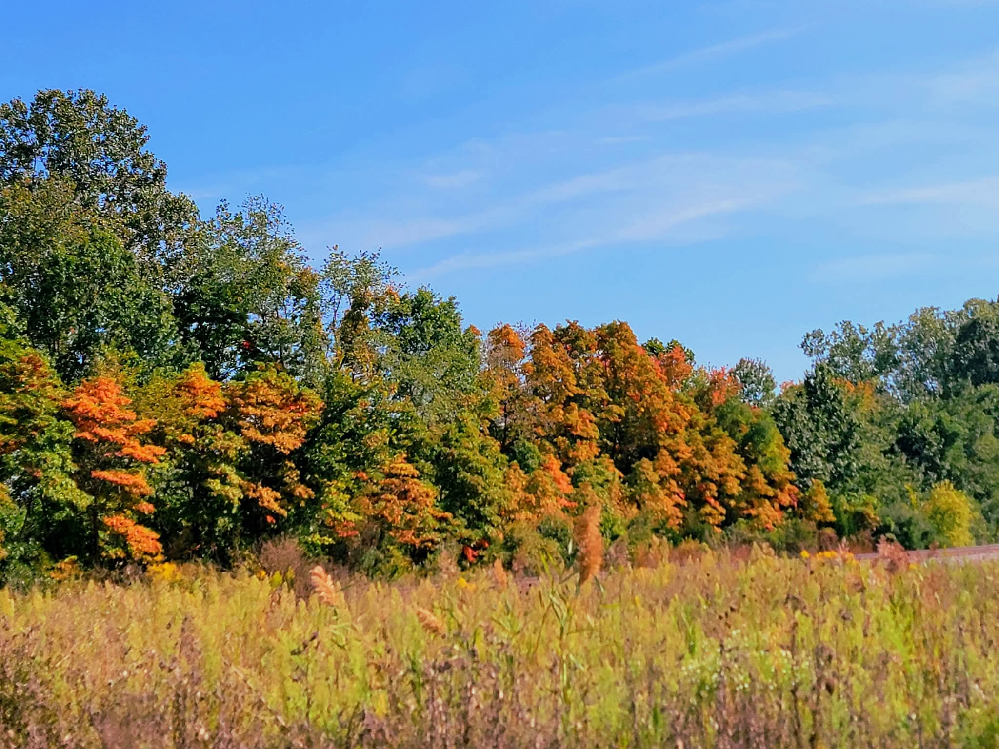
Saw some pockets of decent color on my drive to Willmar MN today.
-
Hmm, I think global warming coincides with less low level clouds and clouds in general. This is why it was always surprising to see global precipitation increase, and precipitable water. It makes sense that warm/dry would be the trajectory, but for the last few decades more moisture has happened by a lot.
-
Ok thank you
-

2025-2026 ENSO
michsnowfreak replied to 40/70 Benchmark's topic in Weather Forecasting and Discussion
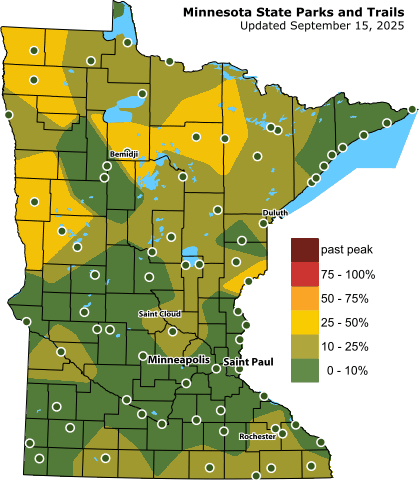
It is very dry and dusty here in southern MI. I took the day off and went apple picking with a friend. Apple crop is plentiful but not sure about corn here. I do know that color is well ahead of schedule.
-

September 2025 OBS-Discussion centered NYC subforum
weatherpruf replied to wdrag's topic in New York City Metro
two yamaha 115s, 25 foot 1986 whaler, my friend is the original owner...built to last. we've been beating ourselves up for 40 years....we had enough gas and plenty to spare. we did bring an extra ten gallons in case we had to run to the stacks, that's where all the fish are, but that's getting far for us. but we go far down the jersey shore too; there are no fish left in raritan bay just the fall striper run. so we often have to go to the shrewsbury rocks or the mud buoy or the donut, where the old ambrose tower was. needless to say, the marine forecasts can really mess you up when the get it wrong; and they often don't mention big swells from offshore storms, which can make you sick in a hurry. we also will fish coney island and the rockaways if the fish are there. -

September 2025 OBS-Discussion centered NYC subforum
psv88 replied to wdrag's topic in New York City Metro
That’s a very long ride. Did you refuel on the way back? What size boat/engines? -
September 2025 OBS-Discussion centered NYC subforum
weatherpruf replied to wdrag's topic in New York City Metro
yeah we really thought we had wasted the day until around 1 pm, when it laid down. i mean, ya gotta admit that was a long boat ride. raritan river to the arthur kill, kill van kull, ny harbor, east river through hell gate, and into the sound...and we still had to go a little distance in the sound as well. but it was still better than sitting at the gw bridge for 3 hours....or getting stuck on the cross bronx. -
No. There's a different dynamic involved. Because the Arctic warms faster near the surface but the tropics warm more in the upper atmosphere, wind shear is increasing at cruising altitudes, leading to more clear-air turbulence
-
Does this have anything to do with the increase in turbulence?
-
Summer is def over in the Roan Highlands. Avg temp for the first 15 days of the month is 59.3. The last few days have been seasonably cool.
-
With rising temperatures, cloud formation is occurring at higher altitudes. Thinner, high clouds are becoming relatively more common. Those clouds are idea for allowing in solar radiation and then slowing its escape. The thick stratocumulus clouds are become less frequent, yet it is those clouds that block out a lot of incoming solar radiation. This data is consistent with paleoclimate records and more recent climate modeling.
- Today
-
September 2025 OBS-Discussion centered NYC subforum
psv88 replied to wdrag's topic in New York City Metro
The marine forecast have been crap all summer. It’s always windier and rougher than forecast -
Awesome! Let's keep it going.
-
2022 was odd in that it ironically had the 10th highest Sept ACE of the current active era with way over the active era Sept avg ACE, but it also had the 3rd lowest ACE for Aug/Oct combined of the last 60 years behind only the super El Niños of 1997 and 1982.
- Yesterday
-
Man everyone skunked thru Oct there. Gonna get ugly in fire season with dry leaves , warm to hot fall and wind
-
Hail to the King
-

Invest 92L--60% two day, 90% five day odds
WxWatcher007 replied to WxWatcher007's topic in Tropical Headquarters
Yeah that's in the back of my mind, but I think the distinction here is the much larger moisture envelope and ability of this one to keep up convection. Environment looks pretty favorable for development/intensification in the subtropics too, which worked well with Fernand. -

Fall 2025 Medium/Long Range Discussion
Chicago Storm replied to Chicago Storm's topic in Lakes/Ohio Valley
ENS keep a re-loading a +EPO for the rest of the month. If nothing else were to factor in, that would keep the mild/warm temps in place. -

Invest 92L--60% two day, 90% five day odds
GaWx replied to WxWatcher007's topic in Tropical Headquarters
Now 60/90: is the long drought about to be broken? Keep in mind though that 91L also made it to 60/90 along with strong model support and surprisingly never developed: Tropical Weather Outlook NWS National Hurricane Center Miami FL 800 PM EDT Mon Sep 15 2025 For the North Atlantic...Caribbean Sea and the Gulf of America: 1. Central Tropical Atlantic (AL92): A broad area of low pressure is located about midway between the Windward Islands and the coast of west Africa. This system is showing signs of organization, and is expected to move through a favorable environment for further development. A tropical depression or tropical storm is likely to form by the middle to latter part of this week while the system moves west-northwestward at 10 to 15 mph over the central tropical Atlantic. * Formation chance through 48 hours...medium...60 percent. * Formation chance through 7 days...high...90 percent. Forecaster Pasch -

2025-2026 ENSO
40/70 Benchmark replied to 40/70 Benchmark's topic in Weather Forecasting and Discussion
I give you guys credit for forecasting a lame tropical season, but the consensus was not at all for a hyper active season. -
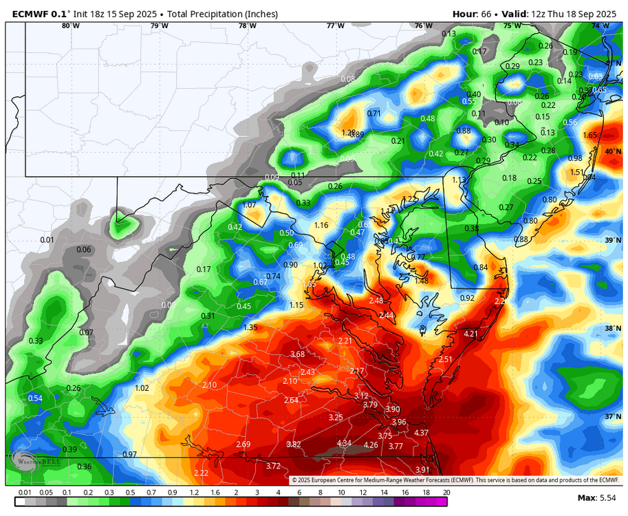
WB 18Z EURO....
-
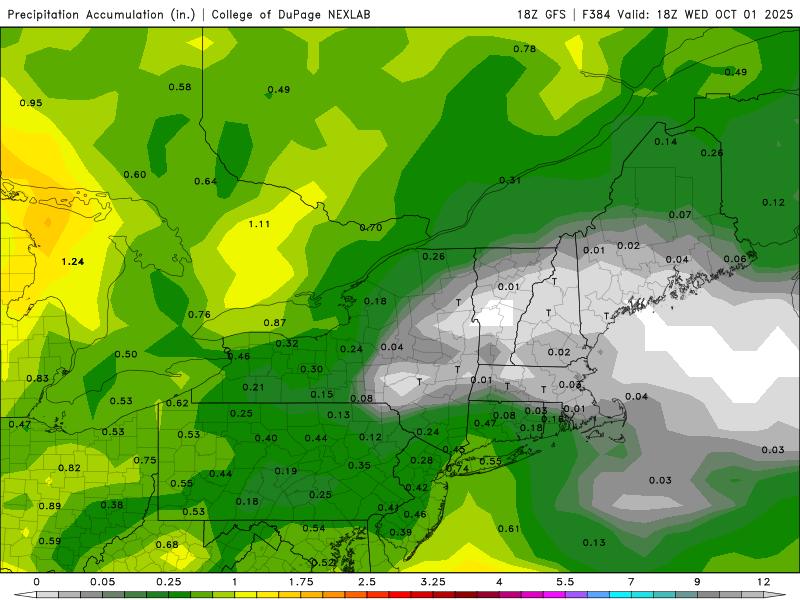
18z skunks me into October. Under an inch for Aug and Sep combined would be pretty funny. I’m not sure CON has even done that.
-
Great shot
-
Clouds are one of the tricky variables that climate models haven't really nailed down yet. They can have cooling and warming effects.